Volcanoes have shaped some of the most spectacular landscapes on Earth. Across the globe, ancient eruptions have created dramatic lava fields, towering craters, rugged coastlines, and otherworldly terrain that continues to captivate travelers and scientists alike.
These volcanic regions are more than scenic destinations – they are living reminders of the powerful forces that shaped our planet. From remote islands to mountain ranges, these 14 remarkable landscapes showcase the beauty that can emerge from Earth’s most explosive events.
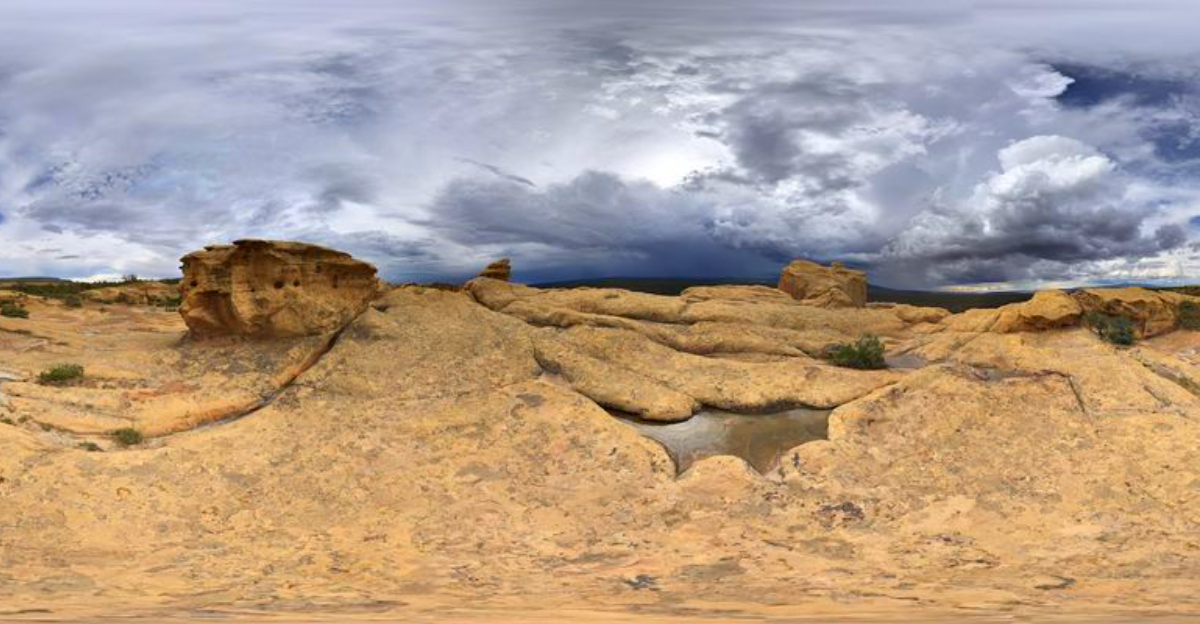
1. Iceland’s Reykjanes Peninsula, Iceland

Few places on Earth make you feel quite as small as the Reykjanes Peninsula, a stretch of land where the ground looks like it just finished arguing with itself. Located in southwestern Iceland, this peninsula sits directly on the Mid-Atlantic Ridge, the boundary where two tectonic plates pull apart from each other at a rate of about two centimeters per year.
The landscape is dominated by hardened lava fields, volcanic craters, and geothermal areas where the earth releases heat from deep below. The Fagradalsfjall volcano, which erupted as recently as 2021, added fresh lava to a terrain already shaped by thousands of years of eruptions.
Visitors can walk marked trails across the lava fields and observe geothermal features up close. The peninsula is also home to the famous Blue Lagoon geothermal spa, which draws visitors from around the world.
This is volcanic tourism at its most accessible.
2. Auvergne Volcanoes Regional Nature Park, France

Central France has a secret it has been sitting on for about 10,000 years. The Auvergne Volcanoes Regional Nature Park covers roughly 395,000 hectares and contains the Chaine des Puys, a perfectly aligned chain of about eighty volcanic cones that stretch across the landscape like nature’s own mountain range.
The volcanoes are dormant, which means the forests have had plenty of time to grow back and soften the dramatic terrain. Hikers can climb the Puy de Dome, the tallest of the chain at 1,465 meters, and look out over a landscape that reveals the sheer scale of ancient volcanic activity.
The park was added to the UNESCO World Heritage list in 2018, recognizing its outstanding geological value. Beyond the geology, the region is also known for its medieval towns and traditional French countryside.
The volcanoes here are quiet, but their legacy is anything but subtle.
3. Craters of the Moon National Monument, Idaho, United States

NASA actually trained astronauts here in the 1960s, and once you see the place, the choice makes perfect sense. Craters of the Moon National Monument in southern Idaho covers over 1,100 square miles of lava fields, cinder cones, and volcanic formations that look genuinely alien.
The lava flows visible today were produced by eruptions that occurred between 15,000 and 2,000 years ago, making this one of the geologically youngest volcanic landscapes in the continental United States. The Great Rift, a series of fractures in the Earth’s crust running through the monument, was the source of most of these eruptions.
Visitors can explore lava tube caves, climb cinder cones, and walk through fields of hardened basalt. The monument is jointly managed with the Craters of the Moon National Preserve, expanding the protected area significantly.
For anyone interested in volcanic geology, this is one of the most accessible and impressive sites in the American West.
4. Timanfaya National Park, Lanzarote, Canary Islands, Spain

Between 1730 and 1736, a series of eruptions on Lanzarote buried eleven villages and reshaped a quarter of the island forever. The result is Timanfaya National Park, one of the most visually striking volcanic landscapes in all of Europe.
The park covers about 5,100 hectares and contains the Montanas del Fuego, or Fire Mountains, a collection of volcanic craters and hardened lava fields that display an extraordinary range of colors. The reds, oranges, blacks, and browns come from different mineral compositions in the volcanic rock.
What makes Timanfaya particularly remarkable is that no plants or animals are officially allowed inside the protected core zone, preserving the raw volcanic landscape almost exactly as it looked after the eruptions. Visitors tour the park by bus along a route designed by the artist Cesar Manrique.
The geothermal heat beneath the surface is still measurable, with ground temperatures reaching well above 100 degrees Celsius just a few meters down.
5. Mount Etna Region, Sicily, Italy

Europe’s most active volcano has been erupting regularly for at least 2,700 years, and the people of Sicily have built their lives quite literally in its shadow. Mount Etna rises to about 3,350 meters above sea level, though its exact height changes slightly with each eruption that adds or removes material from its summit.
The volcanic soil on Etna’s slopes is extraordinarily fertile, which explains why vineyards, orchards, and towns have thrived there for centuries despite the geological risk. Ancient lava flows from past eruptions have hardened into distinct layers that geologists can read like a timeline of the mountain’s history.
Etna has multiple craters at its summit and dozens of smaller parasitic cones along its flanks. Guided tours take visitors up the slopes by cable car and four-wheel-drive vehicles, offering close access to recent lava formations.
The combination of active geology, agricultural history, and Mediterranean scenery makes this region genuinely unlike anywhere else in Europe.
6. El Malpaís National Monument, New Mexico, United States

The Spanish word malpaís means bad land, a name that early travelers gave to terrain that was nearly impossible to cross on foot. El Malpais National Monument in western New Mexico preserves one of the most extensive lava flow systems in the American Southwest, covering over 376,000 acres of volcanic terrain.
The lava flows here range in age from about 3,000 to 115,000 years old, meaning visitors are looking at multiple chapters of volcanic activity rather than a single event. The monument contains more than twenty-five miles of lava tubes, some of which still hold ice year-round due to their depth and insulation.
Sandstone bluffs and mesas frame the edges of the lava fields, creating a dramatic contrast between the dark volcanic rock and the warm tan of the surrounding desert landscape. Ancient Native American trails once crossed this terrain, and petroglyphs can still be found in the area.
The monument sits adjacent to El Malpais National Conservation Area, expanding the total protected landscape considerably.
7. Hawaiʻi Volcanoes National Park, Hawaiʻi, United States

The Hawaiian Islands did not always exist. They were built, one eruption at a time, from the ocean floor up, and that process is still happening today on the Big Island.
Hawaii Volcanoes National Park protects two of the world’s most active volcanoes, Kilauea and Mauna Loa, and offers visitors a front-row seat to ongoing geological history.
Kilauea has been erupting almost continuously since 1983, making it one of the longest-running eruptions ever recorded. The park covers over 323,000 acres of volcanic landscape, from sea-level lava benches to the summit caldera at roughly 4,000 feet elevation.
Crater Rim Drive takes visitors around the edge of Kilauea’s summit caldera, passing through rainforest, desert, and barren lava fields within just a few miles. The park is a UNESCO World Heritage Site and an International Biosphere Reserve.
For anyone fascinated by how continents and islands form, this park is essentially a live demonstration.
8. Garrotxa Volcanic Zone Natural Park, Catalonia, Spain

Northern Spain is not the first place most people think of when they hear the word volcano, which makes Garrotxa one of Catalonia’s best-kept geological secrets. The Garrotxa Volcanic Zone Natural Park contains more than forty volcanic cones, making it one of the best-preserved volcanic areas in the entire Iberian Peninsula.
The youngest eruption in the region occurred roughly 11,000 years ago, which means the volcanoes are considered dormant rather than extinct. Over thousands of years, dense forests of oak and beech have grown across the cones, giving the landscape a lush, almost parklike quality that hides its dramatic geological origins.
The medieval town of Besalu sits nearby, adding a historical layer to what is already a geologically fascinating area. Trails wind through the park and up the sides of the cones, with the Croscat volcano offering an exposed cross-section of volcanic layers that researchers have studied extensively.
This is where geology and history share the same hiking trail.
9. Tongariro National Park, North Island, New Zealand

New Zealand’s oldest national park is also one of its most geologically dramatic, covering a landscape shaped by eruptions that began hundreds of thousands of years ago and continue today. Tongariro National Park sits in the central North Island and is dominated by three active volcanic peaks: Tongariro, Ngauruhoe, and Ruapehu.
The Tongariro Alpine Crossing, often described as one of the best single-day hikes in the world, takes walkers across ancient lava fields, past volcanic craters, and alongside the vivid blue-green Emerald Lakes, which owe their color to minerals leached from surrounding volcanic rock.
The park holds dual UNESCO World Heritage status, recognized for both its natural significance and its cultural value to the Maori people, for whom the mountains are considered sacred ancestors. Mount Ruapehu last erupted in 2007, a reminder that this landscape is still actively evolving.
The combination of cultural depth and raw geological power makes Tongariro unlike any other national park in the Southern Hemisphere.
10. La Palma, Canary Islands, Spain

In 2021, the Cumbre Vieja volcano on La Palma erupted for 85 days, adding an entirely new section of land to the island’s southwestern coastline. That event reminded the world that La Palma is not just historically volcanic but actively so, with a geological story still being written in real time.
The island is shaped like a teardrop and divided dramatically between the lush, forested northern half and the stark volcanic terrain of the south. Ancient lava flows have created a rugged coastline of black rock cliffs and small volcanic beaches that contrast sharply with the green interior.
La Palma is also home to the Caldera de Taburiente National Park, centered on a massive erosion caldera roughly nine kilometers wide.
11. Jeju Island, South Korea

South Korea’s largest island was born entirely from volcanic activity, and the evidence is visible everywhere you look. Jeju Island formed from eruptions of the Hallasan shield volcano, which at 1,950 meters is the highest peak in South Korea, and from hundreds of smaller parasitic cones called oreum scattered across the island.
The Manjanggul lava tube, one of the longest in the world at about 13.4 kilometers, runs beneath the island’s surface and is open to visitors for about one kilometer of its length. The tube formed when the outer surface of a lava flow cooled and hardened while molten lava continued flowing through the interior and eventually drained out.
Jeju was designated a UNESCO World Natural Heritage Site in 2007, recognizing its lava tubes, volcanic cones, and Hallasan itself as outstanding examples of volcanic geology.
12. Mount Cameroon Region, Southwest Region, Cameroon

At 4,095 meters, Mount Cameroon is the highest peak in West and Central Africa, and it is one of the continent’s most active volcanoes, with eruptions recorded as recently as 2012. The mountain rises dramatically from near sea level to its summit in a relatively short horizontal distance, creating one of the most striking volcanic profiles on the continent.
Ancient lava flows have shaped both the mountain’s slopes and the surrounding coastline, where hardened basalt meets the Gulf of Guinea. The base of the mountain is covered in dense tropical rainforest, one of the most biodiverse forests in Africa, which gradually gives way to alpine grassland and bare volcanic rock at higher elevations.
13. Valley of Fire State Park, Nevada, United States

Nevada’s oldest state park has a name that sounds like it was invented specifically for a travel brochure, but the geology behind it is completely real. The Valley of Fire covers about 46,000 acres of desert terrain where ancient geological forces, including volcanic activity in the surrounding region, helped shape the dramatic rock formations visible today.
The park’s most famous feature is its vivid red Aztec sandstone, formed from sand dunes that were compressed into rock roughly 150 million years ago. Volcanic activity in the broader region contributed to the complex geological history that tilted, fractured, and exposed these layers over time.
The park contains over 4,000 petroglyphs carved by the Ancestral Puebloans, who used the area for hunting and ceremonies over a period spanning nearly a thousand years.
14. Dimmuborgir Lava Fields, Norðurland Eystra, Iceland

The name Dimmuborgir translates from Icelandic as Dark Castles, and standing among its towering lava formations, it is easy to understand why. Located near Lake Myvatn in northern Iceland, this unusual lava field formed roughly 2,300 years ago when a lava lake collapsed as lava flowed beneath it and drained away, leaving behind a surreal collection of towers, arches, and hollow columns.
The structures reach heights of several meters and take on shapes so unusual that Icelandic folklore placed the entrance to the underworld somewhere within the formation. Local Christmas tradition even identifies Dimmuborgir as the home of the thirteen Yule Lads, Iceland’s mischievous holiday figures.
Marked walking trails of varying lengths wind through the lava field, allowing visitors to explore the formations up close without disturbing the fragile rock.


