Some cities exist in places that make you stop and ask, “How is this even possible?” From sheer cliffsides to frozen tundra and volcanic craters, humans have always found ways to build communities where nature said no. These 15 cities pushed back against mountains, deserts, gorges, and tides to become thriving places full of history and wonder. Get ready to be seriously impressed by human stubbornness and creativity.
Petra, Jordan

Rose-red and jaw-dropping, Petra looks less like a city and more like something out of a fantasy novel. The Nabataeans carved this entire metropolis directly into sandstone cliffs over 2,000 years ago, creating temples, tombs, and homes from solid rock.
Their biggest challenge was not carving, though. It was finding water in one of the driest places on Earth.
The Nabataeans solved this with a brilliant network of channels, pipes, and cisterns that collected and stored every drop of rainfall. Engineers today still study their system as a masterpiece of ancient hydraulic design.
Without it, Petra would have been abandoned within a generation.
At its peak, Petra housed roughly 30,000 people, making it a booming trade hub connecting Arabia, Egypt, and the Mediterranean. Today, visitors hike through the famous Siq, a narrow canyon passage that suddenly opens to reveal the Treasury facade.
The experience is genuinely breathtaking. Petra was lost to the Western world for centuries until explorer Johann Ludwig Burckhardt rediscovered it in 1812.
It remains one of the most visited archaeological sites on the planet, and honestly, it earns every bit of that fame.
Santorini (Fira and Oia), Greece
, Greece")
Perched on the crumbling edge of a volcanic caldera, Santorini’s towns look like they could slide into the sea at any moment. Spoiler: they have not, and they have been there for thousands of years.
The island itself is what remains after one of the most catastrophic volcanic eruptions in recorded history, which happened around 1600 BCE.
Fira and Oia sit hundreds of meters above the Aegean Sea, clinging to cliffs made from volcanic rock and compacted ash. Building here was never easy.
Construction crews had to haul materials up steep, winding paths, and earthquakes have repeatedly damaged structures over the centuries. A major quake in 1956 nearly wiped out both towns entirely.
Despite all of that, people kept rebuilding. The iconic whitewashed walls and blue-domed churches were not just aesthetic choices.
White reflects intense summer heat, and the curved domes were easier to build with limited materials. The result is one of the most photographed skylines in the world.
Santorini today draws millions of visitors annually, all arriving to witness towns that technically should not exist on terrain that is literally the rim of a volcano. That is some serious commitment to real estate.
Shibam, Yemen

Before New York had skyscrapers, Shibam had mud towers. This ancient Yemeni city features multi-story mudbrick buildings that soar up to eleven stories high, making it one of the earliest examples of vertical city planning anywhere on Earth.
Locals started building upward rather than outward because the flat desert valley offered limited defensible space.
Shibam sits in the Hadhramaut Valley and has been continuously inhabited for roughly 1,700 years. The towers were not just impressive architecture.
They were survival strategy. Building tall kept residents safe from flash floods and Bedouin raids.
The higher your floor, the safer your family. That logic shaped an entire skyline.
Maintaining these buildings is a constant job. Mudbrick needs regular replastering to withstand rain and wind erosion.
Families pass down repair knowledge through generations, keeping centuries-old towers standing through sheer community effort. UNESCO recognized Shibam as a World Heritage Site in 1982, calling it the “Manhattan of the Desert,” a nickname that stuck.
Unfortunately, ongoing conflict in Yemen has put the city at serious risk. Preservation efforts continue despite difficult circumstances, because losing Shibam would mean losing one of humanity’s most extraordinary urban experiments.
It deserves to survive.
La Rinconada, Peru

At 5,100 meters above sea level, just breathing in La Rinconada is an achievement. This Peruvian gold-mining town sits higher than any permanent human settlement on Earth, clinging to the slopes of a glacier in the Andes Mountains.
The air holds about 40 percent less oxygen than at sea level, which means headaches, dizziness, and exhaustion are just part of daily life for residents.
The town grew rapidly in the early 2000s when gold prices spiked globally. Thousands of miners flooded in, hoping to strike it rich.
Infrastructure never caught up with the population boom. There is no running water, no sewage system, and garbage piles up across the mountainside because no waste management service can reliably operate at this altitude.
Despite those brutal conditions, roughly 50,000 people call La Rinconada home. Many work under a traditional payment system called cachorreo, where miners receive no wages for most of the month, then on one designated day they can take as much ore as they can carry.
It is a high-risk gamble that keeps people coming back. La Rinconada is a place where ambition and hardship exist in equal measure, set against one of the most dramatic mountain landscapes you will ever see.
Yanjin, China

Yanjin makes other cramped cities look spacious. Located in Yunnan province, this Chinese city is officially recognized as the world’s narrowest urban area, squeezed between towering mountain walls and the rushing Guanhe River.
In the tightest spots, the city is barely 30 meters wide from one side to the other. That is narrower than some hotel lobbies.
Building here required extraordinary creativity. Architects designed structures that lean against cliff faces, extend over the river on supports, and stack vertically to make up for the total lack of horizontal space.
Roads, buildings, and bridges have to share the same sliver of land, making city planning an ongoing puzzle with almost no room for error.
Floods are a constant threat since the river that hemmed Yanjin in also occasionally rises dramatically during heavy rain seasons. Engineers have reinforced riverbanks and built flood barriers, but the city remains vulnerable.
Despite all of this, Yanjin has a population of hundreds of thousands across its wider county, with the urban core being a fascinatingly tight knot of human activity. Visiting feels like walking through a city that was designed by someone who ran out of space halfway through and just kept building anyway.
Somehow, it works beautifully.
Civita di Bagnoregio, Italy

Civita di Bagnoregio is slowly disappearing, and somehow that makes it even more beautiful. This tiny Italian hill town sits atop a crumbling volcanic plateau in Lazio, connected to the modern world by a single narrow pedestrian bridge.
The plateau is made of tufa, a soft volcanic rock that erodes steadily under wind and rain. The town is literally shrinking year by year.
The Etruscans founded Civita over 2,500 years ago, choosing the elevated position for defense. Back then, the plateau was much larger and more stable.
Over centuries, earthquakes and erosion have carved away the surrounding land, leaving the town perched on an increasingly fragile island of rock. Today, only a handful of permanent residents remain, mostly elderly locals who have spent their whole lives there.
The nickname “the dying city” feels dramatic but accurate. Geologists estimate that without serious intervention, significant portions of the plateau could collapse within decades.
Italian authorities and international preservation groups are working on stabilization projects, but the battle against erosion is expensive and never-ending. Tourists who make the walk across the bridge find a remarkably preserved medieval village frozen in time.
Cobblestone streets, stone archways, and flower-filled doorways make it heartbreakingly lovely. Visiting feels urgent, like catching something rare before it disappears forever.
Meteora, Greece

Imagine deciding that the top of a 400-meter sandstone pillar sounds like a perfectly reasonable place to build a community. That is exactly what the monks and settlers of Meteora did, and somehow it worked out spectacularly.
Located in central Greece, Meteora features a cluster of towering rock formations that shoot straight up from the valley floor like giant stone fingers.
Hermit monks began living in the caves and crevices of these pillars as early as the 9th century. By the 14th century, they were constructing full monasteries on the summits.
Getting building materials up there was no small task. Monks used rope ladders, nets, and hand-cranked winches to haul everything from timber to water to livestock up the sheer rock faces.
The process took enormous patience and faith.
At the height of Meteora’s monastic community, 24 monasteries operated across the rock formations. Today, six remain active and are home to monks and nuns who still live a largely traditional religious life above the clouds.
The site draws visitors from around the world, many of whom hike or take winding mountain roads to reach the summits. Meteora became a UNESCO World Heritage Site in 1988.
Standing at the base and looking up at a monastery clinging to the top of a rock pillar is a genuinely surreal experience that photographs can never fully capture.
Ronda, Spain

Ronda is the kind of city that makes you grip the railing a little tighter. Sitting atop a plateau that splits dramatically at a gorge nearly 120 meters deep, this Andalusian city looks like it was placed there by someone with a flair for the theatrical.
The El Tajo gorge slices straight through the rock, dividing Ronda into two distinct neighborhoods connected by the famous Puente Nuevo bridge.
Construction of the Puente Nuevo, which translates to “New Bridge,” took 42 years and was completed in 1793. During that time, the original bridge collapsed, killing 50 workers.
The replacement has stood firm ever since, though the construction foreman reportedly fell to his death while trying to inspect it. The bridge now houses a small museum inside its central arch.
Ronda’s location was chosen for military defense. The gorge made the city nearly impenetrable from three sides, which proved invaluable during centuries of conflict between Moorish and Spanish Christian kingdoms.
The city was one of the last Moorish strongholds in Andalusia before falling to Ferdinand and Isabella in 1485. Today, Ronda is celebrated for its bullfighting history, its gorgeous old town architecture, and views from the cliff edge that will make your stomach drop in the best possible way.
Masada, Israel

Masada is proof that humans will go to extraordinary lengths to feel safe. Herod the Great built this fortress-palace complex atop an isolated plateau in the Judean Desert around 30 BCE, choosing a location that was genuinely miserable to reach but nearly impossible to attack.
The plateau rises about 400 meters above the surrounding desert, with sheer cliffs on every side.
Getting water up there was the biggest engineering challenge. Herod’s architects designed an elaborate system of aqueducts and cisterns carved into the rock that could store millions of liters of rainwater.
The system was so effective that Masada could sustain a large population for years without resupply. That foresight proved critical during the famous siege of 73 CE, when nearly 1,000 Jewish rebels held off the entire Roman Tenth Legion for months.
The Romans eventually built a massive earthen ramp up the western side of the plateau, a construction feat that took thousands of soldiers months to complete. When they finally breached the walls, they found the defenders had chosen death over capture.
The story of Masada became a powerful symbol of resistance in Jewish history and later in Israeli national identity. Today, a cable car carries visitors to the top, making the journey considerably easier than it was for either the defenders or their attackers.
Ouarzazate, Morocco

Gateway cities often get overlooked in favor of the destinations beyond them, but Ouarzazate refuses to be ignored. Sitting on a high barren plateau at the edge of the Sahara in southern Morocco, this city developed at a crossroads where trade routes from sub-Saharan Africa met paths heading north through the Atlas Mountains.
Its location was harsh but strategically brilliant.
The name Ouarzazate roughly translates from Berber as “without noise” or “without confusion,” which feels ironic given how busy the city became as a caravan hub. Merchants moving gold, salt, slaves, and spices all passed through, making Ouarzazate a melting pot of cultures long before that term existed.
The famous Ait Ben Haddou ksar, a UNESCO World Heritage Site nearby, shows just how sophisticated desert architecture became in this region.
Modern Ouarzazate found an unexpected second identity as a film production hub. The dramatic desert landscapes and ancient kasbahs have served as backdrops for films like Gladiator, Lawrence of Arabia, and Game of Thrones.
Hollywood studios have built permanent facilities in the city, earning it the nickname “the Hollywood of Morocco.” That combination of ancient trade history and modern film glamour makes Ouarzazate one of the most unexpectedly layered cities on this entire list. The desert did not stop it.
It became its biggest asset.
Setenil de las Bodegas, Spain

Most towns are built under the open sky. Setenil de las Bodegas decided a giant rock overhang made for perfectly good roofing.
This quirky Andalusian village in Cadiz province is built directly beneath enormous ledges of volcanic rock, with entire streets running under cliff faces that act as natural ceilings. Walking through certain neighborhoods feels like exploring a cave system that someone decided to move into permanently.
The settlement has existed since at least the Moorish period, and the overhanging rocks provided obvious advantages. Natural shade kept interiors cool during scorching Andalusian summers.
The rock faces also provided protection from rain and wind. Residents essentially let geology do most of the architectural heavy lifting, plastering their whitewashed walls directly against the stone and letting the cliff handle the rest.
Setenil was also a significant military stronghold. It took the forces of Ferdinand and Isabella ten separate attempts before they finally captured it from Moorish defenders in 1484, largely because the natural rock formations made the town extremely difficult to breach.
Today, the most famous street is Calle Cuevas del Sol, where restaurants and shops sit snugly beneath overhangs so large they dwarf the buildings below. Visitors frequently stop mid-meal to marvel at the fact that a cliff is quite literally their ceiling.
It is genuinely one of Europe’s most unusual dining experiences.
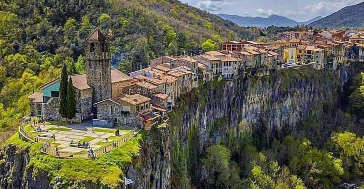
Castellfollit de la Roca, Spain

Standing at the base of Castellfollit de la Roca and craning your neck upward is one of those experiences that makes your brain momentarily short-circuit. This Catalan village sits on a basalt cliff just 50 meters wide and roughly 1 kilometer long, formed by two ancient lava flows that hardened into sheer vertical walls over a million years ago.
The village sits right on the edge, with some buildings literally overhanging the drop.
The cliff rises about 50 meters above the confluence of two rivers, the Fluvia and the Toronell. Medieval settlers chose this location because the natural rock fortress was nearly impossible to storm.
Building on top of a narrow lava column presented obvious challenges, including the complete absence of expansion room. Every new building had to fit within the existing footprint, which is why Castellfollit never grew very large.
Today, the village has a population of around 1,000 people, making it one of the smallest municipalities in Catalonia. Visitors arrive specifically to walk the cliff-edge path and peer over the side at the dizzying drop to the rivers below.
The village also has a small sausage museum dedicated to local charcuterie traditions, which is either charmingly random or perfectly Catalan, depending on your perspective. Either way, the cliff alone makes the trip more than worth it.
Yakutsk, Russia

Yakutsk holds a title nobody was racing to claim: coldest major city on Earth. Located in Siberia, this Russian city regularly sees winter temperatures plunge below minus 40 degrees Celsius, and in extreme years it has hit minus 60.
Exposed metal sticks to bare skin instantly. Vehicles must be kept running around the clock or their engines freeze solid.
Even eyelashes frost over within minutes outdoors.
The ground beneath Yakutsk is permanently frozen, a condition called permafrost that extends hundreds of meters deep. This creates a construction nightmare.
Warm buildings sitting directly on permafrost melt the top layer, causing the ground to shift and sink unevenly. Early buildings in the city literally tilted and collapsed as their foundations gave way.
Engineers solved this by placing all structures on steel or concrete stilts, keeping a gap between the building and the frozen ground so heat cannot escape downward.
Despite conditions that sound like a survival scenario, Yakutsk has a population of over 300,000 people. The city is a hub for diamond mining, as the surrounding region contains some of the world’s richest diamond deposits.
Residents have adapted in remarkable ways, from underground heated pedestrian tunnels to special winter tires that stay flexible in extreme cold. Yakutsk proves that with enough engineering creativity, humans can make almost any environment livable.
Though perhaps not comfortable.
Vardzia, Georgia

Vardzia was not built on a mountain. It was carved into one.
This extraordinary cave city in southern Georgia was created during the reign of Queen Tamar in the 12th century, when workers cut hundreds of chambers, churches, wine cellars, stables, and living quarters directly into the face of a volcanic cliff. At its height, Vardzia reportedly housed up to 50,000 people inside the rock itself.
The city served as both a military stronghold and a monastic center. Its hidden position made it nearly invisible to approaching enemies.
Residents entered through concealed passages, and the entire complex was connected by tunnels, making it possible to move through the city without ever stepping outside. A sophisticated irrigation system brought water from the Mtkvari River up into the cliff, supporting agriculture on terraced fields above.
A massive earthquake in 1283 shook loose the outer layers of the cliff, exposing the cave rooms to the outside world and destroying much of the concealment that made Vardzia so defensible. Persian invasions in the 16th century dealt another devastating blow.
Today, only a small community of monks remains in a functioning section of the cave complex, maintaining one of the most hauntingly beautiful archaeological sites in the Caucasus region. Walking through Vardzia feels like stepping inside a mountain that chose to become a city.
Mont-Saint-Michel, France

Twice a day, the sea swallows the roads to Mont-Saint-Michel and leaves this medieval island completely surrounded by water. Located off the coast of Normandy, this rocky tidal island rises 92 meters above the bay and has been home to a community of monks, villagers, and pilgrims for over 1,300 years.
The tides here are among the fastest-moving in Europe, rushing in at speeds described as fast as a galloping horse.
Building on the island required solving one impossible problem after another. Fresh water had to be collected from rainfall since the island had no natural springs.
Food supplies needed constant ferrying from the mainland. The foundation of the famous abbey at the summit required constructing massive crypts beneath it to support the weight of the structure on the rocky peak.
Medieval engineers essentially invented solutions as they went.
During the Hundred Years War, Mont-Saint-Michel was one of the few places in Normandy that the English never managed to capture, thanks to its tidal defenses and fortified walls. It later served as a prison during the French Revolution and through the 19th century.
A modern causeway now connects the island to the mainland, though engineers designed it to allow tidal waters to flow freely beneath it, restoring the island’s natural flooding cycle after decades of disruption. Around three million visitors come each year to see a place that genuinely should not exist, yet stubbornly does.


