There is a trail in northern Minnesota where the river splits in two, and half of it simply vanishes into a volcanic rock pothole with no confirmed exit point. Scientists have tried to trace it.
Dye tests, ping pong balls, you name it. Nobody knows where the water goes.
That mystery alone is worth the drive, but Judge C.R. Magney State Park delivers so much more than one geological riddle.
The forest feels thick and ancient, the Brule River rushes loud enough to drown out your thoughts, and the whole scene carries a moody, moss-drenched energy that most people associate with the Oregon coast rather than the Minnesota shoreline. This article walks you through everything that makes this park so worth your time, from the trail conditions to the camping, the waterfalls, and the best tips for making the most of your visit.
Where This Park Actually Is

Judge C.R. Magney State Park sits at 4051 MN-61, Grand Marais, MN 55604, tucked along the North Shore of Lake Superior about 15 minutes north of Grand Marais.
That small distance from town makes a surprisingly big difference in terms of crowd levels and atmosphere.
The park entrance is right off Highway 61, which is the same scenic road that hugs the Lake Superior coastline and draws road-trippers every fall. You will see a sign for the park and a spacious trailhead parking area where you can purchase a daily parking pass digitally if you have not already bought one.
Getting here early is a smart move, especially on weekends, because the parking lot fills faster than you might expect for a park this far up the shore. Plan your arrival before 9 a.m. if you want a stress-free start.
The Story Behind the Park’s Name

Not every state park gets named after someone who genuinely earned the honor. Clarence R.
Magney was a mayor of Duluth, a Minnesota Supreme Court justice, and one of the most determined advocates for preserving the North Shore’s natural spaces during the early 20th century.
He fought to protect dozens of miles of Lake Superior shoreline and pushed for the creation of multiple state parks along what is now Highway 61. The park bearing his name opened in 1957, and it stands as a direct result of his conservation work over several decades.
Knowing that history adds a layer of meaning to the hike. Every waterfall you see, every stretch of trail through old-growth boreal forest, exists partly because one persistent person believed wild places were worth protecting before that idea was mainstream.
That is a legacy worth thinking about on the walk in.
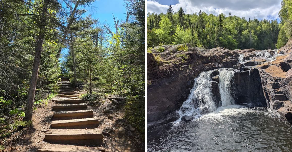
What the Brule River Trail Actually Looks Like

The main trail follows the Brule River upstream through a forest that feels genuinely wild. Spruce, fir, and birch crowd the path on both sides, and the river stays close enough that you can hear it almost the entire way.
The ground is rooted and rocky in places, so solid footwear matters.
The round trip to Devil’s Kettle runs roughly two miles, but calling it an easy hike would be misleading. There are stretches of relatively flat walking near the start, but the trail gets more demanding as you approach the falls.
Wooden staircases with around 175 to 200 steps drop you down toward the water, and those same stairs greet you again on the way back up.
Rest benches are placed along the route at thoughtful intervals, which tells you the park designers knew exactly what they were asking of visitors. Take the breaks, enjoy the river views, and pace yourself.
The Upper Falls: The Overlooked Reward

Most people rush straight past the upper falls to get to Devil’s Kettle, which is understandable, but the upper falls deserve a proper stop. The river spills wide and forceful over dark volcanic rock in a cascade that would be the headline attraction at almost any other park.
The water catches the light differently depending on the time of day, and in the morning hours the mist and the filtered sunlight create a scene that feels almost cinematic. Standing at the overlook with the river roaring below genuinely does carry that Pacific Northwest energy that surprises so many first-time visitors.
The upper falls also tend to be less crowded than the Devil’s Kettle viewing area, so you get more time and space to actually absorb what you are looking at. Bring a wide-angle lens if you carry a camera, because the full width of the cascade is worth capturing.
Devil’s Kettle: The Waterfall That Swallows a River

Here is where things get genuinely strange. The Brule River splits around a massive chunk of volcanic rhyolite, and the right fork drops about 50 feet into a pool below in a classic waterfall.
The left fork pours into a deep pothole in the rock and disappears completely.
Nobody has ever confirmed where that water resurfaces. Researchers have poured dye into the pothole and tracked ping pong balls, and none of it has turned up in any identifiable downstream location.
A 2017 study suggested the water likely rejoins the river through fractures in the rock below the surface, but the mystery still draws visitors who want to see it for themselves.
Getting close to the kettle is possible from the viewing area, but the rocks are slippery and the current is deceptively strong. Admire it from a safe distance, take your photos, and let the strangeness of the place settle in properly before you head back.
Why the Forest Feels Like the Pacific Northwest

Minnesota does not usually get compared to Oregon or Washington, but this particular corner of the state earns the comparison honestly. The forest inside the park is dominated by black spruce, balsam fir, white birch, and cedar, and the canopy stays dense enough that the light underneath is perpetually soft and green-filtered.
The Brule River adds constant sound and moisture to the air, and when fog rolls in off Lake Superior in the mornings, the whole park takes on a moody, rain-forest quality that stops people mid-trail just to look around. The rocks along the riverbank are often draped in moss, and the exposed volcanic formations give the landscape a dramatic, ancient texture.
This is not the flat, lake-dotted Minnesota that most people picture. It is steep, forested, and geologically interesting in ways that reward slow, attentive walking rather than a quick in-and-out visit.
The Staircase Situation: What to Actually Expect

Let’s be direct about the stairs, because they catch a lot of people off guard. The descent to the Devil’s Kettle viewing area involves somewhere between 175 and 200 wooden steps, built into the hillside in sections with platforms and benches between them.
Going down feels manageable. Coming back up is where people reassess their life choices.
The stairs are well-constructed and have solid handrails, so they are not dangerous in dry conditions. Wet weather changes that calculus significantly, and the wooden surfaces can get slick after rain.
Hiking boots with real grip are not optional here, they are the difference between a confident climb and an anxious one.
Children and older adults can absolutely make this hike, but it helps to set honest expectations before you start. The views at the bottom are worth every step, and the benches along the way give you a genuinely good reason to slow down and look at the river.
Camping at the Park: A Quiet, Spacious Option

The campground at this park operates on a different frequency than the big, crowded sites you find closer to Duluth. Sites are spread out and surrounded by enough trees that you genuinely feel separated from your neighbors.
The overall vibe leans toward quiet and self-sufficient rather than amenity-packed.
Shower facilities are available and have been kept clean and functional, which is a detail that matters after a long day of hiking. Dumpsters and recycling stations are accessible without a long walk from most sites.
The campground closes for winter, so plan accordingly if you are visiting outside the summer and early fall window.
Bringing your own water supply or a good filter is a practical move, since the park’s water situation can be limited depending on the time of year. Sites 20 and 21 have been popular choices among repeat visitors for their spacing and tree cover.
Reserve early for summer weekends.
Trout Fishing on the Brule River

The Brule River is not just a scenic backdrop for hikers. It holds a reputation among anglers in northern Minnesota as a solid trout stream, and the stretch running through the park offers access that most fishing spots along the North Shore simply cannot match.
Brook trout and brown trout are the primary targets here, and the rocky, cold-water character of the river suits both species well. The river’s clarity and current make reading the water a rewarding challenge rather than a guessing game.
Early morning and late evening are the most productive windows, as the fish tend to go quiet in the midday heat.
A valid Minnesota fishing license is required, and regulations apply to specific stretches of the Brule, so checking the current DNR rules before you wet a line is worth doing. The combination of good fishing and dramatic scenery makes this river genuinely hard to leave once you are in it.
The Superior Hiking Trail Connection

The Superior Hiking Trail runs directly through Judge C.R. Magney State Park, which means the park serves as more than a single-destination stop.
For thru-hikers and long-distance backpackers working their way along the North Shore, this park is a key waypoint on a trail that stretches nearly 310 miles from Jay Cooke State Park to the Canadian border.
Day visitors can access sections of the Superior Hiking Trail from the trailhead parking area and add mileage to their outing beyond the standard Devil’s Kettle route. The trail here is well-marked and maintained, though the terrain stays rugged enough to keep things interesting.
Elevated viewpoints along this stretch offer some of the broader scenic payoffs that reward hikers who push a little further.
If you have only done the waterfall hike before, spending a few extra hours on the Superior Hiking Trail section through the park is a genuinely different experience that shows off a wider slice of the landscape.
Best Times to Visit and What to Expect Each Season

Summer brings the most visitors and the fullest version of the park experience, with the campground open, trails dry, and the river running strong. July and August weekends fill the parking lot early, so arriving before 9 a.m. genuinely changes how your visit feels.
Fall is the season that makes the North Shore famous, and the forest inside the park turns into something that looks almost theatrical between mid-September and mid-October. The birch and maple color against the dark spruce creates a contrast that photographs well and looks even better in person.
Spring brings high water and powerful waterfall flow, which is dramatic and worth seeing, but trail conditions can be muddy and unpredictable. Winter keeps the park open for day use, but the campground closes and the entrance road may not be plowed immediately after snowfall.
Layer up and bring traction devices if you visit between December and March.
Practical Tips Before You Go

A few things will make your visit run noticeably smoother. Purchase your daily vehicle permit online before you arrive, because the parking lot fills quickly and fumbling with the sign-up process after a long drive is an avoidable frustration.
The DNR website handles permits cleanly and the process takes about three minutes.
There are no restrooms near the falls themselves, so use the facilities at the trailhead before you head out. Bring more water than you think you need, especially in warm months, because the hike back up those stairs is more demanding than the distance suggests.
Trekking poles help on the return climb and are worth throwing in the car.
Cell service is limited in the park, so download an offline map or grab a paper trail map at the trailhead. The park address is 4051 MN-61, Grand Marais, MN 55604, and it is easy to find right off Highway 61 heading north from Grand Marais.


