Southern Indiana is not exactly the first place most people think of when they picture federal wilderness land. Yet tucked inside the rolling hills of Lawrence County sits a forest that quietly holds the title of Indiana’s only national forest and its only federally designated wilderness area.
This national forest stretches across roughly 200,000 acres and offers more than 260 miles of trails for hikers, backpackers, and horseback riders. It has hoodoo rock formations, cliff-lined hollows, lake shores, fire lookout towers, and campgrounds that range from fully equipped to completely off-grid.
For a state better known for cornfields than canyon walls, this place genuinely surprises people. Whether someone drives an hour from Indianapolis or five hours from another state, the forest delivers the kind of quiet, trail-heavy outdoor experience that is hard to find anywhere else in the Midwest.
The Charles C. Deam Wilderness: Indiana’s Only Federal Wilderness

Most people do not realize that Indiana has a federally designated wilderness area at all, but Charles C. Deam Wilderness changed that when Congress established it in 1982.
Named after Indiana’s first state forester, the wilderness covers roughly 13,000 acres within the Hoosier National Forest.
What makes a federal wilderness different from a regular forest trail system is the level of protection it carries. No motorized vehicles, no mechanized equipment, and minimal human infrastructure are allowed inside its boundaries.
The land is managed to remain as wild and undisturbed as possible.
The wilderness sits along the north shore of Lake Monroe, Indiana’s largest reservoir, and that combination of forested ridges and open water creates a backpacking experience that stands apart from anything else in the state. Trails here are rated moderate, making them accessible to hikers who are reasonably fit without requiring elite athletic ability.
Camping directly on the lake shore is one of the biggest draws for overnight visitors.
260 Miles of Trails and What They Cover

Two hundred and sixty miles of trails sounds like a lot until you start mapping out everything the forest actually contains. Hoosier National Forest maintains trail systems for hikers, backpackers, mountain bikers on designated routes, and horseback riders, with some corridors shared between uses and others kept separate.
The trail network connects diverse terrain across the forest’s scattered parcels. Some sections move through dense hardwood forest on relatively flat ground, while others climb limestone ridges and drop into sheltered hollows where creek drainages carve through the rock.
Trail quality and maintenance vary noticeably from one section to another. Some corridors are well-marked and regularly cleared, while others require more navigation skill and comfort with less-defined paths.
Picking up a current trail map from the Bedford headquarters or downloading one from the official USDA Forest Service website before heading out is strongly recommended. The forest’s website at fs.usda.gov/hoosier carries updated information on trail closures and conditions throughout the year.
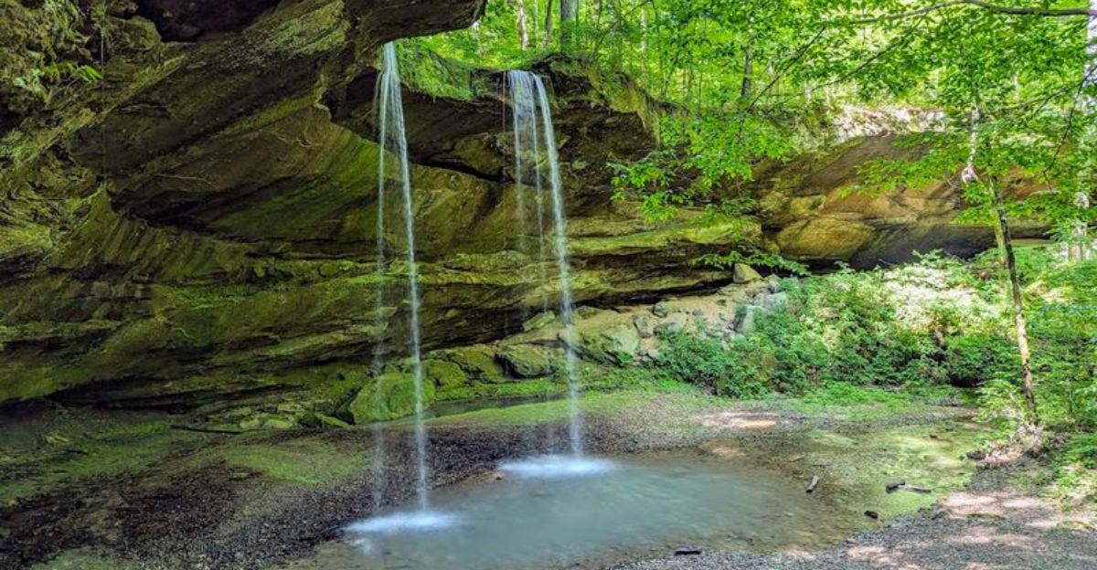
Hemlock Cliffs: The Forest’s Most Talked-About Hollow

Hemlock Cliffs earns its reputation as one of the most visually striking spots in the entire forest. The area features a loop trail that winds through a sandstone hollow, past overhanging cliff walls, small waterfalls, and rock shelters that look like they belong in a completely different part of the country.
The hollow has a cool, sheltered character that keeps it distinct from the rest of the forest. Ferns carpet the ground near the water, and the cliff walls rise steeply on both sides of the trail, creating a close, enclosed corridor unlike the open ridge hiking found elsewhere in the forest.
The trail at Hemlock Cliffs runs roughly two miles as a loop and is considered one of the more accessible routes in the forest for families and casual hikers. It sits in the Crawford Upland section of the forest in Orange County.
Getting there requires navigating some rural roads, so having GPS or a downloaded map ready before leaving cell service range is a practical move.
Jug Rock and the Hoodoo Formations of Martin County

Jug Rock is the kind of geological feature that makes people stop and stare. Standing about 60 feet tall, it is one of the largest freestanding table rocks east of the Mississippi River, a sandstone pillar with a wider cap balanced on a narrower column, shaped by millions of years of differential erosion.
The formation sits near Shoals in Martin County, adjacent to the Hoosier National Forest boundary. While technically just outside the forest’s managed land, it is consistently recommended alongside the forest as part of any southern Indiana outdoor itinerary.
The nearby Hindostan Falls area adds a second geological feature worth combining into the same day trip. Flat limestone shelves extend across the bed of the White River at that location, creating a natural feature that is rare in the broader region.
Together, Jug Rock and Hindostan Falls represent the kind of specific, hard-to-replicate natural details that make southern Indiana worth the drive for anyone who appreciates geology and outdoor exploration.
Hickory Ridge Fire Lookout Tower: Views From 111 Feet Up

At 111 feet tall, the Hickory Ridge Fire Lookout Tower offers something genuinely rare in Indiana: a panoramic view above the tree canopy. The tower stands in the Brown County section of the forest and has become a popular destination for anyone wanting to see the fall foliage from a perspective that ground-level trails simply cannot provide.
Fire lookout towers were once a standard tool for early wildfire detection across national forests. Many have been decommissioned and torn down over the decades, making the ones that remain standing genuine historical landmarks worth preserving.
Climbing the tower requires a reasonable comfort level with heights, as the structure is open-sided and the stairs are steep. The climb itself is straightforward for most adults and older children.
Fall is the most popular time to visit, when the hardwood canopy across the surrounding hills turns color and the elevated view makes the full scale of the forest visible in a way that no trail map can fully communicate.
Lake Monroe: Boating, Fishing, and Shoreline Camping

Lake Monroe is Indiana’s largest reservoir, and a significant portion of its northern shoreline falls within or adjacent to Hoosier National Forest land. That connection between open water and managed forest creates outdoor opportunities that neither resource could offer alone.
Fishing draws a consistent crowd to the lake throughout the warmer months. Bass, crappie, catfish, and bluegill are among the species regularly caught in Monroe’s waters.
Boating is popular as well, with multiple launch ramps providing access to the main body of the lake.
For backpackers camping in the Charles C. Deam Wilderness, reaching a campsite directly on the Lake Monroe shoreline is one of the most rewarding experiences the forest offers.
Waking up next to the water after hiking in through the wilderness trail system gives the trip a remote, earned quality that developed campgrounds simply do not replicate. The combination of wilderness trail access and a large, open lake makes this section of the forest particularly versatile for multi-day outdoor trips.
Campgrounds Across the Forest: From Full Hookups to Primitive Sites

Hoosier National Forest maintains a range of campgrounds that cover nearly every style of camping. On one end of the spectrum, developed campgrounds like Indian-Celina Lakes offer paved sites, shower facilities, and amenities that make longer stays comfortable for RV travelers and families with younger children.
On the other end, primitive options like Saddle Lake campground bring the cost down to around five dollars per night. Sites there include a picnic table, a fire ring, and access to vault toilets, but no electricity and no potable water.
It is a straightforward trade: fewer amenities, lower cost, more quiet.
Dispersed camping is also permitted in many areas of the forest, allowing visitors to camp away from designated sites entirely. Berry Ridge Road is one area that gets mentioned frequently for dispersed camping, and several horse camps across the forest offer free sites with toilet facilities for equestrian visitors.
The variety means the forest can accommodate a solo backpacker and a family in an RV during the same weekend.
Horseback Riding Trails and Equestrian Facilities

Horses have a long history in southern Indiana, and the Hoosier National Forest keeps that tradition alive with dedicated equestrian trail systems that run through multiple sections of the forest. Miles of horse trails wind through the same hardwood ridges and creek bottoms that foot traffic trails cover, but on routes specifically designed to handle hoof traffic.
Horse camps scattered across the forest give equestrian visitors a practical base of operations. Blackwell Horse Camp is one of the better-known options, offering free camping with toilet facilities in a setting designed around the needs of riders and their animals.
The combination of overnight camping with horses and long-distance trail riding makes the Hoosier National Forest one of the more horse-friendly destinations in the Midwest. Riders who want multi-day trips can string together enough trail miles to make it a genuine expedition rather than just a day ride.
Checking current trail conditions with the forest service before trailering horses in is always a worthwhile step, as seasonal closures can affect specific corridors.
Spelunking and Cave Exploration in the Limestone Country

Southern Indiana sits on top of a massive limestone karst system, and that geology creates cave opportunities throughout the region surrounding Hoosier National Forest. The same rock formations that produce the cliffs at Hemlock Cliffs also produce underground caverns accessible to those who know where to look.
Spelunking within and around the forest draws a specific type of outdoor enthusiast, one who prefers exploring underground passages over following marked surface trails. The activity requires preparation, appropriate gear, and ideally some prior experience or guidance from someone familiar with the specific cave systems in the area.
The broader region around the forest includes Spring Mill State Park, which contains a well-developed cave system open for guided tours. That park sits close enough to the forest that combining a cave tour there with a hiking or camping day in the national forest makes for a logical two-day itinerary.
The limestone geology of the area makes this corner of Indiana genuinely unique in terms of underground natural features.
Wildlife and the Natural Diversity of the Forest

White-tailed deer are the most commonly spotted large animal in the forest, and their population across southern Indiana is substantial. Wild turkey, red fox, and various bird species round out the wildlife that hikers and campers regularly encounter while moving through the forest’s trail system.
The forest’s mix of habitat types supports a wider range of species than a single vegetation type would. Upland oak-hickory forest, lowland creek corridors, open pond edges, and the Lake Monroe shoreline each attract different animals, making the forest a genuinely diverse environment from a wildlife perspective.
Spring brings visible wildflower blooms across the forest floor, with flowering trees adding color to the hillsides throughout April and May. The spring season is consistently praised as one of the best times to visit for those who want to see the forest at its most active.
Fall foliage season runs a close second in terms of visual appeal, with the hardwood canopy shifting through orange, yellow, and red across the ridgelines.
Geode Hunting and Rockhounding Opportunities

Geode hunting is a legitimate outdoor activity in southern Indiana, and the creek beds and exposed rock formations within and around Hoosier National Forest are among the better places in the state to find them. The limestone geology that defines the region produces geodes with quartz crystal interiors that range from small pocket-sized specimens to larger, more impressive finds.
Creek gravels and eroded hillside exposures are the typical hunting grounds. No specialized equipment is required beyond a hammer, a chisel, and a willingness to get muddy along stream banks.
Identifying promising rocks before cracking them open is part of the skill that regular rockhounds develop over time.
Regulations on collecting natural materials within national forest land do apply, so checking current rules with the forest service before collecting anything is the responsible approach. Personal-use quantities for non-commercial collecting are generally permitted, but commercial collection requires authorization.
The activity appeals to families with children as much as it does to dedicated collectors, making it a practical addition to any camping trip in the area.
Best Times to Visit and Seasonal Considerations

Fall and spring are the two seasons that consistently draw the strongest praise from people who spend time in the forest. Fall foliage typically peaks in mid-to-late October, when the hardwood canopy across the ridges turns color and the cooler temperatures make long hiking days much more comfortable than summer allows.
Summer visits are entirely possible but come with trade-offs. The forest canopy becomes extremely dense by July, which blocks distant views along trail corridors and traps heat and humidity at ground level.
Hikers planning summer trips should carry significantly more water than they think they will need, as the exertion level on longer routes tends to be higher than the relatively modest elevation changes suggest.
Winter offers a quieter, more solitary experience for those comfortable with cold-weather camping and hiking. Trail traffic drops considerably after October, and the bare canopy actually opens up views through the forest that summer completely obscures.
Spring wildflower season, running from late March through May, is a consistently underrated time to visit the forest.
The Indiana-Celina Lakes Area and the Loop Trail

The Indian-Celina Lakes area in the southern section of the forest offers one of the more complete multi-day hiking experiences the forest provides. The loop trail that circles both lakes covers roughly 10 to 14 miles depending on the route taken, passing through established campsites along the south side of the loop and more remote terrain on the north side.
The south slope campground near Indian-Celina Lakes is a developed facility with shower rooms, water access, and paved pull-in sites. The campground sits in a quiet setting away from major roads, and the combination of developed amenities with direct trail access makes it a practical base for day hikes or the start of a multi-day loop.
The loop trail itself moves through classic southern Indiana hardwood forest and passes close to the lake shores at multiple points. Trail markers are generally reliable on this route, making it a reasonable choice for hikers who are newer to backcountry navigation but want more than a simple out-and-back day hike experience.
Planning Your Trip: Practical Tips Before You Go

A few practical details make a Hoosier National Forest trip go more smoothly. Cell service is unreliable across large portions of the forest, so downloading offline maps before leaving home is not optional, it is genuinely necessary for navigating the forest’s scattered parcels and rural access roads.
Water sources exist throughout the forest, but none should be consumed without treatment. Carrying a filter or purification tablets on any hike longer than a couple of hours is standard practice.
Developed campgrounds with potable water are available, but primitive and dispersed sites have none.
The forest headquarters at 811 Constitution Ave in Bedford is open Tuesday through Thursday from 8 AM to noon. Stopping there before heading into the backcountry gives travelers access to current trail conditions, fire restrictions, and any temporary closures that online sources may not have updated yet.
The official USDA Forest Service website at fs.usda.gov/hoosier is the most reliable digital resource for planning, with downloadable maps and current news about the forest available year-round.
Where the Forest Begins: Location and Headquarters

The administrative heart of Hoosier National Forest sits at 811 Constitution Ave, Bedford, IN 47421, in the rolling limestone country of southern Indiana. Bedford serves as the gateway city for anyone planning a trip, and the forest headquarters is a practical first stop for maps, permits, and current trail conditions.
The forest itself does not begin and end in one continuous block. It spreads across nine counties in southern Indiana, with land parcels scattered throughout the region.
That patchwork layout means different entry points serve different parts of the forest, so knowing which section to target before arriving saves a lot of driving time.
The headquarters office operates on a limited schedule, open Tuesday through Thursday from 8 AM to noon, and is closed the rest of the week. Planning around those hours ensures a traveler can get the most current information directly from forest staff before heading out on the trails.


