Tucked away in north-central Massachusetts, a cascading series of waterfalls has been carving through forested land for centuries, long before most people knew it existed. What makes this spot particularly compelling is its double life: it once hummed with industrial activity, powering mills that kept a small rural community running, and today it stands as a protected natural preserve open to hikers, nature lovers, and anyone who appreciates a good waterfall.
The five-tiered cascade drops through 46 acres of woodland, and the trail to reach it is short enough for kids but rewarding enough for seasoned hikers. This is the kind of place that makes you wonder why more people have not heard about it, and by the end of this article, you will have every reason to plan a visit.
The Mill History That Most Hikers Walk Right Past

Most people who visit Doane’s Falls today are focused on the water, the trail, and the trees. Very few stop to think about the industrial past that once defined this exact stretch of Lawrence Brook.
The falls were historically used to power grist mills and sawmills during the 18th and 19th centuries. The fast-moving water provided reliable mechanical energy in an era when rivers and streams were the engines of rural New England economies.
Stone walls still zigzag through the surrounding woods, silent reminders of the farming and milling operations that once shaped this landscape.
Those walls were built by hand, likely by early settlers who cleared the land for agriculture and industry. Seeing them today, half-buried in moss and leaf litter, gives the hike an unexpected layer of history that most trail maps do not bother to explain.
The falls outlasted every mill that once depended on them.
How the Land Became a Protected Preserve

The transition from working industrial land to protected natural preserve did not happen overnight. Doane’s Falls is now managed by The Trustees of Reservations, a Massachusetts-based nonprofit land conservation organization that has been protecting open spaces across the state since 1891.
The Trustees acquired this parcel as part of a broader effort to preserve the Tully Lake region, which includes wetlands, forests, and river corridors in Worcester County. The 46-acre preserve was set aside specifically because of its ecological and scenic value, protecting the waterfall and the surrounding forest from development.
Conservation efforts in this region have helped maintain clean water in the Tully Brook system, which feeds into the Millers River. The fact that the falls still flow with impressive volume, even during drought conditions, speaks to the health of the broader watershed that the preserve helps protect.
Stewardship here is taken seriously, and it shows in the condition of the land.
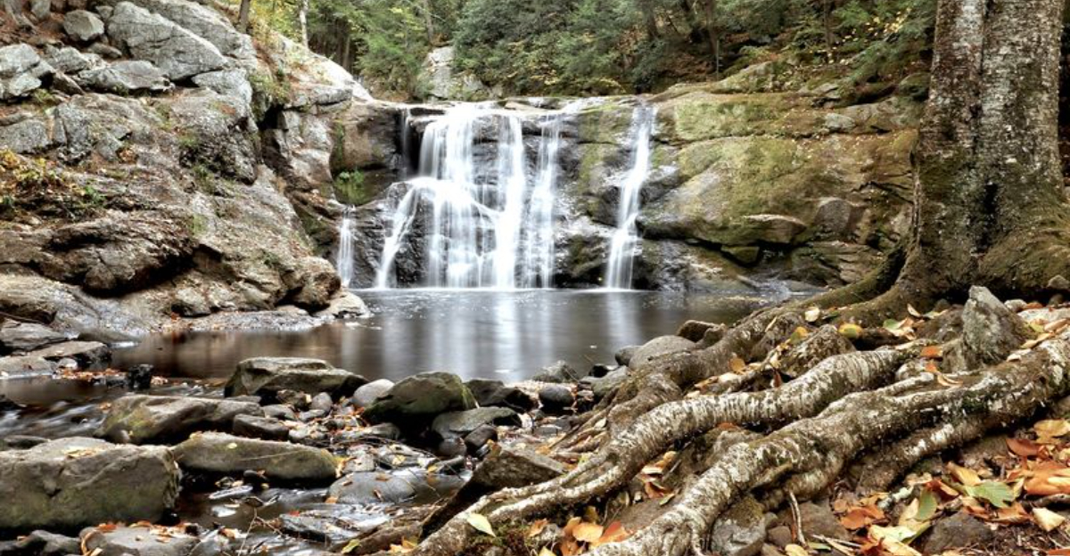
Five Falls, One Trail, and a Surprisingly Short Walk

One of the most pleasant surprises at Doane’s Falls is how quickly the reward arrives. The first waterfall is visible from the parking area, which means even people who cannot manage a long hike get to experience the falls without much effort.
The main trail runs about 1.25 miles one way, following Lawrence Brook downstream through a series of five distinct drops. The trail descends alongside the cascade, offering changing views at each level.
Some sections are steep and require careful footing, particularly when wet leaves cover the path in autumn.
The full series of falls includes drops estimated at 20 to 30 feet for the largest tiers, and the cumulative effect of walking past each one builds a satisfying sense of progression. Hikers who complete the full trail eventually reach a point where the path meets a road, near a kayak launch site and a ranger station with restroom facilities.
Short does not mean lacking here.
What the Water Actually Does Year-Round

Lawrence Brook feeds Doane’s Falls with a consistency that surprises many first-time visitors. Even during documented drought periods, the flow at the falls has remained noticeably active, which points to the deep groundwater reserves and forested watershed that sustain it.
Winter visits reveal a completely different character. Ice formations build up along the rock faces, and the contrast between moving water and frozen edges creates a striking visual that warm-weather visits simply cannot replicate.
Hikers who have made the trip in December report that the falls look entirely different under winter conditions, and that the lack of crowds makes the experience feel more personal.
Spring brings the highest water volumes, when snowmelt pushes the brook to its fullest flow. Summer settles the water into a steadier rhythm, and autumn layers the scene with falling leaves that collect in the pools below each drop.
Each season at Doane’s Falls offers something the others cannot.
The Foliage Factor That Draws Fall Hikers

Worcester County has a strong claim to some of the best fall foliage in Massachusetts, and Royalston sits right in the middle of that argument. The forest surrounding Doane’s Falls includes a dense mix of hardwoods that turn brilliant shades of red, orange, and yellow from late September through mid-October.
The combination of moving water and peak foliage creates conditions that draw photographers and casual hikers alike. The trail does become harder to follow when leaves cover the ground, as the path markings are not always easy to spot.
Staying on the main trail is recommended, particularly near the middle section where some hikers have been tempted to scramble down to the water’s edge on unmarked routes.
Weekday visits during foliage season are significantly quieter than weekends, when the small parking area fills up fast. Arriving early in the morning on a weekday gives hikers the best chance of having the trail largely to themselves during peak color season.
Trail Difficulty and Who Can Actually Handle It

The trail at Doane’s Falls gets described differently depending on who is doing the describing. For younger children and adults in good physical condition, the hike is accessible and manageable.
For older adults or anyone with limited mobility, certain sections near the steeper drops require more caution.
The path closest to the parking area is essentially flat and accessible, which makes the first waterfall reachable for almost anyone. Further down the trail, the terrain becomes uneven, with rocky sections and root-covered ground that demand steady footing.
Traction footwear is consistently recommended, especially in wet or icy conditions.
Hiking poles help significantly on the steeper descent sections, and the climb back up from the lower falls is the most physically demanding part of the route. Flip-flops and casual shoes have caused problems for unprepared visitors in the past.
The trail rewards those who dress appropriately and take their time rather than rushing through the descent.
Parking, Access, and the Small Lot Situation

Parking at Doane’s Falls is genuinely limited, and that single fact shapes the experience more than almost anything else. The main lot near the upper falls holds roughly eight cars, and a secondary area nearby offers space for about five more vehicles.
On busy weekends, both fill up quickly.
The road leading to the preserve has wider shoulders in places, which allows for additional roadside parking when the lots are full. This is a common workaround on peak days, though it requires walking a short distance to the trailhead.
Arriving early, particularly on weekends during foliage season or summer, is the most reliable strategy for securing a spot.
Weekday visits are consistently described as much quieter, with the parking situation rarely becoming an issue outside of peak periods. The preserve does not charge an entry fee for Trustees of Reservations members, and non-members can access the trail as well.
The limited parking keeps crowds naturally in check.
Wildlife, Mushrooms, and the Forest Floor

The 46 acres surrounding Doane’s Falls support a surprisingly rich variety of forest life. The hardwood and mixed forest canopy creates layered habitat for birds, small mammals, and an impressive range of fungi that appear along the trail, particularly in late summer and early fall.
Mushroom diversity at this preserve has caught the attention of nature enthusiasts who visit specifically to document the different species growing on logs, stumps, and the forest floor. Mid-September tends to produce the widest variety, with multiple distinct species visible within a short stretch of trail.
Beaver activity has been documented along the lower sections of Lawrence Brook, where the stream winds through a red maple swamp beyond the main falls area. Paddlers who launch from the meadow near the ranger station sometimes encounter beaver dams as the waterway narrows and meanders through wetland habitat.
The forest here functions as a complete ecosystem, not just a backdrop for the waterfall.
A Spot That Has Passed Between Generations

Some places earn their reputation not through marketing but through the quiet act of being passed down from one generation to the next. Doane’s Falls is that kind of place.
Families return here year after year, and the story of being brought here as a child only to return with your own children is one that comes up repeatedly in connection with this preserve.
The falls have a quality that makes them stick in memory. Children who visit tend to remember the water, the rocks, and the scale of the drops in a way that more manicured attractions rarely produce.
The relative wildness of the setting, with its uneven trail and roaring water, creates a more lasting impression than a paved park path ever could.
That generational loyalty has kept the preserve from becoming overcrowded, since most people who know about it treat it with a kind of quiet protectiveness, preferring to share it carefully rather than broadcast it widely.
Practical Tips Before You Make the Drive

A few practical details can make the difference between a smooth visit and a frustrating one at Doane’s Falls. Traction footwear is the single most consistent recommendation from people who have hiked the trail, particularly on wet days or during leaf-covered autumn conditions.
The rock surfaces near the falls can be slick.
Bug spray is worth packing, especially for the walk-in portion of the trail during summer months. Mosquitoes are active in the wooded sections between the parking area and the first waterfall, and being prepared makes the approach considerably more comfortable.
The preserve does not have extensive signage along the trail, so staying aware of the path is important, especially where the route becomes less defined near the middle falls section. Cell service in the area can be unreliable, so downloading an offline map before arriving is a smart move.
The drive from major Massachusetts cities ranges from 90 minutes to two hours, making this a solid half-day trip.
Where Exactly This Waterfall Calls Home

Long before GPS made every trail findable, Doane’s Falls was the kind of place you only knew about if someone local pointed you in the right direction. The preserve is located in Royalston, MA 01331, a small rural town in Worcester County in north-central Massachusetts, not far from the New Hampshire border.
The area sits within the Tully Brook watershed and is managed as a protected forest preserve. The town of Royalston itself has a population of just over a thousand people, which explains why this spot has stayed relatively uncrowded compared to more publicized natural attractions in the state.
The nearest larger town is Athol, which gives travelers a useful landmark when navigating the winding back roads of the region. Getting there requires a bit of a drive, but the surrounding countryside makes the journey worthwhile on its own terms.


