Tucked away in the hill towns of western Massachusetts, there is a gorge carved by the Westfield River that most people drive right past without ever knowing it exists. High rock walls, rushing water, and the crumbling stone remains of a bridge that once carried travelers along the old Boston Post Road make this place unlike anything else in the region.
The gorge is managed by The Trustees of Reservations and sits along River Road in West Chesterfield, offering free access to one of the most geologically striking natural areas in the Pioneer Valley. Whether you are a hiker, a history buff, or just someone who appreciates a good trail that does not require a four-hour drive, this spot rewards every kind of visitor with something genuinely worth seeing.
The Old Post Road Bridge That Started It All

The most historically compelling feature of Chesterfield Gorge is not the gorge itself but the remnants of a bridge that once carried travelers along the old Boston Post Road across the Westfield River. These stone abutments still stand at the edge of the gorge, weathered but intact, as a quiet reminder of a time when this remote stretch of Massachusetts was actually a main travel corridor.
The Boston Post Road was one of the most important routes in colonial New England, connecting Boston to communities further west and eventually south. A bridge at this crossing would have been a critical link for mail carriers, merchants, and settlers moving through the region during the 17th and 18th centuries.
The fact that these abutments survived at all is remarkable given the age of the structure and the force of the river below. They are a tangible piece of early American infrastructure hiding in plain sight along a quiet forest trail.
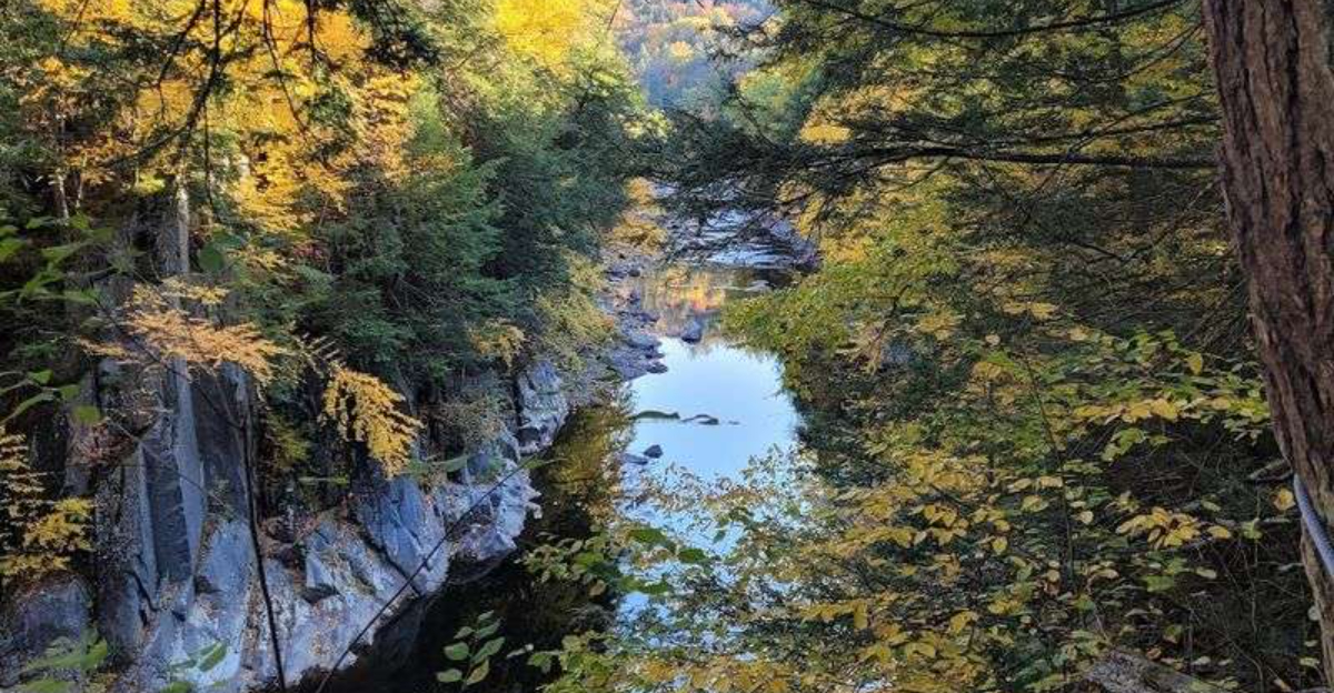
The Geology Behind Those Towering Rock Walls

The rock walls at Chesterfield Gorge are not just tall, they are geologically fascinating. Basalt columns rise directly out of the water, and the riverbed is dotted with potholes, which are circular depressions worn into the rock over thousands of years by swirling sediment and water pressure.
These formations took an extraordinarily long time to develop and represent the kind of geological record that most people only see in textbooks. The gorge itself stretches roughly 800 feet in length, and within that relatively short distance, the rock faces display an impressive variety of textures and formations that reward anyone who takes the time to look closely.
Basalt is a volcanic rock, and its presence in this part of Massachusetts speaks to the ancient geological history of the region, long before it became a quiet corner of New England. The gorge functions almost like an open-air geology classroom, and no prior knowledge is needed to appreciate what is on display.
What the Trail Actually Looks Like

The main trail at Chesterfield Gorge follows a wide, well-maintained dirt road that runs parallel to the Westfield River. The path is easy to navigate and does not require any advanced hiking experience, though the terrain near the gorge rim does involve some uneven footing that calls for sturdy shoes.
The trail connects to the Gilbert A. Bliss State Forest, which opens up the possibility of much longer loops.
A 6 to 7 mile loop through the combined trail network takes roughly three and a half hours at a comfortable pace, making it a solid half-day outing without being physically demanding.
For those who prefer a shorter visit, the gorge overlook is reachable within a few minutes of leaving the parking area. The trail is mostly shaded by the surrounding forest canopy, which helps keep conditions comfortable during warmer months.
Dogs are welcome on leash, and the wide dirt road section is genuinely popular with dog walkers.
Getting Down to the Water

One of the more appealing aspects of Chesterfield Gorge is that the water is actually accessible. At several points along the trail, the terrain allows hikers to carefully descend to the riverbank and get close to the Westfield River without any technical climbing required.
The river bottom features small rock beaches and even a sand beach that appears downstream from the gorge during mid-spring and summer. The water level drops enough in summer to allow wading, and the riverbed can be crossed on foot with water shoes when conditions are right.
Small waterfalls and creek runoffs feed into the main channel at various spots, creating natural pools that are popular with those who want to cool off during warmer months. The water runs cold even in summer, which is worth knowing before committing to a full wade.
Getting close to the river adds a completely different dimension to the visit compared to just viewing it from the trail above.
Winter at the Gorge Is a Completely Different Story

Most natural areas in New England are busiest in fall foliage season, but Chesterfield Gorge has a strong following among winter outdoor enthusiasts. The property is open year-round, and the trails are well-suited for snowshoeing and cross-country skiing when conditions allow.
The wide dirt road that runs along the river becomes a natural ski trail in winter, and the flat to gently rolling terrain makes it accessible to beginners. The color of the river water in winter is notably different from other seasons, taking on a deeper, more intense quality that stands out against the snow and bare rock.
Ice formations build up along the rock walls of the gorge during cold snaps, creating a visual display that is hard to replicate at any other time of year. The parking lot is not plowed in winter, so visitors need a vehicle that can handle unpaved snowy conditions.
Appropriate footwear is essential on the icy sections near the gorge rim.
Who Manages This Land and Why It Matters

Chesterfield Gorge is a property of The Trustees of Reservations, a Massachusetts-based nonprofit that has been protecting open land and historic sites since 1891. The organization manages more than 120 properties across the state, and Chesterfield Gorge is one of its western Massachusetts holdings.
The Trustees model is built around public access combined with conservation stewardship, which is why the gorge remains free to visit and well-maintained without being overdeveloped. There are no admission fees, no concession stands, and no interpretive centers cluttering up the trailhead.
The property is kept simple by design.
The organization also runs guided tours of the gorge on occasion, which provide historical and geological context that enhances the visit considerably for those who prefer a structured experience. Information about the property, including trail maps and seasonal updates, is available through The Trustees website at thetrustees.org/place/chesterfield-gorge.
Supporting organizations like The Trustees through membership or donation helps ensure that places like this remain protected for future use.
How the Gorge Connects to Gilbert A. Bliss State Forest

The trail network at Chesterfield Gorge does not end at the gorge itself. The reserve trails connect directly to Gilbert A.
Bliss State Forest, significantly expanding the options for hikers who want more mileage or a longer adventure through western Massachusetts woodland.
The combined trail system allows for loops ranging from a short 1 to 2 mile walk to a more substantial 6 to 7 mile outing, depending on which routes are chosen. The terrain through the state forest adds elevation changes and a different character compared to the flatter river road section near the gorge.
This connectivity between a Trustees property and a state forest is relatively uncommon and makes the Chesterfield Gorge area a more versatile destination than its modest trailhead would suggest. Trail conditions vary seasonally, and the state forest sections can be muddier in spring.
Carrying a trail map or downloading the route in advance is a practical step before attempting the longer loop through both properties.
The Quiet Factor That Keeps Regulars Coming Back

Part of what makes Chesterfield Gorge appealing to its regular visitors is how uncrowded it stays. The location in rural Hampshire County, the lack of cell service, and the absence of major highway signage all contribute to a natural filter that keeps the crowds at a manageable level even on weekends.
The gorge has preserved much of its original character precisely because it has not become an overrun destination. The trail does not show the kind of heavy foot traffic erosion that plagues more famous natural areas in New England, and the surrounding forest feels genuinely intact rather than worn down by overuse.
That low-key quality is something long-time visitors actively appreciate and want to protect. The general ethos among regular users leans toward leave-no-trace principles, carry-out trash policies, and minimal impact behavior.
It is the kind of place where the culture of the regular visitors actively helps preserve the experience for everyone who comes after them.
Mountain Biking the Gorge Trails

Chesterfield Gorge is not exclusively a hiking destination. The wide dirt road and connecting trails make it a legitimate mountain biking spot, and the route out to the dam and back is a popular ride among cyclists who know about it.
The biking terrain is described as fast and fun, with a natural surface that rewards riders who are comfortable on unpaved trails. Some sections have become a bit overgrown, which adds a technical element that more experienced riders tend to enjoy.
The ride to the dam covers a solid distance and passes through the same riverside scenery that makes the gorge appealing on foot.
The property does not have dedicated mountain bike infrastructure like berms or jumps, so the appeal here is purely trail riding through a natural setting rather than a skills park experience. Riders share the trail with hikers, which means speed and awareness are both important.
Early morning weekday rides tend to offer the most uninterrupted time on the trail.
Fishing the Westfield River at the Gorge

The Westfield River running through Chesterfield Gorge is a designated catch-and-release fishing area, which makes it a draw for anglers who want a scenic and productive stretch of river without the pressure of a heavily fished public access point.
The river supports a healthy fish population, and the varied terrain along the banks, including rock shelves, pools, and riffles, creates the kind of habitat that fish favor. Access to the water at multiple points along the trail means anglers can cover different sections of the river during a single visit without backtracking.
Catch-and-release rules apply here, which is consistent with the conservation mission of The Trustees of Reservations. Fishing gear and licensing requirements follow standard Massachusetts regulations, so checking current state rules before heading out is a practical step.
The combination of a quality fishing spot inside a protected natural area with free parking and no crowds makes this one of the more underappreciated fishing destinations in western Massachusetts.
Practical Tips Before You Make the Drive

A few practical details make the difference between a smooth visit and an avoidable frustration at Chesterfield Gorge. The parking area is free and spacious, but it is unpaved and not plowed in winter, so a vehicle with reasonable ground clearance is helpful during snowy months.
No bathrooms or portable facilities are available on site.
Cell service is essentially nonexistent at the gorge, which means downloading a trail map or saving the directions before leaving home is a genuinely useful step. The Trustees website has current trail information and any seasonal closures or updates worth checking before the drive out.
Bug spray is recommended during late spring and early summer when insects are active along the river corridor. Sturdy footwear with ankle support is the right call for the rocky sections near the gorge rim and the riverbank.
All trash must be carried out, and the property rules ask that dogs remain on leash at all times throughout the trail network.
Why This Gorge Deserves More Attention Than It Gets

Chesterfield Gorge sits in a part of western Massachusetts that does not get the same tourist attention as the Berkshires to the south or the Connecticut River Valley to the east. That relative obscurity is actually one of its strongest qualities, but it also means the gorge remains genuinely underappreciated on a regional scale.
The combination of geological features, colonial history, river access, year-round trail use, wildlife, and a connection to a larger state forest trail network makes this a destination with unusual depth for a property of its size. Most visitors who make the trip once tend to return, which says something about the lasting quality of the experience.
The old bridge abutments alone are worth the drive for anyone with even a passing interest in early American history. Add the towering basalt walls, the rushing river below, and the genuine quiet of a spot that has not been loved to exhaustion, and what remains is one of the most rewarding natural areas in all of western Massachusetts.
Where Exactly This Hidden Gorge Sits

Chesterfield Gorge is located at River Road, West Chesterfield, MA 01084, in Hampshire County in the hill towns of western Massachusetts. The property is managed by The Trustees of Reservations, one of the oldest land conservation organizations in the United States.
The gorge sits in a rural stretch of the Pioneer Valley, roughly between the towns of Northampton and Keene, New Hampshire, making it a reasonable day trip from a wide range of locations in the region. The parking area along River Road is spacious, unpaved, and free to use, which is a genuine bonus in a state where trailhead parking often comes with a fee or a permit requirement.
There is no cell service on site, which adds to the off-the-grid quality of the experience. No bathrooms are available at the trailhead, so planning ahead is strongly recommended before making the trip out to this quiet corner of Hampshire County.


