There is a narrow strip of land jutting into the Mississippi River in Memphis, Tennessee, that holds one of the most unusual outdoor attractions in the entire South. It has a scale model of the Mississippi River built right into the ground, a pedestrian skybridge connecting it to downtown, and open views of the river stretching in both directions.
The park has had its ups and downs over the years, but it keeps drawing people back with its quirky mix of history, open space, and genuine riverfront character. Whether you are a first-time visitor or a Memphis local who has not made the trip in a while, this park offers something that is genuinely hard to find anywhere else in Tennessee.
The Story Behind the Island

Mud Island did not always exist. The peninsula formed naturally in the early 20th century as silt and sediment built up along the northern edge of downtown Memphis.
A U.S. Army Corps of Engineers snag boat ran aground there in 1910, and the debris helped anchor the growing sandbar into something more permanent.
Over the following decades, the city gradually developed the land. The park as most people know it today opened in 1982, featuring the Mississippi River Museum, the River Walk scale model, an amphitheater, and the monorail tram that carried visitors from downtown to the island.
That opening was a big moment for Memphis, and the park quickly became a popular destination for families, school trips, and tourists passing through the city. Understanding how recently the island came to exist makes the whole place feel a little more remarkable, since it was essentially built from the river itself.
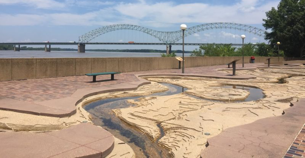
The Mini Mississippi That Stole the Show

The most talked-about feature at Mud Island is the River Walk, a five-block-long scale model of the lower Mississippi River built right into the surface of the peninsula. The model stretches from Cairo, Illinois, all the way down to the Gulf of Mexico, recreating the river’s path, bends, tributaries, and depth changes in accurate detail.
Towns and cities along the river’s route are marked along the way, so walking the model becomes a quiet geography lesson. At full scale, every inch of the model represents roughly one mile of the actual river, which gives you a real sense of how far the Mississippi travels before reaching the Gulf.
When water flows through the model, it follows the same curves and channels as the real river, making it one of the more creative educational installations anywhere in the country. Even without water running through it, the sheer size and detail of the model make it worth the trip on its own.
The Skybridge Walk You Should Not Skip

The skybridge connecting downtown Memphis to Mud Island is one of the more underrated walks in the city. It stretches over the Wolf River Harbor, giving you an elevated view of the water below and the downtown skyline behind you as you make your way across.
The bridge is open during park hours, which generally run from 7 a.m. to 7 p.m., so timing matters if you plan to use it as your main entry point. Arriving close to closing time is something to avoid, since the gate locks promptly and getting stuck mid-bridge is not a situation anyone wants to deal with.
The walk itself takes only a few minutes, but many people slow down to take photos or just stand and watch the river traffic below. Tugboats, barges, and the occasional recreational boat pass through the harbor, turning the bridge into an informal observation deck that most city parks simply cannot offer.
River Views That Frame the Whole Experience

Few places in Memphis put you this close to the Mississippi River with this much open space around you. From the western edge of Mud Island, the river spreads out wide, and on a clear day the Arkansas shoreline is visible across the water.
The views shift depending on where you stand on the peninsula.
From the northern tip, you get a long upstream look at the river as it curves around the city. From the southern end near the Gulf of Mexico pool at the base of the River Walk model, the view opens toward the south with nothing blocking the horizon.
The Memphis skyline frames the eastern side of the island, and the contrast between the modern city buildings and the slow-moving river is one of the more striking visual combinations the park offers. Photographers tend to work the island for hours, and it is easy to understand why once you see how the light hits the water in the afternoon.
The Monorail That Still Sparks Curiosity

The monorail tram that once carried visitors from downtown Memphis to Mud Island is now one of the park’s most talked-about curiosities. The system ran alongside the skybridge and allowed people to ride across the Wolf River Harbor without making the walk on foot, which was especially useful for families with young children or anyone carrying gear.
The tram has been out of service for years, and the idle cars and track have become a visual landmark in their own right. People who spot it for the first time tend to stop and stare, and it has developed something of a cult following among urban exploration enthusiasts.
There is something genuinely interesting about a piece of transit infrastructure frozen in place while the city moves on around it. Whether the monorail ever returns to service is an open question, but for now it stands as a reminder of what Mud Island once was and what it could potentially become again with the right investment.
The Mississippi River Museum

The Mississippi River Museum at Mud Island was designed to tell the full story of the river from its origins in the north to its delta in the south. The exhibits covered the river’s natural history, the cultures that developed along its banks, the commerce it supported, and the events that shaped the communities in its path.
The museum has faced extended closures over the years due to funding challenges and the broader maintenance issues that have affected the park. When it is open, history and geography enthusiasts tend to find it well worth the time, since the level of detail in the exhibits is more thorough than most expect.
The building itself sits at the entrance to the peninsula and serves as the formal gateway to the River Walk and the rest of the park. Checking the current operating status before visiting is a smart move, since hours and availability have changed frequently and the website does not always reflect the most current situation on the ground.
Kayaking on the Mississippi

Kayaking on the Mississippi River from Mud Island is one of the more memorable outdoor activities available in Memphis. The Wolf River Harbor on the eastern side of the island offers calmer water than the main river channel, making it a more accessible option for paddlers who want to be on the water without dealing with heavy river current.
Kayak rentals have been available at the park in the past, though availability has varied depending on the season and the park’s operational status at any given time. Calling ahead or checking current information before planning a paddling trip is the practical approach.
Being on the water at river level gives you a completely different perspective on both the island and the downtown skyline. The Hernando de Soto Bridge looms large from the water, and the scale of everything around you shifts when you are sitting in a kayak rather than standing on the shore looking out.
The Iconic Memphis Sign

At the southern end of the River Walk, where the scale model of the Mississippi River meets its symbolic Gulf of Mexico, stands the large and colorful Memphis sign that has become one of the park’s most photographed spots. The sign is bold, easy to find, and serves as a natural finishing point for anyone who has walked the full length of the model.
It has appeared in countless travel photos and social media posts over the years, and stopping for a picture there has become something of an unofficial tradition for first-time visitors. The sign’s bright lettering stands out against the open sky and the river backdrop, making it a reliable photo opportunity regardless of the time of day.
Beyond its value as a photo stop, the sign marks a genuine geographic moment in the walk. Reaching it means you have symbolically traveled the entire lower Mississippi, from the Illinois border all the way down to the Gulf, which is a satisfying way to finish any visit to the park.
Practical Tips for Your Visit

A few practical details can make the difference between a smooth visit and a frustrating one at Mud Island. The park itself is free to enter, but parking in the nearby lots comes with a fee, so budgeting for that ahead of time is worth doing.
The skybridge closes at 7 p.m., and that cutoff is enforced, so planning your arrival with enough time to explore and return before closing is essential.
The park is generally more active and better maintained during warmer months, and some amenities that are closed in the off-season may be open in summer. Checking the city of Memphis parks website or calling ahead can save a wasted trip if specific features like the museum or the River Walk water flow are important to your plans.
Comfortable walking shoes are a practical necessity since the peninsula is long and most of the interesting features require covering real ground on foot. Bringing water and sunscreen on warm days is also a straightforward recommendation given the open, exposed nature of most of the park.
Why Mud Island Still Matters to Memphis

Mud Island occupies a unique place in Memphis’s identity. There is no other spot in the city that puts you physically in the middle of the Mississippi River while still keeping downtown within walking distance, and that combination is genuinely rare across the entire country.
The park has faced real challenges over the years, from deferred maintenance to extended closures, and the gap between what it once was and what it currently offers is something locals and frequent visitors tend to feel strongly about. The potential is obvious to anyone who spends an afternoon there, and conversations about revitalization and reinvestment have circulated for years.
What keeps people coming back is something the park has always had, regardless of its condition: a location and a concept that are hard to replicate. A scale model of the Mississippi River, a skybridge over the harbor, open river views, and a peninsula that formed from the river itself make Mud Island a place that Memphis, and Tennessee, would be hard-pressed to replace.
Where Mud Island Actually Is

Mud Island River Park sits on a narrow peninsula in the Mississippi River, connected to downtown Memphis, Tennessee, by the famous pedestrian skybridge. The official address places it in Memphis, TN 38103, and it is easy to spot from the riverfront because of its long, flat shape cutting through the water.
The park is close to several downtown landmarks, including the Pyramid arena and the Bass Pro Shops megastore that now occupies it. Getting there from the city side is part of the experience, since the skybridge walk gives you open views of the river before you even set foot on the island.
The peninsula itself is about a mile long, giving visitors plenty of room to walk, jog, or simply take in the surroundings. Its position in the middle of the river makes it feel removed from the city, even though downtown Memphis is just a short walk away across the bridge.


