Some national parks are so extraordinary that photos of them look like digital artwork or movie sets. These are places where rock formations defy gravity, caves hide underground rivers, and landscapes shift between seasons in ways that seem almost impossible.
From a desert filled with lagoons to an island of giant stone statues, the world holds pockets of nature so strange and stunning that they feel like they belong in a fantasy novel. If you have ever wanted to see a side of Earth that makes you question what is real, this list is a great place to start.
Zhangjiajie National Forest Park, China

Standing at the edge of Zhangjiajie and looking out at thousands of stone towers rising into the clouds is one of those moments that feels completely disconnected from everyday life. The park is famous for its quartz-sandstone pillars, many hundreds of feet tall, forming a vertical landscape that looks like nothing else on Earth.
UNESCO recognizes the wider Wulingyuan area as containing more than 3,000 of these narrow pillars, along with ravines, waterfalls, natural bridges, and caves tucked between the formations. The sheer scale of it is hard to process until you are actually standing inside it.
Travelers come from all over the world to walk the elevated glass bridges, ride cable cars above the peaks, and hike through the stone corridors below. The park is open year-round, though spring and autumn offer the clearest conditions.
It is one of the most cinematic natural landscapes on the planet.
Lencois Maranhenses National Park, Brazil

At first glance, Lencois Maranhenses looks like a classic desert, and that assumption lasts right up until you spot the water. Between enormous white dunes, clear freshwater lagoons form each rainy season, turning what could be a dry wasteland into one of the most surreal landscapes in South America.
UNESCO notes that more than half of the park is covered by a white coastal dune field with lagoons, sitting in a transition zone between the Cerrado, Caatinga, and Amazon biomes. That combination of ecosystems makes the area biologically unusual as well as visually striking.
The lagoons are most full between July and September, when travelers can wade through shallow turquoise pools surrounded by blinding white sand. Getting there requires some planning, as the park is remote and best accessed through the town of Barreirinhas.
The contrast between the dunes and the water is what makes this place genuinely hard to forget.
White Sands National Park, New Mexico, USA

Most deserts are gold, red, or brown, so the first time you see White Sands, the brightness genuinely throws you off. The National Park Service describes it as the world’s largest gypsum dunefield, covering 275 square miles of desert in southern New Mexico with wave-like white dunes that look almost like snow.
Gypsum is a soft mineral that usually dissolves in water, but the unique drainage conditions of the Tularosa Basin allow it to accumulate here in massive quantities. The result is a landscape that feels Arctic in the middle of a desert.
Visitors can hike marked trails, photograph the dunes at sunrise or sunset when the light turns everything soft pink, and even rent sleds to ride down the slopes. The park does post periodic closures for military testing from nearby White Sands Missile Range, so checking the park website before visiting is always a smart move.
Admission fees apply year-round.
Vatnajokull National Park, Iceland

Vatnajokull National Park is one of those places that feels like two entirely different worlds colliding. The landscape is shaped by the interaction between glaciers and active volcanic systems, which means travelers can stand on ice above a volcano and watch black sand plains stretch toward the horizon below.
The park’s official information describes a mix of glaciers, outlet glaciers, black sand deserts, waterfalls, canyons, and geothermal areas all within the same protected zone. The famous glacier lagoon at Jokulsarlon, where icebergs float toward the sea, sits near the park’s southern edge.
Ice caves form seasonally inside the glacier, and guided tours operate during winter months when the caves are stable enough to enter safely. The park covers a massive portion of southeastern Iceland and is open year-round, though winter access to some areas requires a guide and appropriate gear.
It is one of Europe’s largest national parks and one of its most geologically active.
Namib-Naukluft National Park, Namibia

Few landscapes on Earth create contrast the way Sossusvlei does. Inside Namib-Naukluft National Park, enormous red dunes rise above a blinding white salt and clay pan, with the skeletal shapes of ancient dead trees scattered across the flat ground below.
The visual effect is stark, strange, and genuinely unforgettable.
The Namib Desert is often described as one of the world’s oldest deserts, and the dunes here, including massive formations like Big Daddy and Dune 45, can reach heights of several hundred feet. The reddish color comes from iron oxide coating the sand grains over millions of years.
Travelers typically enter the Sossusvlei area through the Sesriem gate, and early morning entry is popular because the light and temperature are most favorable before midday. The park is Namibia’s largest conservation area and also includes mountain wilderness, coastal plains, and diverse desert wildlife beyond the dunes.
Sunrise over the pan is one of southern Africa’s most photographed scenes.
Purnululu National Park, Australia

The Bungle Bungle Range looks like something an artist designed rather than something erosion built over 350 million years. These sandstone domes, marked by alternating dark and orange horizontal bands, rise from the flat landscape of Western Australia’s Kimberley region in shapes that genuinely resemble giant beehives.
UNESCO recognizes the range as an outstanding example of cone karst topography shaped by long-term erosion, and Western Australia’s parks authority notes the formations are among the most visually distinctive geological features in the country. The dark bands are created by cyanobacteria, while the orange stripes come from iron and manganese compounds in the rock.
The park is only accessible during the dry season, generally from April through November, and the road in requires a four-wheel-drive vehicle. Many visitors arrive by helicopter or light aircraft for aerial views of the domes.
Cathedral Gorge and Echidna Chasm are two of the most visited areas within the range, offering walking access between the formations.
Tsingy de Bemaraha National Park, Madagascar

Walking through Tsingy de Bemaraha requires careful attention to where you put your hands and feet, because the limestone formations here are genuinely razor-sharp. The park is named for these towering stone pinnacles, which form a dense, chaotic forest of rock with narrow passages, deep chasms, and caves running through the entire system.
UNESCO describes the area as a rare geological phenomenon of exceptional beauty and recognizes the wider protected zone for its extraordinary endemic biodiversity, including species found nowhere else on Earth. The word “tsingy” in the local Malagasy language roughly translates to “where one cannot walk barefoot,” which tells you a lot about the terrain.
Travelers reach the park through guided tours, as navigating the formations safely requires ropes, harnesses, and experienced local guides. The park is located in western Madagascar and is generally accessible during the dry season.
Beyond the rocks, the park supports lemurs, birds, reptiles, and plant species that exist only in Madagascar’s isolated ecosystems.
Plitvice Lakes National Park, Croatia

Plitvice Lakes looks so perfectly arranged that first-time visitors sometimes assume the waterfalls and turquoise pools were designed by landscape architects. The reality is that the park’s chain of sixteen terraced lakes and connecting waterfalls is the result of ongoing geological processes, with travertine barriers constantly growing and shifting the flow of water.
Croatia’s official park site describes it as a landscape of lakes, waterfalls, forests, and diverse flora and fauna, with seven lake routes and four hiking trails available to visitors throughout the year. The color of the water changes depending on the season, the angle of light, and the mineral content of each lake, ranging from deep blue to bright green.
The park is a UNESCO World Heritage Site and one of Croatia’s most visited destinations, so arriving early or booking tickets in advance is strongly recommended during summer months. Wooden boardwalks run directly over the water in some sections, making it possible to walk just inches above the falls.
Electric boats and a shuttle train help visitors cover the full park.
Mammoth Cave National Park, Kentucky, USA

Mammoth Cave earns its name not just from its size but from the sheer sense of scale you feel once you are inside. The National Park Service identifies it as the world’s longest known cave system, with more than 400 miles of explored passages running beneath the hills of south-central Kentucky.
Above ground, the park includes river valleys, forest trails, and historic sites. Below ground, the cave system holds massive chambers, narrow corridors, ancient Indigenous artifacts, and a variety of cave-adapted species.
It is both a UNESCO World Heritage Site and an International Biosphere Reserve, recognized for its scientific and cultural value.
Guided cave tours range from short, easy walks to longer and more challenging wild cave experiences. Some tours are accessible to most visitors, while others require crawling and are designed for those comfortable with tight spaces.
The park operates year-round, and cave temperatures stay around 54 degrees Fahrenheit regardless of the season above. Reservations are recommended, especially on weekends.
Komodo National Park, Indonesia

Komodo National Park is one of the few places on Earth where the wildlife itself is the headline. The park was established in 1980 specifically to protect the Komodo dragon, the world’s largest living lizard, which exists naturally only on a handful of islands within the park’s boundaries.
UNESCO notes that the park’s giant lizards are found nowhere else in the world, and the islands that make up the park also support diverse marine ecosystems, coral reefs, and some of the richest diving waters in Southeast Asia. Pink-sand beaches on Komodo and Padar islands draw travelers who combine wildlife viewing with snorkeling and island hiking.
Visitors access the park by boat from Labuan Bajo on the island of Flores. Guided ranger tours are required when entering areas where Komodo dragons are active, as the animals are genuinely dangerous.
The park is open to visitors year-round, though the dry season from April through December offers calmer seas and clearer water for diving and snorkeling.
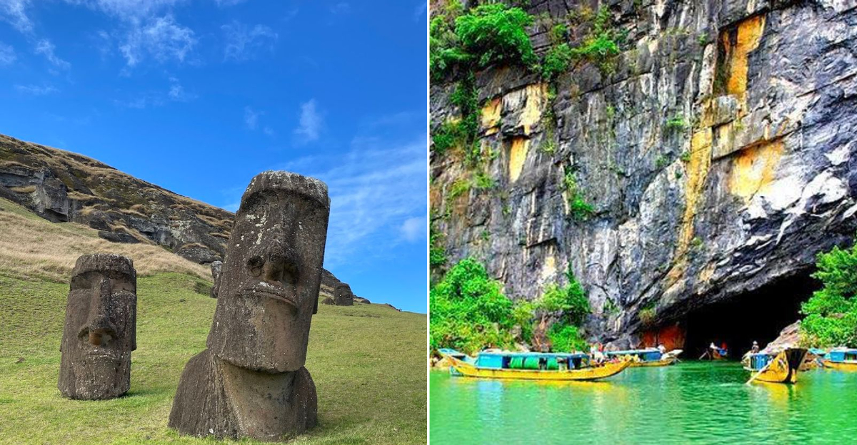
Rapa Nui National Park, Chile

Most national parks protect landscapes or ecosystems. Rapa Nui National Park protects a civilization’s memory carved into stone.
Located on Easter Island in the remote South Pacific, the park covers much of the island and safeguards the moai statues and ceremonial platforms created by the Rapa Nui people over centuries.
UNESCO describes the island as evidence of a powerful and original tradition of monumental sculpture and architecture developed in almost complete isolation for more than a millennium. There are nearly 1,000 moai statues across the island, ranging from small figures to massive carved heads and torsos reaching over 30 feet tall.
Easter Island is one of the most remote inhabited islands on Earth, located roughly 2,300 miles west of continental Chile. Flights connect from Santiago, Chile, and Tahiti.
Entry to the national park requires a fee, and some sensitive archaeological areas have restricted access to limit erosion from visitor foot traffic. The island’s combination of mystery, history, and isolation makes it genuinely unlike any other park destination.
Galapagos National Park, Ecuador

The Galapagos Islands are famous for a very specific reason: the wildlife does not run away from you. Marine iguanas bask on volcanic rocks without flinching, sea lions stretch out on park benches, and giant tortoises move through highland forests completely unbothered by nearby visitors.
That fearlessness is the result of centuries of isolation with no natural land predators.
Conservation sources describe the islands as home to endemic species found nowhere else, including Galapagos penguins, flightless cormorants, Darwin’s finches, and waved albatrosses. The volcanic landscape itself is dramatic, with lava fields, craters, and coastlines that vary significantly between islands.
Visiting the Galapagos requires permits, and most travelers book guided tours because access to many areas within the national park is restricted to licensed naturalist-led groups. The Galapagos National Park Directorate actively manages visitor numbers and conservation programs to protect the ecosystem.
The islands are accessible by flight from Quito or Guayaquil in mainland Ecuador, with most tours departing from Santa Cruz or San Cristobal island.
Phong Nha-Ke Bang National Park, Vietnam

Underground rivers, chambers large enough to fit skyscrapers, and jungle growing inside a cave opening are not things most people expect to find in one place. Phong Nha-Ke Bang National Park in central Vietnam holds some of the most dramatic cave systems on Earth, hidden beneath a karst mountain landscape covered in dense tropical forest.
UNESCO describes the park as home to highly specialized aboveground and belowground species, and the park is closely associated with Son Doong Cave, widely considered the largest natural cave passage on Earth by volume. Son Doong access is strictly controlled through a limited number of guided expedition permits each year, making it one of the more exclusive natural experiences available to travelers.
Other caves in the park, including Paradise Cave and Phong Nha Cave, are accessible through more standard guided boat and walking tours. The park is a UNESCO World Heritage Site and is located near the town of Phong Nha in Quang Binh Province.
The surrounding karst landscape is striking even without entering a single cave.
Bromo Tengger Semeru National Park, Indonesia

There are not many places where you can watch smoke rise from an active volcanic crater while standing on the rim of a massive ancient caldera, but Bromo Tengger Semeru National Park in East Java makes that experience completely accessible. Mount Bromo is an active stratovolcano sitting inside the Tengger Caldera, surrounded by a flat black sand plain known as the Sea of Sand.
The park’s official registration site shows visitor access and online booking for the Bromo sector, and the site also posts safety restrictions around the crater that change based on volcanic activity levels. Sunrise viewing from the Penanjakan viewpoint above the caldera is one of the most popular activities, with visitors gathering in the pre-dawn hours to watch the sky turn orange above the smoking peak.
Mount Semeru, Java’s highest volcano at over 12,000 feet, also sits within the park and is a destination for experienced trekkers. The combination of an active volcano, a dramatic caldera landscape, and high-altitude trekking makes this park genuinely one of a kind in Southeast Asia.
Canaima National Park, Venezuela

Canaima National Park does not look like a place that belongs on the same planet as a shopping mall or a city skyline. The park is dominated by tepuis, ancient flat-topped table mountains that rise abruptly from the jungle floor like isolated stone islands, some with sheer vertical walls dropping thousands of feet to the forest below.
UNESCO notes that the park covers approximately 3 million hectares in southeastern Venezuela and that roughly 65 percent of its surface is covered by tepui formations. The park is also home to the world’s highest waterfall, Angel Falls, which drops nearly 3,200 feet from the top of Auyantepui into the jungle below.
Accessing the park typically requires flying into Canaima village, where local Pemon Indigenous guides lead boat and trekking excursions. The tepuis are home to plant and animal species found nowhere else, because the isolation of each plateau has allowed evolution to take its own course over millions of years.
The landscape feels ancient in a way that is hard to describe until you are inside it.


