Off the northeastern tip of Chappaquiddick Island, tucked within the waters of Martha’s Vineyard, there is a stretch of land that has been quietly doing its job for centuries. Cape Poge Wildlife Refuge is a protected barrier beach ecosystem covering more than 500 acres, and it draws everyone from birders and beachgoers to off-road adventurers.
What makes this place truly stand out, though, is what waits at the end of the journey: a lighthouse that has been guiding mariners since 1801. The refuge is not just a pretty detour.
It is a place with deep history, remarkable wildlife, and a rare kind of stillness that is harder and harder to find on the East Coast.
A History That Stretches Back to 1801

The lighthouse at Cape Poge has one of the longest operational histories on the East Coast. The original structure was first established in 1801, making it one of the earliest lighthouses built in Massachusetts after the country gained independence.
The current tower is not the original, as the structure has been rebuilt and relocated multiple times due to erosion eating away at the shoreline beneath it. The lighthouse has been moved at least four times to keep it from falling into the ocean, a remarkable engineering feat each time it happened.
Throughout all those moves and rebuilds, the lighthouse has never stopped serving its core purpose: warning ships away from the dangerous shoals around Cape Poge. That consistency over more than two centuries is what gives this small, modest tower such an outsized historical weight.
Few lighthouses in New England carry a story quite this layered or this long.
The Trustees of Reservations and Their Role Here
The Trustees of Reservations, often simply called The Trustees, is the oldest land conservation organization in the world, founded in Massachusetts in 1891. Cape Poge Wildlife Refuge is one of their most celebrated properties, and they manage it with a clear priority on protecting the natural ecosystem while still allowing public access.
The organization runs guided tours to the lighthouse, which are currently the only way to access the interior of the lighthouse. These tours are led by knowledgeable guides who cover both the natural history of the refuge and the human history of the lighthouse, making the trip educational as well as scenic.
Beyond the lighthouse tours, The Trustees also oversee the trail system, beach access, and wildlife monitoring on the property. Their stewardship is a big part of why the refuge has remained in such strong ecological health despite the pressures of tourism and coastal erosion that affect so much of Martha’s Vineyard.
Over 500 Acres of Protected Barrier Beach

The sheer scale of Cape Poge Wildlife Refuge is easy to underestimate from a map. The property covers more than 500 acres of barrier beach, salt marsh, tidal flats, and upland habitat, creating a mosaic of ecosystems that support an extraordinary range of plant and animal life.
Barrier beaches like this one play a critical role in protecting inland areas from storm surge and wave action. They are also among the most dynamic landforms on the planet, constantly reshaped by wind, tide, and seasonal storms, which is part of what makes Cape Poge such a compelling place to explore.
The refuge stretches along the northeastern edge of Chappaquiddick Island, with Nantucket Sound on one side and Poucha Pond on the other. That geography creates a natural corridor for migrating birds and a sheltered habitat for marine species.
The land itself is always in motion, and that restlessness is part of its character.
The Red Cedar Grove That Sets This Place Apart

One of the most distinctive features of Cape Poge Wildlife Refuge is its grove of red cedar trees. Eastern red cedars are hardy, salt-tolerant trees that thrive in coastal environments where most other tree species struggle to survive, and they give this part of the refuge a character unlike anywhere else on the island.
Walking through the cedar grove feels like stepping into a different world compared to the open dunes and beach sections of the property. The trees are not tall by forest standards, but they are dense and twisted in ways that reflect decades of exposure to coastal winds and salt air.
Red cedars also provide important habitat for wildlife, including nesting birds and small mammals. The grove acts as a windbreak and a refuge within the refuge, offering shelter to creatures that need a break from the exposed outer beach.
It is one of those small ecological details that makes the whole property feel more complete.
14 Miles of Sand Trails Worth Every Step

Fourteen miles of sand trails wind through Cape Poge Wildlife Refuge, and no two sections feel the same. Some stretches run tight along the ocean side, with waves close enough to hear from the trail.
Others cut through salt marsh and upland scrub, offering a completely different view of the ecosystem.
The trails are not paved or groomed, which means the experience changes depending on the season, the tide, and recent weather. That unpredictability is exactly what makes the trail system appealing to people who want something more raw and less manicured than a typical nature park.
Hikers on foot can access parts of the trail network, but the full 14-mile system is best explored by vehicle or guided tour. The Trustees offer overland tours using their own four-wheel drive vehicles, which gives people without off-road capability a chance to see the entire refuge from end to end without missing a single stretch of coastline.
Wildlife That Actually Comes to You

Cape Poge is not the kind of place where wildlife hides. Deer wander through the cedar groves and dune edges with a calm that suggests they have never had much reason to fear people.
Skunks move through the underbrush at dusk, and the variety of bird species found here is enough to keep any birder busy for a full day.
The coastal waters around the refuge attract harbor seals, particularly in cooler months. They haul out on sandbars and rocky outcroppings near the lighthouse, and they have a habit of watching people just as carefully as people watch them.
That mutual curiosity makes for some genuinely memorable encounters.
Shorebirds use the tidal flats and marsh edges as feeding grounds during migration, and the refuge is recognized as an important stop along the Atlantic Flyway. Ospreys, herons, terns, and piping plovers have all been documented here, and the piping plover in particular receives special protection during nesting season.
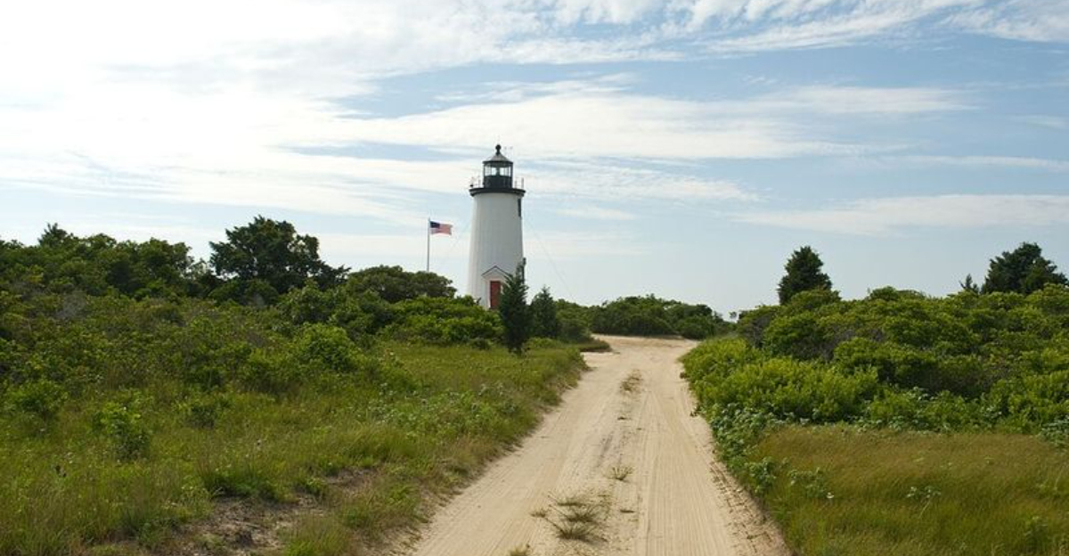
The Cape Poge Lighthouse Up Close

The Cape Poge Lighthouse is a modest structure by lighthouse standards, but its simplicity is part of its appeal. The white wooden tower stands at about 40 feet tall and sits right on the edge of the beach, with nothing but open water stretching out beyond it toward Nantucket Sound.
The lighthouse is still an active aid to navigation, meaning it continues to function as it was originally intended back in 1801. That active status gives it a different quality than a lighthouse that has been retired and turned purely into a museum piece.
Access to the interior is only available through a guided tour run by The Trustees, and those tours book up quickly during peak season. Getting to climb inside a working lighthouse with more than two centuries of history behind it is not something that happens at every coastal destination, and that exclusivity adds to the experience in a way that is hard to replicate.
How Erosion Has Shaped the Lighthouse Story

Few lighthouses in the United States have had to move as many times as Cape Poge. Coastal erosion has repeatedly threatened to swallow the structure, and the response each time has been to physically relocate the tower further from the encroaching water.
The lighthouse has been moved at least four times in its history.
The most recent relocation happened in 1987, when the tower was rolled back from the edge of an eroding bluff. That kind of engineering effort is not cheap or simple, and it reflects how seriously the preservation community has taken this particular lighthouse over the years.
Erosion is not just a historical concern here. The shoreline at Cape Poge continues to shift, and the long-term future of the lighthouse depends on ongoing monitoring and management.
That ongoing tension between preservation and natural coastal processes is one of the more thought-provoking aspects of visiting a place where the land itself is always changing shape.
Chappaquiddick Island: The Gateway to Cape Poge

Chappaquiddick Island sits just off the eastern shore of Martha’s Vineyard, separated from Edgartown by a narrow channel that a small on-demand ferry crosses in under five minutes. Despite its proximity to the main island, Chappaquiddick has a distinctly remote character that begins the moment the ferry pulls away from the dock.
The island has a small year-round population and very little commercial development, which means the roads are quiet and the landscape is largely undisturbed. Cape Poge Wildlife Refuge occupies a significant portion of the island’s northeastern end, making it the dominant natural feature of the area.
Getting to Chappaquiddick with a four-wheel drive vehicle opens up access to the refuge in a way that foot travel alone cannot match. The ferry accommodates vehicles, though spaces are limited during peak summer months and early arrival is advisable.
The island’s low-key atmosphere sets the tone for everything that follows once visitors head toward the refuge.
Best Time to Visit and What to Expect by Season

Cape Poge Wildlife Refuge is open year-round, but the experience changes dramatically depending on the season. Summer brings the largest crowds, particularly in July and August when Martha’s Vineyard is at its busiest.
Even during peak season, though, the refuge feels far less crowded than the main island towns.
Spring and fall are widely considered the best times for wildlife observation. Migratory birds move through in large numbers during both seasons, and the cooler temperatures make long walks on the beach trails far more comfortable.
Harbor seals are more commonly seen in fall and winter when they come closer to shore.
Winter visits are quiet and stark in a way that appeals to a specific kind of traveler. The refuge does not close for the season, and the beach in winter has a raw, unfiltered quality that summer can never quite replicate.
Tide charts remain important year-round, so checking conditions before any visit is always the right move.
Why Cape Poge Stays With You Long After You Leave

There are plenty of beautiful beaches and wildlife areas on Martha’s Vineyard, but Cape Poge Wildlife Refuge occupies a different category. The combination of a working lighthouse with 1801 origins, 14 miles of sand trails, a protected barrier beach ecosystem, and genuine wildlife encounters creates something that is harder to find than it sounds.
The refuge does not offer amenities. There are no concession stands, no paved parking lots, no manicured paths.
What it offers instead is access to a coastal landscape that has been carefully preserved precisely because it is worth preserving, and that restraint is what makes the experience feel real rather than packaged.
People who make the trip across the Chappaquiddick ferry and navigate the sand roads to the lighthouse end tend to leave with a stronger appreciation for what barrier beach ecosystems actually are and how much effort goes into keeping them intact. That kind of understanding is what the best wildlife refuges are ultimately built to create.
Where the Refuge Begins: Address and Access

Getting to Cape Poge Wildlife Refuge is half the adventure. The refuge is officially addressed at 40 Road To The Gut, Edgartown, MA 02539, and it sits on Chappaquiddick Island, which itself is accessible from Edgartown via a short ferry crossing.
Once on Chappaquiddick, reaching the refuge requires a vehicle with four-wheel drive, since the roads into the property are unpaved sand tracks that shift with the tides and seasons. The Trustees of Reservations manages the land, and they ask that visitors check current conditions before heading out.
The ride through the refuge is considered some of the best off-road driving on Martha’s Vineyard, with the route weaving through dunes, salt marshes, and cedar groves before opening up to open beach. Checking the tide chart before arrival is strongly recommended, especially on the bay side, where water levels can dramatically change what roads are passable.


