Volcanoes are some of the most powerful forces on Earth, capable of reshaping entire landscapes in hours. A major 2025 scientific study revealed that over 1,100 cities worldwide face real volcanic hazards, with nearly half of all people living within 62 miles of a volcano residing in urban areas.
From Southeast Asia to Central America, millions of city dwellers wake up every day in the shadow of an active volcano. These are the ten urban areas where the stakes are highest.
Bandung, Indonesia

No city on Earth sits closer to more volcanoes than Bandung. Ranked as the world’s most volcano-exposed urban area, this Indonesian metropolis has over 8 million people living within 30 kilometers of up to 12 active volcanic systems.
That is a staggering number by any measure.
Tangkuban Parahu is the most well-known of the surrounding volcanoes and has erupted multiple times in recent decades. Tourists actually visit the crater rim regularly, which says something about how normalized volcanic activity has become for locals.
The volcano last had a notable eruption in 2019, sending ash across nearby communities.
Despite the danger, Bandung thrives as a major cultural and educational hub. The city has universities, fashion markets, and a booming food scene.
Emergency preparedness programs exist, but the sheer number of surrounding volcanoes makes planning for every scenario genuinely complex. Scientists continue to closely monitor the region as the urban population keeps growing year after year.
Naples, Italy

Mount Vesuvius buried Pompeii in 79 AD, and it has not gone extinct since. Naples sits wedged between Vesuvius, the sprawling Campi Flegrei caldera, and the volcanic island of Ischia, making it arguably the most volcanically complicated city on the planet.
About 3 million people call this metro area home.
Campi Flegrei is especially worrying to scientists. Unlike a single cone volcano, it is a massive supervolcano system where the ground itself rises and falls with underground magma movement.
In recent years, ground uplift in the area has accelerated, prompting Italian authorities to raise alert levels and update evacuation plans.
Neapolitans have lived beside these threats for thousands of years, and the city retains a fierce, proud energy despite the danger. The local culture, food, and architecture are world-class.
But emergency planners know that evacuating millions of people from a narrow coastal city surrounded by volcanic systems is one of the hardest logistical problems in disaster management. Naples is breathtaking and nerve-wracking all at once.
Jakarta, Indonesia

Jakarta usually makes headlines for sinking into the sea, but volcanic exposure is another serious layer of risk for this megacity. Roughly 38 million people in the greater Jakarta metro area live within 100 kilometers of active volcanic systems on the island of Java.
Java is home to more active volcanoes than almost any other landmass on Earth.
The volcanoes surrounding Jakarta include some of Indonesia’s most historically destructive. Krakatau, whose 1883 eruption caused global climate effects and a massive tsunami, sits within the broader hazard zone.
While Jakarta itself is not directly next to a single looming cone, the regional volcanic risk is enormous and far-reaching.
Indonesia has invested in volcano monitoring infrastructure, but managing risk for tens of millions of urban residents spread across a massive region is a serious challenge. Ashfall from distant eruptions can disrupt flights, water supplies, and agriculture.
For Jakarta residents, volcanic hazard is one of several overlapping environmental threats that city planners must account for in every major infrastructure decision going forward.
San Salvador, El Salvador

El Salvador is sometimes called the Land of Volcanoes, and San Salvador wears that title more literally than most capitals. The city is encircled by 23 Holocene volcanoes, which are volcanoes that have been active within the last 11,700 years.
That density of volcanic activity around a single capital city is almost unmatched anywhere in the world.
The San Salvador volcano, also known as Quetzaltepec, sits right on the city’s edge. It last erupted in 1917, but scientists classify it as potentially active.
Other nearby threats include Santa Ana and Izalco, nicknamed the Lighthouse of the Pacific because it erupted so frequently that sailors once used its glow for navigation.
Earthquakes and volcanic eruptions often go hand in hand in El Salvador, compounding the city’s overall risk profile. The government has developed monitoring systems and early warning tools, but rapid urban growth has pushed more residents into hazard zones over the decades.
San Salvador is a city of resilience, having rebuilt after multiple disasters, yet the geological forces surrounding it remain very much alive and unpredictable.
Manila, Philippines

Taal Volcano is one of the most unusual volcanoes on Earth. It sits inside a lake, on an island, inside a larger lake, surrounded by a densely populated landscape.
And Metro Manila, home to around 24 million people, sits close enough to feel its fury when it erupts. Taal erupted violently in January 2020, forcing hundreds of thousands to evacuate and blanketing Manila in ash.
The eruption grounded flights, shut down schools, and coated streets in gray powder within hours. It was a vivid reminder that volcanic disasters are not just events that happen to remote villages.
They can paralyze one of Southeast Asia’s largest and most economically vital cities with very little warning time.
Beyond Taal, the Philippines archipelago hosts dozens of other active volcanoes, several of which fall within the broader hazard zone affecting Manila. The Philippine Institute of Volcanology and Seismology monitors these systems around the clock.
Urban planners in the region face the ongoing challenge of balancing rapid population growth with smart hazard zoning in one of the world’s most geologically active regions. Manila keeps growing, volcanoes or not.
Kagoshima, Japan

Ash for breakfast is practically a local tradition in Kagoshima. Residents here keep umbrellas handy not just for rain but for the near-constant ashfall drifting across the bay from Sakurajima, one of Japan’s most persistently active volcanoes.
The city of roughly 600,000 people has built its entire culture around living beside a volcano that erupts hundreds of times per year.
Sakurajima was once an island but its 1914 eruption was so massive that lava flows connected it to the mainland. Today you can drive right up to viewing platforms near the crater.
The city operates ash collection programs, distributes free ash disposal bags to residents, and runs regular evacuation drills to keep everyone sharp and prepared.
Japan’s volcanic monitoring network is among the best in the world, and Kagoshima benefits from that investment. Scientists track seismic activity, gas emissions, and ground deformation in real time.
Schools teach children from a young age how to respond to eruption alerts. What might seem terrifying to an outsider is, for Kagoshima residents, simply part of the rhythm of daily life beside one of nature’s most theatrical performers.
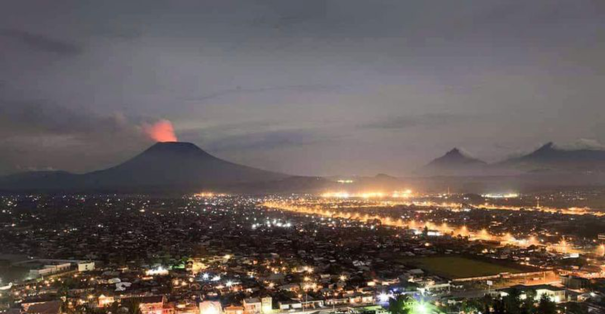
Goma, Democratic Republic of the Congo

Mount Nyiragongo holds lava that moves faster than almost any other volcano on Earth. The reason is its unusually low silica content, which makes the lava thin and extremely fluid.
Goma, a city of around 2 million people on the shore of Lake Kivu, sits directly in the path of Nyiragongo’s most likely lava flow routes. That is not a comfortable geological neighborhood.
In May 2021, Nyiragongo erupted with little warning, sending fast-moving lava flows toward Goma. Thousands of homes were destroyed and tens of thousands of people fled.
The eruption also triggered fears about volcanic gases dissolving into Lake Kivu, which contains enormous amounts of dissolved carbon dioxide and methane deep in its waters.
Goma’s situation is made harder by political instability in the region, which limits funding for monitoring equipment and emergency infrastructure. Despite these obstacles, local scientists and international partners work to maintain alert systems.
The city continues to grow rapidly, which means more people are moving into areas that previous lava flows have already shown are not safe. Nyiragongo is not finished, and everyone in Goma knows it.
Arequipa, Peru

El Misti watches over Arequipa like a sentinel, its snow-capped cone rising to over 5,800 meters directly above the city. It is one of the most visually dramatic urban-volcano relationships in the world.
More than one million people live in Arequipa’s metropolitan area, and the volcano they live beneath is considered Peru’s most dangerous because of exactly that proximity.
El Misti last erupted around 1985, but geological evidence shows it has produced explosive eruptions capable of sending pyroclastic flows toward the city in the past. Pyroclastic flows are fast-moving currents of hot gas and volcanic matter that are nearly impossible to outrun.
Scientists studying the volcano’s history have found ancient deposits within what is now the city itself.
Peruvian authorities and researchers from international institutions actively monitor El Misti using seismic sensors and satellite data. Arequipa is also known as the White City because of its stunning colonial architecture built from white volcanic stone called sillar, which was quarried from old volcanic deposits.
The city quite literally grew from the volcano above it. That relationship is beautiful, historically rich, and genuinely dangerous all at the same time.
Tokyo, Japan

Mount Fuji has been quiet since 1707, but quiet does not mean retired. Japan’s most iconic mountain is an active stratovolcano sitting roughly 100 kilometers from the center of one of the world’s largest cities.
Greater Tokyo has around 30 million residents, and scientists take Fuji’s potential reawakening very seriously. A major eruption today would be catastrophic on a scale hard to imagine.
A government report estimated that a Fuji eruption could dump enough ash on Tokyo to shut down transportation networks, contaminate water supplies, and cost the economy hundreds of billions of dollars. Ashfall even a few centimeters deep can collapse roofs, short-circuit electronics, and make roads impassable.
The 1707 eruption deposited ash across the Kanto region for weeks.
Japan’s Meteorological Agency monitors Fuji continuously, and Tokyo has begun updating its volcanic disaster response plans in recent years. Beyond Fuji, other volcanic systems also fall within the broader Tokyo hazard zone, including the Izu-Ogasawara volcanic arc.
For most Tokyoites, Fuji is a symbol of beauty and national pride. Behind the scenes, however, emergency planners treat it as one of the most serious long-term risks facing the entire country.
Quito, Ecuador

Quito has a volcanic resume that would make most city planners lose sleep. Ecuador’s capital sits at over 2,800 meters above sea level in the Andes, surrounded by Pichincha, Cotopaxi, and Antisana, all of which are active.
In 1999, Pichincha erupted and buried Quito under a thick layer of ash, grounding flights and coating the city in gray for days. Residents still remember the eerie silence that followed.
Cotopaxi is the bigger long-term concern. At nearly 5,900 meters, it is one of the world’s highest active volcanoes and has a history of producing massive lahars, which are volcanic mudflows that can travel at terrifying speeds through river valleys leading directly toward populated areas.
A major Cotopaxi eruption could send lahars toward Quito’s suburbs within hours of an event starting.
Ecuador has invested significantly in volcano monitoring and public education. Schools regularly conduct eruption drills, and evacuation maps are posted in public spaces across the city.
Quito also serves as a base for volcanologists studying the region’s complex geology. Living in a city ringed by volcanoes demands constant awareness, and Quito’s residents have turned that awareness into a genuine culture of preparedness that other high-risk cities could learn from.


