There is a trail in coastal Oregon that most people drive right past without knowing it exists, and that is honestly their loss. Tucked along a winding road near the small town of Mapleton, this short hike packs in more waterfalls, mossy canyon walls, and crystal-clear swimming holes than trails twice its length.
The total distance is just 2.2 miles out and back, yet somehow it feels like you have wandered into a completely different world. By the time you finish reading this, you will understand exactly why hikers keep coming back to Sweet Creek Falls Trailhead again and again.
Where Exactly You Are Going

The Sweet Creek Falls Trailhead sits at the end of Sweet Creek Road in Mapleton, Oregon 97453, roughly eleven miles from Mapleton and about fifteen miles from Florence via Highway 126. The phone number for the managing agency, the Siuslaw National Forest, is (541) 750-7000, and you can find more details at the official USDA Forest Service page at fs.usda.gov.
The drive to the trailhead from Highway 126 is genuinely beautiful, winding through tall trees with the creek flashing in and out of view. That said, the road does narrow to a single lane past the first parking area, so take your time and watch for oncoming traffic.
There are actually two main parking areas here. The lower Homestead Trailhead has a vault toilet and about ten parking spots, while the upper lot offers roughly fifteen to twenty spaces but no restroom.
Arriving before 11 a.m. on weekends is a smart move if you want a spot without stress.
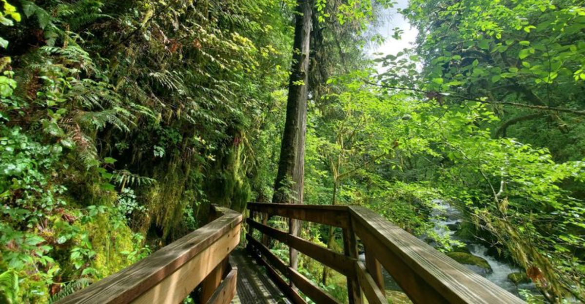
The Trail Itself: What to Expect Underfoot

Right from the first steps, the trail makes its personality known: exposed tree roots, mossy rocks, and patches of mud are all part of the deal. The path follows Sweet Creek through a narrow canyon, and the terrain is uneven enough that you need to watch your footing the whole way.
The hike is classified as easy in terms of elevation gain, and most reasonably fit adults and older kids handle it without getting winded. However, the rocky, root-covered surface means it is not suitable for strollers, and anyone with balance concerns should bring trekking poles.
Poison oak grows along sections of the trail, so wearing long pants and staying on the marked path is a genuinely good idea. The total round trip from the lower trailhead runs about 1.3 miles, while starting from the upper lot cuts the distance to under a mile.
Either way, you are looking at a 45-to-60-minute experience that punches well above its weight in scenery.
A Canyon Full of Waterfalls

One waterfall would be enough to justify the drive. Sweet Creek delivers eleven of them along its corridor, ranging from wide curtain drops to narrow chutes that shoot between basalt walls.
Water weeps from moss-covered rock faces even between the main falls, so there is almost no section of trail where you are not hearing or seeing moving water.
The most dramatic waterfall sits near the upper end of the trail, where the creek drops in a fast, powerful rush over a broad ledge. This is the one most photographers aim for, and it earns the attention.
The lower falls are subtler but have a quiet, almost meditative quality that is easy to appreciate.
Late summer visits, like those in August, show the falls at their more relaxed pace, while winter and spring bring the creek roaring to life with noticeably higher water volume. Each season gives a genuinely different experience, which explains why so many people list this as a repeat destination rather than a one-time stop.
Swimming Holes That Actually Deliver

Not every hike doubles as a swimming destination, but this one absolutely does. The creek carves out a series of natural pools along its route, and the water is clear enough to see the bottom even in the deeper sections.
One visitor who brought goggles reported visibility all the way down in pools that run several feet deep.
The water is cold, there is no way around that, but it warms up quickly once you commit. On hot summer days when temperatures push into the eighties, the cool creek becomes the main attraction rather than a side note.
Families regularly pack lunches and spend three to four hours here rather than the standard one.
Water shoes are a smart addition to your pack, especially if you plan to wade between pools or walk sections of the creek bed itself, which is something many visitors choose to do. A swimsuit tucked into your daypack weighs almost nothing and could turn a nice hike into a genuinely memorable afternoon by the water.
The Forest Surrounding the Trail

The tree canopy above the trail is dominated by tall Douglas fir, red alder, and big-leaf maple, and together they create a shaded corridor that stays noticeably cooler than the surrounding landscape. Even on days when the temperature climbs into the eighties outside, the forest keeps things comfortable along the creek.
Thick mats of moss cover nearly every surface, from the boulders in the creek bed to the bark of fallen logs. The color of the vegetation here is almost absurdly green, the kind of saturated forest tone that makes you stop and stare for a moment before continuing down the path.
Banana slugs make regular appearances on the trail, especially after rain, and they are genuinely charming in a slow, slimy kind of way. Park rangers have been known to set up interpretive stations along the path, complete with information about local flora, fauna, and even beaver activity in the watershed.
The forest here is not just a backdrop; it is an active, layered ecosystem that rewards anyone who slows down enough to notice it.
Trail Conditions and Seasonal Considerations

Sweet Creek Road is paved all the way to the trailhead, which is a genuine convenience, but winter driving demands real caution. The road twists through multiple sharp curves, and frost or ice in the early morning hours can make those turns genuinely tricky.
Going slowly and giving yourself extra time on cold mornings is not optional advice here.
The trail itself gets muddy in wet weather, particularly in January and February when the creek runs highest. Some sections become narrow and slippery enough that passing other hikers requires coordination and patience.
The upside is that the waterfall volume during this period is stunning, and the forest feels especially alive.
Trail closures have affected the lower Homestead section at various points due to bridge repairs and washouts, so checking current conditions before your visit is worth the two minutes it takes. The upper parking area and its shorter trail segment have generally remained accessible even when the lower section is closed.
Calling the Siuslaw National Forest at (541) 750-7000 before a winter or early spring visit is a reliable way to avoid a wasted drive.
Parking, Facilities, and Practical Logistics

Parking at Sweet Creek Falls is free, which feels like a small gift in an era when trailhead fees have become standard across the Pacific Northwest. The lower Homestead lot holds about ten cars, and the upper lot fits somewhere between fifteen and twenty depending on how people park.
On summer weekends, both fill up fast.
The vault toilet at the lower trailhead is functional but carries the kind of reputation that precedes it. Bringing hand sanitizer is a genuinely good call, and arriving early enough to snag a spot before the crowds arrive solves most of the logistical headaches in one move.
The upper lot has no restroom at all, so plan accordingly. There are no concessions, no visitor center, and no cell service to speak of once you are deep in the canyon, so download offline maps and bring everything you need before leaving the highway.
The trailhead is open 24 hours every day of the week, which technically means a sunrise visit is possible, though the narrow road in the dark is an adventure best left to those who know it well.
Who This Hike Works Best For

Sweet Creek Falls draws a genuinely wide range of visitors, from solo hikers with cameras to families with older kids and groups of friends looking for a swimming spot. The low elevation gain makes it approachable for people who do not consider themselves serious hikers but still want a real outdoor experience.
Younger children can handle the hike with adult supervision, but the uneven surface, exposed roots, and lack of guardrails along the creek mean it requires active attention rather than a relaxed stroll. Strollers are a firm no on this trail.
Dogs are welcome and appear frequently, though the narrow sections mean keeping them leashed and under control is both courteous and necessary.
Older adults who use walking sticks will find them genuinely useful here, particularly on the rockier sections near the falls. The trail rewards patience and a willingness to move at a comfortable pace rather than rushing to the end.
Anyone expecting a flat, paved path will be surprised, but anyone who comes prepared for a lively, uneven trail through a spectacular canyon will leave thoroughly satisfied.
Photography Opportunities Along the Creek

Few short hikes in Oregon offer this many distinct compositions in such a small distance. Every bend in the creek reveals a new angle: water rushing between narrow basalt walls, wide curtain falls dropping into quiet pools, moss-draped logs spanning the creek, and ferns catching the light filtering through the canopy above.
Long exposure shots of the falls work especially well here because the canyon walls block harsh direct sunlight for most of the day, giving photographers soft, diffused light that is flattering to moving water. An overcast day is not a disappointment at Sweet Creek; it is arguably the best possible shooting condition.
The upper falls, with their bold drop and wide frame, tend to be the headline shot, but the subtler mid-trail cascades are where the most interesting textures live. Moss patterns on wet rock, the color gradient of a deep pool, a banana slug crossing a rain-soaked log: the details here are as rewarding as the main events.
A waterproof camera bag or a dry bag for your gear is worth bringing, since trail spray near the falls is a real factor on high-flow days.
Why People Keep Coming Back

There is a particular kind of trail that earns its reputation not through spectacle alone but through a combination of accessibility, beauty, and the feeling that you have genuinely earned what you are seeing. Sweet Creek Falls sits firmly in that category.
The hike is short enough to feel manageable and varied enough to feel like an adventure.
The repeat visitor rate here is unusually high for a trail of this length. Families come back each summer to reclaim their favorite swimming spot.
Photographers return in different seasons to capture the falls at different water levels. Locals from Eugene, about 1.15 hours away, treat it as a reliable half-day escape when the week demands a reset.
The trail is part of the larger Siuslaw National Forest system, which includes four separate trailheads along the Sweet Creek corridor, so there is always more to explore for those who want to extend their day. Whether you visit once out of curiosity or build it into a yearly tradition, the combination of easy access, natural swimming, and genuinely beautiful waterfalls makes this one of the most rewarding short hikes on the Oregon coast range.


