Far beneath the waves of the South Pacific lies an entire continent that most of us never learned about in school. Zealandia, often called Earth’s “eighth continent,” has been hiding in plain sight for millions of years, with only tiny pieces like New Zealand poking above the ocean’s surface. Scientists have recently completed a groundbreaking geological map of this submerged landmass, revealing secrets about how continents form, break apart, and sometimes disappear beneath the sea. This discovery is changing how we understand our planet’s history and might even help predict future geological changes.
Complete Mapping Reveals Hidden Features
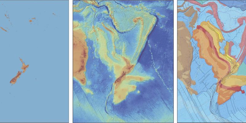
For the first time ever, scientists have mapped an entire continent from edge to edge, including all its underwater boundaries. Zealandia became the first continent to receive this honor in 2023, when researchers at GNS Science finished charting its complex geography. The team collected rock samples from the seafloor—sandstone, mudstone, and basaltic lava—to understand how this massive landmass formed and changed over time.
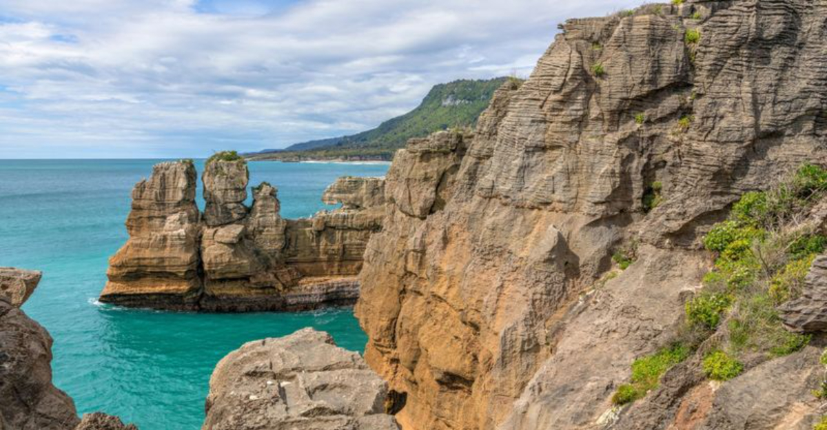
What they found was extraordinary: a 4,000-kilometer-long granite spine called the Median Batholith running through the continent’s core. They also discovered a volcanic region covering 250,000 square kilometers, roughly the size of New Zealand itself. These features help explain why Zealandia looks the way it does today and why most of it ended up underwater while other continents stayed above the waves.
Ancient Origins Twice as Old as Expected
Imagine discovering that something you thought was 500 million years old is actually over a billion years old! That’s exactly what happened when scientists studied Zealandia’s rocks more carefully. Earlier estimates suggested the continent formed relatively recently in geological terms, but new evidence proves it’s approximately twice as ancient as previously believed.
Rock samples dating back 130 million years to the Early Cretaceous period show only part of the story. Deeper analysis reveals sections that existed long before dinosaurs walked the Earth. This extended timeline makes Zealandia’s geological history far more complex than anyone imagined, connecting it to the ancient supercontinent Gondwana in fascinating ways.
Understanding these ancient origins helps scientists piece together how Earth’s surface has shifted and changed throughout history.
Crustal Thinning Explains the Great Sinking
Why did Zealandia sink while other continents stayed high and dry? Scientists finally have the answer, and it’s all about stretching. The continent’s crust underwent extreme thinning—up to 65 percent in some areas—which caused it to drop below sea level like a deflating balloon sinking in water.
This discovery overturns older theories that blamed strike-slip faulting (where land slides sideways along fault lines) for Zealandia’s breakup. Instead, tectonic forces pulled and stretched the continent until its crust became too thin to support its own weight above water. Think of it like stretching pizza dough until it becomes paper-thin and tears.
Today, Zealandia’s crust measures between 10 and 30 kilometers thick in most places, with some sections under New Zealand’s South Island exceeding 40 kilometers.
Why This Submerged Continent Matters
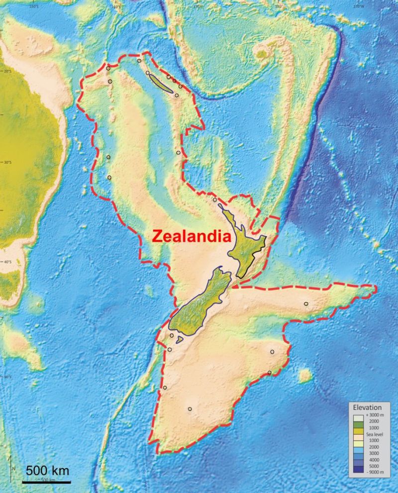
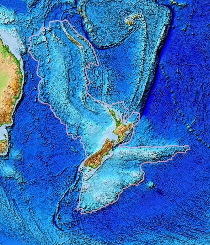
Covering roughly 4.9 to 5 million square kilometers—about two-thirds the size of Australia—Zealandia qualifies as a true continent despite being 95 percent underwater. It meets all the scientific criteria: substantial area, isolated crustal mass, varied rock types, and a distinct tectonic history separate from surrounding oceanic crust.
Beyond settling scientific debates about continent classification, Zealandia’s mapping provides practical benefits for our modern world. Understanding its structure helps researchers assess earthquake and tsunami risks for Pacific nations sitting atop it. The detailed geological knowledge also guides resource exploration efforts and improves our understanding of ocean-floor processes.
Perhaps most importantly, Zealandia offers a living laboratory for studying how continents evolve, fragment, and sometimes vanish beneath the waves—lessons that apply to understanding Earth’s entire geological past and future.


