A powerful winter storm is sweeping from coast to coast, bringing a volatile mix of wind, rain, and snow right as holiday travel peaks. You can expect shifting conditions that change by the hour, with fast moving bands that challenge even seasoned travelers. If you have flights or long drives planned, this is the update you need before you pack the car or head to the airport. Stay alert, stay flexible, and use these insights to keep your plans on track.
Coast-to-Coast Winter Storm to Bring Wind, Rain, Snow and Travel Disruptions
A sprawling storm is trekking from the Pacific Northwest to the Northeast, packing damaging wind, soaking rain, and heavy snow that will disrupt travel in more than 30 states. You will feel the impacts even if you are miles from the storm center, thanks to widespread wind fields and fast moving fronts. Expect changing conditions within hours as the system intensifies while crossing the Rockies and Plains.
Wind gusts will commonly reach 50 to 70 mph, with isolated peaks near 80 to 90 mph in parts of Montana and nearby states. Those gusts can down trees and power lines, cause scattered outages, and create hazardous crosswinds for high profile vehicles. If you are driving, secure cargo, slow down on open stretches, and plan extra time.
As the storm slides east, rain will soak the Midwest and Ohio Valley before pushing into the Northeast, while colder air behind the front flips precipitation to snow. Wet roads can turn slick where temperatures drop, and higher elevations will see accumulating snow that worsens overnight. Airport delays are likely as crosswinds and runway conditions force ground stops and cancellations.
Because the timing aligns with pre Christmas travel, ripple effects could extend far beyond the hardest hit zones. Keep close tabs on National Weather Service alerts and airline notifications for real time changes. Flexible itineraries, early departures, and backup routes can make the difference between a smooth trip and a stranded night.
Wind and Rain in the West and Plains Could Hamper Holiday Travel

As the storm barrels out of the Pacific Northwest into the Northern Rockies and Plains, expect strong winds and periods of heavy rain to complicate travel on major corridors. Gusts of 50 to 70 mph are likely, with localized blasts approaching 80 to 90 mph in exposed areas. Those speeds can shove vehicles, especially semis and high profile SUVs, and kick up dangerous debris.
Wet roads combined with powerful crosswinds reduce visibility and traction, raising the risk of hydroplaning on long stretches. If you plan to drive, slow down, increase following distance, and avoid passing large trucks during stronger gusts. Power outages are possible where trees and lines come down, so carry chargers, a flashlight, and extra layers.
Rain in the storm’s warm sector will arc from the Central Plains into the Mississippi and Ohio Valleys, soaking commutes and rural routes alike. Cold road surfaces can turn slick even without snow, and temperatures will tumble behind the cold front. Mountain passes in the Rockies may require chains, and temporary closures are possible as snow mixes in at higher elevations.
Air travel will also feel the squeeze, with crosswinds prompting runway changes and delays at regional and hub airports. You can minimize headaches by checking airline apps frequently, choosing earlier flights, and packing essentials in a carry on for quick rebooking. If you must drive long distance, map alternate routes and schedule fuel stops where services are reliable during outages.
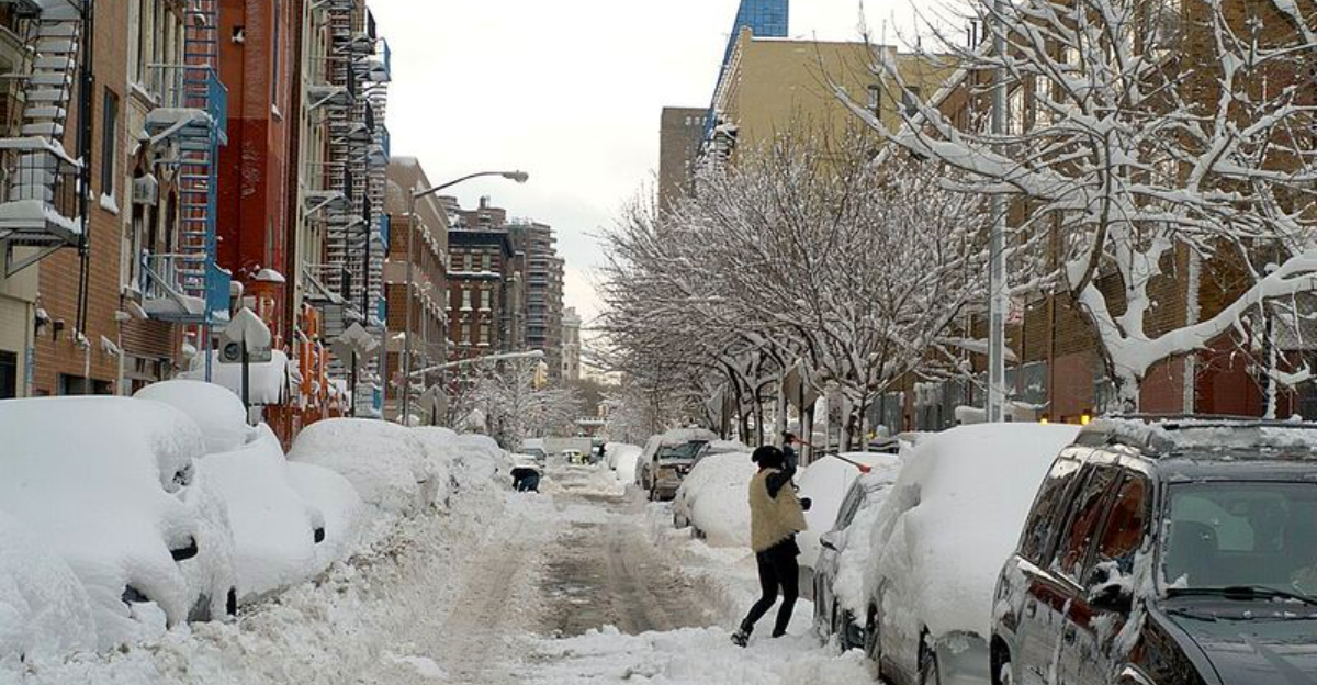
Snow and Cold Behind Storm Could Affect Midwest, Great Lakes and Northeast
Behind the initial wall of rain and wind, colder air will surge south and east, switching many areas to snow from the Midwest through the Great Lakes and into the Northeast. This classic setup delivers rain first, then a sharp changeover as the front passes. You might see temperatures fall quickly enough for flash freeze conditions on untreated surfaces.
Accumulations will vary, but several inches are possible in lake enhanced zones and higher terrain, with localized heavier bursts under persistent bands. Blowing and drifting snow can produce white knuckle stretches, especially on exposed interstates and rural roads. If you must travel, time your departure between bands and keep a winter kit with traction aids, water, and snacks.
Airports from Chicago to the New York metro can expect de icing delays, gate holds, and occasional ground stops as visibility slips. Even moderate snow creates ripple effects, so a delay in one hub can cascade across the network. Build flexibility into connections and monitor gate changes closely.
As temperatures drop, black ice becomes a stealth hazard on bridges, ramps, and shaded roads. Pedestrians face risks too, so use proper footwear and avoid refreezing puddles. Check local National Weather Service advisories for Winter Storm Warnings and Snow Squall Warnings, which signal brief but intense visibility drops that demand immediate speed reduction.
Broader Winter Weather Context and Preparedness Tips
This coast to coast event fits an active winter pattern featuring frequent storms, sharp temperature swings, and fast moving fronts. La Nina influenced jet stream tracks can funnel energy across the nation, toggling regions between rain, wind, snow, and bitter cold. That variability challenges forecasts and your plans, so preparation becomes your best advantage.
Think in layers of redundancy to outsmart disruptions. For flights, book morning departures, avoid tight connections, and keep medications and chargers in your carry on. For road trips, top off fuel early, download offline maps, and stash a winter kit with warm layers, shovel, traction mats, snacks, and a headlamp.
At home, assemble a 72 hour kit with water, shelf stable food, batteries, and a way to receive alerts if power fails. Portable power banks and a battery radio keep you connected when cell towers wobble. If you rely on medical devices, ask providers about backup options and notify your utility of critical needs.
Stay weather aware using official National Weather Service pages, local alerts, and reliable aviation or DOT feeds. Verify forecast updates the night before and morning of travel, since storm tracks and wind corridors can shift. Flexibility matters: leaving earlier, rerouting around mountain passes, or rolling to a later flight can turn a stormy week into a manageable inconvenience rather than a major ordeal.


