Imagine a crack in the earth stretching over 600 miles, sitting quietly beneath Canada’s remote northern wilderness. For millions of years, scientists believed the Tintina fault was fast asleep, posing no real danger to anyone. Now, startling new research reveals this massive fault line might still be active, capable of unleashing a devastating earthquake that could shake entire communities and rewrite our understanding of Canada’s geologic safety.
A Fault Long Thought Dormant
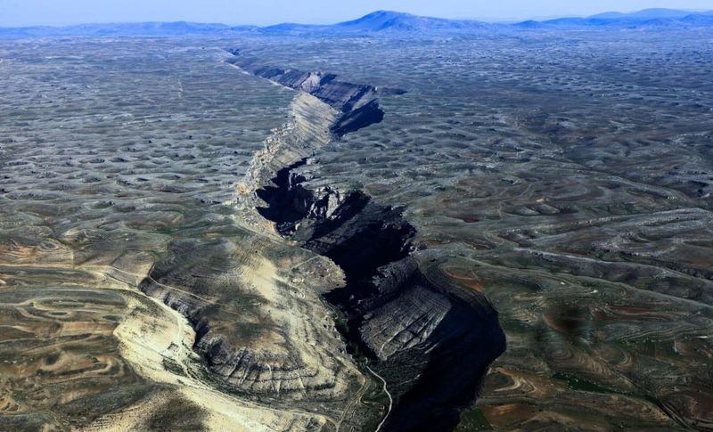
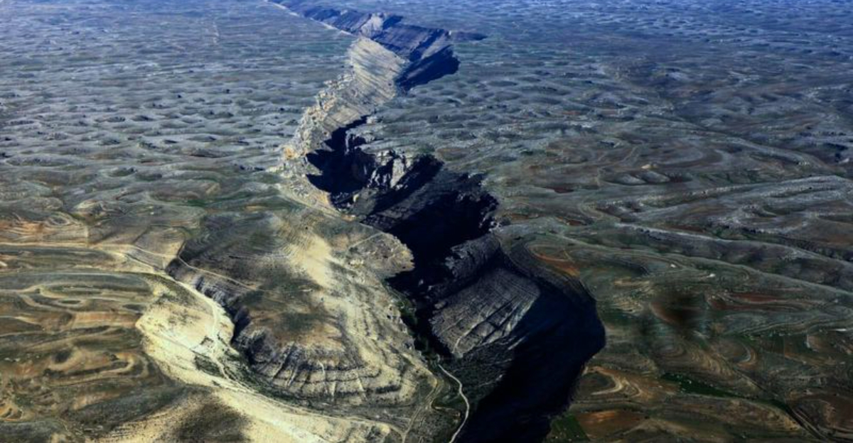
Beneath the wild and untouched landscapes of Canada’s Yukon Territory, a geological giant has been hiding in plain sight. The Tintina fault stretches more than 1,000 kilometers, cutting through Yukon and extending all the way into Alaska. For decades, geologists assumed this massive boundary between tectonic plates had gone completely quiet, with no earthquakes or tremors recorded in modern times.
Recent discoveries have flipped that assumption on its head. Advanced mapping and ground surveys now show the fault may still hold dangerous seismic energy. What was once considered a sleeping giant could actually be a ticking time bomb, challenging everything scientists thought they knew about stability in this remote region.
Signs of Recent Movement
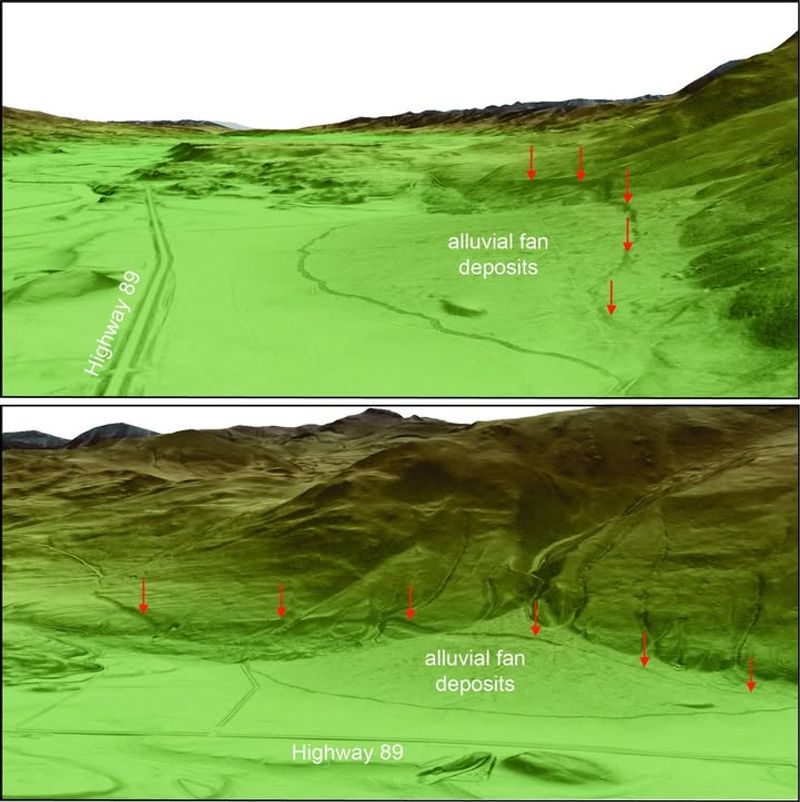
Modern technology has given scientists a powerful new lens to examine the earth beneath our feet. Teams from the University of Victoria, Geological Survey of Canada, and University of Alberta deployed cutting-edge LIDAR surveys, satellite imaging, and high-resolution mapping to scan the Tintina fault in extraordinary detail. What they found was both surprising and alarming: fresh fault scarps and small but unmistakable shifts in the ground surface.
Some of these displaced landforms are incredibly young in geological terms, dating back only to the Quaternary period—the last 2.6 million years. That means the fault has been moving far more recently than anyone expected, shattering the myth of its dormancy and raising serious questions about future seismic activity in the region.
Strain Buildup and Slip Deficit
Every year, the Tintina fault is quietly collecting stress, building up energy like a coiled spring. Researchers have measured strain rates between 0.2 to 0.8 millimeters annually—tiny movements that add up over centuries. This slow but steady accumulation creates what geologists call a slip deficit, where pressure mounts until the fault can no longer hold it back.
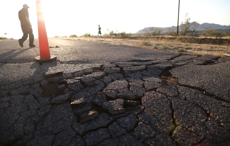
When that breaking point arrives, the release could be catastrophic. Scientists estimate that a sudden rupture could trigger an earthquake reaching magnitude 7.5 or even higher, based on calculations of stored energy along the fault. That kind of quake would be felt across vast stretches of northern Canada and could cause serious damage to anything nearby.
Potential Impact Zones
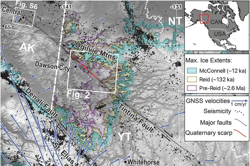
If the Tintina fault suddenly lets loose, communities like Dawson City and surrounding areas in the Yukon would be in the direct line of danger. These remote towns depend heavily on fragile infrastructure—narrow highways, aging power lines, and active mining operations—all of which could be severely damaged or destroyed by intense shaking.
Beyond the immediate destruction, secondary hazards could make things even worse. Landslides are common in the rugged terrain, and a major quake could trigger massive rockfalls and ground ruptures. Transportation routes and supply chains would be cut off, leaving isolated communities struggling to recover. Emergency response in such a remote region would face enormous challenges, making preparedness absolutely critical.
Rewriting Regional Seismic Maps
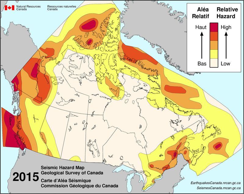
The revelation that the Tintina fault might still be active is forcing scientists to rethink seismic hazard maps across western Canada and Alaska. For years, these regions were considered relatively stable, with low earthquake risk compared to coastal zones. Now, it appears that even continental interiors can harbor hidden fault zones with serious potential for destruction.
This shift has major implications for how communities plan for the future. Building codes may need to be updated to account for stronger shaking. Emergency preparedness plans will require revision. Risk assessments that once dismissed northern territories as safe zones must now take a harder look at what lies beneath, ensuring that people and infrastructure are better protected from a threat that was hiding in plain sight.
What Scientists Will Do Next
Confirming the full extent of the Tintina fault’s threat will take years of dedicated research and careful monitoring. Geologists are planning deeper drilling projects to sample rocks and sediments directly from the fault zone. They’ll use advanced seismic imaging to map the fault’s structure far below the surface, revealing hidden details that satellites can’t detect.
Continuous monitoring will also play a key role. Scientists will track microseismic activity—tiny tremors too small to feel but important for understanding fault behavior. Ground deformation measurements will show if the earth is slowly shifting. By studying nearby landforms and combining all this data, researchers hope to build a complete picture of the fault’s activity and predict when the next big quake might strike.
A Wake-Up Call for Canada
For a country that prides itself on natural beauty and vast, untouched wilderness, the discovery of an active fault line in the Yukon serves as a sobering reminder that danger can lurk where we least expect it. Canada’s northern territories have long been seen as geologically stable, far from the earthquake-prone coasts. The Tintina fault challenges that complacency.
This wake-up call demands action. Communities need better education about earthquake preparedness. Infrastructure must be evaluated and strengthened where necessary. Most importantly, ongoing research and monitoring must remain a priority. The Tintina fault has been silent for thousands of years, but that silence may not last forever. Understanding and respecting the power beneath our feet is the first step toward staying safe.


