For centuries, mountain passes served as vital links between regions, allowing travelers, merchants, and armies to cross some of the world’s most challenging terrain. Long before modern roads and technology, these routes demanded courage, endurance, and a willingness to face unpredictable conditions.
Many became famous for the trade they enabled, while others gained reputations for their dangers and hardships. Beyond their spectacular scenery, these passes tell stories of human determination and survival in landscapes that often seemed impossible to cross.
The routes on this list reveal how a simple path through the mountains could shape history.
1. Khyber Pass, Khyber Pakhtunkhwa, Pakistan

Few corridors on earth have seen more history squeeze through them than this narrow cut in the mountains between Pakistan and Afghanistan.
For at least 3,500 years, the Khyber Pass served as a gateway between Central Asia and the Indian subcontinent. Armies led by Alexander the Great, Genghis Khan, and the Mughal emperors all used this route to push through the Hindu Kush mountains.
Traders carrying silk, spices, and precious goods also relied on it, though bandits and hostile tribal groups made every journey a calculated risk.
The pass stretches about 53 kilometers and reaches a maximum elevation of roughly 1,070 meters. It narrows in some sections to just a few meters wide, making it easy to defend and nearly impossible to avoid.
British colonial forces spent decades trying to control it, which says everything about how strategically important it was. Today, the pass remains a restricted area requiring special permits to visit.
2. Donner Pass, California, USA

The name alone carries a chill that has nothing to do with the weather. Donner Pass became permanently linked to one of the most harrowing survival stories in American history after the winter of 1846.
A group of westward-bound settlers, now known as the Donner Party, became trapped by early and unusually heavy snowfall in the Sierra Nevada. Of the 87 people in the group, only 48 survived the winter.
Before modern highways and snowplows, this crossing was a genuine gamble for anyone attempting it late in the season. The east side of the pass drops nearly 1,000 feet through a series of tight switchbacks that challenged even experienced wagon drivers.
Today, Interstate 80 cuts through the same general area, and the pass sits at about 7,056 feet above sea level. A monument near Donner Lake marks the site where the stranded party built their winter camps.
The granite walls surrounding the pass still look imposing, even on a clear summer day.
3. Great St. Bernard Pass, Valais, Switzerland and Aosta Valley, Italy

Monks, soldiers, and merchants have been crossing this high Alpine pass for nearly 2,000 years, which makes it one of the oldest continuously used mountain crossings in Europe.
The Great St. Bernard Pass sits at about 2,469 meters and links Switzerland with Italy through some of the western Alps’ most dramatic terrain. Avalanches, blizzards, and rapidly shifting weather made winter crossings extremely dangerous before modern infrastructure existed.
Around the year 1050, a monk named Bernard of Menthon established a hospice near the summit to shelter and rescue stranded travelers. That hospice is still operating today, making it one of the longest-running mountain rescue operations in history.
The famous St. Bernard dogs were bred at this location specifically to help locate travelers buried in snow. Napoleon Bonaparte famously led around 40,000 troops through this pass in 1800, though the crossing cost him a significant number of men and horses.
A road tunnel now bypasses the summit for most of the year, but the pass itself opens each summer for visitors.
4. Khunjerab Pass, Gilgit-Baltistan, Pakistan and Xinjiang, China

At over 4,693 meters above sea level, this pass is not just high, it is the highest paved international border crossing in the world.
The Khunjerab Pass connects Pakistan’s Gilgit-Baltistan region with China’s Xinjiang province along what is now called the Karakoram Highway. Before modern road construction, travelers on this route faced altitude sickness, frostbite, and the ever-present risk of rockfalls and avalanches.
Building the highway itself was no small feat. Construction between 1959 and 1979 resulted in the deaths of more than 800 Pakistani workers and around 200 Chinese workers, primarily due to landslides and harsh conditions.
The surrounding landscape is stark and almost surreal, with the Karakoram mountain range rising on all sides. Marco Polo sheep, one of the world’s largest wild sheep species, roam the high-altitude plateau near the pass.
The border crossing is only open to travelers during warmer months, typically from May to November, due to the extreme conditions that close it off every winter.
5. Zoji La Pass, Ladakh, India

Carved into the side of the Himalayas at about 3,528 meters, Zoji La is the kind of road that makes even confident drivers grip the steering wheel a little tighter.
This 9-kilometer pass connects the Kashmir Valley with the Ladakh region and serves as a critical supply route for communities that would otherwise be completely cut off during winter. For centuries before any road existed, traders and locals crossed on foot, navigating loose rock, ice, and sheer drops with no safety barriers of any kind.
The modern road is only marginally more forgiving. Sharp bends, unpaved sections, and patches of ice are common even during the summer months when the pass is technically open.
Heavy snowfall typically closes Zoji La from late November through April, isolating Ladakh from the rest of India. Military convoys use the pass to supply Indian Army posts along the border with Pakistan, which adds another layer of strategic importance to this already vital route.
A tunnel project is currently underway to eventually provide year-round access.
6. Stelvio Pass, South Tyrol, Italy

Forty-eight numbered hairpin turns on the eastern side alone, and that is just warming up. Stelvio Pass in northern Italy is widely considered one of the most dramatic mountain roads ever built.
Constructed between 1820 and 1825 under Austrian rule, the pass reaches 2,757 meters, making it the highest paved mountain road in the Eastern Alps. Its original purpose was military, connecting the Austrian Empire’s territories across the Alps with greater efficiency than the routes available at the time.
For traders and travelers in earlier centuries, the steep and unpredictable terrain made every crossing a serious undertaking. Loaded carts had almost no margin for error on the narrow, winding path, and a single misjudged turn could mean disaster.
Today, the pass draws cyclists and drivers from around the world who come specifically to test themselves against its legendary switchbacks. The road is closed from November to late May due to heavy snowfall.
Standing at the summit on a clear day, you can see into three countries: Italy, Switzerland, and Austria.
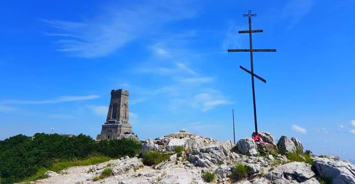
7. Shipka Pass, Stara Planina Mountains, Bulgaria

Bulgaria’s Balkan Mountains hold many stories, but Shipka Pass carries more history per kilometer than almost any other route in southeastern Europe.
The pass sits at about 1,185 meters and cuts through the Stara Planina range, connecting northern and southern Bulgaria. For centuries, it was a key route for trade and migration, but it became truly famous during the Russo-Turkish War of 1877 to 1878.
Russian and Bulgarian forces held the pass against repeated Ottoman attacks during brutal winter conditions. The battle was fierce enough that the pass changed hands multiple times before defenders ultimately held their position.
Thousands of soldiers on both sides lost their lives during those months of fighting.
A large monument called the Shipka Memorial now stands near the summit to honor those who defended the pass. The surrounding area is dense with forests and hiking trails, making it a popular destination for Bulgarian visitors.
In earlier centuries, travelers crossing during winter faced not just difficult terrain but the very real possibility of getting caught in military conflict.
8. Thorong La Pass, Annapurna Region, Nepal

At 5,416 meters above sea level, Thorong La is the kind of place where your body starts sending strongly worded complaints about your travel choices.
The pass sits on the famous Annapurna Circuit trek in Nepal and has been used for centuries by local communities and traders moving between the Mustang region and the Manang Valley. The altitude alone makes every crossing a physical challenge, with reduced oxygen levels affecting even fit and well-prepared trekkers.
Before organized trekking infrastructure existed, crossing Thorong La required local knowledge, careful timing, and a realistic understanding of what sudden weather changes could mean at that elevation. Storms can roll in with very little warning, and the consequences of being caught unprepared on the exposed ridge are severe.
Most trekkers today begin their crossing well before sunrise to avoid afternoon weather deterioration. Colorful prayer flags at the summit mark the high point and are traditionally placed there by Buddhist travelers seeking safe passage.
The Annapurna Circuit became officially open to foreign trekkers only in 1977.
9. Furka Pass, Valais and Uri, Switzerland

Before a rail tunnel reduced the need for most travelers to cross it directly, Furka Pass was one of the most challenging Alpine crossings in Switzerland, and it still looks the part.
The pass reaches 2,429 meters and connects the cantons of Valais and Uri through terrain that shifts from green Alpine meadows to stark glacial rock within just a few kilometers. Historically, travelers faced not only steep grades but also rapidly changing weather that could turn a manageable crossing into a dangerous ordeal in a matter of hours.
The Rhone Glacier sits near the summit and has been retreating steadily over the past century, though it remains an impressive sight. In the summer of 1964, Furka Pass appeared in the James Bond film Goldfinger during a famous car chase sequence, giving the road a second life as a pop culture landmark.
A vintage steam railway called the Furka Cogwheel Steam Railway still operates along the old route during summer months. The pass road itself closes each winter and reopens around late May or early June.
10. San Bernardino Pass, Graubünden, Switzerland

Switzerland has no shortage of dramatic mountain passes, but San Bernardino earned its reputation the old-fashioned way, through centuries of difficult crossings that traders and travelers had no choice but to attempt.
The pass sits at 2,065 meters and connects the canton of Graubunden with the canton of Ticino, effectively linking the German-speaking and Italian-speaking parts of Switzerland. Long before the San Bernardino Road Tunnel opened in 1967, this route was a vital commercial corridor for merchants moving goods between northern and southern Europe.
Storms could descend quickly in this part of the Alps, turning a manageable journey into a serious survival situation. Pack animals carrying heavy loads had very little room for error on the narrow, rocky path.
The pass takes its name from Saint Bernardino of Siena, whose feast day falls on May 20, which roughly coincides with the time of year when the pass traditionally became safe enough to cross after winter.
The road over the pass remains open during summer and offers spectacular views across the surrounding Alpine landscape.
11. Brenner Pass, Tyrol, Austria and South Tyrol, Italy

Of all the Alpine passes that have shaped European history, Brenner Pass may have the longest uninterrupted resume. Romans used it.
Medieval merchants relied on it. And it is still one of the busiest mountain crossings on the continent today.
The pass sits at a relatively modest 1,371 meters, which made it more accessible than many other Alpine crossings and contributed to its popularity over the centuries. Despite being gentler than routes like Stelvio or Furka, it still exposed travelers to harsh winter conditions, heavy snowfall, and the physical demands of mountain travel before modern transportation existed.
A Roman road through the pass was constructed around 13 BC, and evidence of even earlier use has been found in the surrounding area. During the medieval period, the route carried enormous volumes of trade between German-speaking northern Europe and the Italian city-states.
Today, the Brenner Motorway carries millions of vehicles through the pass each year, and a high-speed rail tunnel project is currently under construction beneath it.
12. Nathula Pass, Sikkim, India and Tibet Autonomous Region, China

Once a branch of the ancient Silk Road, Nathula carried merchants, monks, and messages across the eastern Himalayas for centuries before politics shut it down entirely.
The pass sits at 4,310 meters on the border between the Indian state of Sikkim and the Tibet Autonomous Region of China. Traders historically transported wool, silk, and salt through this high-altitude crossing, making it a commercially vital route for communities on both sides of the mountains.
India and China closed the pass in 1962 following a border conflict, and it remained sealed for more than four decades. It was only reopened for limited trade in 2006, making it one of the few active land trade points between the two countries.
The altitude causes noticeable physical effects on visitors, and Indian authorities restrict access to permit holders only. On clear days, the views across the Himalayan landscape are extraordinary, stretching far into Tibet.
The pass also holds significance for Tibetan Buddhist pilgrims who have traveled through this region for generations.


