Deep in the heart of central Massachusetts, a massive body of water sits quietly where four entire towns once stood. This reservoir holds roughly 412 billion gallons of water, making it one of the largest reservoirs in the northeastern United States.
What makes it unlike almost any other lake or reservoir in the country is the story buried beneath its surface. Four communities, Dana, Enfield, Greenwich, and Prescott, were officially disincorporated in 1938 so that the Swift River Valley could be flooded to supply drinking water to Boston and surrounding communities.
Thousands of residents were displaced, cemeteries were relocated, and buildings were torn down or burned. Today, the reservoir spans about 39 square miles in the Pioneer Valley region of Massachusetts, drawing hikers, anglers, birdwatchers, and history enthusiasts from across New England.
The story of what was sacrificed to create this engineering marvel is just as remarkable as the place itself.
Why Boston Needed a Reservoir This Large

By the early 1900s, Boston’s population was growing at a pace that existing water supplies simply could not keep up with. The Wachusett Reservoir, completed in 1905, was already proving insufficient for the region’s long-term needs.
Engineers and city planners identified the Swift River Valley as the ideal site for a new mega-reservoir. The valley’s natural topography, combined with the flow of the Swift River and its tributaries, made it possible to collect and store an enormous volume of fresh water.
The Metropolitan District Commission oversaw the project, which required building two major earthen dams, the Winsor Dam and the Goodnough Dike, to contain the water. Construction on these structures began in the early 1930s.
It took about seven years for the reservoir to fill completely, reaching its full capacity around 1946. The finished reservoir now serves as the primary drinking water source for roughly 2.5 million people across dozens of communities in the greater Boston area.
The Engineering Behind Winsor Dam and Goodnough Dike

The two structures that hold the Quabbin Reservoir in place are engineering achievements worth understanding on their own terms. Winsor Dam, named after Frank E.
Winsor who served as chief engineer of the Metropolitan District Water Supply Commission, stretches about 2,640 feet across and rises roughly 170 feet above the original valley floor.
Goodnough Dike, located on the northeastern side of the reservoir, is named after X.H. Goodnough, another key figure in the project’s planning.
Together, these two earthen structures prevent an enormous volume of water from flowing back into the Swift River system.
Both structures were built using a hydraulic fill method, which involves mixing soil with water and pumping it into place. This technique was common for large earthen dam construction during that era.
Today, a paved road runs across the top of Winsor Dam, offering one of the more accessible and well-known walking routes at the reservoir. The view from the dam is frequently described as one of the most striking at the entire property.
What 412 Billion Gallons Actually Looks Like

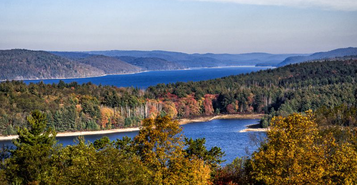
Numbers on paper rarely capture the true scale of the Quabbin Reservoir, but a few comparisons help put things in perspective. The reservoir covers approximately 39 square miles of surface area and has a shoreline that stretches for more than 180 miles.
At full capacity, it holds about 412 billion gallons of water, making it one of the largest domestic water supplies in the entire United States that was created specifically for a metropolitan area. The average depth of the reservoir is around 51 feet, though some sections reach much deeper.
The watershed that feeds the reservoir covers roughly 186 square miles. Strict land management policies protect this watershed, which is why so much of the surrounding area remains forested and undeveloped.
From the observation tower at Quabbin Summit, the water appears to stretch endlessly in multiple directions, broken only by small wooded islands. Many of those islands are former hilltops from the Swift River Valley that were simply too tall to be fully submerged.
The Observation Tower and Summit View

At the top of Quabbin Hill, a stone observation tower gives visitors one of the most expansive views available anywhere in central Massachusetts. The tower is part of the Quabbin Reservation, which is managed by the Massachusetts Department of Conservation and Recreation.
The drive up to the summit area is accessible by car, which makes it a practical option for those who want the view without committing to a long hike. From the top of the tower, the reservoir spreads out across the landscape in multiple directions, with forested hills framing the water on all sides.
On a clear day, the horizon seems to go on indefinitely, and the scale of what was built here becomes much easier to appreciate. The islands scattered across the water are former hilltops, remnants of the landscape that existed before the flooding began.
The tower itself is a simple but sturdy stone structure that fits naturally into the landscape. It has become one of the most photographed spots at the entire reservation.
Hiking Trails Across More Than 55,000 Acres

The Quabbin Reservation encompasses more than 55,000 acres of protected land, making it one of the largest tracts of undeveloped forest in southern New England. This land base supports an extensive network of trails ranging from easy paved paths to more demanding backcountry routes.
The paved trail near the Winsor Dam area is a popular starting point for casual walkers and families. For those looking for a longer outing, trails branch off into the deeper sections of the forest, where the terrain becomes more rugged and the crowds thin out considerably.
Hank’s Meadow is another well-known access point that offers a quieter approach to the water through open meadow terrain. The trails in this area tend to be relatively flat and accessible for most fitness levels.
Wildlife sightings are common throughout the reservation, with deer, wild turkeys, and a variety of bird species regularly spotted along the trails. Black bears have also been documented in the more remote sections, so making noise while hiking is a practical precaution worth keeping in mind.
Fishing and Boating Rules at the Reservoir

Fishing at the Quabbin Reservoir is a well-established tradition, but it comes with a specific set of regulations designed to protect the water quality and the fish population. The reservoir is home to lake trout, landlocked salmon, smallmouth bass, and various other species that attract serious anglers from across the region.
A Massachusetts fishing license is required, and there are designated areas where fishing from shore or from a boat is permitted. Boat rentals are available at the reservation during the fishing season, and private boats must meet specific requirements before being allowed on the water.
The fishing season typically runs from late April through October, though specific dates and rules can change from year to year. Checking the Massachusetts Division of Fisheries and Wildlife website before a trip is strongly recommended to avoid any surprises at the gate.
The reservoir’s clean, cold water supports a healthy fish population, and the lake trout fishing in particular has a strong reputation among anglers throughout New England. Early morning outings tend to produce the most consistent results.
The Relocated Cemeteries and What They Represent

Before the Swift River Valley was flooded, the Metropolitan District Commission undertook the difficult task of relocating the remains from dozens of cemeteries across the four towns. This was not a small operation.
An estimated 7,500 sets of remains were moved from local burial grounds to the Quabbin Park Cemetery in Ware, Massachusetts.
The Quabbin Park Cemetery was specifically established to receive these relocated remains. Headstones and grave markers from the original cemeteries were transferred as carefully as conditions allowed, and the cemetery remains open to the public today.
For descendants of families from Dana, Enfield, Greenwich, and Prescott, the cemetery represents a tangible connection to a past that no longer exists in any other physical form. Many families make periodic visits to locate the graves of ancestors who once lived in the valley.
The relocation of cemeteries is one of the more sobering chapters in the Quabbin story, serving as a reminder that the creation of this water supply came at a real human cost that extended well beyond property and economics.
Wildlife and the Protected Watershed Forest

One unexpected outcome of flooding the Swift River Valley and restricting public access to much of the surrounding land is that the Quabbin area has become a significant wildlife sanctuary. The protected watershed forest now supports populations of species that are rarely found in such numbers elsewhere in Massachusetts.
Bald eagles are among the most celebrated residents. The Quabbin Reservoir has been a key site in the recovery of bald eagle populations in New England, with nesting pairs observed in the area since the 1980s.
Winter months bring the largest concentrations of eagles, drawing birdwatchers from across the region.
White-tailed deer, wild turkeys, coyotes, river otters, and black bears all occupy the forested land surrounding the water. The absence of heavy development across such a large area has allowed these populations to thrive in ways that are uncommon this close to a major metropolitan region.
The Massachusetts Department of Conservation and Recreation manages the land with water quality and wildlife protection as dual priorities, which has resulted in one of the healthiest forest ecosystems in the state.
Visiting the Quabbin Today: What to Know Before You Go

The Quabbin Reservoir is located in central Massachusetts, with the main visitor area and Winsor Dam accessible from Route 9 in the town of Belchertown. The reservation is managed by the Massachusetts Department of Conservation and Recreation, and there is no admission fee to enter the main areas.
Several access points are spread across the reservation, with some offering restroom facilities and others providing only parking and trail access. The area near the Winsor Dam is the most developed and tends to be the busiest, especially on weekends.
Tick awareness is an important practical concern throughout the reservation. Long sleeves, tick repellent, and a thorough check after any trail walk are standard precautions for anyone spending time in the wooded areas, particularly along shoreline trails during warmer months.
The reservation is open year-round, and each season offers a different character. Fall foliage draws large numbers of visitors, winter allows for snowshoeing on certain trails, and spring brings active wildlife and migratory birds.
Planning ahead and checking current access rules on the DCR website helps make any visit go smoothly.
The Four Towns That Disappeared Beneath the Water

By 1938, the towns of Dana, Enfield, Greenwich, and Prescott had simply ceased to exist on any official map of Massachusetts. The state legislature passed the Swift River Act in 1927, setting the legal groundwork for what would become one of the most dramatic land-use decisions in New England history.
Roughly 2,500 residents were forced to leave homes their families had occupied for generations. Businesses closed, schools shut down, and community institutions that had operated for over a century were dismantled almost overnight.
The disincorporation ceremony held in Enfield Town Hall on April 27, 1938, drew hundreds of former residents who gathered to mark the official end of their towns. Some accounts describe it as a formal farewell, complete with music and speeches.
The physical structures were either demolished or burned by the Metropolitan District Commission. What could not be removed was left to be covered by rising water.
The Swift River Valley was gone, replaced by what would become a regional lifeline.


