
A powerful winter storm is bearing down on the Northeast, and the timing could not be more disruptive. Forecasts point to widespread double digit snowfall for major cities along I-95, including Washington, D.C. and New York City.
You will want to lock in your plans now, because heavy snow, strong winds, and dangerous roads are likely through Monday morning. Stay with this guide to know what to expect and how to prepare confidently.
A sprawling winter storm is set to unload over a foot of snow across the Northeast, with the bullseye aligned along the I-95 corridor. Long range guidance shows the system surging in late Saturday and peaking Sunday, with one inch per hour rates in the heavier bands.
You will notice visibility dropping fast as wind and powdery snow combine to create near whiteout bursts.
Winter Storm Warnings stretch from Washington, D.C. to Boston, a corridor that has not seen foot plus totals in many years. Plow crews will struggle to keep up when snow rates spike, so expect rapidly worsening conditions on interstates and secondary roads.
If you must travel, plan for extra time, pack warm gear, and keep your gas tank close to full.
Airports face significant delays and cancellations as crosswinds and runway accumulation slow operations. Airlines may issue waivers, so rebook early if your schedule is flexible.
By Monday morning, the heaviest snow should pull offshore, but clean up and lingering slick spots will still pose hazards for the commute.
The D.C. region is bracing for 7 to 14 inches of snow, with heavier totals northwest of the Beltway where colder air lingers. As the storm matures, sleet and freezing rain may mix south and east of the city, glazing roads and sidewalks.
You should expect treacherous travel, downed branches, and sporadic power outages in the harder hit zones.
States of emergency in D.C., Maryland, and Virginia underscore the storm’s high impact potential. The National Weather Service has a winter storm warning from late Saturday through early Monday, covering heavy snow, sleet, and patches of freezing rain.
Stock essential supplies, charge devices, and secure outdoor items that could blow or ice up.
When snowfall intensifies, stay off the roads so plows and salt crews can work. If you must drive, reduce speed, increase following distance, and avoid sudden braking on bridges and ramps.
After the snow, expect refreezing overnight and slower cleanup in neighborhoods where ice crusts over the surface.
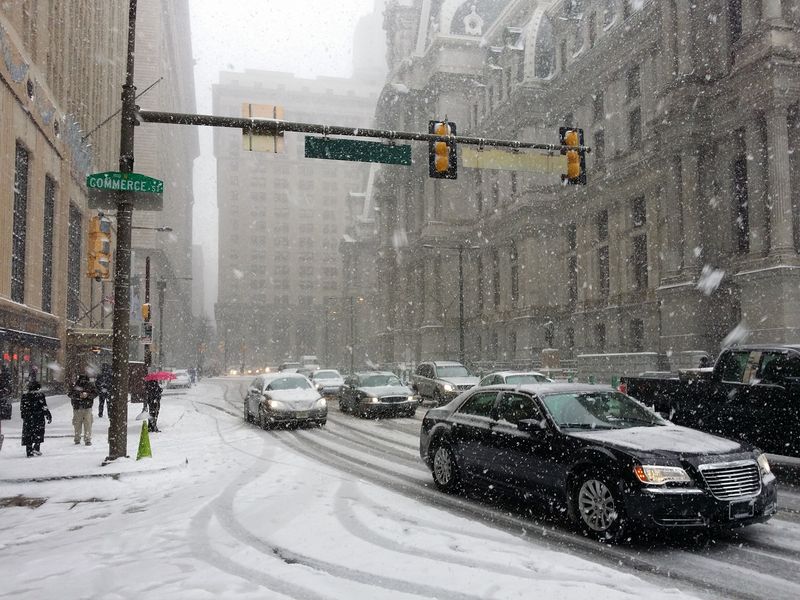
New York City is on track for 6 to 10 inches or more, with localized double digit totals if the storm slows overhead. Snow likely begins Sunday morning and persists into early Monday, complicating evening and next day commutes.
You should anticipate reduced visibility, slick intersections, and disruptions across subways, buses, and airports.
Forecast confidence is improving even as the storm track remains a key variable. Northern New Jersey and the city’s northern suburbs could jackpot if banding stalls.
Check updated forecasts every few hours, because small track shifts can change totals and timing for your neighborhood.
Philadelphia to Boston also faces heavy snow, with widespread plow operations and flight cancellations probable. Clear walkways in stages to prevent ice buildup and strain, and use sand or salt on steps and driveways.
By Monday, cleanup will continue as secondary streets get attention and winds drift snow back onto cleared lanes.
After the snow ends, Arctic cold settles in and keeps everything icy. Daytime temperatures struggle, and overnight lows refreeze slush into hard pack, extending hazards well beyond the final flakes.
You will want to treat sidewalks and driveways repeatedly, since sun glare can hide black ice on seemingly dry surfaces.
This storm arrives in an active pattern, with widespread winter alerts and persistent northern air. Cold snaps like this can tax infrastructure, from transit delays to frozen pipes in poorly insulated spaces.
Conserve energy, check on neighbors, and keep pets indoors while wind chills bite.
Officials warn of power outages, blocked roads, and prolonged school or transit disruptions into next week. Prepare extra water, shelf stable food, flashlights, and batteries before conditions deteriorate.
Limit travel during the coldest nights, and watch for falling ice from roofs and overpasses as partial melt refreezes overhead.


