A sprawling winter storm is rewriting the rulebook, pairing deep Arctic cold with spring-like thunderstorm energy along the Gulf Coast. While snow and ice hammer inland communities, warm Gulf moisture is fueling severe storms that may spin up tornadoes from Louisiana to the Florida Panhandle.
Millions are under threat for damaging winds, large hail, and fast-changing conditions that can escalate in minutes. Here is what to know, why it is happening, and how to stay safe as hazards rapidly evolve.
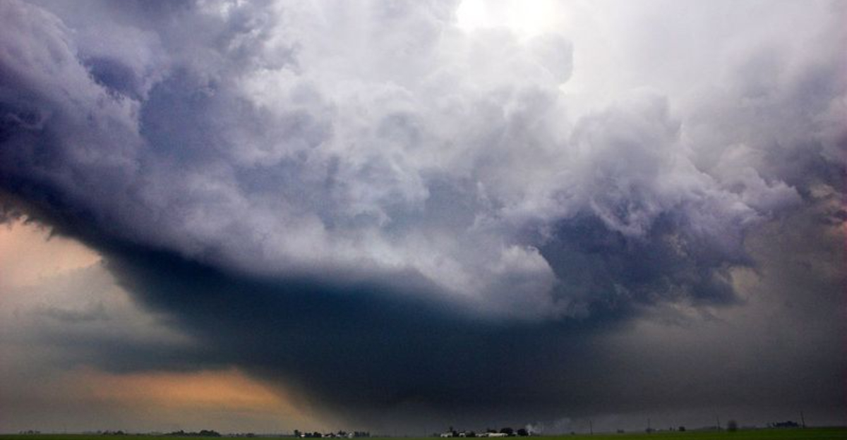
Historic Winter Storm Threatens Gulf Coast With Severe Weather and Tornado Risk
A powerful winter storm is surging across the United States, merging snow and ice with severe thunderstorms along the Gulf Coast. You can expect a volatile clash where warm, moisture-rich Gulf air meets an advancing Arctic front.
This zone favors damaging winds, pockets of large hail, and a few tornadoes, especially from south Louisiana through coastal Mississippi, Alabama, and the Florida Panhandle.
Forecasters say the storm’s northern flank will lay down heavy snow and glaze roads with freezing rain. Closer to the coast, the atmosphere becomes primed for rotating storms as wind shear and instability briefly overlap.
Nearly 10 million people fall within the severe threat corridor, where rapid storm development could bring hazards with limited warning.
This is a classic dual-hazard setup that demands attention even outside snow zones. If you are in the warm sector, be ready for sudden warnings, surging squall lines, and quick tornado spin-ups.
Inland, plan for treacherous travel, scattered power outages, and dangerous wind chills, as the system’s breadth magnifies risks across the Deep South.
Severe Thunderstorms Possible Where Winter Meets Spring-Like Instability
Severe storms can blossom when frigid air aloft slides over warm, humid surface air, sharpening instability and wind shear. That is the setup along the Gulf Coast as an Arctic boundary undercuts a moisture-rich air mass.
The tug-of-war supports rotating updrafts, quick-hitting supercells, and bowing line segments that can produce damaging wind and isolated tornadoes.
Expect the highest risk where temperatures and dew points remain elevated just ahead of the front, particularly across southern Louisiana into coastal Mississippi and Alabama. Even a narrow corridor of surface-based instability can be enough.
When low-level jets strengthen near dusk, storms may intensify as shear increases.
Winter tornadoes are less common but far from impossible. The Storm Prediction Center often highlights such setups when Gulf moisture noses inland beneath fast midlevel flow.
If you are in the warm sector, monitor updates frequently, since brief windows of favorable overlap can transform routine thunderstorms into severe weather with little notice.
Gulf Coast Has History of Rare Winter Storms With Mixed Threats
The Gulf Coast occasionally endures rare storms that pair snow and ice with severe weather. In January 2025, a historic system delivered blizzard-like conditions in parts of Louisiana to the Florida Panhandle.
Cities like Mobile and Pensacola saw snowfall totals that shattered local records, transforming typically mild landscapes into winter scenes while nearby thunderstorms flashed offshore.
That event echoed today’s dynamics, with Arctic air surging south as subtropical moisture streamed north. The resulting temperature contrasts fueled everything from slick roads to thunder-snows and sporadic coastal squalls.
Such mixed hazards stretch resources and complicate forecasting, especially where rain-snow lines wobble near population centers.
While heavy snow dominates farther inland, the coastal ribbon often faces a different danger: severe thunderstorms capable of quick tornadoes. History shows that even short-lived instability can be enough.
If you live along the Gulf, treat these hybrid events with caution, because impacts can vary block by block and escalate quickly as the storm evolves.
How Residents Can Stay Safe Amid Dual Weather Hazards
Preparation is your best defense when winter hazards combine with severe storms. Keep multiple ways to receive warnings, including a NOAA weather radio, phone alerts, and local broadcasts.
If a tornado warning is issued, move quickly to a small interior room on the lowest level, away from windows, and protect your head.
Charge devices, secure outdoor items, and assemble an emergency kit with flashlights, spare batteries, first aid, water, snacks, and needed medications. Travelers should check road conditions, avoid bridges and elevated roadways during icing, and never drive through flooded areas.
Power outages may follow heavy ice or damaging winds, so have blankets and safe heating options ready.
Review your plan with family now, not when warnings arrive. Identify sturdy shelter locations at home, work, and school, and consider pets in your checklist.
Monitor National Weather Service updates frequently, since timing and risk zones can shift as fronts accelerate and instability windows open.


