Nor’easters are the East Coast’s most dramatic weather makers, and you feel their punch when wind, waves, and heavy precipitation converge. You might hear the term every winter, but the mechanics behind these storms are as fascinating as they are formidable.
Understanding how they form and why they intensify helps you plan smarter and stay safer when forecasts turn ominous. Stick with this guide to see what drives these systems, the types to watch, and why timing matters most.
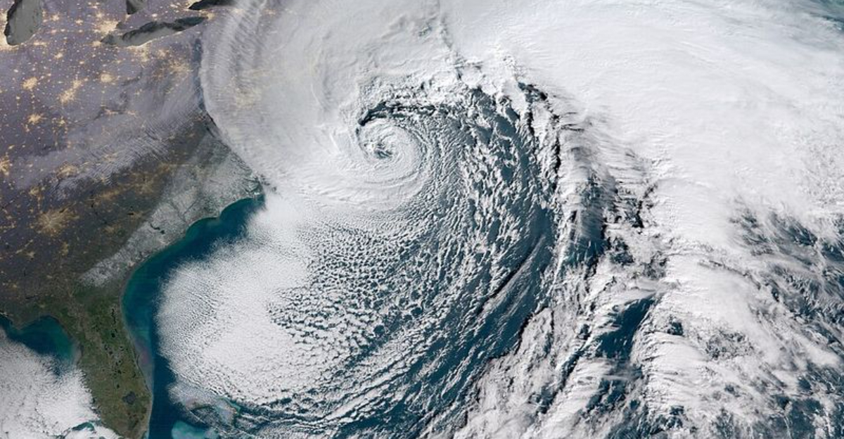
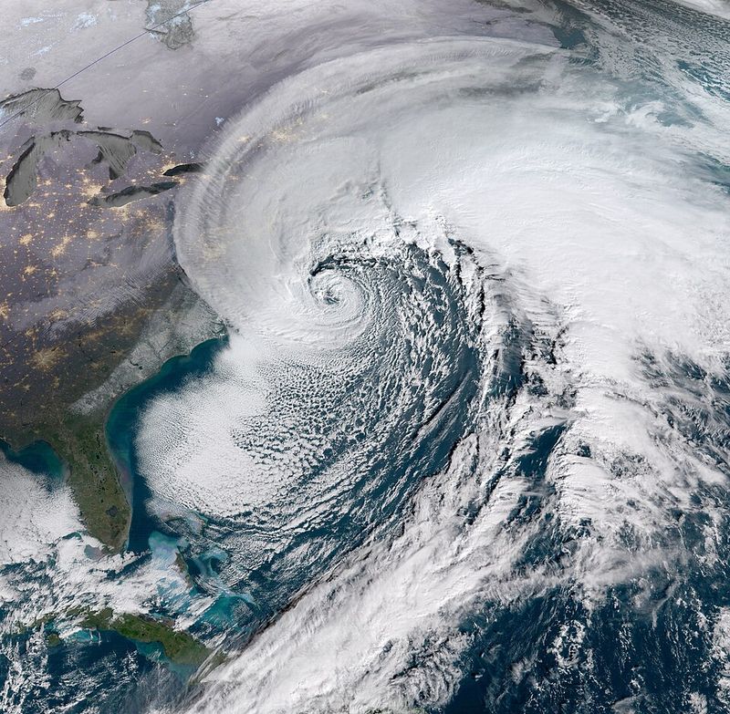
A nor’easter is a coastal storm defined by sustained northeast winds blowing onshore from the Atlantic, funneling moisture into cold air over the Eastern Seaboard. You notice it in the wind direction first, then the surge of precipitation that can flip from rain to heavy, pasty snow.
The corridor from Washington D.C. to Boston sits squarely in its crosshairs, with travel disruptions and coastal flooding common.
These storms can appear year round, but the stretch from September through April is prime time. That is when chilly continental air collides with relatively warm ocean waters, energizing a developing low pressure.
The result is a tightening pressure gradient that ramps up winds, rough seas, and hazardous surf.
Formation commonly occurs within roughly 100 miles of the coast from Georgia to New Jersey, before tracking northeast toward New England and the Canadian Maritimes. Impacts vary by temperature profile and storm intensity, swinging between wind driven rain and blockbuster snow.
When the ingredients align, you get long lasting gales, power outages, and coastal erosion that reworks beaches and barrier islands.
Nor’easters thrive on contrast. Cold, dry Canadian air spills south along the polar jet, while warm, moist air rides the Gulf Stream just offshore.
Where they meet, rising warm air and descending cold air generate lift, clouds, and precipitation, sharpening a coastal front that seeds a low pressure center.
As the low forms, it feeds on oceanic heat and moisture, deepening through baroclinic processes. You can picture the isobars tightening like a spinning top, steepening pressure gradients that accelerate northeasterly winds.
This interaction often peaks near New England, where shelf waters meet the Gulf Stream’s edge.
Storms then ride the jet like a conveyor, tracking up the coast and intensifying over the Atlantic. The exact path dictates who sees rain, snow, or a messy mix, depending on the vertical temperature profile.
Add in coastal geometry and tides, and you get a recipe for surge, beach erosion, and pounding surf that can last for days.
Meteorologists classify nor’easters by origin and track, often using the Miller system. A Miller Type A forms near the Gulf or Southeast coast and rides the shoreline, tapping deep moisture for widespread snow and high winds inland.
These are your classic blockbuster storms that can deliver blizzard conditions if cold air is locked in.
Miller Type B involves an inland low that transfers energy to a new coastal low near the Mid Atlantic. That handoff can create sharp gradients, with heavy snow west and mixed precipitation near the coast.
Other variants, including less common Type E setups, reflect unique interactions with upstream troughs and blocking.
Impacts range from coastal flooding and beach erosion to tree damage and prolonged power outages. The outcome hinges on timing, track, and thermal profiles through the column, which decide rain, snow, or sleet.
When the ingredients synchronize, these storms can rival hurricanes in duration and cost, hammering infrastructure and snarling travel along I 95.
Nor’easters matter because they strike densely populated corridors where infrastructure, transit, and coastal property sit exposed. Heavy snow grinds highways and rails to a halt, while gale force gusts topple trees onto lines and rooftops.
Alongshore, prolonged onshore flow piles water into bays, pushing tides past thresholds that flood streets and basements.
Peak season runs late fall through early spring, when cold air undercuts warm Atlantic waters to supercharge low development. Even outside winter, these storms can deliver soaking rain and dangerous surf, reminding you that snow is optional for a nor’easter.
What is mandatory is that persistent northeast wind signature tied to the storm’s pressure field.
Preparation pays: track forecasts, know your flood zones, and time travel around the worst bands. Secure loose items, charge devices, and keep layers, batteries, and medications handy.
Communities that plan for surge, snow removal, and prolonged outages ride out the blows with fewer disruptions and faster recoveries.


