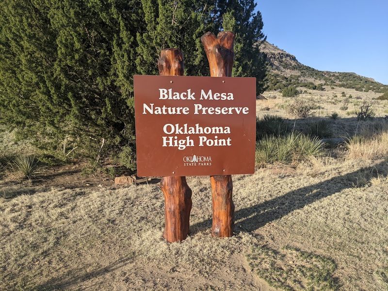
There is a trail in the far western corner of Oklahoma that ends at a stone obelisk standing on top of an ancient mesa, and the story of how you get there is just as good as the destination itself. The Black Mesa Trail covers roughly 8.4 miles round trip, climbing through open plains and prehistoric rock before reaching the highest point in the entire state.
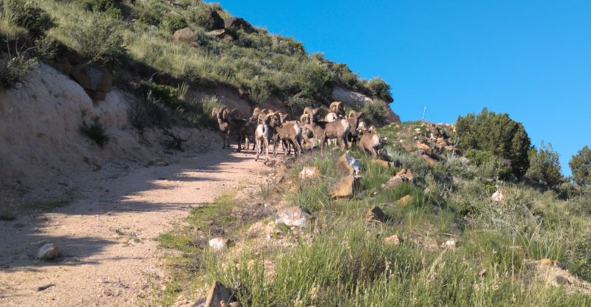
Along the way, you might spot bighorn sheep, giant orange crickets, or a desert ram wandering across the path like it owns the place. This trail has a 4.8-star rating from over 100 hikers, and once you read what makes it special, you will understand exactly why people drive hours just to walk it.
Where the Trail Begins: Address, Location, and First Impressions
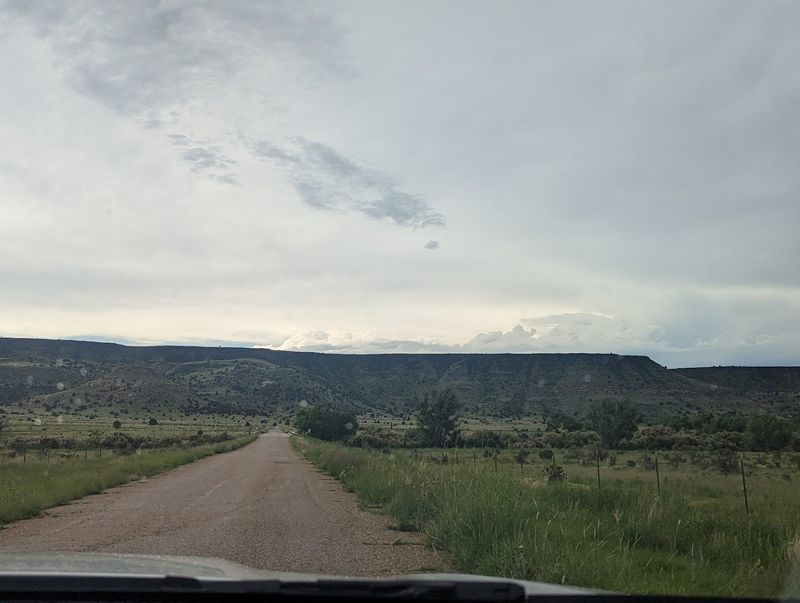
The Black Mesa Trail trailhead sits at the end of Black Mesa Trail road in Kenton, Oklahoma 73946, a tiny town tucked into the far northwestern panhandle of the state near the borders of New Mexico and Colorado. Getting there takes commitment.
The nearest major highways are miles away, and the last stretch of road is a long, quiet drive through open ranchland that makes the destination feel truly earned.
The trailhead itself is clean and well-organized. A restroom is available right at the start, which matters a great deal since there are no facilities anywhere along the 4.2-mile route to the summit.
A small parking area handles the modest crowds this remote spot draws, and informational signage greets you before you take your first step.
The trail is open 24 hours every day of the week, though hiking after dark is not recommended since the terrain becomes tricky without daylight. Most experienced visitors suggest arriving before 7 a.m. to beat the heat and make the most of the morning light.
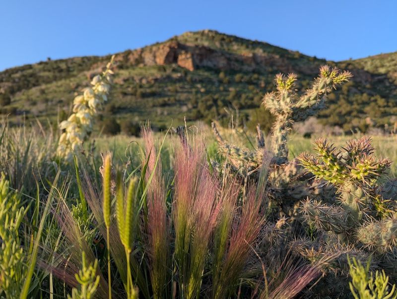
First impressions here are honest and direct: wide, flat land, a clear path, and a mesa rising in the distance that silently dares you to come closer.
The Prehistoric Roots Beneath Your Boots
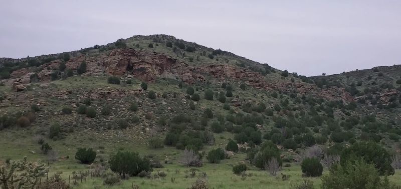
Black Mesa is not just a hill. It is the remnant of a massive lava flow that poured across this landscape roughly 30 million years ago, and the dark basalt rock capping the mesa is the direct result of volcanic activity from what is now Capulin Volcano in New Mexico.
That connection between fire, rock, and time is something you can actually see and touch as you climb.
The area around Black Mesa has also yielded some of the most significant dinosaur fossil discoveries in the southern Great Plains. Paleontologists have found the remains of sauropods, theropods, and other late Jurassic creatures in the Morrison Formation rocks nearby.
The land you are crossing has a history that stretches back more than 150 million years, which gives every step a quiet sense of weight.
Native American peoples also moved through this region for thousands of years, leaving traces of their presence across the panhandle landscape. The mesa served as a landmark and a boundary for many different groups over the centuries.
Walking the trail feels less like a day hike and more like a slow read through a very long book written entirely in stone, wind, and deep time.
Breaking Down the 8-Mile Route
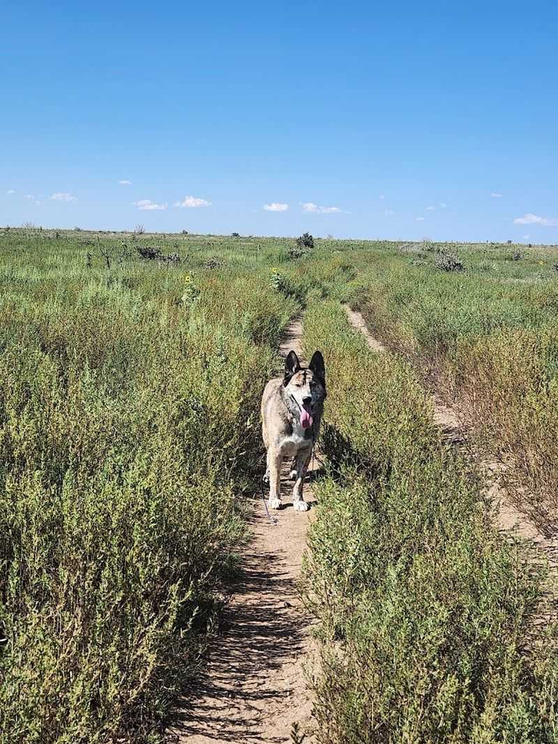
The full round trip clocks in at approximately 8.4 miles, and the layout is straightforward enough that even first-time visitors rarely get lost. The first 2.5 miles from the trailhead are almost entirely flat, crossing open grassland and ranch terrain at a comfortable pace.
This section is easy walking and gives you time to settle into your rhythm before things get more demanding.
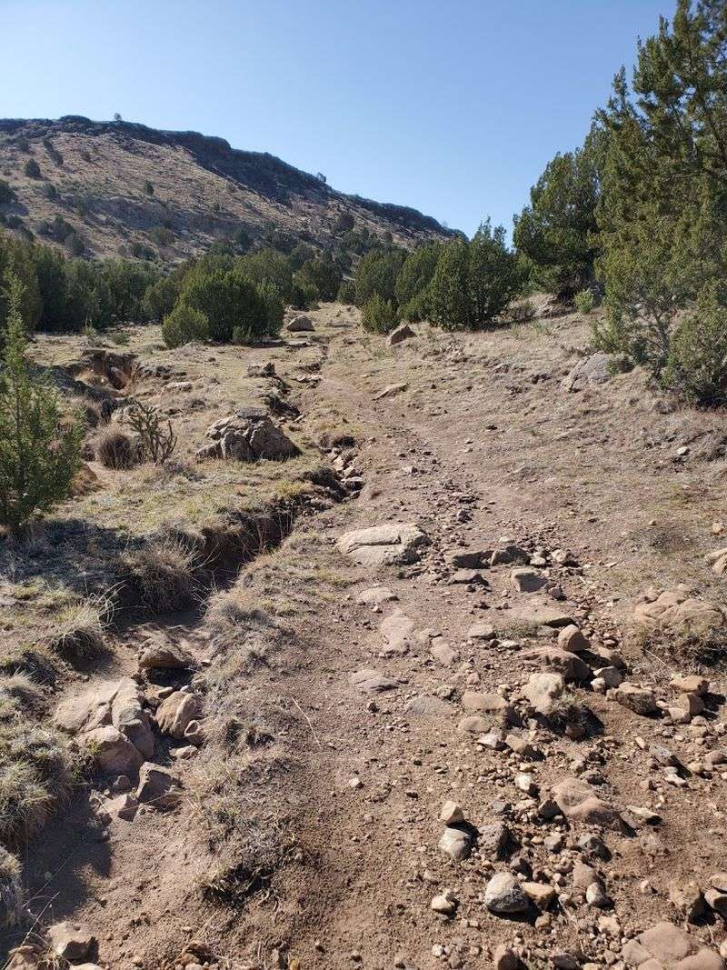
Around the 2.5-mile mark, the trail begins its steep one-mile ascent up the side of the mesa, gaining roughly 500 feet in elevation over that stretch. This is the section that separates a casual stroll from a genuine hike.
The incline is consistent and exposed, with no shade and loose rock underfoot in places, so trekking poles are a smart addition to your pack.
Once you reach the top, the trail levels out again and continues for about another mile across the flat mesa surface to the high point monument. Benches placed roughly one mile apart along the lower sections offer welcome rest stops.
The total elevation change for the entire hike is listed at over 2,100 feet when accounting for the full out-and-back distance. Budget at least four hours, and more if you plan to linger at the top.
The Monument at the Summit
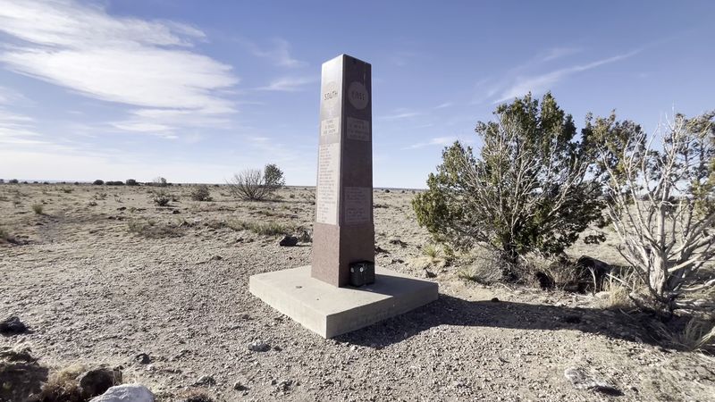
At the highest point in Oklahoma, standing at 4,973 feet above sea level, there is a granite obelisk that has been marking this spot for over 65 years. The monument is in remarkably good condition for its age, weathered but solid, and it carries inscriptions that give context to where you are standing.
Most hikers stop here for photos, a snack, and a moment of quiet satisfaction.
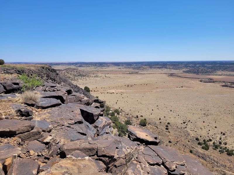
The obelisk marks the exact spot where Oklahoma, Colorado, and New Mexico share proximity, and on a clear day the view from this elevation is genuinely expansive. Look west from the monument and Capulin Volcano National Monument is visible on the horizon, a striking reminder of the volcanic forces that shaped this entire region.
The connection between the two landmarks is more than scenic; it is geological.
A short unofficial trail branching south from the monument leads to an overlook that many hikers consider the true highlight of the trip. Adding this detour brings the total distance to around 9.3 miles, but the views from the overlook edge are worth every extra step.
Standing at the rim and looking out over the unbroken expanse of the southern plains is one of those experiences that stays with you long after the drive home.
Wildlife You Might Meet Along the Way
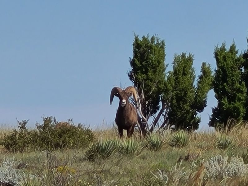
The wildlife encounters on this trail are one of its most talked-about features, and they happen more often than you might expect on a route this remote. Bighorn sheep have been spotted near the top of the mesa climb, particularly around the rocky outcroppings just as the trail levels out.
Seeing one of these animals up close, calm and unhurried, is the kind of moment that makes a hike feel like something more than exercise.
Desert rams have also been reported on the trail itself, wandering across the path with a confidence that suggests they are not particularly impressed by hikers. Rabbits dart through the brush along the lower sections, and the area is productive for birdwatching throughout the warmer months.
Raptors are frequently seen riding thermals above the mesa, and ground-nesting birds are common in the grassland sections.
Perhaps the most surprising resident of the trail is the giant orange cricket, which appears in numbers that catch most first-time visitors completely off guard. These large, bright insects are harmless but visually striking, especially when dozens of them are crossing the path at once.
Cattle also graze in the surrounding ranchland and occasionally wander close to the trail, adding a distinctly western character to the whole experience.
What to Expect From the Terrain and Conditions
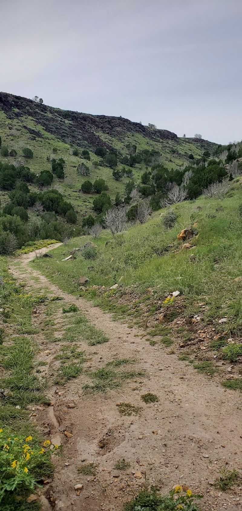
The trail surface changes noticeably as you move from the valley floor to the mesa top. The lower 2.5 miles follow what is essentially an old road, wide and well-worn, with a firm surface underfoot.
This section is comfortable and easy to navigate even for hikers who do not have a lot of trail experience under their belts.
The one-mile climb up the mesa is a different story. The path narrows and steepens, the footing becomes less predictable, and the exposure to sun and wind increases significantly.
There is no shade on this section or anywhere else on the trail, which makes the time of day you choose to hike a genuinely important decision rather than a minor detail.
Wind is a constant companion at Black Mesa, and it can shift from a pleasant breeze to a forceful gust without much warning. Temperatures on the exposed mesa top can feel dramatically different from the valley below, both hotter in direct sun and colder when storm systems move through.
The terrain is dry and demanding in summer, more forgiving in spring and fall, and potentially icy in winter. Solid footwear, sun protection, and a weather check before you leave are non-negotiable parts of the plan.
Water, Weather, and Staying Safe Out There
Water is the single most important thing to get right before you set foot on this trail. The consensus from experienced hikers is clear: bring at least two to three liters per person under normal conditions, and up to six liters when temperatures climb into summer ranges.
The trail is fully exposed from start to finish, and dehydration can sneak up quickly when the sun is high and the wind is dry.
Covered benches are spaced along the route below the mesa, and a handful of these have emergency water supplies attached. These are genuinely emergency resources and should not factor into your planning as a reliable source.
Treat them as a last resort, not a convenience, and carry everything you need from the trailhead.
Thunderstorms are a real hazard at this elevation and in this part of Oklahoma, where weather can build fast and move faster. Being on top of an exposed mesa during a lightning storm is a serious situation, so checking the forecast before you hike is not optional.
Starting early in the morning reduces both heat exposure and the risk of afternoon storm activity, which is the pattern most common in summer months. Dogs are welcome on the trail but need just as much water as their human companions, sometimes more.
Best Times to Visit and Seasonal Notes
Spring and fall are the seasons that bring out the best version of this trail. Temperatures are moderate, the light is softer, and the landscape has more color and life than the bleached summer months.
Spring in particular can produce wildflowers along the lower trail sections, and the birdlife is noticeably more active when the weather is mild and conditions are right.
Summer hiking is possible but demands serious preparation. The heat in the Oklahoma panhandle is not gentle, and the complete lack of shade on this trail turns a warm morning into a punishing afternoon very quickly.
Anyone planning a summer visit should aim to be back at the trailhead before noon if possible, which means starting well before sunrise in some cases.
Winter visits are less common but not unheard of, and they come with their own rewards. The trail is quieter, the air is crisp, and the views are unobstructed by heat haze.
However, ice on the mesa climb is a genuine concern after precipitation, and cold wind at the summit can make a mild-seeming day feel much more serious. A gray, overcast day in early spring or late fall is probably the least rewarding version of this hike, since the landscape reads as flat and colorless without good light to animate it.
The Solitude Factor: A Hike That Rewards the Patient Traveler
Kenton, Oklahoma is not exactly a hub of tourist activity. The town has a population that barely registers on most maps, and the drive to the trailhead involves long stretches of road where the only company is the occasional passing truck or a hawk perched on a fence post.
That remoteness is precisely what makes this place so appealing to a certain kind of traveler.
On most days, the trail sees only a handful of visitors, and it is entirely possible to complete the full round trip without crossing paths with more than one or two other hikers. Solo hikers in particular find the experience deeply satisfying, with nothing but the sound of wind, footsteps, and occasional wildlife to fill the silence.
The mesa top, when you finally reach it, can feel like the edge of the known world.
That said, the trail’s remote character means that self-sufficiency is not just a hiking virtue here but a practical requirement. Cell service is unreliable to nonexistent in this part of the panhandle, so downloading offline maps before you leave is a smart move.
The reward for all this effort and preparation is a hike that feels genuinely yours, uncluttered by crowds and unmarred by noise.
Tips for Making the Most of Your Visit
A few practical details can turn a good hike into a great one out here. The trailhead restroom is the only facility on the entire route, so make use of it before you start.
Sunscreen is not optional on a trail with zero shade, and a hat with a wide brim makes a real difference over the course of a four-to-six-hour round trip in open sun.
Trekking poles are genuinely useful on the mesa climb, both for the ascent and for protecting your knees on the way back down. Sturdy trail shoes or light hiking boots with good grip handle the varied surfaces better than running shoes, especially on the rocky upper section.
A small first aid kit, a fully charged phone with offline maps loaded, and a light layer for the summit wind round out a solid gear list.
The unofficial overlook trail south of the monument is worth the extra mileage if your legs have anything left. Plan the drive to Kenton as part of the adventure rather than an inconvenience, since the panhandle scenery on the approach is striking in its own right.
Oklahoma has plenty of trails, but very few of them end at a spot that carries this much history, geology, and hard-won satisfaction in a single stone marker.


