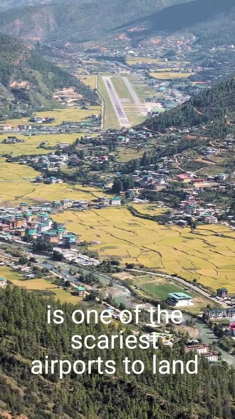
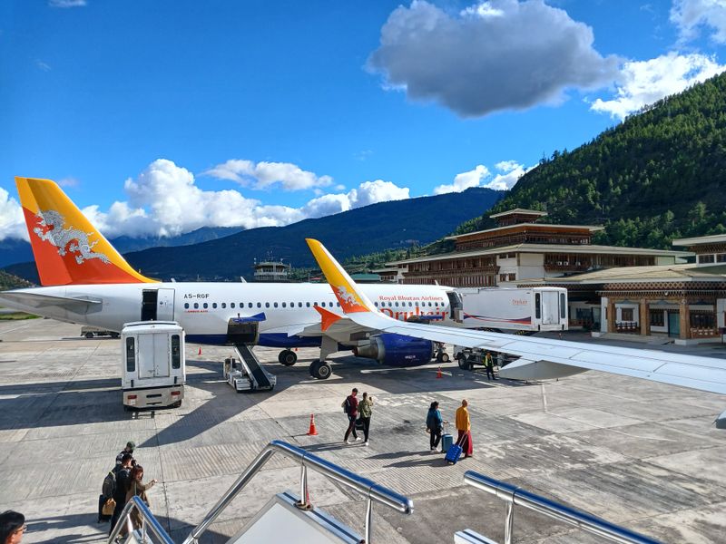
Landing in Bhutan is not your average flight story. Paro Airport is one of the toughest places on Earth to touch down, and you feel that the second the mountains close in. There’s no wide open runway, no easy approach over water or flat fields.
Paro sits inside a tight valley, surrounded by Himalayan peaks that leave pilots almost no room for error. That’s why only a small group of specially certified pilots are allowed to land here. And the wild part is this: every arrival isn’t just a landing.
It’s a controlled descent through a wall of mountains, where experience matters more than nerves.
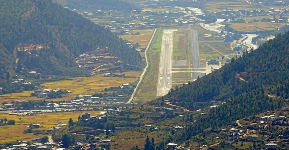
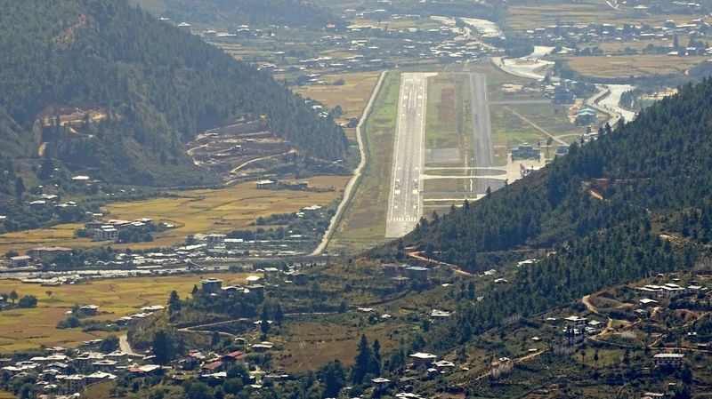
1. It’s literally carved into a deep valley
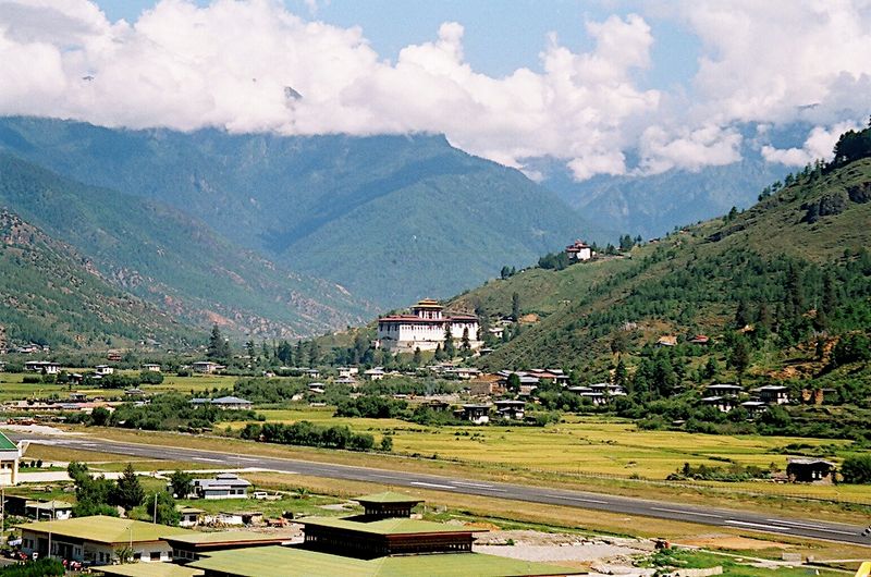
Threading a needle while riding a roller coaster is what pilots face when approaching Paro Airport, which sits along the Paro Chhu river in a valley so narrow that mountains crowd both sides. There’s no gentle, gradual descent here.
Instead, flight crews navigate a twisting path that follows the natural contours of the terrain. The valley walls rise steeply, leaving little room for error or improvisation.
Pilots must time their turns and altitude changes with surgical precision, relying on visual landmarks like monasteries, farmhouses, and river bends to stay on course.
This isn’t about following a straight instrument approach like at most international airports. The route demands constant attention and adjustment, with terrain rising uncomfortably close on all sides.
One wrong calculation could put an aircraft dangerously near a mountainside.
The river valley itself is beautiful, lush green in summer and golden in autumn, but that beauty comes with serious operational constraints. Weather patterns follow the valley’s shape, funneling wind and clouds in unpredictable ways.
For passengers, the approach offers stunning views of traditional Bhutanese homes and terraced fields, but for pilots, every moment requires total focus on the challenging geography that makes Paro one of aviation’s ultimate tests.
2. The altitude steals performance
At 2,235 meters above sea level, Paro sits higher than most ski resorts. That might not sound extreme compared to mountain peaks, but for aircraft, this elevation creates real complications.
Thin air means engines produce less thrust, wings generate less lift, and everything about the plane’s performance changes.
Pilots must account for these differences during every phase of flight. Takeoff requires longer runway distances because the aircraft needs more speed to achieve the same lift as at sea level.
Landing approaches demand careful speed management since the thinner air affects how the plane responds to control inputs.
The reduced air density also impacts braking effectiveness after touchdown. Tires and brakes work harder to stop the aircraft in the same distance, adding another layer of complexity to an already demanding operation.
Fuel calculations change too, since engines burn differently at altitude.
For crews trained at low-elevation airports, these differences feel significant. The aircraft simply doesn’t behave the same way it would in Bangkok or Singapore.
Weather compounds the challenge, as temperature variations at this elevation can swing wildly between morning and afternoon, further altering performance characteristics. This combination of factors means pilots must arrive at Paro with both theoretical knowledge and practical experience handling high-altitude operations in mountainous terrain.
3. Mountains rise up to 5,500 meters around it
Standing at the bottom of a massive bowl carved from the Himalayas, is Paro’s reality. Peaks surrounding the valley climb to roughly 5,500 meters, creating walls of rock and ice that dwarf the airport below.
These aren’t distant mountains on the horizon, they’re immediate, looming presences that dominate every sightline.
This extreme elevation difference creates what aviation experts call “limited escape routes.” If something goes wrong during approach, pilots have very few options for maneuvering away from terrain. At most airports, a pilot can simply climb straight ahead or turn in almost any direction to find safe airspace.
Not here.
The mountains channel aircraft into specific corridors, leaving little room for deviation. Weather can hide these peaks behind clouds, making visual navigation even more critical.
Pilots must maintain constant awareness of their position relative to terrain, using landmarks to confirm they’re tracking the correct path through the valley.
For passengers, the view is breathtaking, literally. Snow-capped summits gleam in sunlight, and the sense of scale is almost overwhelming.
But that same beauty represents serious operational constraints. The mountains don’t negotiate or forgive mistakes.
They simply exist as permanent obstacles that demand respect, skill, and perfect execution from every flight crew attempting to reach Paro’s runway.
4. Landings are restricted to daylight + good visibility
Forget red-eye flights or landing in foggy conditions. Paro operates under strict visual meteorological conditions only, meaning pilots must be able to see the terrain, runway, and landmarks throughout their approach.
No exceptions. Flights are limited to daylight hours, typically from sunrise to sunset, eliminating any possibility of night operations.
This restriction exists because the approach relies heavily on visual references. Pilots need to see specific mountains, valleys, and ground features to navigate safely through the terrain.
Instrument-only approaches, common at most international airports, simply aren’t feasible here given the complex topography.
Cloud cover, rain, or even haze can ground flights instantly. If visibility drops below minimums, aircraft either hold in safe airspace waiting for conditions to improve or divert to alternate airports in India or Bangladesh.
This happens regularly, making schedule reliability a challenge for airlines serving Bhutan.
The daylight-only rule also means flight schedules are seasonally dependent. Winter days are shorter, reducing the operational window.
Summer offers more flexibility but brings monsoon weather that can shut down operations for hours or days. Passengers booking Paro flights learn quickly to build flexibility into their travel plans.
The airport’s weather-dependent operations are non-negotiable, a reality that prioritizes safety over convenience and reminds everyone that nature still sets the rules in this corner of the Himalayas.
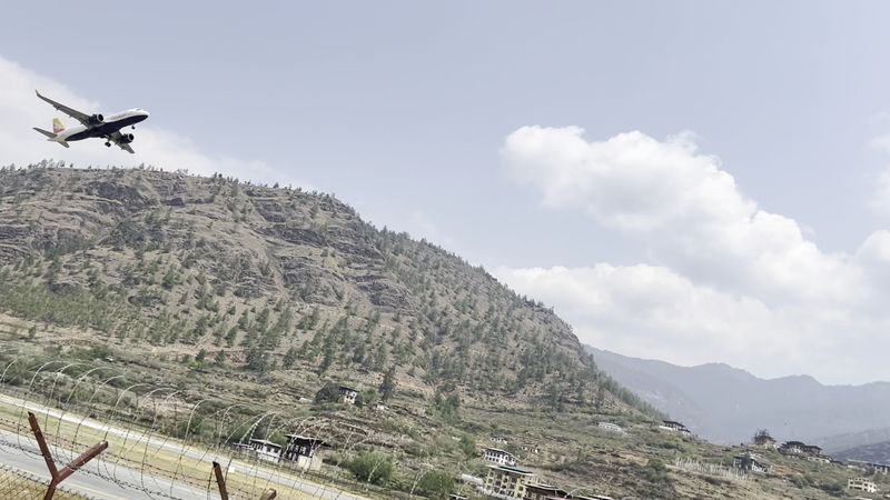
5. The runway is short by international-jet standards
Paro’s runway stretches about 2,265 meters, roughly 7,431 feet. That’s adequate for the aircraft types currently serving the airport, but it’s definitely on the shorter side compared to major international hubs.
Many large airports feature runways exceeding 10,000 feet, giving pilots plenty of room for less-than-perfect touchdowns.
Here, there’s minimal margin for error. Pilots must nail their approach speed and touchdown point.
A “floaty” landing, where the aircraft stays airborne longer than planned, can eat up precious runway distance. Combined with the altitude’s effect on braking performance, this creates a situation where precision isn’t optional, it’s essential.
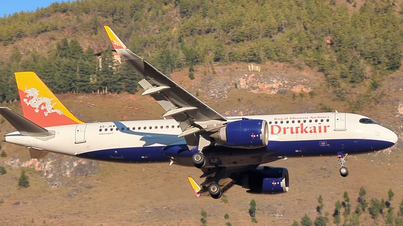
The runway length also limits which aircraft types can operate at Paro. You won’t see massive wide-body jets here.
Instead, airlines use smaller aircraft like the Airbus A319 or ATR turboprops, planes better suited to the runway’s dimensions and the valley’s operational constraints.
Weather affects usable runway length too. Tailwinds reduce effective stopping distance, sometimes forcing cancellations even when visibility is good.
Crosswinds add another complication, as the single runway doesn’t offer alternate directions like airports with multiple runways. For pilots, every landing at Paro requires treating the runway as a precious, limited resource.
There’s no room for complacency or sloppy technique when the pavement ends and mountain terrain begins just beyond the runway’s edge.
6. The approach is highly ‘hands-on’
Automation takes a back seat at Paro. While modern airliners can practically fly themselves at most airports, the approach here demands old-school piloting skills.
Crews hand-fly the aircraft through much of the arrival, making constant adjustments based on what they see outside the windscreen rather than what computers tell them.
This manual flying isn’t about showing off. The terrain simply doesn’t allow for standard instrument approaches that would let autopilots do the work.
Pilots must interpret visual cues, judge distances to mountains, and time their turns using landmarks like villages, temples, and ridgelines as reference points.
The mental workload is intense. Both pilots stay actively engaged, calling out terrain features, confirming positions, and cross-checking each other’s observations.
There’s no cruise-control phase where one pilot can relax while systems handle the flying. Every moment demands attention and precise control inputs.
This hands-on requirement is one reason certification for Paro takes serious training. Pilots must demonstrate they can handle the aircraft manually in challenging conditions, maintaining exact speeds and altitudes while navigating through terrain.
It’s a skillset that many modern pilots don’t practice regularly, since automation handles most flying at typical airports. Paro brings aviation back to fundamentals, where stick-and-rudder skills, judgment, and experience matter more than any computer system ever could.
7. You don’t see the runway ‘early’
Most airport approaches offer pilots a long, clear view of the runway from miles away. Paro doesn’t work that way.
Because of the valley’s twisting shape and surrounding mountains, the runway often stays hidden until surprisingly late in the approach. Pilots might not get a clear view until they’re already committed to landing.
This late visibility creates psychological pressure. There’s no gradual visual confirmation that everything’s lining up correctly.
Instead, crews must trust their navigation and positioning until the runway finally appears, sometimes feeling like it materializes suddenly around the final turn into the valley.
The terrain blocks sightlines in ways that can feel disorienting even for experienced pilots. Mountains don’t just surround the airport, they actively obscure it until aircraft reach specific positions in the valley.
This means pilots must have complete confidence in their approach path before visual confirmation arrives.
For passengers, this creates a unique experience. You might be looking at mountainsides and villages right up until the moment the runway appears beneath the aircraft.
It’s thrilling but can feel unsettling if you’re not expecting it. For pilots, managing this late visual acquisition requires mental discipline and trust in their procedures.
They can’t rely on early visual confirmation to reassure them everything’s correct. Instead, they must fly the approach perfectly, knowing the runway will appear exactly when and where it should if they’ve done everything right.
8. Weather can change fast in the valley
Mountain weather is notoriously fickle, and Paro’s valley is no exception. Conditions that look perfect can deteriorate within minutes as clouds roll in, winds shift, or visibility drops.
Pilots and air traffic controllers constantly monitor weather, knowing that what’s acceptable now might be problematic in fifteen minutes.
The valley’s shape creates its own weather patterns. Air flows through the narrow space in complex ways, generating turbulence, wind shear, and rapidly forming clouds.
Morning conditions often differ dramatically from afternoon weather, as temperature changes cause air to behave differently throughout the day.
Seasonal patterns add another layer of complexity. Monsoon season brings heavy rains and persistent clouds that can shut down operations for extended periods.
Winter offers generally clearer skies but shorter days and occasional snowfall. Spring and fall are typically the most stable seasons, though even then, surprises happen regularly.
Diversions are a regular occurrence. Pilots departing for Paro always file alternate airports in their flight plans, knowing there’s a real chance they won’t land in Bhutan on their first attempt.
Passengers learn to expect delays and cancellations as routine rather than exceptional. This weather unpredictability is simply part of Paro’s character, a reminder that mountain environments operate on their own schedule.
The airport doesn’t control the weather; it adapts to it, prioritizing safety over schedule reliability every single time.
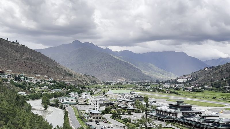
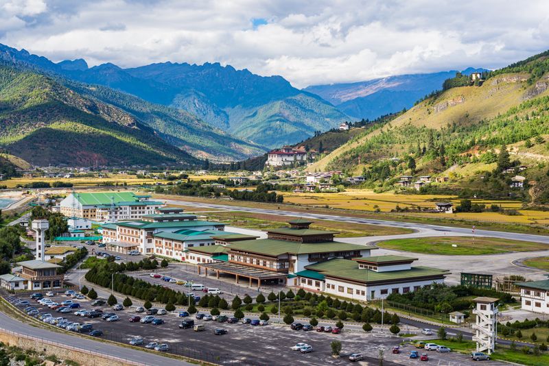
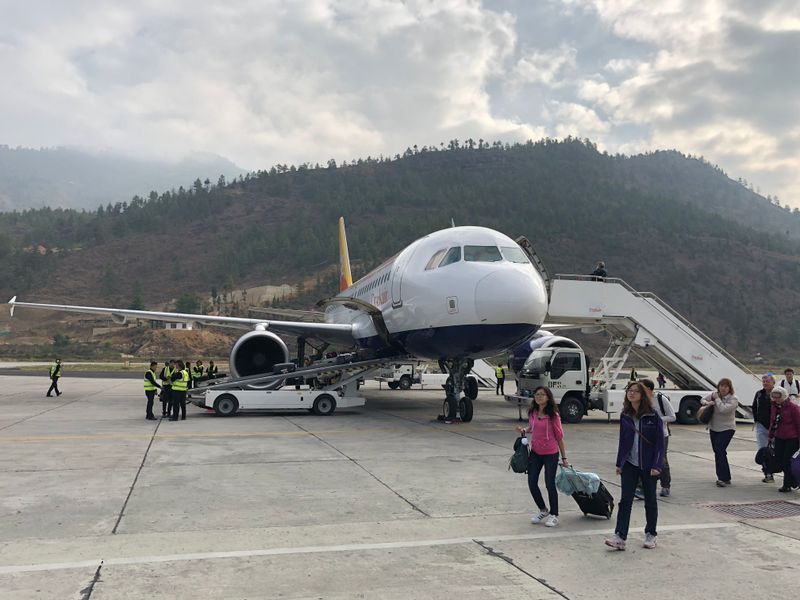
9. The airport is small by design

Paro Airport won’t be confused with Dubai or Singapore. The terminal is modest, almost quaint compared to sprawling international hubs.
There’s one runway, limited parking positions for aircraft, and a terminal that handles passenger volumes measured in hundreds rather than thousands per day. This isn’t an oversight, it’s intentional.
Bhutan has deliberately limited tourism and development to preserve its culture and environment. The airport reflects this philosophy.
By keeping operations small and controlled, authorities maintain safety standards while preventing the kind of mass tourism that might overwhelm the country’s infrastructure and traditions.
The terminal features traditional Bhutanese architecture, with colorful painted woodwork and design elements that reflect the nation’s Buddhist heritage. It’s beautiful in its simplicity, offering a stark contrast to the glass-and-steel anonymity of most modern airports.
Passengers often comment on the human scale of everything.
Limited capacity means flights are carefully scheduled and coordinated. There’s no rush-hour chaos or endless queues snaking through vast terminals.
Everything moves at a more measured pace, which suits the operational constraints perfectly. The small size also means less infrastructure to maintain in challenging mountain conditions.
It’s aviation scaled to fit the environment rather than trying to dominate it. For visitors, Paro Airport becomes their first introduction to Bhutan’s approach to development, measured, intentional, and respectful of both cultural values and natural limitations.
10. ‘Only 24 pilots’ is the famous claim but the real number depends on how you count
You’ve probably heard that only 24 pilots in the world can land at Paro. It’s the statistic that gets repeated constantly, giving the airport its mystique.
But like many aviation legends, the truth is more nuanced. Some sources cite closer to 50 certified pilots, while others stick with the lower number.
The confusion comes from how you count. Are we talking about currently active pilots?
Pilots certified on specific aircraft types? Pilots who maintain their Paro qualification versus those who’ve let it lapse?
The answer changes depending on these factors.
What’s definitely true is that the pool is extremely small and highly specialized. Airlines operating to Paro must ensure their pilots complete specific training, including simulator sessions and supervised landings.
Not every captain in an airline’s roster gets this certification, only those who’ll regularly fly the route.
The certification process is rigorous. Pilots study the approach extensively, memorizing landmarks, altitudes, and procedures.
They fly the route with experienced instructors before being cleared to operate independently. Some pilots maintain their qualification through regular flights, while others might be certified but not currently flying to Paro.
So while the exact number is fuzzy and varies by source, the core truth remains: landing at Paro requires special certification that only a select group of pilots possess, making it genuinely exclusive regardless of whether the number is 24, 50, or somewhere in between.
11. Tiger’s Nest (Paro Taktsang) – Bhutan’s iconic cliff monastery
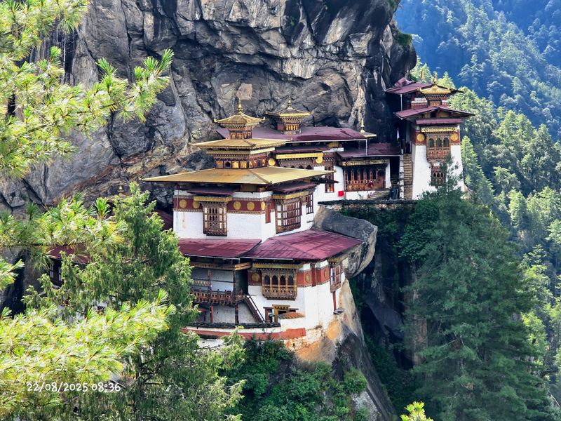
After experiencing the intense approach to Paro Airport, visitors often wonder what could possibly top that adrenaline rush. The answer hangs on a cliff face high above the valley: Tiger’s Nest monastery, or Paro Taktsang in Dzongkha.
This sacred Buddhist site clings to rock at roughly 3,120 meters elevation, looking like someone photoshopped a building onto an impossible location.
Legend says Guru Rinpoche flew here on a tigress’s back in the 8th century and meditated in a cave. Whether you believe the legend or not, the monastery’s location is genuinely jaw-dropping.
Buildings seem to grow directly from the cliff, connected by stairs carved into stone.
The hike takes most visitors three to four hours round trip, climbing through pine forests decorated with prayer flags. It’s challenging but manageable for anyone in reasonable fitness.
Horses can carry visitors partway up, though you’ll still walk the final steep section.
At the top, the views are extraordinary. The Paro valley spreads below, and on clear days, you can see forever.
The monastery itself is still active, with monks living and practicing there year-round. Visitors must dress modestly and respect the sacred nature of the site.
Photography is restricted in some areas. For many travelers, Tiger’s Nest becomes the highlight of their Bhutan visit, a place that somehow exceeds even the most dramatic photographs and fully justifies the journey to this remote Himalayan kingdom.
12. Rinpung Dzong (Paro Dzong) – fortress-monastery over the valley
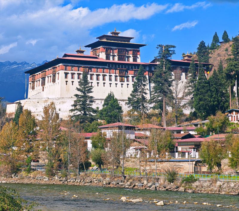
Dominating Paro town from its hillside perch, Rinpung Dzong represents everything quintessentially Bhutanese. This massive fortress-monastery complex serves dual purposes: spiritual center for local monks and administrative headquarters for the district.
The architecture alone justifies a visit, with massive whitewashed walls, intricately painted woodwork, and courtyards that seem frozen in time.
Built in 1644, the dzong has witnessed centuries of Bhutanese history. Its strategic position allowed defenders to control the valley below, while its religious significance made it a center of Buddhist learning and practice.
Today, it continues both functions, housing government offices and an active monastic community.
Visitors enter via a traditional covered bridge spanning the Paro Chhu river. Inside, you’ll find temples with elaborate murals, enormous prayer wheels, and courtyards where monks debate philosophy using traditional hand-clapping gestures.
The annual Paro Tshechu festival happens here, drawing thousands for masked dances and religious celebrations.
The dzong’s interior reveals Bhutanese craftsmanship at its finest. Every surface seems decorated with symbolic paintings, carved wood, or metalwork.
There are no nails in traditional Bhutanese buildings; everything is fitted together using precise joinery techniques. The atmosphere is both grand and intimate, powerful yet welcoming.
For visitors trying to understand Bhutanese culture, Rinpung Dzong offers insights into how religious and civic life interweave in this Buddhist kingdom, creating institutions that serve both spiritual and practical community needs.
13. Ta Dzong / National Museum of Bhutan — history in a watchtower
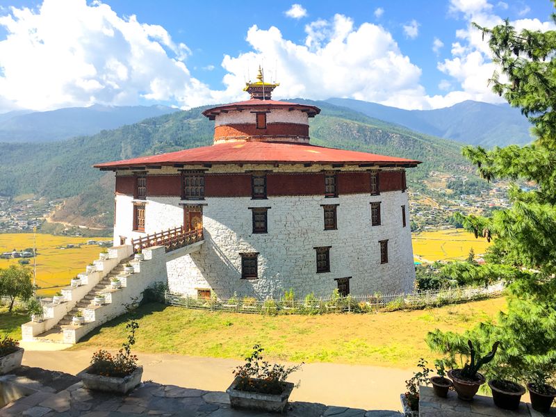
Perched directly above Rinpung Dzong sits Ta Dzong, a circular watchtower that once guarded the fortress below. Built in 1649, it served military purposes for centuries before being converted into Bhutan’s National Museum in 1968.
The building’s unique round shape makes it instantly recognizable against the valley’s landscape.
Inside, the museum houses an impressive collection that tells Bhutan’s story through artifacts, art, and exhibits. You’ll find ancient weapons, traditional costumes, religious thangka paintings, and natural history displays.
The collection helps visitors understand Bhutanese culture’s depth and complexity beyond the tourist-friendly surface.
One of the most fascinating sections covers Bhutanese postage stamps, which are famous worldwide for their beauty and innovation. Bhutan has issued stamps you can play like records, stamps that smell like roses, and 3D stamps.
It sounds quirky, but it reflects the nation’s creative approach to engaging with the modern world while maintaining tradition.
The museum’s layout follows the tower’s circular architecture, with exhibits spiraling upward through multiple floors. Windows offer spectacular views of the valley and Rinpung Dzong below.
The building itself, with its thick walls and strategic position, tells stories about medieval warfare and fortress design. For context before exploring Bhutan more widely, the National Museum provides essential background on the country’s history, art traditions, religious practices, and natural environment.
It’s compact but comprehensive, perfect for visitors wanting deeper understanding beyond surface-level tourism.
14. Easy day trips beyond Paro: Chele La + Thimphu highlights
Paro serves as an excellent base for exploring western Bhutan’s highlights. With a driver and guide (required for all tourists anyway), two destinations stand out as particularly rewarding.
Chele La Pass, sitting at 3,988 meters between Paro and Haa valleys, ranks among Bhutan’s highest motorable roads. The drive up winds through forests that shift from subtropical to alpine as elevation increases.
At the top, prayer flags stretch in every direction, fluttering in the constant wind. The Himalayan views are staggering on clear days, with peaks stretching to the horizon.
It’s cold up here even in summer, so bring layers. The pass offers short hiking options if you want to explore further, including trails to remote monasteries.
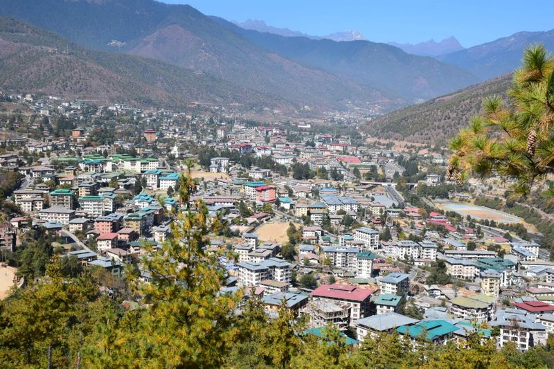
Thimphu, Bhutan’s capital, sits about an hour from Paro. While it’s the largest city, it maintains a manageable scale.
The Buddha Dordenma statue towers over the valley, a massive golden figure visible from miles away. Inside, the statue contains thousands of smaller Buddha figures, creating a stunning visual effect.
If your itinerary extends beyond Paro, Punakha Dzong deserves mention. Located at the confluence of two rivers, it’s often called Bhutan’s most beautiful dzong, with a dramatic setting that seems designed for postcards.
The drive from Paro takes several hours but passes through stunning scenery. These day trips let visitors experience Bhutan’s variety, from high mountain passes to valley fortresses, all accessible from Paro’s challenging but rewarding airport.


