Michigan’s Blue Water area is home to a trail that turns a simple walk or bike ride into something much bigger. Stretching nearly 54 miles through St. Clair County, this paved route follows the St. Clair River, Lake Huron, and Lake St. Clair, connecting waterfront parks, small towns, beaches, and historic lighthouses along the way.
What makes the trail stand out is how much variety it packs into a single route. One stretch brings you alongside massive freighters moving through the Great Lakes system, while another winds past marinas, riverfront views, and quiet shoreline parks.
The trail continues to expand each year, giving cyclists, walkers, and weekend travelers even more reasons to come back and explore another section.
Where the Trail Begins: Address, Location, and First Impressions

The official trailhead most visitors use sits along Thomas Edison Pkwy, Port Huron, MI 48060, right at the edge of the St. Clair River where the water practically glitters on a clear day. Port Huron is the anchor community of the Bridge to Bay Trail, and it is easy to see why this spot was chosen as the heart of the system.
The paved path here is smooth and wide, welcoming joggers, cyclists, dog walkers, and families with strollers without anyone feeling crowded. Benches are positioned at thoughtful intervals so you can pause, breathe in the river air, and watch an enormous freighter drift silently past.
The trail is open 24 hours a day, every day of the week, which means early risers can catch a misty sunrise over the river before the crowds arrive. That first morning view from this spot is the kind of thing that sets the tone for the whole experience ahead.
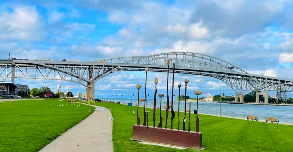
The Blue Water River Walk and Its Show-Stopping Bridge Views

Few trail segments in the entire Midwest can compete with the Blue Water River Walk in Port Huron for sheer visual drama. The Blue Water Bridge, actually a pair of international bridges connecting Port Huron to Sarnia, Ontario, Canada, towers overhead in a way that makes you feel genuinely small in the best possible sense.
The bridge lights up at night in its signature blue glow, turning the entire riverfront into something that looks almost too scenic to be real. Locals have been coming here for generations specifically to watch the freighters pass under those spans, and the tradition shows no signs of slowing down.
From certain angles along the walk, you can see both the American and Canadian shores at once, with the powerful current of the St. Clair River rushing between them. The combination of engineering scale and natural beauty packed into one short stretch of trail is genuinely hard to match anywhere else in the region.
54 Miles of Shoreline: Understanding the Full Scope of This Trail System

Most people arrive at the Port Huron section and assume they have seen the whole trail, but the Bridge to Bay Trail is actually a nearly complete 54-mile paved pathway system stretching across St. Clair County, Michigan. That number is not an estimate; it reflects years of coordinated planning and construction across multiple communities.
The trail is made up of boardwalks, riverwalks, rail trails, and dedicated bike paths, which means the surface and scenery change as you travel. Some sections feel like a classic riverside promenade, while others cut through quieter neighborhoods or pass alongside state and local parks.
Connected communities along the route include Algonac, Marine City, Marysville, St. Clair, and Port Huron, each adding its own personality to the overall experience. Thinking of the trail as a single destination undersells it; it is more accurately described as an entire region made accessible on foot or by bike, one scenic mile at a time.
Watching the Great Lakes Freighters Roll Through

One of the most unexpectedly thrilling things about the Port Huron section of this trail is how close the freighters pass. These are enormous vessels, some stretching over 700 feet long, and they navigate the St. Clair River with a precision that is mesmerizing to watch from the riverbank.
The water here runs so clear and intensely blue that you can actually see the rocky bottom in the shallower sections near the walk. During sturgeon spawning season, scuba divers enter the water right next to the walkway to observe the fish nesting along that rocky riverbed, which adds an entirely unexpected layer of wildlife watching to a simple trail visit.
Ship enthusiasts sometimes spend entire afternoons here with binoculars and cameras, tracking vessels moving between Lake Huron and Lake St. Clair. There are historical markers along the walk that explain the maritime heritage of the region, so even casual visitors leave knowing considerably more about Great Lakes shipping than when they arrived.
The Trail at Night: A Completely Different Kind of Beautiful

Visiting the Blue Water River Walk after dark is a genuinely different experience from the daytime version, and not in a subtle way. The Blue Water Bridge switches on its signature blue lighting at night, casting a cool glow across the river that reflects off the water in long, rippling streaks.
The freighters do not stop moving when the sun goes down, and there is something almost cinematic about watching a massive illuminated vessel glide past in the dark while the bridge lights frame the scene overhead. The power of the current becomes more audible at night, and the whole atmosphere shifts to something quieter and more contemplative.
Pinegrove Park sits just across from this section of the trail, adding to the ambient glow and activity level even during evening hours. Families, couples, and solo visitors all tend to linger longer at night than they planned, which is probably the clearest sign that the place earns its reputation after sunset just as much as before it.
How the Trail Has Grown: Expansion Efforts and Recent Milestones

Since 2018, significant effort has gone into closing the gaps in the Bridge to Bay Trail across seven communities, with plans to add approximately 18 miles of new routes to the existing system. That kind of coordinated regional commitment to trail infrastructure is not common, and it reflects how seriously St. Clair County takes outdoor recreation.
A notable recent milestone is the one-mile Clinton Avenue pathway in St. Clair, completed in spring 2024, which improved connectivity to that community’s downtown area. Funding secured in 2020 was also directed toward rehabilitating and reconstructing over 2.5 miles of existing trail segments that had deteriorated over time.
A project planned for 2025 targets 8.3 miles of gaps in rural areas including Burtchville, Fort Gratiot, and Cottrellville Townships, which will push the trail closer to its long-term goal of becoming one fully continuous 54-mile route. Every new section that opens adds another reason to return and explore a stretch you have not yet covered.
Economic Ripple Effects Along the Waterfront

A trail this long does not just move people through a landscape; it moves money through a region. Over the past decade, an estimated $180 million has been invested in 60 public and private projects along the Bridge to Bay Trail corridor, covering restaurants, entertainment venues, housing, hotels, and retail establishments.
That figure reflects something that urban planners often talk about but rarely get to demonstrate so clearly: a well-designed trail system genuinely anchors economic activity. Businesses along the route benefit from steady foot traffic and cycling visitors who stop to eat, shop, and explore.
The trail is officially recognized for its role in fostering recreation, social interaction, and economic prosperity across the region, which is a formal way of saying that it makes the communities along it more vibrant and more livable. Freighters restaurant near the Port Huron section is a local favorite, and the kind of spot that trail visitors naturally gravitate toward after a long walk with a view.
What to Expect on the Trail Surface and Accessibility

The Port Huron section of the Bridge to Bay Trail offers a smooth, well-maintained paved surface that handles foot traffic, cycling, and even rollerblading without complaint. The path is wide enough that passing other users never feels awkward, and the benches placed along the route make it genuinely easy to set your own pace.
Not every section of the full 54-mile system is equally polished, and it is worth noting that some segments in communities like Marine City have received criticism for uneven surfaces that make cycling uncomfortable. The trail is a work in progress across its full length, and conditions vary depending on how recently a given segment was rehabilitated.
For visitors focused specifically on the Port Huron riverfront area, the experience is consistently pleasant and accessible. The trail is open around the clock with no admission fee, making it one of the most low-barrier outdoor experiences in all of Michigan, and the flat terrain keeps it friendly for a wide range of fitness levels.
Parks, Landmarks, and Points of Interest Along the Way

The Bridge to Bay Trail is not just a path between two points; it is a thread connecting an impressive collection of landmarks, parks, and cultural sites across St. Clair County. Along and near the route, visitors encounter lighthouses, museums, beaches, state parks, and commercial districts that each add a distinct layer to the overall experience.
The Port Huron section in particular sits close to several points of interest that reward a slower pace. Historical markers along the Blue Water River Walk explain the region’s maritime past, including references to ship wrecks and the long tradition of Great Lakes navigation.
Pinegrove Park is directly across from the main riverfront section, and the big red heart sculpture near the waterfront has become a popular photo stop for families and visitors. There is enough to explore in and around the Port Huron trailhead alone to fill a full day, which makes it a practical base for anyone visiting the area for the first time.
Wildlife, Water Clarity, and Nature Surprises

The St. Clair River water that runs alongside the Port Huron section of the trail is remarkably clear, and on a calm day the rocky riverbed is visible from the walkway above. That visual clarity is part of why the Blue Water name stuck; it is not marketing language, it is just what the water actually looks like.
During sturgeon spawning season, scuba divers regularly enter the river right next to the walkway to observe the fish nesting behavior along the rocky bottom, which is the kind of wildlife spectacle you would not expect to encounter on a casual morning walk. The area is also known for good fishing, and local anglers line the riverbank with rods at various points along the trail.
Birds, river wildlife, and the occasional dramatic weather front rolling in off Lake Huron all add to the sense that this trail exists in genuine dialogue with the natural world around it, rather than just passing through it on the way somewhere else.
Best Times to Visit and Tips for Planning Your Trip

Early morning visits to the Port Huron section of the trail consistently deliver the most peaceful experience. The trail is open 24 hours a day, and arriving before the dog walkers, runners, and families with strollers all converge means you get the views largely to yourself, with the river mist still hanging low over the water.
Weekday mornings are especially calm compared to weekend afternoons, when the Blue Water River Walk draws steady crowds of locals and tourists alike. Summer is the busiest season overall, but the trail is genuinely enjoyable in spring and fall when the light on the water is softer and the freighter traffic remains active.
Parking near the Thomas Edison Pkwy trailhead is available and reasonably easy to find outside of peak summer weekends. Bringing a bike significantly expands how much of the trail system you can cover in a single visit, and the flat terrain makes even a long ride feel manageable for most fitness levels.
The Long-Term Vision: A Fully Connected 54-Mile Route

The ultimate goal for the Bridge to Bay Trail is to create one fully continuous 54-mile route connecting every community along the St. Clair River, Lake Huron, and Lake St. Clair shoreline without a single gap. That vision is closer to reality now than it has ever been, with each new construction project closing another stretch of missing trail.
When the route is finally complete, it will represent one of the most ambitious trail projects in Michigan history, linking neighborhoods, schools, parks, government centers, museums, and commercial districts into a single navigable corridor accessible to anyone on foot or by bike.
The progress made since 2018 shows that the communities involved are genuinely committed to seeing the full vision realized, not just in Port Huron but across every township and town in the system. For trail enthusiasts who like to follow a project from ambition to completion, this one is worth watching closely, because the final product is going to be something truly worth traveling to experience.


