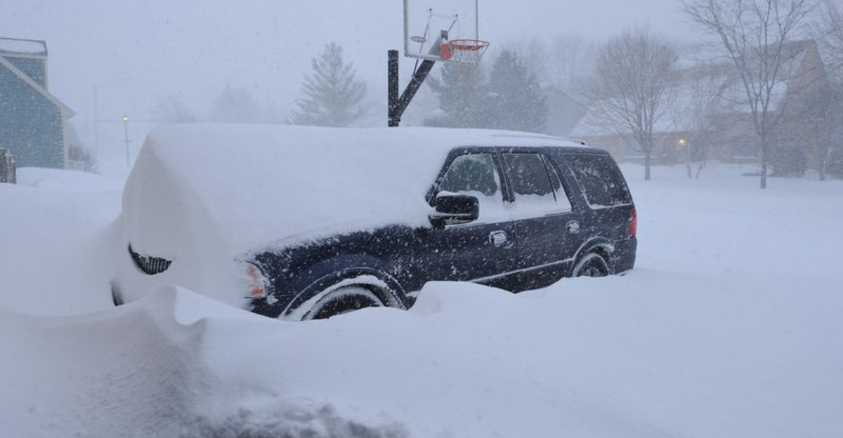
Snow is moving into Indianapolis today as a sprawling cross-country winter storm sweeps through the Midwest. You can expect changing conditions by the hour, from steady flakes to bursts of heavier snow that quickly coat roads. With temperatures sliding and winds biting, the setup is primed for slick travel and low visibility. Keep reading to know what to expect, how much could fall, and how to stay safe on the roads.
The National Weather Service has issued a Winter Weather Advisory and a Winter Storm Warning for parts of central Indiana, including Indianapolis. You will notice these alerts differ in severity, but both point to impactful snow and hazardous travel. A Warning signals higher confidence in heavier snow bands, while an Advisory still means slick conditions and reduced visibility.
Through this afternoon and evening, snow may intensify as colder air deepens and the storm strengthens. Expect quick changes: a lighter flurry can flip to fat, heavy flakes within minutes. Crews will be out, but snowfall rates could briefly outpace treatment and plowing, especially on secondary roads and bridges.
If you must travel, check the latest statements and radar updates before heading out. Alerts can shift as the storm pivots, so staying plugged in helps you avoid surprises. Keep notifications on for updates about extended durations, upgraded warnings, or localized heavy bursts near the main deformation band.

Snow is likely from this morning through tonight, with the steadiest burst arriving as the storm’s core slides east. Expect totals around 3 to 5 inches across the metro, with localized higher spots where heavier bands stall. You might notice quick half-inch to one-inch-per-hour rates during the most intense passes.
Colder air filtering in will help snow stick to untreated surfaces, even during daylight. Side streets, sidewalks, and parking lots will turn slick first, then larger roads as bursts overwhelm salt and plows. Visibility drops fast under the heavier bands, so keep extra distance and lights on.
By late evening, the broader shield eases, but flurries may linger into early morning. Small shifts in track could nudge totals up or down near the city’s north and east sides. Plan for shoveling in waves, clearing lighter layers before refreeze locks everything in place.

Temperatures will hover near or below freezing today, so fresh snow bonds quickly to pavement and untreated sidewalks. A northwest wind around 9 to 10 mph, with occasional higher gusts, adds a persistent bite and light drifting in open areas. You will feel the chill sink in as the afternoon progresses and colder air deepens.
Tonight, readings tumble well below freezing, and wind chills could dip to near minus 15 degrees in the coldest late night hours. That kind of cold steals heat fast from exposed skin, so gloves, a hat, and layers matter. If you are shoveling, take breaks and stay hydrated despite the cold air.
Inside vehicles, cabin warmth can fool you into underdressing for quick errands. Keep an extra coat, blanket, and hand warmers handy in case delays happen. Expect refreeze on any slush by evening, creating black ice on bridges, ramps, and shaded stretches.
Plan extra time, reduce speeds, and leave generous space to brake smoothly on slick pavement. Accelerate gently, avoid sudden lane changes, and use headlights whenever flakes are flying. Bridges and overpasses freeze first, so ease off the gas as you approach ramps and elevated spans.
Keep an emergency kit: scraper, small shovel, traction material, flashlight, power bank, blanket, water, and snacks. Top off washer fluid and fuel to prevent surprises if traffic slows behind plows. If you skid, steer where you want to go and avoid slamming the brakes to keep traction.
During heavier bursts, consider delaying trips until crews make a pass and visibility improves. Check INDOT cameras and NWS radar before leaving so you can time around the main band. When you get home, clear steps and walkways promptly to prevent refreeze into a hard, slick glaze.


