Tennessee has no shortage of waterfalls, but there is exactly one that pulls off a geological magic trick: it pours out of a cave, drops 110 feet, and then disappears straight into another cave at the bottom. No river continues downstream.
No creek winds away through the woods. The water just vanishes.
That alone would be enough to make this spot worth the trip, but it stacks on top of that a rugged trail system, multiple waterfalls, ancient caves, sweeping overlooks, and backcountry campsites spread across more than 1,000 acres of protected Tennessee wilderness. The hike to get there is no casual stroll, but every challenging step of the roughly 8 to 9 mile round trip pays off in a way that is hard to put into words.
Keep reading, and you will see exactly why this place earns its reputation.
The Geological Trick That Makes This Waterfall Unique

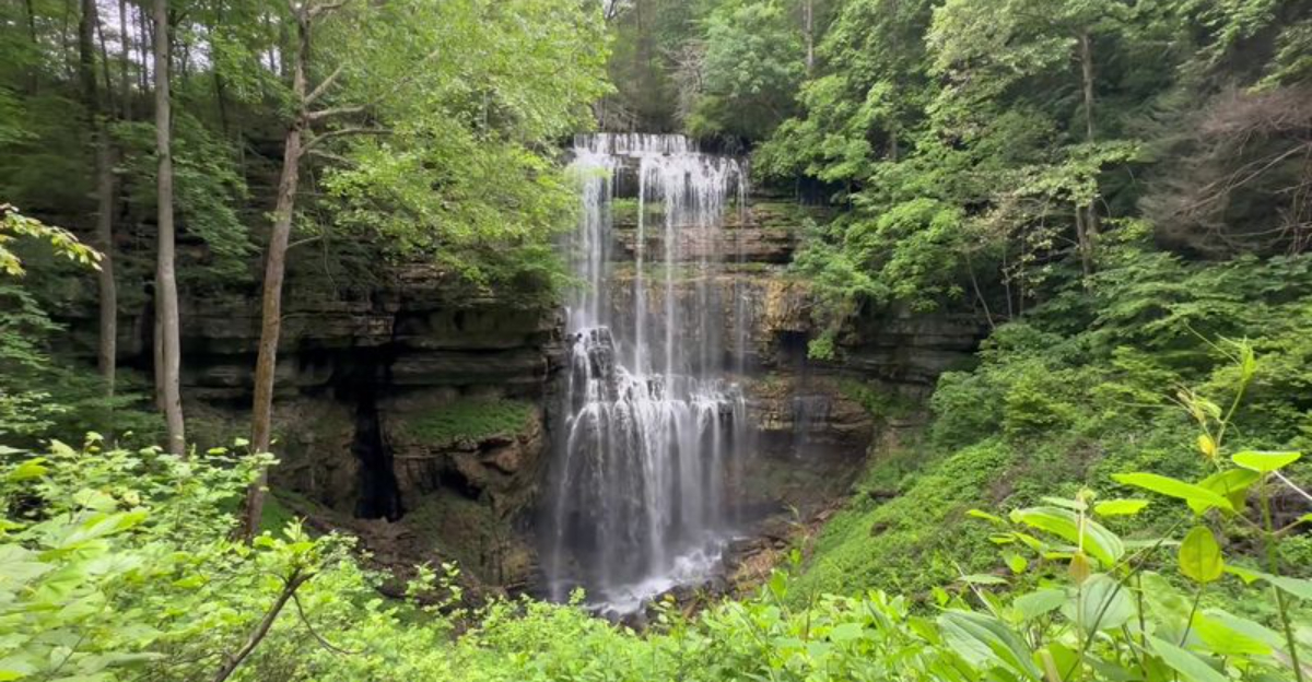
Most waterfalls follow a simple formula: water runs downhill, drops over a ledge, and continues on its way. Virgin Falls rewrites that formula entirely.
The stream that feeds it emerges directly from a cave in the bluff wall, free-falls 110 feet, and then drains into a second cave at the base of the drop, disappearing completely underground.
This phenomenon is the result of karst geology, a landscape shaped by soluble limestone that dissolves over time to create caves, sinkholes, and underground drainage systems. The water feeding Virgin Falls travels through an extensive network of subterranean passages before it ever sees daylight.
That underground origin is also why the waterfall behaves differently depending on the season. After heavy rainfall, the volume surging from the cave entrance is dramatically higher than during dry summer months.
Visiting after a good rain almost always rewards hikers with a more powerful display, making weather research before the trip a genuinely useful strategy.
How Strenuous Is the Hike, Really

The trail to Virgin Falls is listed at roughly 4 to 4.5 miles one way, putting the round trip somewhere between 8 and 9 miles total, though some hikers report the actual distance feels considerably longer once milepost markers are compared along the route. Plan for a full day regardless of what the signage says.
The hike in trends mostly downhill, which sounds like good news until the return trip begins. That same elevation loss becomes a sustained uphill climb on the way back, and it catches a surprising number of people off guard.
The section near Laurel Falls, around the 2.5 mile mark, drops into a valley that requires a tough climb to exit.
Trail conditions add to the challenge: expect rocks, exposed tree roots, mud after rain, and stretches that get slippery without warning. Solid hiking boots are not optional here.
Starting early in the morning, ideally by 8 AM when the park opens, gives enough buffer to explore without rushing the return.
What to Pack Before You Head Down That Trail

Water is the most critical item on the packing list for this hike. The round trip covers at least 8 miles of demanding terrain with no water sources along the way that are safe to drink without treatment.
Most hikers recommend carrying more than they think they will need, particularly in warmer months when the trail heats up quickly.
Snacks with real caloric value, such as granola bars or trail mix, help maintain energy through the long return climb. Bug spray earns its place in the pack too: gnats and horseflies are active along the trail, especially in summer, and they are persistent enough to ruin an otherwise great day.
Clothing choices matter as well. Light, breathable layers work better than heavy cotton, and reaching the falls almost always involves getting wet, so a change of dry clothes stashed in the car for the drive home is a practical touch that many hikers wish they had thought of sooner.
The Waterfalls You Pass Before the Main Event

Virgin Falls gets all the headlines, but the trail leading to it does not make hikers wait until the end for something worth stopping to see. Several smaller waterfalls appear along the route, each one offering a natural rest point and a reason to slow down rather than push straight through to the main destination.
Sheep Cave Falls is one of the more notable stops along the way, and it has fooled more than one hiker into thinking they had already reached Virgin Falls. The resemblance is real, but the scale and the cave-to-cave drama of the main falls is in a different category entirely.
Following the loop rather than backtracking on the same path helps ensure nothing gets missed.
The Welch Overlook, reached via a short side trail, adds another dimension to the hike with wide views across the gorge. Many hikers find that side trail more rewarding than the overlook itself, which says a lot about the overall quality of the terrain throughout this natural area.
Sheep Cave and the Underground World Below the Trail

Beneath the trails and ridgelines of this natural area runs an entirely different world. Sheep Cave is one of the most visited underground features in the park, large enough that it draws attention from hikers who spot its entrance during the loop.
The cave sits near enough to the main trail that most people can work it into their route without significant extra distance.
There is an important rule to know before getting curious: entering the caves is not permitted. The restriction exists to protect the bat populations inside from white nose syndrome, a fungal disease that has devastated bat colonies across the eastern United States.
The caves are posted with clear signage, and the rule applies to all caves within the natural area.
Even from the outside, the cave entrances are worth pausing at. The size of the openings, the cool air that rolls out of them, and the knowledge that the water flowing through Virgin Falls travels through passages like these underground makes the whole system feel connected in a way that a simple waterfall never could.
Camping in the Backcountry: What to Expect

Spending a night inside the natural area turns the experience from a day hike into something closer to a full wilderness trip. Primitive campsites are scattered throughout the backcountry, and they require advance registration before arrival.
Walk-up camping without a reservation is not an option here.
The sites themselves are well-placed within the landscape, offering genuine seclusion rather than the clustered feel of a developed campground. Hikers who camp in say the return hike the next morning, with fresh legs and a cooler trail, is a completely different experience from fighting the uphill climb at the end of a long day.
Leave no trace principles apply strictly throughout the natural area. That means packing out every piece of trash, using designated sites only, and following proper waste disposal practices on the trail.
The area has maintained its pristine condition because the people who visit it consistently treat it with respect, and that track record is worth protecting on every future visit.
Wildlife and Plants Along the Route

April brings one of the most visually rewarding versions of this hike, when the valley floor fills with wildflowers and the forest canopy is still open enough to let light reach the ground. The combination of a sheltered valley and rich soil creates conditions where plant diversity is noticeably higher than on the exposed ridgelines above.
Wildlife is present throughout the natural area, and some of it demands attention. Rattlesnakes and copperheads have both been spotted on this trail, particularly in warmer months when they move onto rocky sections to warm up.
Watching where feet and hands land, especially near rock outcroppings and log crossings, is a sensible habit on any Tennessee backcountry trail.
Poison ivy grows alongside most of the trail, sometimes in dense patches. Long pants and careful step placement reduce contact significantly.
Dogs are welcome on leashes, and the trail has been completed with pets by experienced owners, though sections with steep drops and slippery rocks require extra attention when managing an animal on a lead.
The Loop Option and How the Trail System Works

The trail to Virgin Falls is not strictly an out-and-back route. Near the falls, a signed junction offers two options for the final approach, each covering a slightly different distance but meeting at the same destination.
Taking one direction in and the other out forms a loop that ensures hikers catch every waterfall and feature in the area rather than retracing the same ground twice.
Beyond the main Virgin Falls loop, the Scott’s Gulf State Park trail network has expanded significantly in recent years, now offering more than 30 miles of total trails with additional routes still being developed. The Hemlock Springs trail provides an alternative return path that some hikers prefer for its scenery and slightly different terrain profile.
Caney Fork River is accessible from within the trail system for those with enough energy to extend the day. A rope swing near the river has become a popular stop for hikers who arrive during warmer months and want to cool off before the climb back to the trailhead.
Distance and time should be calculated carefully before committing to that extension.
Best Times of Year to Make the Trip

No single season owns this trail, but each one offers a different version of the experience. Spring delivers wildflowers in the valley and higher water volume at all the falls, making April a particularly popular month.
The waterfall runs strongest after periods of rainfall, so checking the forecast before heading out is a practical move year-round.
Summer brings full green canopy and warm temperatures, which makes the trail shady but the hike physically harder in the heat. Starting as early as possible when the park opens at 8 AM makes a real difference in comfort level during July and August.
Fall turns the ridgelines into a display of color that rivals any in the region.
Winter sees fewer hikers, which means quieter trails and a more solitary experience for those willing to layer up. Ice and frost can make already slippery sections genuinely hazardous in December and January, so traction devices on boots are worth considering for cold-weather visits when overnight temperatures have been low.
Navigating There Without Getting Lost Before You Start

One of the most consistent pieces of advice from people who have made this trip is to ignore standard GPS navigation when it comes to the final approach. Several mapping apps route drivers to incorrect locations, leaving them on dead-end roads far from the actual trailhead.
The correct destination to search is Virgin Falls Trailhead Parking, not just the park name or address alone.
The road leading to the trailhead includes several miles of unpaved surface. After rain, that section can become soft and rutted, so arriving with a vehicle that has reasonable ground clearance is worthwhile.
The nearest paved services are back in Sparta, which is the logical place to top off the gas tank and grab any last-minute supplies.
Once at the trailhead, a park officer stationed there during daytime hours can provide paper maps and answer questions about current trail conditions. That resource is more useful than it might sound, particularly when water levels or recent storm damage have changed what is accessible on a given day.
Where the Trail Begins: Address, Access, and Arrival

The trailhead for Virgin Falls sits at 2080 Scotts Gulf Rd, Sparta, TN 38583, tucked inside the Scott’s Gulf corridor of White County in the Upper Cumberland region of Tennessee. Getting there requires driving several miles of unpaved road, so a vehicle with decent clearance helps on rainy days when the gravel gets soft.
A staffed station at the trailhead hands out trail maps and answers questions during operating hours, which run from 8 AM to 5 PM every day of the week. Parking is limited in the main lot, though roadside spots along the entrance road absorb the overflow on busy weekends.
Worth noting before you arrive: there are no water fountains or sinks at the trailhead. Portable restrooms are available, but the nearest full facilities are back in the town of Sparta.
Pack everything in before the gate opens, and plan your return before 5 PM closes things down for the day.


