There is a river in Middle Tennessee that does not meander quietly through the landscape. The Falling Water River earns its name the hard way, dropping more than 250 feet through a deep limestone gorge and creating four separate waterfalls along the way.
All four of those waterfalls sit inside a single state park near Sparta, Tennessee, and the whole sequence is accessible on a trail that most people can finish in under two hours. This is one of those rare places where the natural geography does something genuinely dramatic, and the park built around it makes the whole experience surprisingly easy to access.
The River That Built This Whole Place

The Falling Water River is the reason this park exists at all. As the river moves through the area, it crosses a series of dramatic elevation drops carved into the underlying limestone bedrock, and each of those drops produces a waterfall.
The combined drop across all four waterfalls exceeds 250 feet, which is a significant amount of vertical movement for a single river over a relatively short distance. The limestone gorge the river carved over thousands of years is both the trail corridor and the main attraction.
Because the river is rain-dependent, the volume of water flowing through at any given time changes considerably with the seasons. Spring rains and winter thaws tend to push the most water through the gorge, creating the most dramatic waterfall displays.
Summer visits can be rewarding for the greenery and wildlife, but water levels are often noticeably lower during dry stretches. The river essentially sets the terms for every visit.
Little Falls: The First Drop on the Trail

Little Falls is the first waterfall hikers encounter after heading down the River Trail from the trailhead. At roughly 20 feet tall, it is the smallest of the four waterfalls in the park, but that does not mean it is forgettable.
The setting around Little Falls is densely wooded, and the creek-level perspective from the trail gives a close-up view of the water moving over the rock face. For families with younger children or people who prefer a shorter outing, Little Falls is close enough to the trailhead to be worth the walk on its own.
Photographers tend to appreciate this waterfall for its approachable scale, since the entire drop fits neatly into a frame without requiring any special gear or wide-angle lens. The rocky streambed below the falls is also a popular spot to pause before continuing down the trail toward the larger drops ahead.
It sets the tone for what the rest of the hike delivers.
Middle Falls: The One That Surprises People

Middle Falls stands about 30 feet tall and sits far enough downstream from Little Falls that the hike between them builds a bit of anticipation. A side trail branches off the main River Trail and leads directly to a viewing area in front of the falls, making it easy to stop without losing your place on the main route.
The flat, easy approach to Middle Falls is one of the more accessible sections of the entire trail system. People who are not up for the steeper terrain further along can reach this waterfall without dealing with significant elevation changes or difficult footing, which makes it a reliable option for a range of fitness levels.
Middle Falls has a wider curtain of water than Little Falls, and the rock formation behind it creates an interesting backdrop that changes in appearance depending on the light and the season. After a strong rain, the volume of water here increases noticeably, and the whole scene takes on a different character compared to a dry summer day.
Upper Falls: The 80-Foot Powerhouse

Upper Falls is the second-largest waterfall in the park, dropping approximately 80 feet into the gorge below. The scale of it is noticeably different from the two smaller falls upstream, and the surrounding limestone walls amplify the effect by creating a natural enclosure around the plunge pool.
The trail to Upper Falls involves some steeper sections and uneven terrain, including rock outcroppings and tree roots that require careful footing. The park does provide railings and marked pathways through the trickier sections, but solid footwear is genuinely important here rather than just a polite suggestion.
There is an overlook position near Upper Falls that provides a strong vantage point for photography without requiring anyone to get dangerously close to the edge. On sunny days, the angle of the light through the gorge can produce a rainbow effect in the mist near the base of the falls, which shows up well in photos taken from the designated viewing areas.
Upper Falls alone justifies the effort of the hike.
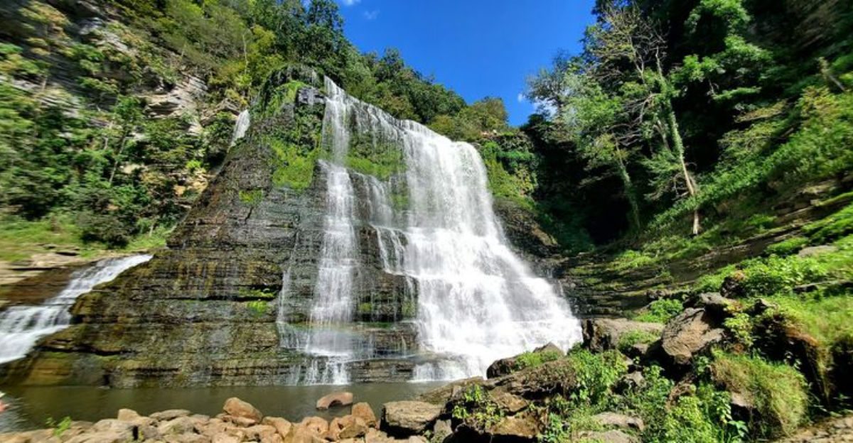
Burgess Falls: The 136-Foot Main Event

The main Burgess Falls is a 136-foot block waterfall, which means the water drops in a wide, powerful sheet rather than a narrow ribbon. It crashes into a large plunge pool at the base of the gorge, and the overlook platform at the end of the River Trail positions hikers almost directly above it.
The platform itself is well-constructed and offers an unobstructed view straight down into the falls and the pool below. On windy days, mist from the falls reaches the overlook, which gives the spot a distinctly different atmosphere compared to a calm day.
Photos from this platform tend to capture the full scale of the drop in a way that most trail-side vantage points cannot.
Swimming is prohibited anywhere in the gorge due to dangerous currents and the undercut rock formations near the base of the falls. The prohibition is clearly marked throughout the park.
The overlook platform is the correct and safe way to experience the main falls up close, and it delivers a view that most people find genuinely hard to leave.
The River Trail: What the Hike Actually Looks Like

The River Trail is the primary hiking route through the park and covers approximately 1.5 miles as a round trip. It connects all four waterfalls in sequence and is rated moderate to strenuous due to a combination of steep staircases, uneven rock surfaces, and significant elevation changes near the lower end of the gorge.
The trail is well-marked with signage at key junctions, and railings are installed at the more exposed sections. Most reasonably fit adults can complete the full trail in about 30 to 45 minutes each way, though many people stop longer at each waterfall, stretching the total outing to well over an hour.
The park also offers a paved access path from the parking area that leads more directly to the main Burgess Falls overlook, providing a shorter and less demanding alternative for those who want to see the signature waterfall without tackling the full trail. Both routes are worth knowing about before arrival, depending on who is in the group.
Trail Difficulty and Who Should Know Before Going

The River Trail is not a casual stroll, and the park does not pretend otherwise. The steep staircases and rocky sections near the lower gorge require steady footing and a reasonable level of physical conditioning.
Anyone with significant knee, ankle, or hip issues should think carefully about how far they want to go before starting.
That said, the park offers more accessible options for people who cannot manage the full trail. The paved path to the Burgess Falls overlook and the flat approach to Middle Falls both provide meaningful waterfall views without demanding the same level of effort as the full River Trail descent.
Children who are old enough to handle stairs independently and follow trail safety rules can manage the full hike with adult supervision. The park recommends proper footwear for all visitors, and that advice applies especially to the lower sections of the River Trail where wet rocks and uneven terrain are constant factors.
Dress shoes and sandals are a poor choice here, regardless of how short the trail looks on a map.
Best Time of Year to Visit for Maximum Waterfall Impact

The Falling Water River responds directly to rainfall, which means the waterfalls at Burgess Falls State Park are not the same experience year-round. Spring is widely considered the best season for waterfall volume, as snowmelt and seasonal rains push significant water through the gorge and all four falls run at or near full capacity.
Winter visits after a thaw can also produce impressive water flow, and the bare trees during that season open up sightlines through the gorge that summer foliage blocks. Fall brings color to the surrounding forest and cooler temperatures on the trail, making it a popular time for photography even if water levels are beginning to drop.
Summer is the most popular season for visitor numbers, but it is also the most likely period for reduced water flow during dry stretches. The greenery is at its peak and the forest canopy provides shade on the trail, which helps on warm days.
Visiting on a weekday during any season dramatically reduces the parking situation compared to a busy weekend.
Wildlife, Fishing, and Other Reasons to Linger

The park offers more than just the waterfall sequence. The Falling Water River below the falls supports populations of smallmouth bass and rock bass, making it a functional fishing destination for anglers who want to combine a hike with time on the water.
Fishing is permitted in designated areas of the river near the park.
Birdwatchers have reason to keep their eyes on the gorge walls and the sky above the park. Great blue herons are a regular presence along the river, and peregrine falcons have been spotted in the area as well.
The mix of open water, rocky cliff faces, and dense forest creates habitat that draws a solid variety of bird species throughout the year.
Near the parking area, the park maintains a butterfly garden and a native plant section that provides a low-key introduction to local flora before the main trail begins. It is a small feature, but it adds context to the broader ecosystem that the park sits within and gives younger visitors something concrete to look at before the hike starts.
The Full Picture: What Makes This Park Stand Out in Tennessee

Tennessee has no shortage of state parks, and travelers moving through the state on Interstate 40 will pass signs for multiple parks within a single stretch of highway. Burgess Falls earns its reputation not because it is the only option but because it delivers something genuinely rare: four waterfalls in sequence, all accessible on a single trail, all free to visit, and all located within 350 acres of protected natural landscape.
The combination of the 136-foot main falls, the dramatic limestone gorge, and the well-maintained trail system puts it in a category that few other day-use parks in the state can match. The fact that no camping is available on-site keeps the experience focused on the natural features rather than the logistics of an overnight stay.
For anyone passing through Middle Tennessee or making a deliberate trip from Cookeville, Nashville, or beyond, Burgess Falls State Park at 4000 Burgess Falls Dr, Sparta, TN 38583, represents one of the most rewarding short hikes in the entire region. The Falling Water River has been doing the hard work for thousands of years, and all visitors have to do is show up early enough to park.
Where the Park Actually Is and How to Get There

Burgess Falls State Park sits at 4000 Burgess Falls Dr, Sparta, TN 38583, positioned in both Putnam and White counties in Middle Tennessee. The park is roughly 15 miles south of Cookeville and is one of the more accessible natural attractions in the region.
Getting there is straightforward from Interstate 40. Take exit 286, then head south on TN-135 for about eight miles and follow the signs directly to the park entrance.
The drive through the surrounding countryside is pleasant, with rolling hills and farmland marking the route.
The park is open every day from 8 AM to 7 PM, and admission is completely free. Leashed dogs are welcome on the trails, which makes it a solid option for people traveling with pets.
Parking is available on-site, though it fills up quickly on weekends and holidays, so arriving early is strongly recommended to avoid a wait.


