Some ancient mysteries hide in tombs or temples, but these ones are sprawled across open ground in lines so large they barely make sense until you leave the earth behind. Scratched into deserts, hillsides, and plains, they depict animals, people, spirals, arrows, and geometric layouts with a confidence that still makes modern researchers pause and say, in effect, well, that is puzzling.
The strange part is not just their scale, but their stubborn refusal to fit neatly into one explanation: ritual routes, celestial markers, territorial signs, practical maps, and water ceremonies all appear in the debate, yet none solve every case. Ahead, you will meet twelve of the most intriguing examples, from Peru to Kazakhstan to Australia, with the facts, the best theories, and the unanswered questions that keep these giant drawings firmly planted in the category of ancient head-scratcher.
1. The Nazca Lines (Peru)
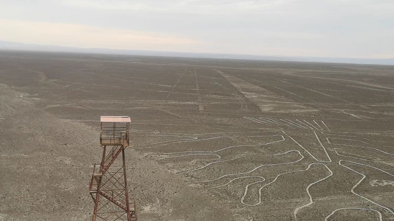
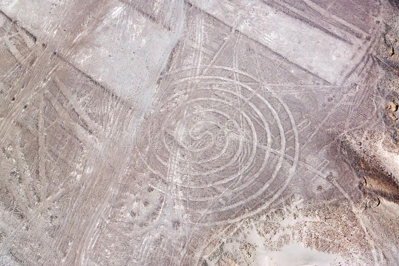
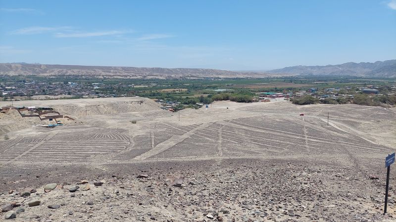
First comes the celebrity of the geoglyph world, and it earns the attention. The Nazca Lines spread across southern Peru in huge drawings of animals, plants, and crisp geometric paths, created roughly between 500 BCE and 500 CE by removing dark stones to reveal lighter ground below.
The monkey, hummingbird, spider, and condor get the most postcards, but the wider network includes hundreds of lines, trapezoids, and shapes that stretch across the pampa with startling control. Because many figures are best understood from above, people keep asking the same reasonable question: who made artwork that few people on the ground could fully appreciate?
Researchers have proposed ceremonial walking routes, astronomical alignments, and connections to water rituals in this dry region. New drone surveys and AI-assisted studies continue finding additional figures, which only adds another twist: the puzzle is bigger than earlier generations realized.
2. The Sajama Lines (Bolivia)
Now for something even more sprawling, yet far less famous. The Sajama Lines cut across Bolivia’s high plain in thousands of nearly ruler-straight tracks, forming an enormous network that covers an area far larger than Nazca.
These lines were likely created by Indigenous peoples over many centuries, with routes cleared through vegetation and soil so they remained visible across the altiplano. What makes them so striking is their precision over long distances, often running toward hills, shrines, or older sacred sites, though to modern eyes many seem to head nowhere useful at all.
That apparent nowhere is part of the mystery. Some archaeologists think the lines functioned as pilgrimage paths linking communities to ceremonial points, rather than roads in the everyday sense.
Seen together, they suggest planning on a huge scale, and they quietly challenge the idea that only the most famous geoglyphs demanded sophisticated landscape design.
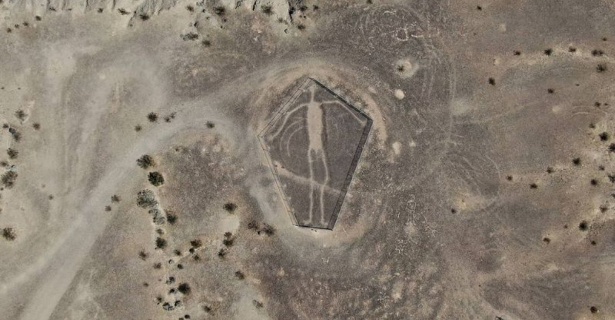
3. The Atacama Giant (Chile)
One hillside in Chile hosts a giant human figure that looks like it is still waiting for an explanation. The Atacama Giant, cut into Cerro Unitas in the Atacama Desert, measures about 390 feet tall and stands among the largest prehistoric anthropomorphic geoglyphs on Earth.
Its body is simple but deliberate, with a rectangular torso, extended limbs, and a head topped by lines or headdress-like projections. Scholars usually connect it to pre-Columbian cultures active between about 1000 and 1400 CE, and some have argued that details in the figure may relate to astronomical observations or seasonal calendars.
Others see a ceremonial image, a deity, or a marker on caravan routes crossing one of the driest regions anywhere. No single theory settles the matter.
The giant remains a superb example of how ancient people used entire hillsides as canvases, then left later generations with confidence, scale, and a giant unanswered question.
4. The Blythe Intaglios (California, USA)
California has its own oversized puzzle scratched into the desert, and it does not bother with subtlety. The Blythe Intaglios are giant ground figures in the Colorado Desert near the lower Colorado River, including human forms and animal shapes that reach impressive lengths.
They were likely made by Indigenous peoples, probably ancestors of Quechan and Mojave communities, by removing the dark top layer of stones to expose lighter soil underneath. Because the figures are easier to appreciate from nearby hills or the air, debate continues over how they were used and what audiences they were meant to reach.
Some interpretations connect them to ceremonial traditions or mythic beings remembered in oral histories. Others focus on territorial significance or gatherings linked to important social events.
Dating has been difficult, which keeps conclusions cautious. That uncertainty has become part of their appeal: they are plainly intentional, plainly meaningful, and still not fully readable to us.
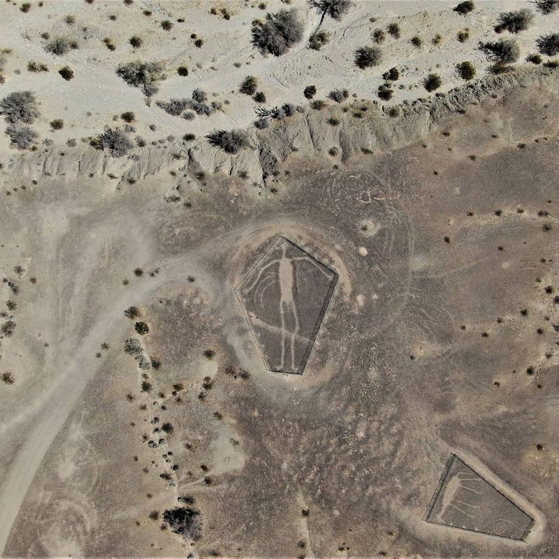
5. The Paracas Candelabra (Peru)
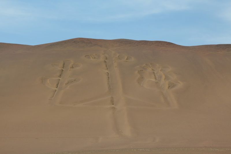
Few ancient symbols look this confident from such a distance. The Paracas Candelabra is a massive trident-like geoglyph carved into a sandy slope on the Paracas Peninsula of Peru, visible from the sea for miles.
At roughly 600 feet long, it is much simpler than the Nazca animal figures, yet its bold outline makes it unforgettable. Researchers have linked it variously to the Paracas culture, maritime navigation, ritual symbolism, or even iconography associated with staffs and sacred imagery known elsewhere in the ancient Andes.
The problem is that simplicity does not equal clarity. A seafaring marker sounds practical, but there is no solid agreement that navigation alone explains such effort.
A ceremonial emblem fits the region’s rich spiritual traditions, but that remains a theory rather than a settled answer. For now, the Candelabra keeps its secret while continuing to look like the coastline made a giant note and forgot to add the caption.
6. The Kazakh Geoglyphs (Kazakhstan)
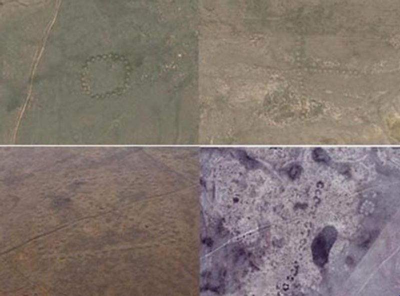
Satellite imagery gave this mystery a modern entrance, and what an entrance it was. Across northern Kazakhstan, researchers identified huge geometric earthworks shaped like squares, crosses, rings, and lines, many so large they are best grasped from above.
These features, often called the Turgai geoglyphs, were discovered in the twenty-first century and quickly sparked debate about who built them and why. Some may date back several thousand years and could be linked to steppe communities that organized labor on a scale many people did not expect in that region.
The shapes are not random scrawls. They show planning, repetition, and placement within the landscape, which suggests social or ceremonial purpose rather than casual ground marking.
Theories include ritual spaces, territorial symbols, and observational sites tied to the sky, but evidence remains incomplete. That makes them especially intriguing: they are newly noticed by science, ancient in origin, and still waiting for a consensus that refuses to arrive.
7. The Marree Man (Australia)
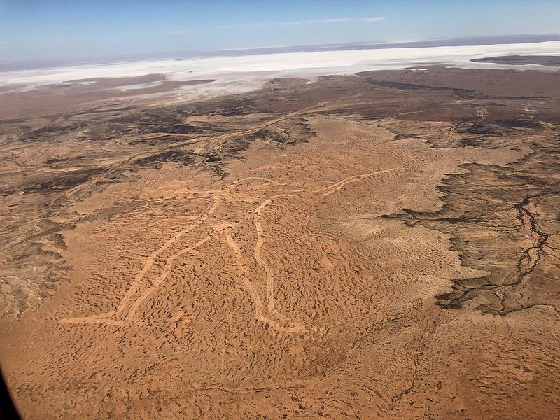
Not every giant ground figure belongs to deep antiquity, and this one proves modern times can be just as puzzling. The Marree Man appeared in the South Australian outback in 1998 as a colossal geoglyph depicting a hunter or tracker, stretching more than two miles in length.
Unlike ancient examples, its age is no mystery at all, yet the identity of its creator remains unresolved. The figure was produced with modern equipment, and anonymous faxes, press contacts, and scattered clues created a mystery that mixed prank energy with serious logistical skill.
That combination is exactly why the Marree Man keeps earning a place in conversations about unexplained lines. Someone planned it carefully, chose a remote location, and managed the work without a clear public claim.
The result is a strange crossover between land art, publicity puzzle, and cultural curiosity. It may be modern, but it taps the same big question as older geoglyphs: what motivates people to write on landscapes at gigantic scale?
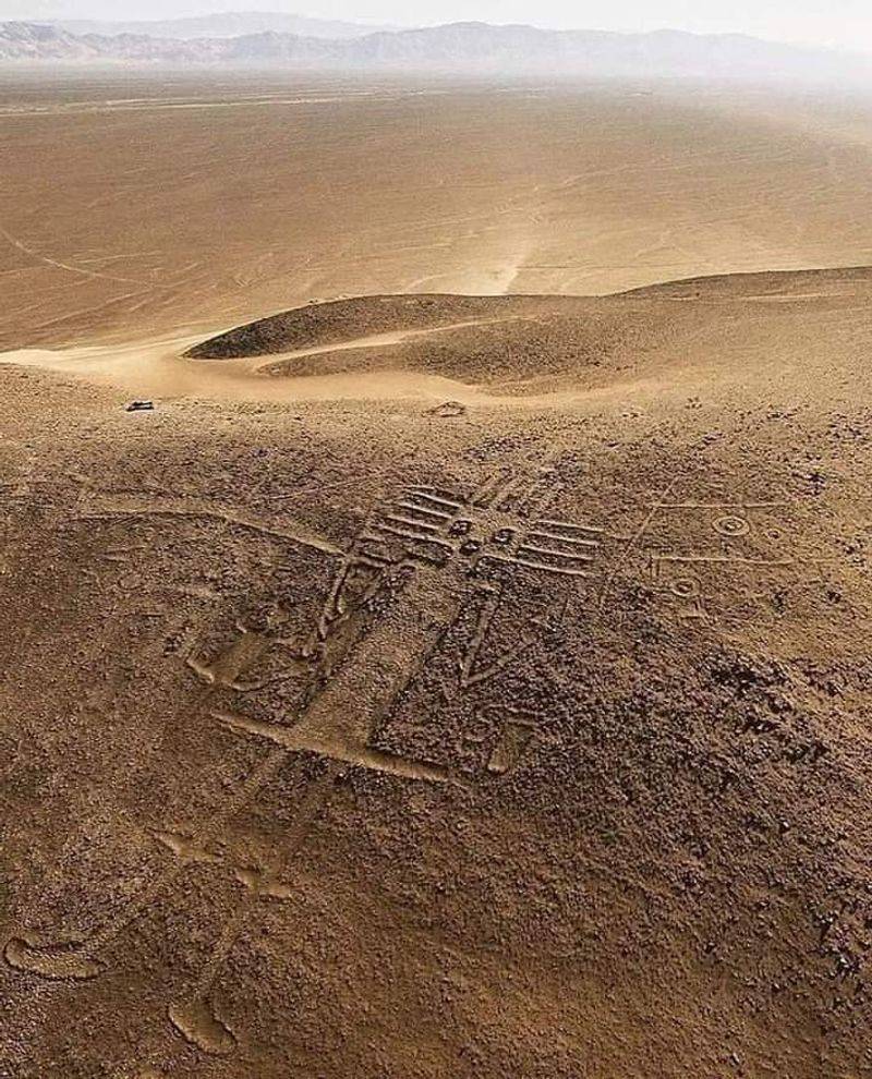
8. The Nasca Spirals and Lines Network (Peru)
Beyond the famous animal drawings lies a whole system that deserves its own spotlight. The wider Nasca network includes hundreds of straight lines, broad trapezoids, radiating forms, and spirals that spread across the Peruvian desert with a level of planning that feels almost stubbornly exact.
Some of these marks align with hills, ceremonial points, or water-related features, while others seem to ignore the explanations that would make everyone comfortable. That is why the network matters so much.
It suggests the Nazca tradition was not only about producing memorable figures, but also about organizing movement and meaning across the landscape.
Several scholars argue that certain lines were meant to be walked during ceremonies, which would make them active spaces rather than passive images. Others examine possible astronomical alignments, though not enough fit cleanly to make that a complete answer.
Spirals add another wrinkle, because they may reference wells or water symbolism. In short, the network is less one riddle than a committee of riddles.
9. The Amazon Geoglyphs (Brazil)
Rainforest was supposed to hide the story, but modern clearing revealed a very different chapter. In parts of Brazil’s Amazon, archaeologists have documented large geometric earthworks, including circles, squares, and connected enclosures that were invisible beneath dense forest for centuries.
These geoglyphs are not desert scratches but earthworks formed by ditches and embankments, often arranged with remarkable regularity. Their existence pushed researchers to reconsider older assumptions that this region was only lightly populated in the distant past, because such projects imply organized communities, planning, and repeated labor.
Purpose remains debated. Some sites may have been ceremonial gathering spaces, others could have marked territories or coordinated social events, and some may have served several roles over time.
What makes them especially compelling is the collision between old assumptions and new evidence. The Amazon was not empty background waiting for history to happen elsewhere.
These earthworks say people were shaping this landscape boldly, and we are still catching up.
10. The Chilean Desert Animal Figures
Chile’s desert keeps serving bonus mysteries long after the giant figure gets the headlines. Across the Atacama region, archaeologists have recorded numerous animal geoglyphs, including llamas, birds, and abstract forms placed on hillsides and open ground along ancient travel corridors.
Many of these figures are smaller than the most famous examples in Peru, but together they form a dense and revealing cultural landscape. Their placement often suggests links to caravan routes used for moving goods across harsh terrain, especially by communities involved in exchange networks that connected coast, desert, and highlands.
That practical context still does not fully explain the imagery. Llama caravans mattered economically, yet depicting them at scale may also have expressed identity, belief, or ritual concerns tied to travel and protection.
Some figures may have guided movement, others may have marked meaningful places, and some could have done both. The evidence is suggestive rather than final, which keeps the desert’s visual archive intriguingly open-ended.
11. The Peruvian Desert “Band of Holes” (Pisco Valley)
If most geoglyphs look like drawings, this one looks like a system no one can quite decode. The Band of Holes in Peru’s Pisco Valley stretches across a hillside in thousands of evenly spaced pits, forming long, narrow rows that run for nearly a mile.
The precision suggests careful planning, but the purpose remains unclear. Some researchers think the holes were used for storage tied to ancient trade routes, while others see a ceremonial or symbolic pattern.
What makes the site so puzzling is its lack of a clear visual message. There are no animals or shapes – just rows of holes that feel intentional, organized, and still unexplained.
12. The Uffington White Horse (England)
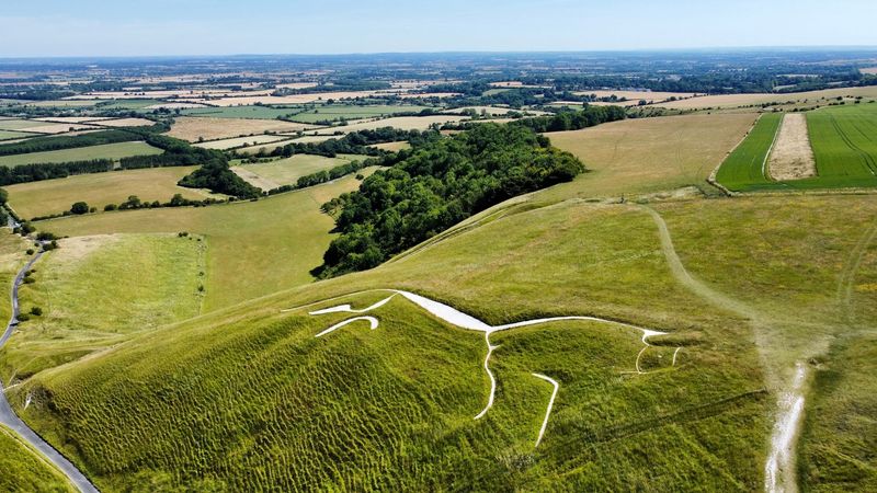
England joins the lineup with a figure that proves wet weather does not cancel mystery. The Uffington White Horse is a long, stylized horse cut into a chalk hillside in Oxfordshire, its elegant lines maintained for around three millennia through repeated community care.
Unlike many geoglyphs that disappear into obscurity, this one has remained visible because generations kept clearing vegetation and preserving the outline. Dating places it in the late Bronze Age or early Iron Age, and its design looks intentionally abstract, which suggests symbolism mattered as much as representation.
Was it a tribal emblem, a ritual image, a status marker, or a statement tied to movement, power, or belief? Scholars have proposed all of the above.
Nearby earthworks and the broader ceremonial landscape add weight to sacred interpretations, but nothing closes the case. The horse keeps running through history without moving an inch, which is efficient travel and excellent mystery management at the same time.
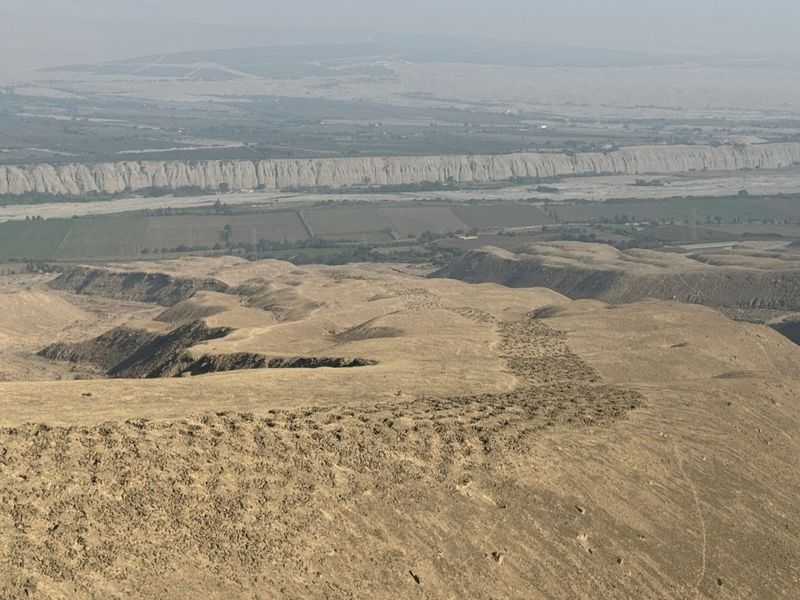
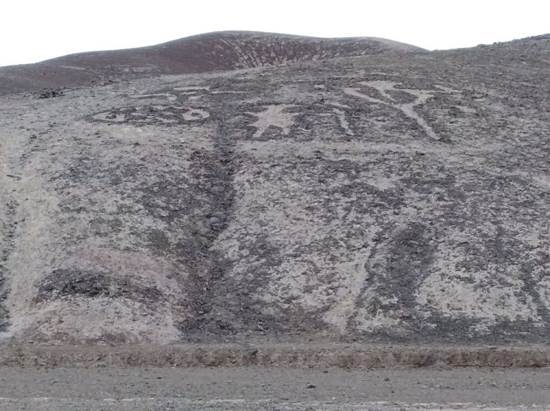
13. The Palpa Lines (Peru)
Overshadowed by nearby Nazca, the Palpa Lines offer a quieter but equally intriguing version of desert art. Spread across hills and plains, these geoglyphs include human figures, animals, and geometric shapes created by cultures closely linked to the Nazca.
Unlike Nazca’s flat designs, many Palpa figures sit on slopes, making them visible from the ground. That raises a key question: were they meant to be seen differently, or used for different purposes?
Their variety and placement suggest a broader tradition of landscape design – one that extends beyond a single famous site and remains only partly understood.
14. The Chug Chug Geoglyphs (Chile)
In Chile’s Atacama Desert, ancient figures line routes once used by traveling caravans. The Chug Chug Geoglyphs include human shapes, animals, and geometric designs formed by clearing or arranging stones across the desert floor.
Their position along trade paths suggests they may have guided or marked movement, but their scale hints at something more. Some researchers believe they held ceremonial or symbolic meaning tied to the people crossing this harsh landscape.
Like many desert markings, they are easy to miss up close – but from above, they reveal a deliberate and still mysterious design.


