Some of Pennsylvania’s most dramatic scenery is hiding in Bucks County. This park features sandstone cliffs rising as high as 200 feet above a winding creek, along with hiking trails, rock climbing routes, and overlooks that showcase one of the region’s most striking landscapes.
What makes the destination stand out is the variety packed into a single visit. Outdoor enthusiasts come for the climbing, paddling, and trails, while others are drawn by the historic bridge, the gorge views, and the area’s rich history.
With so much to explore, it is easy to see why many first-time visitors start planning their next trip before the first one is over.
Where to Find This Hidden Corner of Bucks County

Ralph Stover State Park sits at 6011 State Park Rd, Pipersville, PA 18947, tucked into a quiet stretch of Bucks County that feels worlds away from the Philadelphia suburbs just a short drive south.
The park covers 45 acres and is bisected by Tohickon Creek, which gives the whole place its character. You can reach the main day-use area from the primary entrance, or drive separately to the High Rocks section off Tory Road for cliff-top views without a long hike.
The park is open daily from 8 AM to 7 PM, and the phone number for inquiries is +1 610-982-5560. Cell reception can be spotty inside the park, so download trail maps before you leave home.
Two separate parking areas serve different parts of the park, which makes planning your visit a little more strategic than your average afternoon outing.
The Cliffs That Make Your Stomach Do a Little Flip

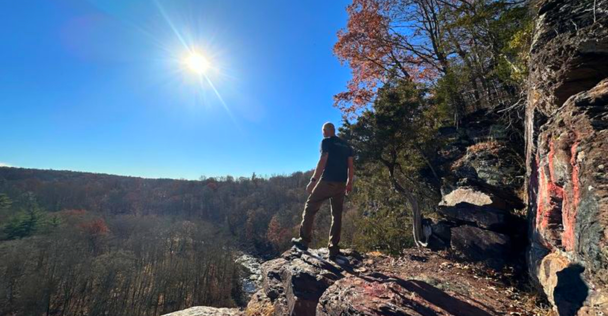
The High Rocks are the main attraction here, and the first time you see them up close, the scale is genuinely surprising. These sheer cliff faces rise anywhere from 30 to 200 feet above the Tohickon Gorge, composed of red Brunswick shale, Lockatong Formation argillite, and Triassic sandstone.
A sturdy fence runs along the most exposed sections of the trail that hugs the cliff edge, which is reassuring given the dramatic drop below. Even with that protection, standing at the rim and looking down at the creek curving through the gorge is enough to make most people grip the railing a little tighter.
Three separate trail paths run along the High Rocks area at varying distances from the edge, so you can choose your own level of exposure. The rock can be brittle in places, which is something both hikers and climbers keep in mind.
The view from the top of that horseshoe bend is the kind of image that stays with you long after you drive home.
Rock Climbing Routes That Range From Beginner to Bold

Ralph Stover is one of only three state-run rock climbing areas in all of Pennsylvania, which gives it a special status among the climbing community in the eastern part of the state. The High Rocks wall offers close to 100 routes, with some counts pushing past 160 depending on how you classify variations.
Top-roping is the dominant style here, and the walk-up approach to the anchors makes the area genuinely beginner-friendly for anyone who already understands how to set a TR anchor. The bolts and chains on the wall are well maintained, and the climbing community keeps a close eye on conditions.
The section known as Practice Face is the most worn, with holds that have softened considerably over the years, which actually makes grades feel harder than listed. Further down the wall, the rock is fresher and the routes feel more technical.
Whether you are brand new to climbing or working on more serious leads, this wall has something to offer at almost every skill level.
Tohickon Creek and the Story Behind Its Name

The name Tohickon comes from the Lenape term “To-Hick-Hanne,” which translates roughly to “Deer-Bone-Creek.” That is a name with real character, and it fits a waterway that has shaped this landscape for centuries before the park ever existed.
The creek winds through the 45-acre park and creates a natural centerpiece that ties every activity together. From the High Rocks above, you can see it curving through the gorge in a horseshoe bend that photographers love.
Down at creek level, the water moves at a gentler pace during dry seasons, shallow enough in spots for kids to wade across.
Picnic tables are scattered along the banks, and the shaded areas near the water are popular on warm weekends. The creek banks can get muddy, especially after rain, so solid footwear is a practical choice rather than an optional one.
The whole setting along the water feels like a natural pause button, and it is easy to spend more time here than you originally planned.
Whitewater Releases That Turn the Creek Into Something Else Entirely

Twice a year, the dam at Lake Nockamixon releases water into Tohickon Creek, and the transformation is dramatic. The releases typically happen in late March and early November, turning what is normally a calm creek into a Class IV whitewater experience that draws kayakers and canoeists from across the region.
On release days, the creek banks fill with spectators as much as paddlers. Watching skilled kayakers navigate the surging water from the High Rocks above is its own kind of entertainment, and the combination of fall foliage and churning whitewater in November is genuinely spectacular.
Planning your visit around a release date takes a little research, but the Pennsylvania DCNR website and local paddling clubs post schedules in advance. The creek level outside of release events is generally low and calm, so the contrast on those two weekends each year is striking.
If whitewater paddling is on your bucket list, this is one of the more accessible and scenic spots to experience it in eastern Pennsylvania.
Fishing the Creek From Bank to Bend

Tohickon Creek is a genuine fishing destination, not just a scenic backdrop. The water holds smallmouth bass, sunfish, carp, catfish, and stocked trout, which means anglers with different preferences can all find something worth casting for.
The stocked trout make the creek especially popular in spring, when Pennsylvania Fish and Boat Commission releases draw early-season fishers who sometimes have the banks nearly to themselves on quiet weekday mornings. The shallow sections near the picnic area offer easy bank access, while more serious anglers tend to work their way upstream to find deeper pools.
The creek is not a large waterway, so wading is common and often necessary to reach the better spots. Water shoes or wading boots make the experience more comfortable, and the rocky creek bed can be slippery in places.
Fishing here has a low-key, unhurried quality that suits the overall atmosphere of the park, and the combination of canopy shade and moving water keeps temperatures manageable even on warmer days.
Trails That Reward You for the Climb

The trail system at Ralph Stover covers a modest but rewarding network through deciduous forest, along the creek, and up to the cliff-top ridgeline. Color-coded markers guide the way, with yellow and orange trails being the most commonly used routes for visitors making a full loop of the park.
The yellow trail takes you through the woods and connects to the High Rocks area, while the orange trail drops down toward the creek level. Combining both in a single outing takes roughly two hours at a comfortable pace, and the elevation changes make it feel more substantial than the mileage suggests.
Some sections have a notable drop-off to one side, and the trail near the creek can be muddy after rain. Hiking boots with ankle support are a better choice than sneakers here, especially if you plan to go off the main path.
Trail signage has improved in recent years, but downloading a map from AllTrails before your visit is still the smartest move you can make.
The Historic Bridge That Holds a Continental Record

Not many state parks can claim a North American record, but Ralph Stover has one. The day-use section of the park contains the longest boxed Howe pony truss bridge on the continent, a structure that blends history with function in a way that most visitors walk right past without realizing what they are looking at.
The Howe truss design was patented in the 1840s and became a common bridge style throughout the 19th century. Finding one preserved in working condition, let alone holding a length record, is genuinely rare.
The bridge spans Tohickon Creek and serves as a crossing point for visitors moving between the lower park and the trails heading toward High Rocks.
The WPA-era stone structures scattered through the park complement the bridge and give the whole area a layered historical texture that goes deeper than most people expect from a small county park. History buffs will find more to examine here than the trail map lets on, and that is part of what makes a second visit worthwhile.
Wildlife and Natural Details Worth Slowing Down For

The park is a genuinely rich environment for wildlife observation, and you do not need to be a serious naturalist to appreciate it. The forest holds a wide range of bird species, and the creek banks attract aquatic insects, frogs, and the occasional snake skin left behind on a sun-warmed rock.
Fungi enthusiasts will find plenty to photograph along the wooded trails, especially after a wet spell in late summer or fall. The combination of deciduous forest, rocky outcrops, and a live waterway creates a variety of microhabitats that support more biodiversity than the park’s modest acreage might suggest.
Bringing a field guide or a plant identification app adds a whole extra layer to a visit that might otherwise focus entirely on the views and the climbing. Kids especially seem to connect with the creek-level wildlife, and the shallow water sections make it easy to observe aquatic life up close without any special equipment.
The park rewards slow, curious walkers just as much as it rewards the fast hikers.
Picnicking With a View That Most Parks Cannot Match

The day-use area along Tohickon Creek is set up for relaxed outdoor dining in a way that feels genuinely thoughtful. One large picnic pavilion anchors the space, and two smaller pavilions with stone fireplaces offer a more sheltered option for groups who want a fire alongside their meal.
Picnic tables are scattered throughout the creek-side area, and the tree canopy keeps the space cool even in midsummer. The sound of the creek running nearby is a constant backdrop that makes even a simple packed lunch feel like more of an occasion than it probably deserves.
The pavilions can be reserved in advance through the Pennsylvania DCNR system, which is worth doing if you are planning a group outing during a busy weekend. Portable restroom facilities are available on-site, and the overall setup is clean and well-maintained.
For families who want a low-effort outdoor experience with high scenic returns, the picnic area alone justifies the drive out to Pipersville.
The Revolutionary War History Hiding in the Hillside

The area around the park carries a layer of colonial history that most visitors never hear about. During the Revolutionary War, the caves in the hillsides near Tohickon Creek served as hiding places for the Doan family, a group of outlaws known for their loyalty to the British Crown and their skill at evading Patriot forces.
The Stover grist mill, whose remains sit at the north end of the park, operated along the creek for generations and represents the agricultural history of the region long before it became a state park. The mill ruins are easy to miss but worth seeking out if you enjoy connecting landscape to history.
Before European settlement, the Lenape people lived and traveled through this valley, and the creek name itself is a direct linguistic inheritance from that era. The park holds multiple historical layers that reward visitors who take the time to look beyond the rocks and the trails and ask what happened here before the parking lot existed.
Practical Tips That Will Make Your Visit Run Smoothly

A few practical details will save you time and frustration when you visit. The park has two separate parking areas: one at the main day-use entrance near the bridge, and one at the High Rocks section off Tory Road.
Choosing the right lot for your plans makes a real difference in how your day unfolds.
Cell reception is unreliable throughout much of the park, so downloading trail maps from AllTrails or the DCNR website before you leave is strongly recommended. The park opens at 8 AM and closes at 7 PM every day of the week, so plan your timing accordingly, especially if you want to catch golden-hour light on the cliffs.
Solid hiking shoes are a genuine necessity rather than a suggestion, given the muddy creek banks and the uneven terrain near the cliff trails. Bringing extra water, a basic first aid kit, and a physical map covers most contingencies.
The park is open year-round in terms of access, and each season brings its own distinct character to the landscape.


