
Some roads are built just to get you somewhere. But a handful of highways have become legends — stretching across mountains, coastlines, and entire continents in ways that make the drive itself unforgettable.
From the neon-lit nostalgia of Route 66 to the jaw-dropping bridges of Norway’s Atlantic Ocean Road, these routes are more than asphalt and white lines. Buckle up, because this list celebrates the most famous highways on Earth.
Route 66 – USA
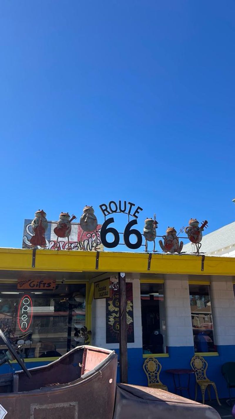
Back in 1926, a stretch of road quietly changed America forever. Route 66 — nicknamed the “Main Street of America” — runs 2,400 miles from Chicago, Illinois, all the way to Santa Monica, California.
It was one of the first highways to connect the East to the West, and it became the backbone of American road trip culture.
During the Great Depression and Dust Bowl era, thousands of families packed everything they owned and drove this highway searching for a better life. That history gives Route 66 a weight and soul that few roads can match.
Writers, musicians, and filmmakers have all celebrated it.
Today, stretches of the original road still survive, dotted with vintage diners, quirky roadside statues, and classic motor lodges frozen in time. Towns like Amarillo, Flagstaff, and Barstow each offer their own slice of Americana.
Many sections have been replaced by modern interstates, but dedicated Route 66 fans still seek out every original mile. Driving it feels less like a commute and more like flipping through the pages of American history.
Pacific Coast Highway (Highway 1) – USA
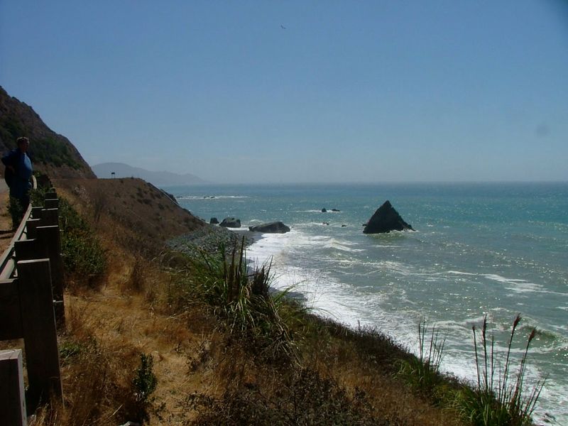
Wind down the windows, let the salt air in, and prepare for one of the most breathtaking drives on the planet. California’s Pacific Coast Highway — officially Highway 1 — hugs the rugged California coastline for roughly 655 miles, threading between towering cliffs and the crashing Pacific Ocean below.
Big Sur is the undisputed showstopper along this route. Sheer cliffs drop hundreds of feet into the sea, and on clear days the views stretch so far you start to wonder where the ocean ends and the sky begins.
Bixby Creek Bridge, one of the most photographed bridges in California, arches gracefully over a canyon here.
The highway connects major destinations like San Francisco, Carmel-by-the-Sea, and Santa Barbara, but most drivers slow way down to soak up every mile. Elephant seals lounge on beaches below, hawks circle overhead, and wildflowers bloom along the roadside in spring.
Foggy mornings add a mysterious, almost magical quality to the drive. Whether you tackle it north to south or flip the route entirely, the Pacific Coast Highway never disappoints.
Great Ocean Road – Australia
Carved by hand by returning World War I soldiers between 1919 and 1932, the Great Ocean Road is as much a memorial as it is a highway. Stretching about 243 kilometers along the southeastern coast of Victoria, Australia, it was built as a tribute to fallen soldiers — making it the world’s largest war memorial.
The most famous stop along the route is the Twelve Apostles, a collection of limestone stacks jutting dramatically out of the Southern Ocean. Waves have sculpted these formations over millions of years, and they continue to erode and change.
There were never actually twelve of them — the name was just good marketing.
Beyond the rock stacks, the road winds through lush temperate rainforests, past koala-filled eucalyptus trees, and along wild surf beaches popular with serious wave riders. Towns like Lorne and Apollo Bay offer cozy cafes and fresh seafood after a long day of driving.
Sunrise over the Twelve Apostles is a bucket-list moment that travel photographers chase year-round. Few roads in the Southern Hemisphere pack this much scenery into a single stretch of pavement.
Atlantic Ocean Road – Norway
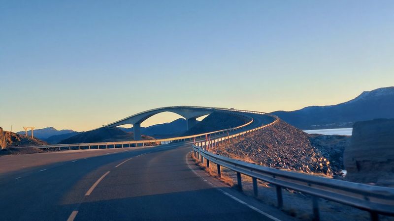
Picture driving a road that looks like it was designed by someone who wanted to walk on water. The Atlantic Ocean Road in Norway does exactly that — its series of low-lying bridges hop between small islands and rocky outcrops across the open sea, making it one of the most surreal driving experiences anywhere on Earth.
Completed in 1989, the 8.3-kilometer stretch took years to build through brutal North Atlantic storms. During construction, workers endured 12 hurricanes.
The Storseisundet Bridge is the most dramatic section, curving sharply upward before dropping back down in a way that makes drivers feel like they are launching off a ramp into the ocean.
In stormy weather, waves crash over the road entirely, sending white foam across windshields and guardrails. Brave visitors actually seek out bad weather just to experience this wild spectacle.
On calmer days, seals sunbathe on rocks alongside the road and seabirds circle overhead. The surrounding landscape is stark and raw — no lush forests or golden beaches, just gray rock, cold water, and sky.
That raw honesty is exactly what makes the Atlantic Ocean Road unforgettable.
Stelvio Pass – Italy
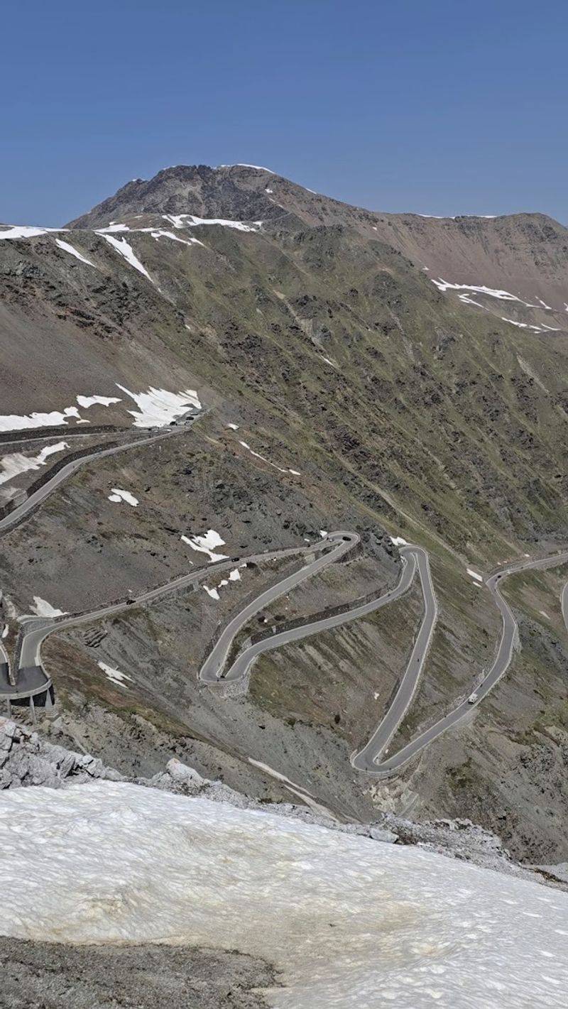
Forty-eight hairpin turns. That is what stands between you and the top of the Stelvio Pass in the Italian Alps.
At 2,757 meters above sea level, it is one of the highest paved mountain passes in the Alps, and it has been making drivers sweat — with excitement and nerves — for nearly 200 years.
Built between 1820 and 1825, the road was originally constructed for military and trade purposes. Today it is a pilgrimage site for driving enthusiasts, motorcyclists, and cyclists who want to test themselves against its relentless switchbacks.
The famous British motoring show Top Gear once called it the greatest driving road in the world.
From the top, the views are absolutely staggering — a sea of jagged Alpine peaks stretching in every direction, with the road zigzagging below like a ribbon dropped from a great height. Snow lingers on the upper sections well into summer, adding a dramatic contrast to the green valley far below.
The pass is only open from late spring to early autumn, so timing matters. Every year, thousands of drivers make the climb just to say they conquered the Stelvio.
Autobahn – Germany

Speed limits? On certain stretches of Germany’s Autobahn, those are optional.
About a third of the entire network has no posted speed limit, making it one of the only major highway systems in the world where drivers can legally push their cars to the absolute maximum. Sports car owners absolutely love this fact.
The Autobahn network spans roughly 13,200 kilometers across Germany and is one of the most efficiently maintained road systems on Earth. The idea for a high-speed national highway began in the 1920s, and construction accelerated dramatically in the 1930s.
Today it handles millions of vehicles every day, from economy hatchbacks to semi-trucks.
Contrary to popular belief, the Autobahn is not a free-for-all racetrack. Strict lane discipline rules apply — slower vehicles stay right, overtaking happens only on the left.
Reckless driving is taken extremely seriously. The road surface is maintained to extremely high engineering standards, and rest stops along the way are clean, well-stocked, and surprisingly pleasant.
Germany’s driving culture treats the Autobahn with a kind of national pride. It is not just a road — it is a statement about precision, efficiency, and yes, a healthy love of speed.
Pan-American Highway – Americas

No highway on Earth covers more ground than the Pan-American Highway. Stretching approximately 30,000 kilometers from Prudhoe Bay in Alaska all the way down to Ushuaia at the southern tip of Argentina, it passes through 14 countries and nearly every type of landscape imaginable — Arctic tundra, tropical jungle, high-altitude desert, and everything in between.
The concept was born at an international conference in 1923, with the goal of physically connecting the entire Western Hemisphere by road. The dream largely came true, with one famous exception: the Darien Gap, a roughly 100-kilometer stretch of impassable jungle and swamp on the Colombia-Panama border where no road exists.
Adventurers have attempted to cross it, but it remains one of the wildest places in the Americas.
Driving the full route is a true expedition, taking months to complete and requiring serious planning. Altitude sickness is a real concern in the Andes, border crossings require careful paperwork, and road conditions vary wildly between countries.
Despite the challenges, thousands of long-distance travelers attempt sections of it every year. The Pan-American Highway is less a single road and more a living, breathing thread stitching two continents together.
Trans-Siberian Highway – Russia
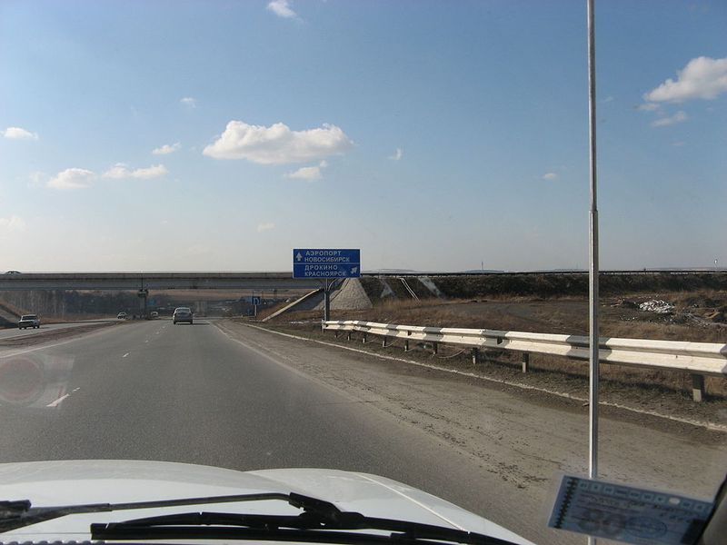
Russia is enormous — and the Trans-Siberian Highway makes sure you feel every single kilometer of that. Spanning over 11,000 kilometers from St. Petersburg in the west to Vladivostok on the Pacific coast, it is one of the longest highways within a single country on the planet.
The sheer scale of it is almost difficult to comprehend.
Unlike its famous rail counterpart, the Trans-Siberian Railway, the highway is not a glamorous tourist attraction. Much of the route passes through raw, unforgiving Siberian wilderness — endless taiga forests, frozen plains, and towns so remote that a broken-down vehicle can become a genuine emergency.
Road conditions range from decent to dangerously rough depending on the season.
Winter driving on this highway is an extreme sport in itself. Temperatures can plunge to minus 50 degrees Celsius in some regions, and sections of road built over permafrost can become unstable as ground conditions shift.
Summer brings mud, mosquitoes, and flooded sections. Yet adventurous drivers from around the world attempt this journey every year, drawn by the sheer wildness of it.
Crossing Russia by road is not comfortable — but it is absolutely unforgettable.
Garden Route – South Africa
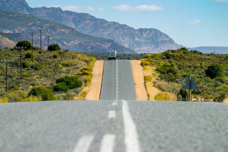
Few roads in Africa pack as much variety into a single drive as South Africa’s Garden Route. Running about 300 kilometers along the southern Cape coast between Mossel Bay and Storms River, it earns its poetic name with every kilometer — forests so dense and green they feel almost tropical, beaches that look airbrushed, and mountains that roll gently to meet the sea.
The town of Knysna is a beloved highlight, sitting beside a famous lagoon framed by dramatic rocky cliffs called the Heads. Nearby, the Tsitsikamma National Park offers ancient forests where yellowwood trees tower overhead and suspension bridges swing above wild river gorges.
Wildlife sightings along the route are common — keep an eye out for vervet monkeys and rare Knysna elephants.
Whale watching is another major draw, particularly around Hermanus just west of the route, where southern right whales come to breed between June and December. Bungee jumping from the Bloukrans Bridge — one of the highest commercial bungee jumps in the world — attracts thrill-seekers from every continent.
Whether you are a nature lover, a foodie chasing fresh oysters, or an adventure junkie, the Garden Route delivers something genuinely special at every turn.
Amalfi Coast Road – Italy
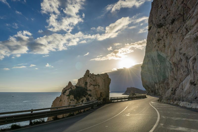
Clinging to vertical cliffs above the sparkling Mediterranean, the Amalfi Coast Road is the kind of drive that makes your jaw drop and your knuckles white at the same time. The SS163 highway stretches about 50 kilometers between Sorrento and Salerno in southern Italy, threading through some of the most jaw-dropping coastal scenery in all of Europe.
The road is famously narrow — barely wide enough for two vehicles to pass in places — which makes encounters with tour buses a true test of patience and nerves. But those who push through are rewarded with postcard-perfect views of pastel-colored villages tumbling down cliffsides into the blue sea.
Positano, Amalfi town, and Ravello are the standout stops along the way.
Lemon groves perfume the air along much of the route, and the region is famous for its limoncello liqueur made from these same fragrant fruits. Seafood restaurants perched on terraces above the water offer some of the freshest meals in Italy.
The road was designated a UNESCO World Heritage Site in 1997 — a rare honor for a highway. Spring and early autumn are the best times to visit, before summer traffic turns this gorgeous stretch into one long, scenic traffic jam.
Karakoram Highway – Pakistan & China
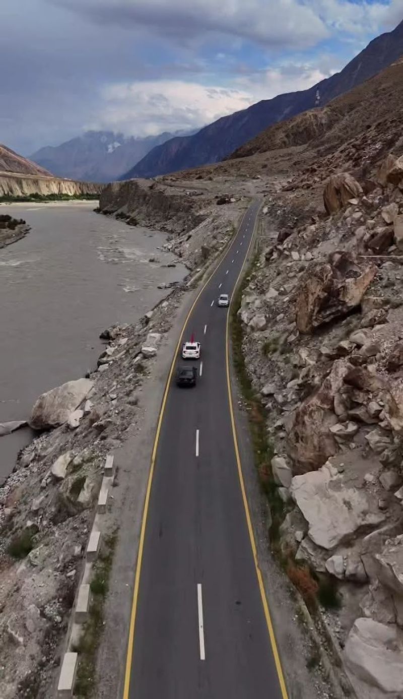
At elevations reaching 4,693 meters above sea level, the Karakoram Highway earns its reputation as the highest paved international road in the world. Connecting Kashgar in China to Hasan Abdal in Pakistan, this extraordinary route stretches approximately 1,300 kilometers through some of the most extreme mountain terrain on the planet — cutting through the Karakoram, Himalayan, and Hindu Kush mountain ranges simultaneously.
Construction of the highway was a monumental human achievement. Over 20 years of labor by Pakistani and Chinese workers, completed in 1979, resulted in more than 800 worker deaths — largely due to rockslides and avalanches.
The highway is sometimes called the “Eighth Wonder of the World” in recognition of what it took to build it.
Traveling it today is a raw, humbling experience. The Hunza Valley, one of the most scenic sections, is surrounded by towering snow-capped peaks including Rakaposhi and Ultar Sar.
Attabad Lake — a vivid turquoise reservoir created by a massive 2010 landslide — now sits alongside the road like a stunning, accidental masterpiece. Rockslides and road closures remain common, especially after heavy rains.
But for travelers willing to embrace the unpredictability, the Karakoram Highway offers scenery that is simply unmatched anywhere on Earth.
Route 1 – Iceland
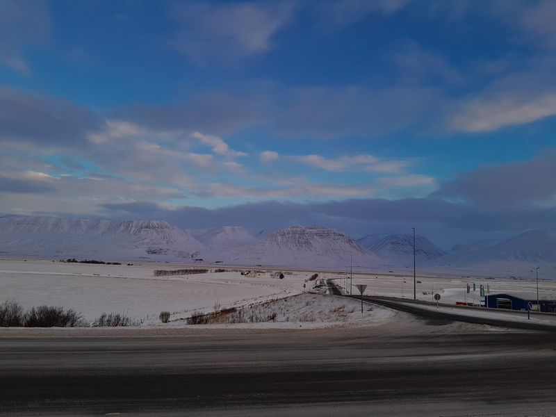
Iceland’s Route 1 — known as the Ring Road — does something no other highway on this list can claim: it circles an entire country. All 1,332 kilometers of it loop around the island of Iceland, connecting its most dramatic natural wonders in a single continuous drive.
Waterfalls, volcanoes, glaciers, geysers, and black sand beaches all make appearances along the way.
The road was not fully completed until 1974, largely because the remote eastern fjords were so difficult to connect. Today, most drivers complete the full loop in about one to two weeks, stopping constantly because Iceland makes it nearly impossible to drive more than twenty minutes without something extraordinary appearing out of the mist.
Seljalandsfoss and Skogafoss waterfalls are early highlights heading east from Reykjavik. The glacier lagoon at Jokulsarlon — where icebergs float silently in a mirror-still lake — is perhaps the most otherworldly spot on the entire route.
In winter, the northern lights often dance across the sky above the road. In summer, the midnight sun means you can drive at 2 a.m. in broad daylight.
Iceland’s Ring Road is not just a highway — it is a full-sensory experience unlike anything else on Earth.
Highway 1 – Australia
Wrapping itself around an entire continent, Australia’s Highway 1 holds the title of the longest national highway in the world. Stretching approximately 14,500 kilometers, it circles the Australian coastline like a giant ring, connecting every major coastal city — Sydney, Melbourne, Adelaide, Perth, Darwin, and Brisbane — in one continuous route.
Unlike most famous highways that are defined by a single dramatic landscape, Highway 1 is remarkable for its sheer variety. It passes through tropical rainforest in Queensland, barren Nullarbor Plain in South Australia and Western Australia, red-rock gorges in the Northern Territory, and lush green coastlines in New South Wales and Victoria.
The Nullarbor Plain section is one of the most famous stretches of straight road anywhere on Earth — the highway runs in a virtually unbroken straight line for about 146 kilometers without a single bend. Roadhouses appear every few hundred kilometers, offering fuel, cold drinks, and a welcome break from the hypnotic flatness.
Kangaroos are a very real driving hazard at dawn and dusk, particularly in rural sections. Driving the full loop takes several weeks at minimum.
Most travelers tackle individual sections, but the ambitious few who complete the entire circuit earn serious bragging rights.
Chapman’s Peak Drive – South Africa
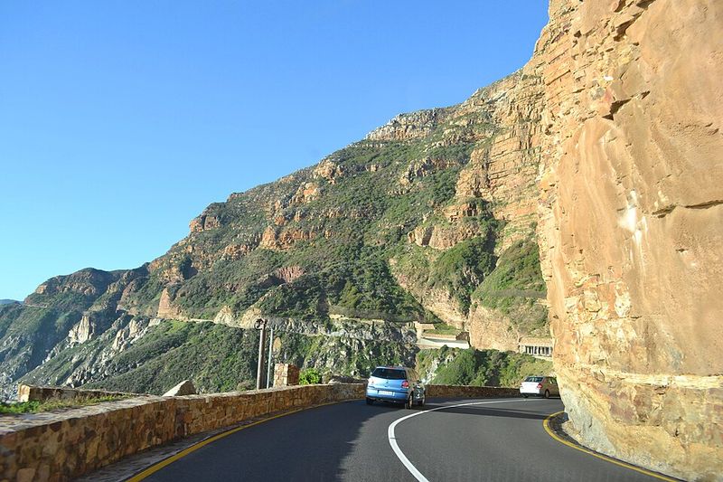
Just 9 kilometers long, Chapman’s Peak Drive near Cape Town, South Africa, proves that a road does not need to be long to be legendary. Carved directly into the face of Chapman’s Peak — a 593-meter mountain that plunges straight into the Atlantic Ocean — this route is a masterpiece of engineering and natural drama packed into a very short stretch of tarmac.
Construction began in 1915 and took six years to complete, with workers drilling and blasting into solid granite cliffs by hand. The finished road features 114 curves and passes through nine tunnels bored straight through the rock face.
Views from the roadside pullouts are spectacular — Hout Bay glitters below on one side while the open Atlantic stretches to the horizon on the other.
The road was closed for several years in the early 2000s after falling rocks caused serious accidents. A major rockfall protection system was installed, including wire mesh nets and canopies bolted into the cliff face, before it reopened in 2003.
Sunset drives are particularly popular — the orange and pink light reflecting off the ocean and cliffs creates a scene that photographers chase obsessively. Chapman’s Peak Drive is short, yes, but every single meter delivers something extraordinary.
Hana Highway – Hawaii, USA
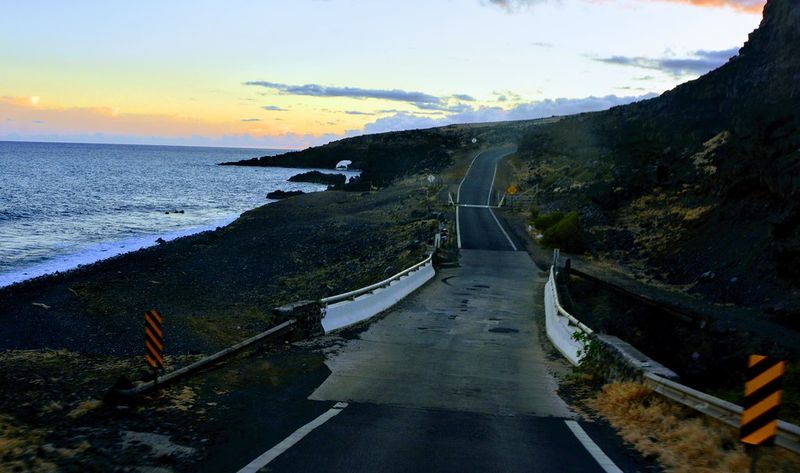
More than 600 curves and 59 bridges crammed into just 64 kilometers — the Hana Highway on the island of Maui, Hawaii, is not messing around. This legendary road winds along the northeastern coastline of Maui through some of the most lush, dripping-wet tropical rainforest in the entire United States, and it demands your full attention from the first turn to the last.
The journey from Kahului to the small town of Hana takes most drivers three to four hours one way, despite the short distance. That is because the road narrows to a single lane in many sections, dozens of one-lane bridges require drivers to take turns, and the sheer number of waterfalls, swimming holes, and scenic pullouts make stopping practically mandatory.
Twin Falls, Wailua Falls, and the black sand beach at Waianapanapa State Park are among the standout stops along the way. Banana bread stands operated by local families appear roadside — a warm, sweet reward after navigating all those curves.
Many visitors make the mistake of rushing to reach Hana quickly. Experienced road-trippers know the real magic is in slowing down and savoring every dripping, flower-scented, waterfall-splashed kilometer of this extraordinary Hawaiian highway.


