Some hikes make you work hard for a single reward. This one hands you four waterfalls, a lush forest, and a creek-side stroll all within a 1.6-mile loop that most hikers can finish in under two hours.
The trail sits tucked into the foothills east of the Willamette Valley in Oregon, and it costs nothing to park or enter. Whether you are a first-time hiker, a parent with young kids, or someone who just wants to spend a morning surrounded by moving water and tall trees, this loop delivers more than most trails twice its length.
I have hiked it in early spring when the falls were roaring and in late summer when they were softer but still stunning, and both times the place left me quietly impressed and already planning a return visit.
The Park Address, Location, and First Impressions
McDowell Creek Falls County Park sits at 43170 McDowell Creek Dr, Lebanon, OR 97355, tucked into the forested hills of Linn County about 14 miles east of Lebanon in the Cascade foothills. The drive out there already sets the mood, with the road narrowing and the trees closing in around you as you climb away from the valley floor.
The main parking lot has restroom facilities, which is a welcome detail on any trail. There is no parking fee and no entry fee, which feels almost too good to be true for a park rated 4.8 stars by over 1,200 visitors.
The park is managed by Linn County Parks and is open daily from 7 AM to 8 PM, so you have a generous window to plan your visit.
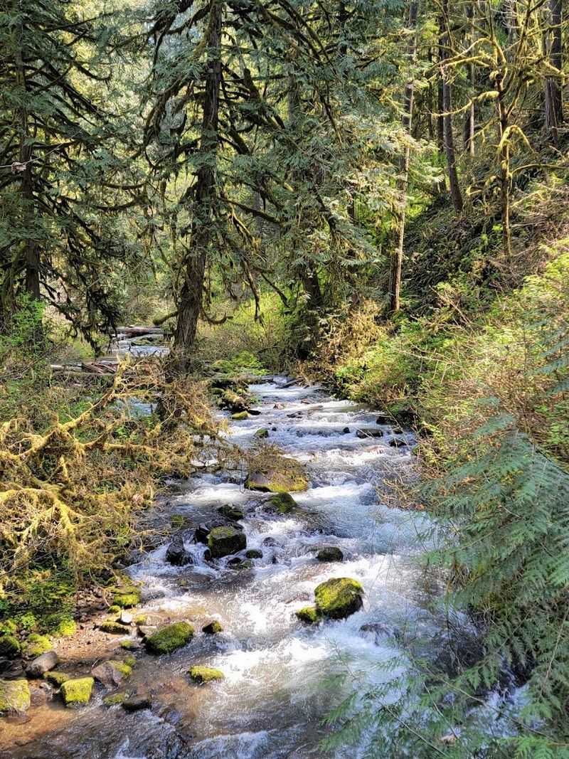
The trailhead is clearly marked from the main lot, and the forest greets you almost immediately with that cool, damp air that only old Oregon woods seem to produce. Tall Douglas firs and big-leaf maples shade the path, and the sound of McDowell Creek reaches you before you even spot the water.
First impressions here rarely disappoint, and the trail wastes no time proving it belongs on your Oregon bucket list.
The 1.6-Mile Loop Trail Overview
The full loop at McDowell Creek Falls County Park clocks in at roughly 1.6 miles, which sounds short until you realize the trail packs in four waterfalls, multiple wooden bridges, steep staircases, creek crossings, and forest overlooks all within that compact distance. It is one of the most efficient trails I have ever walked in Oregon.
The route can be started from either the upper or lower parking area. Most hikers begin at the lower lot near the restrooms and work their way up through the canyon, crossing bridges and climbing toward the upper falls before looping back down.
The elevation gain is moderate, with the steepest section being a set of wooden stairs rather than a long grinding climb.
Trail markings are minimal, so downloading an offline map before you arrive is genuinely useful advice, especially since cell service in the canyon is unreliable. That said, the paths are well-worn and easy enough to follow with a little attention.
The whole loop typically takes between one and two hours at a relaxed pace, making it an ideal morning outing that still leaves the rest of your day wide open for other adventures.
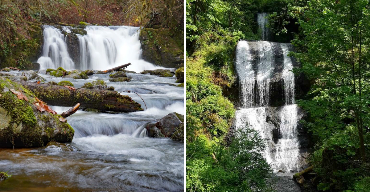
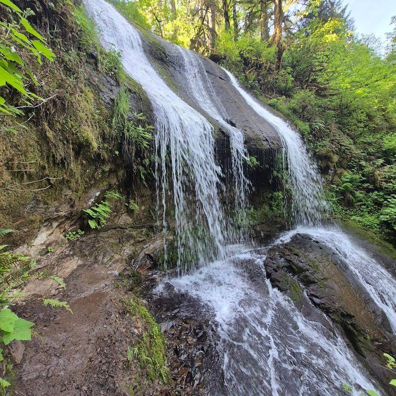
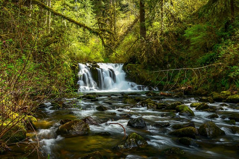
Royal Terrace Falls, the First Showstopper
Royal Terrace Falls is the kind of waterfall that stops you mid-stride. At roughly 119 feet tall and spread across a wide, layered basalt face, it is the most dramatic of the four falls on the loop and the one most hikers remember longest after the visit.
The water fans out across multiple rock tiers rather than dropping in a single plunge, which creates a curtain effect that changes character depending on the season. In early spring or after a heavy rain, the falls thunder with force and spray mist onto the viewing area.
By late summer, the flow softens into something more delicate, though no less photogenic.
A viewing platform and a lower bridge both offer excellent vantage points, and the lower bridge in particular gives you a face-on perspective that makes the full height of the falls land with real impact. Photographers who visit regularly say the soft morning light filtering through the canopy creates ideal conditions before 10 AM.
Standing at that bridge with the sound of falling water bouncing off the canyon walls is one of those small moments that reminds you exactly why you drove out here in the first place.
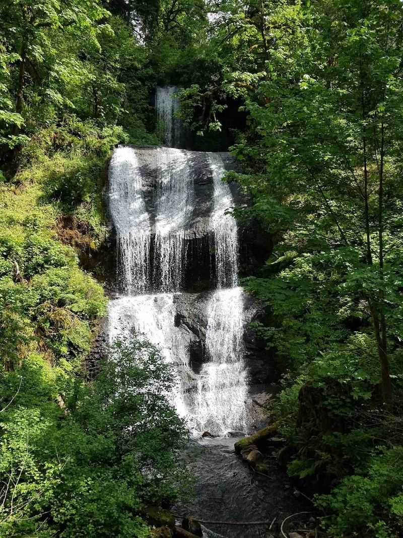
Majestic Falls, the Crown of the Canyon
The name Majestic Falls sets a high bar, and somehow the waterfall actually clears it. This is the tallest single-drop fall in the park, plunging roughly 39 feet into a dark basalt pool at the base of a narrow canyon slot.
The surrounding rock walls are draped in moss and fern, giving the whole scene a rich, layered green that no photograph fully captures.
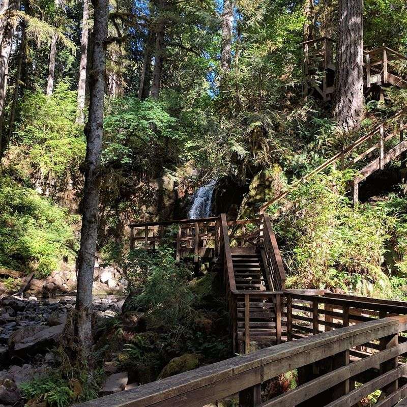
Getting to Majestic Falls involves the famous staircase section of the trail, a steep wooden stairway with handrails that delivers you to an upper viewing platform with a top-down perspective of the falls. The stairs are the most physically demanding part of the entire loop, but they are manageable for most ages, and I watched a parent navigate them with a toddler on their shoulders without too much trouble.
From the top of the stairs, the height of the canyon becomes clear in a way that genuinely earns the word majestic. Looking down at the pool below and then back at the falls framed by old forest growth, you get a sense of scale that the lower trail does not give you.
The climb is worth every step, and your legs will agree once you reach the top and take in that view.
Lower and Upper Falls, the Quieter Pair
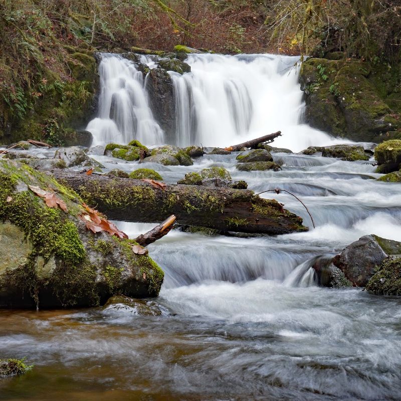
Not every waterfall needs to be a headliner. The lower and upper falls along the McDowell Creek loop play a supporting role, but they add real texture to the hike and reward walkers who take their time rather than rushing between the main attractions.
The lower falls are gentle and wide, spreading across smooth creek stones in a way that feels more like a long rapid than a traditional drop. Kids love this section because the water is accessible and the banks are easy to stand near without any real risk.
The upper falls sit higher on the creek and tend to run stronger earlier in the year, with the flow narrowing and quickening as it approaches the drop.
Together, the four waterfalls on this trail create a rhythm that keeps the hike feeling fresh from start to finish. You never walk more than a few minutes without a new sound or view to pull your attention forward.
The park has been compared by some visitors to a smaller, quieter version of Silver Falls State Park, and while the scale is different, the spirit of discovery on this trail feels just as rewarding. Each waterfall earns its own stop.
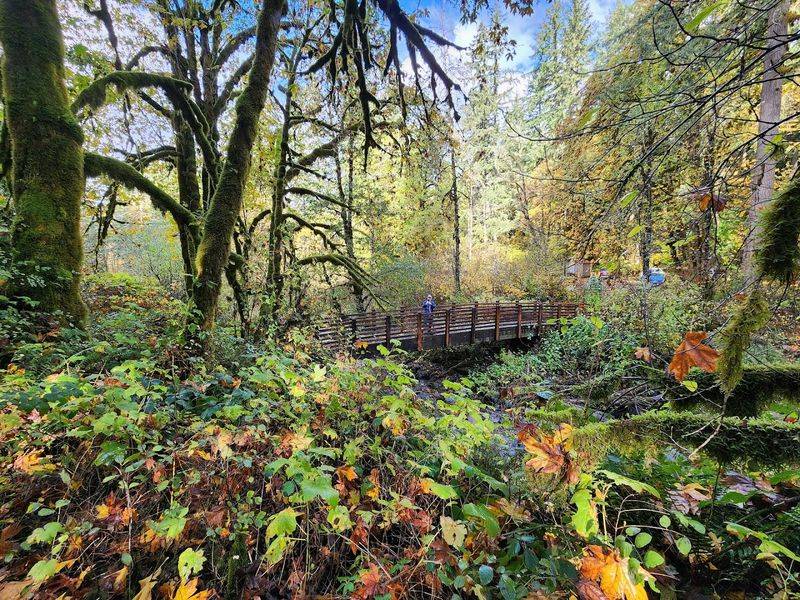
The Wooden Bridges and Creek Crossings
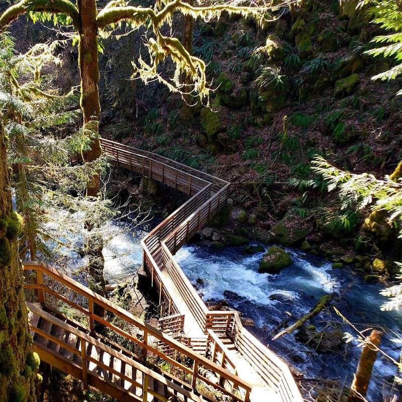
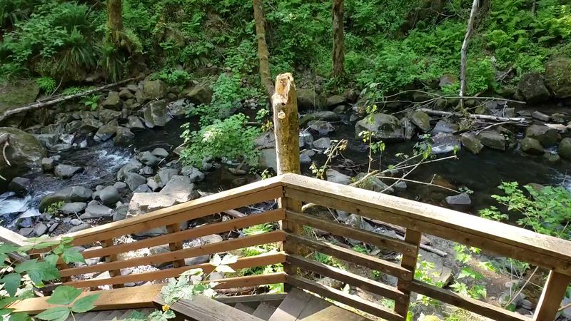
A good bridge on a hiking trail is underrated. The wooden bridges along the McDowell Creek loop do more than just get you across the water; they frame some of the best views on the entire hike and serve as natural stopping points where you can lean on the railing and just watch the creek move below you.
There are several bridge crossings on the loop, and each one offers a slightly different perspective on the canyon. The lower bridge near Royal Terrace Falls is widely considered the best single viewpoint in the park, putting you eye-level with the base of the falls and giving you the full sense of its width and height simultaneously.
The upper bridges cross the creek at narrower points where the water moves faster and the forest presses in more tightly on both sides.
The bridges are well maintained, though they can get slick with moisture during wet months, so grip-soled footwear is a smart choice year-round on this trail. During winter and early spring, a light mist from the falls sometimes coats the bridge planks, so stepping carefully pays off.
These crossings are small moments, but they are consistently among the most photographed spots in the park for good reason.
Best Time to Visit and Seasonal Changes
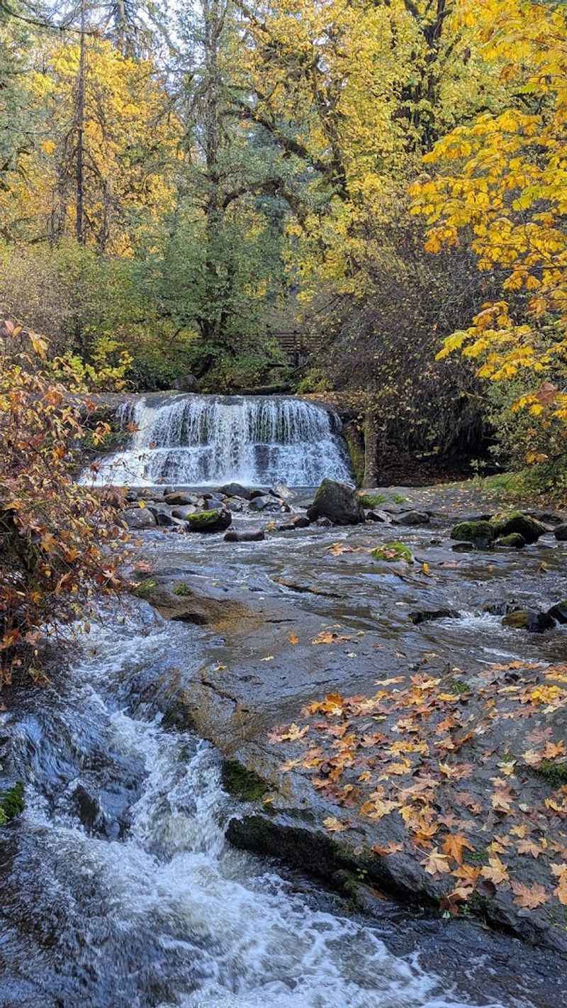
Timing your visit to McDowell Creek makes a real difference in what you experience. The falls run at their most powerful from late fall through early spring, when Oregon rain keeps the creek full and the water drops with genuine force.
February and March visits often come with mist, dramatic flow, and that deep green saturation that makes Pacific Northwest forests look almost surreal.
Summer visits are quieter in terms of water volume, especially during hot dry stretches, when the falls shrink noticeably. Two consecutive hot summers reduced the flow enough that some visitors noted the difference, though the forest and trail remain beautiful regardless of the season.
Fall brings a middle ground, with decent water levels and the added bonus of changing leaf color in the canopy above the creek.
Weekday mornings are consistently the least crowded times to visit, and arriving right at the 7 AM opening gives you the best chance of having the bridges and viewpoints to yourself. The park is open seven days a week until 8 PM, so late afternoon visits in summer also work well when the angle of the light softens and the forest takes on a warmer tone.
Plan ahead, and the timing rewards you generously.
Trail Difficulty, Stairs, and Who Can Handle It
The McDowell Creek loop earns its reputation as an accessible trail for most fitness levels, but it does come with one section that catches people off guard: the stairs. The wooden staircase near Majestic Falls is steep, with high individual steps that require some effort, particularly on the descent when wet wood can be slippery underfoot.
A walking stick or trekking poles make a real difference on the staircase, and the handrails are solid enough to use confidently. Visitors regularly complete the loop with young children, and one reviewer mentioned making the climb with a toddler on their shoulders, which speaks to how manageable it is with a little determination.
That said, anyone with knee concerns or limited mobility should factor the stairs into their planning.
Outside of the staircase, the trail is mostly flat to gently rolling, with some rooted and muddy sections that warrant sturdy footwear. The park gets wet, and the ground stays soft for much of the year, so waterproof trail shoes are a better choice than casual sneakers.
Kids generally handle the trail well and tend to find the bridges and water access points exciting enough to power through any tired-leg complaints. The loop rewards effort without demanding too much of it.
Wildlife, Plant Life, and Forest Atmosphere
The forest at McDowell Creek has a quality that is hard to describe without sounding overly dramatic, but the density of green here is genuinely striking. Sword ferns carpet the ground in thick clusters, mossy boulders line the creek banks, and the canopy overhead is a layered mix of Douglas fir, big-leaf maple, and red alder that blocks enough light to keep the canyon cool even on warm days.
Birdsong is a constant companion on this trail, with the sound of water mixing with the calls of thrushes and wrens that are heard more often than they are seen. The creek itself supports a healthy ecosystem, and it is not unusual to spot small fish holding position in the clear pools below the bridges.
Dogs are welcome on the trail on a leash, and the creek access points make it a popular spot for pups who enjoy wading.
The plant life on this trail has drawn photographers and naturalists for years, and it is easy to see why. Even without the waterfalls, the forest floor alone offers enough visual interest to fill a morning of exploration.
Every fallen log is draped in moss, every rock face is softened by lichen, and the whole corridor feels like a place that has been quietly growing for centuries without much interference from the outside world.
Practical Tips, Parking, and Planning Your Visit
Free parking is one of the most pleasant surprises about McDowell Creek Falls County Park, especially given how polished the trail experience is. Both the upper and lower parking areas are free, and the lower lot includes restroom facilities, which makes it the better starting point for families or anyone planning to spend more than an hour on the trail.
Cell service in the canyon is unreliable to nonexistent, so downloading an offline map before you leave home is a practical step rather than an optional one. The trail signs are minimal, and while the paths are generally easy to follow, having a map on your phone prevents the mild confusion that some first-time visitors mention.
The park phone number is +1 541-967-3917 if you need to call ahead for conditions or closures.
Mud is a real factor during wet months, and the wooden bridges and stairs can become genuinely slippery after rain. Waterproof boots or trail shoes with good grip make the hike safer and more enjoyable.
The park opens at 7 AM and closes at 8 PM every day of the week. No fees, no reservations, no crowds if you time it right.
Sometimes the best hikes are also the most straightforward ones to plan, and this one fits that description perfectly.


