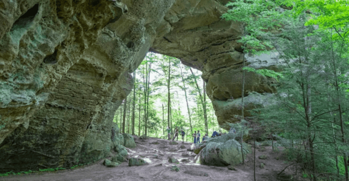
Deep in the rugged hills of Scott County, Tennessee, two enormous sandstone arches rise out of the forest floor like nothing else east of the Mississippi River. These natural formations are so large that most people who see them for the first time simply stop and stare.
The area surrounding them covers roughly 1,500 acres inside Big South Fork National River and Recreation Area, offering trails, overlooks, and a whole lot of natural wonder. This article breaks down everything worth knowing before making the trip, from the drive in to the hike itself and all the details in between.
The Two Arches and What Makes Them Record-Worthy

Not all natural arches are created equal, and these two make that point very clearly. The North Arch has a clearance of 51 feet, a span of 93 feet, and a deck height of 62 feet.
Those numbers alone would make it a standout anywhere in the eastern United States.
Then there is the South Arch, which is even larger. Its clearance reaches 70 feet, its span stretches 135 feet, and the deck sits 103 feet above the ground below.
Together, they hold the title of the most impressive rock arches east of the Mississippi River.
Both arches formed through a geological process involving the erosion of sandstone over millions of years. The rock type here is part of the same formation that shapes much of the Big South Fork landscape.
Standing beneath either arch and looking up makes the scale of that geological timeline feel surprisingly real and immediate.
The Gravel Road That Earns Its Reputation

The access road to Twin Arches is one of the first things people mention when describing the trip, and for good reason. About 5.5 miles of gravel and dirt separate the paved highway from the trailhead parking area, and that stretch has a personality all its own.
On dry days, the road is generally passable for most standard vehicles, with only the occasional pothole requiring a careful swerve. After rain, conditions change quickly.
The road can become muddy and slippery, though it typically remains accessible by car with cautious driving.
The slow pace of the drive actually serves a purpose beyond necessity. The surrounding woodland gradually shifts as the road descends deeper into the park, and the transition from open road to enclosed forest canopy sets the tone for what lies ahead.
Drivers who rush this stretch miss a natural preview of the landscape that the arches themselves are carved from. Patience here pays off in more ways than one.
What the Trailhead Has Waiting for You

After the long gravel drive, the trailhead parking area offers a few welcome amenities. Pit toilets are available on site, making it the last reliable restroom stop before the hike begins.
Several picnic tables and fire rings are also scattered around the area, which makes it a reasonable spot for a pre-hike break or a post-hike meal.
A trailhead map is posted at the start of the path, though some hikers have noted that the signage along the trail itself could be clearer in certain spots. Taking a photo of the map before heading out is a smart habit that saves confusion later.
The parking area tends to stay relatively uncrowded, especially on weekday mornings or during the cooler months. Arriving early on weekends during spring and fall increases the chances of having the trail mostly to yourself, which makes a noticeable difference when trying to take unhurried photos of the arches without other groups in the frame.
Choosing Between the Short Loop and the Long One

Two main trail options exist at Twin Arches, and the choice between them shapes the entire experience. The short loop covers approximately 1.2 miles round trip and brings hikers directly to both arches before looping back to the parking area.
Most people complete it in about an hour, depending on pace and how long they linger at the formations.
The longer option connects to a broader trail network within Big South Fork, extending the hike to around five miles total. This version passes additional features including sandstone bluffs, forested ridges, and connections to other destinations within the park such as Charit Creek Lodge.
For first-time visitors or families with younger children, the short loop delivers the main attraction without overwhelming effort. Those who have already seen the arches and want to explore more of the surrounding landscape will find the longer route rewarding.
Either way, the trail system is generally well maintained and clearly marked at the major decision points along the path.
The Stairs That Everybody Talks About

No honest account of the Twin Arches hike skips the stairs. Wooden steps have been built into the steepest sections of the trail, and while they make the descent manageable, they are genuinely vertical in places.
Hikers with knee concerns or limited mobility should factor this into their planning before committing to the trail.
The most talked-about section drops down between the two arches, where the staircase descends sharply enough that handrails become useful rather than decorative. On the return route, a long staircase heading upward tests the legs in a different way, though most hikers report that the challenge feels worthwhile once the arches are in sight.
Families have completed the trail with young children and even small dogs, though agility and attentiveness matter more here than on a flat path. The key is moving at a steady pace rather than rushing, especially on wet or damp steps, which can become slippery after rain or morning moisture settles on the wood.
The Tunnel That Catches Hikers Off Guard

Hidden within the Twin Arches trail is a feature that does not always make it onto the main attraction list but consistently surprises hikers who find it. Near the second arch, a natural tunnel passes through the rock, short enough to walk through but low enough to require a slight duck in certain spots.
The tunnel adds a playful element to a hike that is already packed with geological interest. Kids tend to love it, and adults who were not expecting it usually stop for a second look before deciding to pass through.
It connects two sections of the trail and serves as a practical route as much as a curiosity.
Details like this are part of what makes the Twin Arches loop feel more layered than a simple out-and-back hike. The arches themselves are the headline, but the tunnel, the overlooks, the bluffs, and the varying terrain all contribute to a trail that holds interest from the first step to the last.
Best Seasons to Make the Trip

Timing a visit to Twin Arches makes a genuine difference in the overall experience. Spring and fall consistently stand out as the strongest seasons for the hike.
Spring brings wildflowers and cooler temperatures, while fall delivers the kind of leaf color that makes every overlook worth stopping at twice.
Summer visits are possible but come with trade-offs. Heat and humidity build quickly in the Tennessee highlands, and the enclosed forest canopy offers limited relief on the steeper sections.
Tick activity also peaks during summer months, adding another layer of preparation to the planning process.
Winter is surprisingly workable for those prepared for cold temperatures and potentially icy steps. The bare trees open up views that are completely hidden during leafy months, and trail traffic drops off considerably, giving solo hikers and small groups a level of quiet that is hard to match during peak season.
The arches look different in every season, which gives returning visitors a genuine reason to come back.
Connecting to Charit Creek Lodge and Beyond

The Twin Arches trail does not exist in isolation. It connects to a broader network of paths within Big South Fork National River and Recreation Area, and one of the more notable destinations along that network is Charit Creek Lodge.
The lodge sits in a remote valley and is accessible only by foot or horseback, making it one of the more distinctive overnight options in the southeastern United States.
Backpackers passing through the Twin Arches area sometimes carry full packs destined for Charit Creek or other backcountry campsites within the park. Seeing a guided group with loaded packs near the trailhead is not unusual, especially during spring and fall when conditions favor multi-day trips.
The longer five-mile loop from Twin Arches feeds into this wider trail system and gives day hikers a taste of the terrain that connects the arches to the rest of the park. For those with extra time and interest, the connections here open up a much larger landscape worth exploring over multiple visits.
Sandstone Bluffs Beyond the Arches

The arches get top billing, but the sandstone bluffs running along the loop trail deserve their own moment of recognition. These formations line sections of the path and rise in layers that reveal the geological history of the region in a way that feels both accessible and impressive without requiring any background in earth science.
The same erosion processes that carved the arches over millions of years also shaped the bluffs, the overhangs, and the scattered boulders that appear throughout the hike. The consistency of the sandstone color, a warm tan deepening to orange in certain light conditions, gives the entire trail a visual coherence that ties the individual features together.
Photographers who take the full loop rather than just the short arch route tend to come away with a much richer set of images. The bluffs provide dramatic backdrops at multiple points along the path, and the interplay between the rock formations and the surrounding forest canopy creates compositions that change with every shift in the trail direction.
Practical Tips Before Heading Out

A few practical details can make the Twin Arches experience significantly smoother. Sturdy footwear matters on this trail, particularly on the wooden stairs and any wet rock surfaces.
Trail runners or hiking boots with decent grip handle the terrain better than casual sneakers, especially after recent rain.
Water and snacks are worth bringing even for the short loop, since the drive in and the hike together take more time than the mileage alone suggests. There are no services at the trailhead beyond the pit toilets, so arriving prepared is the only reliable option.
Downloading an offline map before losing cell service on the access road prevents navigation confusion at the trailhead. The posted map is helpful but not always detailed enough for hikers unfamiliar with the trail layout.
Tick repellent applied before the hike is strongly recommended from early spring through late fall, and checking clothing and skin thoroughly after returning to the parking area has become a standard part of the post-hike routine for regular visitors to this area.
Why Twin Arches Keeps Drawing People Back

A 4.9-star rating from over 260 individual accounts tells a consistent story about Twin Arches. The trail delivers on its promise in a way that is rare enough to generate genuine enthusiasm rather than polite approval.
First-time visitors frequently describe being caught off guard by the actual scale of the formations after expecting something more modest.
The combination of geological significance, manageable trail length, and the added surprises of the tunnel, the bluffs, and the walkable arch deck creates a layered experience that holds up across multiple visits. Families return with different children at different ages.
Solo hikers come back in different seasons to see how the light and the foliage change the character of the place.
Big South Fork contains dozens of trails and natural features spread across a large and varied landscape, but Twin Arches occupies a particular spot in the park’s reputation that is hard to displace. As the most impressive rock arches east of the Mississippi River, they set a standard that the surrounding 1,500 acres of natural area supports with quiet confidence.
Where Twin Arches Actually Sits on the Map

Twin Arches is located within Big South Fork National River and Recreation Area, near Oneida, TN 37841, in Scott County, Tennessee. The site falls under the management of the National Park Service, and the official trailhead sits at the end of a roughly 5.5-mile gravel and dirt access road.
Getting there requires patience and a reliable vehicle. The road winds through thick woodland before opening up to a modest parking area with pit toilets and a few picnic tables.
The address puts it in the broader Oneida area, which serves as the nearest town for fuel, supplies, and a meal before heading out. Cell service along the access road and at the trailhead tends to be unreliable, so downloading offline maps beforehand is a practical move.
The park is open 24 hours a day, every day of the week, giving hikers plenty of flexibility to plan their visit around weather and daylight.


