Tucked away in the hill towns of western Massachusetts, there is a reservation that manages to pack two of nature’s best features into a single outing. On one side of the road, a three-tier waterfall drops through a rocky gorge and fills a series of natural pools.
On the other side, a trail climbs to a 1,420-foot summit with open views across the Connecticut River Valley. The place draws everyone from casual walkers to more determined hikers, and the trail system is varied enough to keep things interesting no matter which direction you head first.
This article walks through everything worth knowing before making the trip, from parking and trail options to the best times of year to visit and what to expect once you get there.
The Three-Tier Waterfall That Started It All

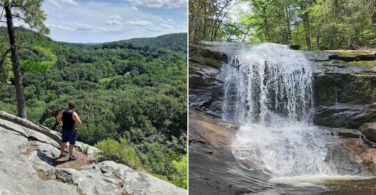
Chapel Falls is the centerpiece of the reservation, and it earns that title without any argument. The waterfall drops in three distinct stages over a series of mossy ledges, with each tier feeding into a shallow pool before spilling into the next level below.
The total drop is modest by New England standards, but the stacked layout gives the falls a dramatic quality that a single-drop waterfall does not always deliver. Each tier has its own character, with the upper stage being the narrowest and the lower pools spreading out wide enough to wade in.
The trail from the parking area to the base of the falls covers only about 400 feet of distance, which means the waterfall is accessible even for people who do not consider themselves hikers. The short approach also makes it a reasonable destination for families with younger children who want a payoff without a long commitment.
Natural Pools and the Famous Water Slide

Below the lowest tier of the falls, Chapel Brook widens into a series of natural pools that have made the reservation a popular warm-weather destination. The pools are shallow in most spots but deep enough in certain areas for a quick dip on a hot afternoon.
The most talked-about feature is a natural rock slide formed by the smooth stone face of one of the lower ledges. Water flows continuously over the surface, creating a slick run that drops into a pool at the bottom.
It is not a commercial attraction with lifeguards or rules, so anyone using it does so at their own pace and judgment.
On busy summer weekends, the pool area can fill up with people, which makes the experience feel more social than solitary. Arriving on a weekday morning tends to give visitors a much quieter time at the water and more room to spread out along the brook.
The 1,420-Foot Summit Across the Road

Directly across Route 116 from the falls trailhead, a second trail climbs toward the high point of the reservation. The summit reaches 1,420 feet in elevation and sits on a ridge that looks out over the surrounding hill towns and the broader Connecticut River Valley to the east.
The climb is steady without being punishing, and the trail passes through a mix of hardwood forest and rocky outcrops before reaching the open ledge at the top. The overlook rock at the summit offers an unobstructed view that rewards the effort of getting there.
The round trip from the parking area to the summit and back covers roughly 4 to 4.5 miles depending on the exact route taken. Combining the summit hike with a stop at the falls on the same visit turns the outing into a full half-day adventure that covers both the reservation’s signature features in a single trip.
Trail Options for Every Pace

The reservation offers more than one way to move through the landscape, which is part of what keeps it interesting for repeat visitors. The short path to the falls suits walkers who want a quick outing, while the Two Bridges Trail and the summit route appeal to hikers looking for more distance and elevation.
The Two Bridges Trail follows Chapel Brook through a stretch of forest before looping back, and it passes through terrain that includes muddy sections, downed trees from past storms, and plenty of wildlife habitat. The trail is well-maintained overall but does require some attention to footing in wet conditions.
Signage at the trailhead has historically been a bit ambiguous, with multiple paths departing from the same small parking area. Checking a trail map from The Trustees of Reservations website before arriving helps avoid taking a longer route than intended, especially for first-time visitors who have a specific destination in mind.
Parking, Access, and Practical Details

The parking area at Chapel Brook Reservation is small, with room for only a limited number of vehicles. On busy summer weekends and fall foliage weekends, the lot can fill up quickly, sometimes before mid-morning.
Arriving early is the most reliable strategy for securing a spot without having to wait.
Overflow parking is available on the shoulder of Route 116 just past the bridge, which adds a bit of walking distance but keeps the visit doable when the main lot is full. There is a portable restroom near the trail entrance, which is a practical convenience that not every small reservation provides.
The reservation is free to access for members of The Trustees of Reservations, and non-members can visit as well under the organization’s standard access policies. No reservation or permit is required for a standard day visit, making it a straightforward destination to add to a day trip itinerary in western Massachusetts.
Best Times of Year to Make the Trip

The reservation changes character noticeably across the seasons, and each time of year brings something different to the experience. Spring is when the waterfall runs at its highest volume, fed by snowmelt and April rain, and the forest floor fills in quickly with new growth during this period.
Summer draws the largest crowds, particularly on weekends, because the pools below the falls offer a rare combination of easy access and natural swimming. The water stays cold even in July and August, which is part of the appeal during hot stretches of weather.
Fall brings a dramatic change to the tree canopy, and the hardwood forest around the reservation turns through shades of orange, yellow, and red during peak foliage weeks in October. Winter visits are possible but require appropriate footwear for icy trail conditions, and the waterfall sometimes develops ice formations around its edges during extended cold periods, which creates a completely different kind of visual.
The History Behind The Trustees of Reservations

Chapel Brook Reservation is part of a network of protected properties managed by The Trustees of Reservations, an organization with roots going back to 1891. It is widely recognized as the world’s oldest land trust, founded in Massachusetts with the goal of preserving places of natural and historic significance for public access.
The organization currently manages more than 120 properties across Massachusetts, ranging from coastal beaches to inland forests and agricultural landscapes. Chapel Brook represents the type of inland hill town property that has defined the organization’s work in the western part of the state.
The conservation of land like Chapel Brook ensures that the waterfall, the summit views, and the brook corridor remain accessible to the public rather than being absorbed into private development. For anyone interested in supporting that mission, membership in The Trustees of Reservations provides free access to all properties and directly funds ongoing land stewardship across the state.
What to Bring on the Trail

The short walk to the falls requires almost nothing in terms of gear, but anyone planning to combine the falls visit with the summit hike should come a bit more prepared. Sturdy footwear with good grip matters on the rocky trail sections, and the terrain near the brook can stay muddy long after rain has passed.
Water is essential on the summit hike, particularly in warmer months when the climb generates real effort. Bringing more than expected is always the right call on a trail that does not have any water sources along the upper section.
A downloadable trail map from The Trustees of Reservations website is worth having on a phone or printed out, since the trailhead signage does not always make the route options immediately obvious to first-time visitors. Bug spray, sunscreen for the exposed summit ledge, and a small snack round out a practical kit for a half-day outing at the reservation.
How Chapel Brook Reservation Fits Into the Region

Ashfield sits in a part of Massachusetts that does not always appear on the radar of travelers focused on the more well-known destinations in the state. The town is about 25 miles north of Northampton and roughly 20 miles east of the Connecticut border, placing it in the heart of the Pioneer Valley hill towns.
The surrounding area includes several other conservation properties, state forests, and small-town centers worth exploring on the same day. Cummington, Conway, and Shelburne Falls are all within easy driving distance and offer their own mix of trails, historic sites, and local character.
Chapel Brook Reservation works well as an anchor for a day trip into this part of western Massachusetts, with the falls and summit providing enough variety to fill a morning and leave the afternoon open for exploring the wider region. The combination of easy access and genuine natural quality makes it a reliable destination that holds up across multiple visits.
Where Chapel Falls Actually Is

Chapel Brook Reservation sits along Route 116 in Ashfield, Massachusetts 01341, in Franklin County in the western part of the state. The reservation is managed by The Trustees of Reservations, a Massachusetts-based conservation organization that has been protecting open land since 1891.
Ashfield is a small hill town with fewer than 2,000 residents, and the surrounding landscape is defined by rolling forested ridges, farm fields, and fast-moving brooks. The drive to the reservation from Northampton takes roughly 30 minutes, while the trip from Springfield runs closer to an hour.
The parking area is right off Route 116, making it easy to find without a complicated approach. There are two separate trailheads at the lot, one leading toward the falls and one heading toward the summit, so knowing which one you want before arriving saves a bit of confusion at the start.


