There is a canyon in Oregon that stretches for 80 miles, drops nearly 4,000 feet deep, and packs more waterfalls, cliff views, and river scenery into one stretch of road than most people see in a lifetime of travel. I had heard the hype, read the trail guides, and still nothing quite prepared me for actually standing at the edge of it.
The Columbia River Gorge National Scenic Area sits just east of Portland, and it delivers the kind of scenery that makes you stop mid-sentence and forget what you were saying. From thundering cascades to golden hilltops, this place earns every bit of its reputation and then some.
Where the Gorge Begins: Location and First Impressions

My first look at the Columbia River Gorge National Scenic Area hit differently than I expected. The address to reach the main visitor area is along the Historic Columbia River Highway in Oregon, and the managing agency can be reached at +1 541-308-1700 or through fs.usda.gov/crgnsa.
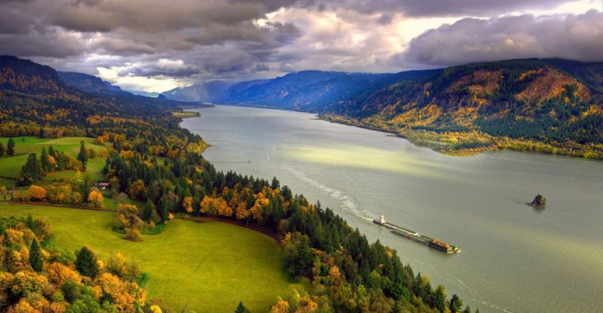
The gorge itself runs along the Oregon-Washington border, with the Columbia River carving a massive corridor right through the Cascade Mountains.
What strikes you first is the sheer scale. The canyon walls rise hundreds of feet above the water, and the river below looks almost calm compared to the drama surrounding it.
The Oregon side is blanketed in dense, moss-covered forest, while the Washington side opens into drier, rolling golden hills.
That contrast alone makes the gorge feel like two completely different worlds separated by a single river. Most visitors start near the western end, close to Portland, where the waterfalls are most concentrated.
The area holds a 4.8-star rating from over 13,000 visitors, and that number tells you everything you need to know before you even arrive.
The Ice Age Left Its Mark Here

The Columbia River Gorge did not form the way most canyons do. While rivers typically carve their paths slowly over millions of years, this gorge owes much of its dramatic shape to something far more sudden and violent: the Missoula Floods.
At the end of the last Ice Age, a massive glacial lake in present-day Montana repeatedly broke through its ice dam, sending walls of water roaring across the Pacific Northwest. Those floods, some of the largest known in Earth’s history, scoured out the gorge walls, rearranged entire hillsides, and left behind the basalt cliffs and canyon shapes we see today.
You can actually see the evidence of this in the rock layers along the canyon walls. The hexagonal basalt columns stacked along the cliffs formed from ancient lava flows, and the flood waters polished and shaped them into what you see now.
Standing at a viewpoint and knowing that ancient floodwaters once roared through this exact spot at unimaginable speed makes the whole landscape feel charged with a kind of raw, geological energy that no photograph fully captures.
Multnomah Falls: The Star of the Show

No single feature defines the Columbia River Gorge more than Multnomah Falls. At 620 feet tall, it is the tallest waterfall in Oregon and one of the most visited natural landmarks in the entire country.
The falls drop in two tiers, and a historic stone bridge arches across the lower section, giving photographers one of the most iconic vantage points in the Pacific Northwest.
The trail to the top is steep but manageable, gaining about 700 feet in elevation over roughly a mile. Reaching the upper viewpoint rewards you with a perspective that most postcard photos never show: looking down at the full cascade from above, with the river valley stretching out behind you.
One practical note worth flagging: parking at Multnomah Falls requires a timed permit reservation during peak season, and visitors who arrive without one will be turned away. The Cascade Locks Historical Museum sometimes has day passes available, so checking there first is a smart move.
The falls are worth every bit of the planning they require, and the roar of the water when you get close is something your memory holds onto for a long time.
Beyond Multnomah: Waterfalls You Should Not Skip

Multnomah Falls gets the most attention, but the gorge is home to dozens of other waterfalls that are just as beautiful and far less crowded. Latourell Falls is one of the first you reach driving east from Portland, and it drops nearly 250 feet straight down a basalt cliff face covered in bright yellow lichen.
The short trail to the base takes about ten minutes and feels like walking into a painting.
Wahkeena Falls offers a series of cascades connected by a loop trail that links back to Multnomah, making it possible to hike between multiple falls in a single outing. Horsetail Falls is another favorite because you can walk directly behind a curtain of water on the trail above it.
Several visitors specifically mentioned parking at Horsetail when Multnomah lots were full, and it turned out to be a better experience for them anyway.
Wahclella Falls Trail is worth the drive to the eastern end of the waterfall corridor. The trail is moderately rocky with a few steep sections, but the payoff is a powerful waterfall tucked into a narrow canyon that feels completely removed from the busier western stops.
Spread your time across several falls and the day becomes genuinely unforgettable.
The Historic Columbia River Highway and Its Legendary Views

Built between 1913 and 1922, the Historic Columbia River Highway was one of the first paved scenic roads in the United States. Engineers designed it specifically to showcase the beauty of the gorge rather than simply move traffic efficiently, and that philosophy shows in every curve and stone guardrail.
Driving it today feels like a trip through both natural beauty and early American road history. The highway passes through dense forest canopies, crosses elegant stone bridges, and pulls you past viewpoint after viewpoint where the Columbia River spreads out far below.
Vista House at Crown Point is the most famous stop along the route, an octagonal stone structure perched on a cliff 733 feet above the river with panoramic views stretching for miles in both directions.
Some sections of the historic highway are now closed to cars and converted into a paved trail for cyclists and hikers, which makes them even more enjoyable. Biking through those sections with waterfalls cascading beside the path and dramatic cliffs overhead is the kind of experience that cyclists talk about for years afterward.
The road itself is as much a destination as anything it leads you to.
Hiking the Gorge: Trails for Every Level

The trail network inside the gorge covers a remarkable range of difficulty levels, which means the area genuinely works for everyone from casual walkers to serious hikers. Short paved paths near the major waterfalls are suitable for families with young children or anyone who simply wants a beautiful walk without a workout.
The trail system is well marked throughout, with clear maps at most major stops that help you plan your route on the fly.
For hikers wanting more challenge, the upper trails linking multiple waterfalls together offer longer, steeper routes with constant forest and canyon views. The hike to the Multnomah Falls lookout point gains elevation quickly, and some sections near the top have narrow trails without guardrails, so non-slip footwear is genuinely important rather than just a suggestion.
Dog Mountain on the Washington side of the gorge is one of the most rewarding harder hikes in the area. The climb is steep and unrelenting, but the summit opens into a massive wildflower meadow in spring with panoramic views of the entire gorge corridor below.
Early morning starts are consistently recommended by experienced visitors to beat the crowds and catch the trails in their quietest, most peaceful state.
Rowena Crest and the Eastern Gorge Scenery

Drive far enough east along the gorge and the scenery transforms completely. The dense, dripping green forests of the western gorge give way to open grasslands, golden hillsides, and a landscape that looks more like the American West than the Pacific Northwest.
Rowena Crest sits at this transition point, and the view from the top is one of the most photographed in Oregon for very good reason.
The viewpoint looks down over a series of tight horseshoe curves in the old highway below, with the Columbia River spread wide in the background and layers of hills rolling away toward the horizon. In spring, the plateau below Rowena blooms with balsamroot and other wildflowers that carpet the ground in bright yellow, creating a scene that photographers plan entire road trips around.
The drive to Rowena Crest from the waterfall corridor takes about 45 minutes, but the shift in landscape makes it feel like an entirely separate destination. Combining a morning at the western waterfalls with an afternoon at Rowena gives you two completely different versions of the gorge in a single day, and that contrast is one of the things that makes this place so hard to fully describe to someone who has not seen it.
Cycling Through the Gorge

Two wheels might actually be the best way to experience the gorge. The converted sections of the Historic Columbia River Highway that are now closed to vehicles offer a paved cycling path that winds through forest, past waterfalls, and along cliff edges where the views open up without warning and stop you mid-pedal.
The path balances gentle stretches with more challenging climbs, so riders of different fitness levels can find their rhythm. What makes cycling here different from most scenic trails is the density of things to see.
Every half mile or so brings a new waterfall, a new viewpoint, or a new section of forest that looks different from the last. Stopping often is not a sign of weakness here; it is simply the correct strategy.
The mix of fresh air, physical effort, and constant natural beauty creates a very specific kind of satisfaction that is hard to replicate anywhere else. Bike rentals are available in the Hood River area for those who do not want to haul their own gear.
Starting early in the morning keeps the path quieter and gives you the best light for photos, especially near the waterfalls where morning mist catches the sun in spectacular ways.
Hood River: The Town That Completes the Trip

Right in the middle of the gorge sits Hood River, a small city that punches well above its weight in terms of what it offers visitors. The town has built a reputation as one of the best outdoor-oriented communities in the Pacific Northwest, and spending time there between gorge adventures feels like a natural extension of the trip rather than a detour.
The downtown area has a walkable main street lined with cafes, gear shops, bakeries, and restaurants that cater to people who have spent the day outside and are ready to eat something substantial. The food scene leans toward fresh, local ingredients, and you will not struggle to find a satisfying meal after a long day of hiking or cycling.
Hood River also sits at one of the windiest points along the gorge, which has made it a legendary destination for windsurfers and kiteboarders. Watching them fly across the river from a waterfront park bench is genuinely entertaining even if you have no intention of getting on the water yourself.
The town also serves as a practical base for multi-day gorge trips, with lodging options that range from simple motels to comfortable hotels with river views.
Best Times to Visit and What to Expect with Crowds

Timing your visit to the Columbia River Gorge makes a significant difference in the experience you have. Summer brings the largest crowds, especially in July and August when school is out and Portland residents head east for weekend escapes.
The most popular spots, particularly Multnomah Falls, can feel genuinely overwhelming on a Saturday afternoon in peak season.
Spring is widely considered the best season for the gorge. Waterfalls run at their fullest thanks to snowmelt and spring rains, wildflowers bloom across the eastern meadows, and the forest takes on a vivid green that photographs beautifully.
Weekday visits in April and May offer the closest thing to a crowd-free experience at the major falls.
Autumn brings a different kind of beauty, with the loop trails around Multnomah lighting up in orange and red foliage that reflects in the pools below the waterfalls. Winter visits are quieter still, and rainy days actually enhance the waterfalls by pushing them to their maximum flow.
Going early in the morning regardless of season is the single most consistent piece of advice from experienced visitors, and it is worth setting that alarm an hour earlier than feels comfortable.
Practical Tips for First-Time Visitors

A little preparation goes a long way at the gorge. The most important thing first-time visitors consistently get wrong is parking.
Multnomah Falls requires a timed parking reservation during peak months, and showing up without one means being turned away at the lot. Booking in advance through the reservation system is essential rather than optional.
The visitor center is a smart first stop for anyone who has not mapped out their route. Staff there provide clear paper maps and up-to-date trail condition reports, which helps you decide where to go based on current conditions and how much time you have.
The maps throughout the area are well designed and make navigation genuinely straightforward even for first-timers.
Footwear matters more here than at most parks. The trails can be slippery from moisture year-round, and some sections near viewpoints are narrow without guardrails.
Waterproof, non-slip shoes are the right call in any season. The weather in the gorge shifts quickly, so layering is smart even on sunny days.
There is a restaurant at Multnomah Falls Lodge for lunch, and the visitor center area has basic amenities, so you will not go hungry if you forget to pack food.
Why the Gorge Stays With You Long After You Leave

Some places are impressive in the moment and fade once you are home. The Columbia River Gorge is not one of them.
The combination of scale, variety, and sensory detail creates a kind of layered memory that keeps surfacing weeks after the trip is over. The sound of a waterfall heard before it comes into view.
The way the river looks impossibly wide from a cliff edge. The smell of wet basalt and forest after rain.
The gorge works on multiple levels simultaneously. It is a geological record, a wildlife corridor, a recreational destination, and a scenic drive all compressed into one accessible stretch of Oregon.
That density of experience in a single day trip from Portland is genuinely rare, and it explains why the area consistently earns five-star reviews from visitors who have traveled widely and still find this place remarkable.
First-time visitors often leave already planning their return trip, mentally noting which trails they missed or which viewpoint they want to revisit in a different season. That pull to come back is perhaps the clearest sign that the Columbia River Gorge delivers something real, something that holds up long after the photos stop getting likes and the trip fades into memory.


