Deep in the Elkhorn Mountains of northeastern Oregon, a high-ridge trail winds through some of the most dramatic alpine scenery in the entire Pacific Northwest. Most hikers come for the sweeping views and the mountain goats that roam the ridgeline without a care in the world.
But tucked into the folds of these ancient peaks are three forgotten gold mines, relics of a mining era that shaped this corner of Oregon more than a century ago. The Elkhorn Crest National Recreation Trail is not just a hike; it is a walk through wild landscape and buried history at the same time, and every step forward feels like turning a page in a story that most people never get to read.
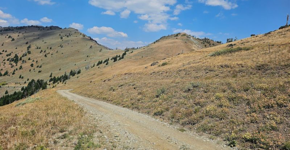
The Trail Itself: A Ridge Walk Above the World

Few trails in Oregon earn a 4.9-star rating with the kind of unanimous enthusiasm that the Elkhorn Crest National Recreation Trail has collected from everyone who has set foot on it. The trailhead is accessible via NF-6510 near Baker City, OR 97814, putting it within reach of travelers coming through northeastern Oregon’s high desert country.
The trail runs along the spine of the Elkhorn Mountains, part of the Wallowa-Whitman National Forest, and it rewards hikers with views stretching across both the western valleys and the eastern high desert simultaneously. On a clear day, the sense of open space up here is almost disorienting in the best possible way.
The full trail stretches roughly 23 miles, but most visitors choose a section and hike it as an out-and-back, which makes it flexible for all fitness levels. The road getting up to the southern trailhead near Baker City is rough and unpaved, but any capable SUV handles it without serious trouble.
The payoff for that bumpy approach is immediate once you crest the ridge and the landscape opens up in every direction.
The Three Forgotten Gold Mines Along the Route

The Elkhorn Mountains were not always just a hiker’s paradise. During the late 1800s, gold fever swept through this range with serious force, and prospectors carved tunnels and claims into the mountainsides with picks and determination.
Three of those old mine sites still sit along or just off the Elkhorn Crest Trail corridor, mostly forgotten by the general public but quietly present for those who know where to look.
The mines date back to an era when Baker County was one of Oregon’s most active gold-producing regions. The Elkhorns yielded placer gold and hard-rock ore, drawing miners who built camps, roads, and supply lines through terrain that now feels remote and untouched.
Today, the mine openings are weathered and partially collapsed, their timber supports grayed by more than a century of alpine winters. They are not marked with flashy signs or interpretive boards, which is part of what makes spotting them feel like a genuine discovery.
Hikers who slow down and pay attention to the hillsides flanking the trail are the ones most likely to notice the dark rectangular shadows that mark where someone once chased a fortune into the rock.
Marble Pass: The Gradual Gateway Into High Country

One of the most popular entry points to the Elkhorn Crest Trail is Marble Pass, and hikers who start here get a gentle introduction to the high country before the terrain demands anything serious from their legs. The first four miles out of Marble Pass roll along at a mostly flat grade, which makes the route accessible to hikers who are not necessarily seasoned mountaineers.
That flat opening stretch is deceptive in the best way, because it lulls you into a comfortable rhythm while delivering non-stop views across open ridgelines. Then, around mile four, a series of switchbacks kicks in and the trail climbs more aggressively toward the upper crest, where the truly panoramic scenery begins.
The Marble Pass approach also passes through terrain that historically connected several of the mining operations in the Elkhorns. Old pack trails used by miners overlap with the modern recreation route in places, and the faint traces of those routes are still visible as parallel depressions in the meadow grass.
Starting here in the afternoon is not recommended since the switchback section at the end can catch hikers in fading light, a lesson that more than one visitor has learned the hard way.
Mountain Goats: The Unofficial Trail Ambassadors

No visit to the Elkhorn Crest Trail is complete without talking about the mountain goats, because these animals have essentially claimed the ridgeline as their personal domain and they are not shy about it. Hikers regularly encounter herds of them within the first few miles, and the goats often approach close enough that you can see the texture of their thick white coats and the calm, slightly judgmental look in their amber eyes.
A herd spotted near the Marble Pass area has been reported by multiple visitors, with goats crossing the trail at a leisurely pace that suggests they have absolutely no concern about human schedules. The animals are most active in the early morning and late afternoon, which happens to coincide with the best light for photography.
Mountain goats in this part of Oregon are a conservation success story. They thrive in the rocky, steep terrain of the Elkhorns, using ledges and cliff faces that would stop most other animals cold.
Watching a goat navigate what looks like a vertical rock wall with complete nonchalance is one of those trail moments that stays with you long after the hike is over.
Fall Colors on the Crest: October’s Best-Kept Secret

October transforms the Elkhorn Crest into something that feels almost theatrical. The larches turn a deep, burnished gold, and the low-growing alpine shrubs shift into shades of red and orange that contrast sharply against the gray granite and blue sky.
The fall color display up here rivals anything in New England, and it happens with almost no crowds to compete with.
The combination of high elevation, open ridgeline, and mixed vegetation creates a color palette that changes noticeably from week to week through September and into October. Visiting in early October tends to hit the peak window for the best display, though weather in the Elkhorns can shift quickly, so checking forecasts before heading up is always a smart move.
The light in October also behaves differently than summer light. The sun sits lower in the sky and hits the ridgeline at an angle that makes the golden larches practically glow from within.
Photographers who make the bumpy drive up the southern access road in October tend to come back with images that look like they were edited for a magazine cover, except no editing was necessary. Nature handled it entirely on its own.
The Old Quarry Stop: A Bonus Discovery

Not far from the southern access route, an old quarry sits off the main path and offers a detour that most hikers do not know to look for. The quarry is not a formal attraction with parking or signage; it is simply there, embedded in the landscape, and visitors who pull over to explore it find a fascinating slice of industrial history layered into the mountain scenery.
The rock face shows clear evidence of past extraction work, with flat cut surfaces and drill marks that contrast with the natural fracture patterns of the surrounding stone. The quarry likely supplied material for road construction or building projects in the region during the early twentieth century, though its exact history is not widely documented in public records.
Stopping at the quarry adds maybe thirty minutes to the approach drive, and the combination of geological interest and historical texture makes it worth the brief pause. The site sits in a small clearing where the forest opens up slightly, giving it a quiet, slightly forgotten atmosphere that fits perfectly with the broader theme of the Elkhorn Crest area.
Ruins and remnants have a way of making the present feel richer, and this quarry does exactly that.
Snow on the Trail: What June Hikers Need to Know

The Elkhorn Crest Trail sits at elevations that keep snow on the ground well into summer, and hikers who arrive in late June expecting fully clear conditions are sometimes surprised to find snow patches still covering sections of the upper trail. End-of-June visits can involve climbing over snow in spots, particularly on the north-facing slopes where the sun has less time to work each day.
This is not a reason to avoid the trail in early summer; it is simply a reason to prepare properly. Traction devices like microspikes are worth bringing along for June hikes, and trekking poles add significant stability on snow-covered sections where the footing is less predictable.
Waterproof boots make the slushy sections far more pleasant to cross.
The snow also adds a visual drama to the landscape that summer hikers miss entirely. Bright white patches against green meadow grass and gray rock create a striking layered look that photographs beautifully.
The contrast between lingering winter and the first push of summer wildflowers is something that feels genuinely rare, and it is one of the reasons early-season hikers on the Elkhorn Crest tend to feel like they got something extra for their effort.
Views From Both Sides: East and West at Once

One of the genuinely rare things about the Elkhorn Crest Trail is that the ridgeline position gives hikers views in two completely different directions at once, and the landscapes on either side look almost nothing alike. To the west, green forested valleys roll toward the Blue Mountains.
To the east, the terrain drops into the high desert country that defines much of eastern Oregon’s character.
Standing on the crest and turning slowly from west to east is a geography lesson delivered by the landscape itself. The contrast between the two sides is sharp enough that it feels like two different regions have been stitched together along a single mountain spine.
This east-west duality is part of what makes the Elkhorn Crest experience feel so complete as a single hike.
The best vantage points tend to be on the open rocky sections above the treeline, where nothing interrupts the sightlines in either direction. Cloudy days soften the contrast somewhat, but clear days in summer and fall deliver the full effect with almost cinematic clarity.
Hikers who bring binoculars get an additional reward, as the distant terrain reveals details that the naked eye can only hint at from this elevation.
Solitude on the Trail: What Crowds Look Like Here

One of the most consistent things hikers mention after visiting the Elkhorn Crest is how few other people they encountered, even on weekends during peak season. The trail’s relative obscurity compared to more famous Oregon hiking destinations like those in the Cascades means that the crowds simply have not found it yet in significant numbers.
Spending an entire day on a trail this scenic without seeing another group is the kind of experience that feels increasingly rare in an era when popular trails often require timed entry permits and advance reservations. The Elkhorn Crest remains open 24 hours a day, seven days a week, with no permit system currently in place, which keeps the access refreshingly uncomplicated.
The solitude changes the character of the hike in subtle ways. Wildlife is more relaxed and visible when human traffic is low, which partly explains why mountain goat encounters here tend to be so close and unhurried.
The silence on the ridge, broken only by wind and the occasional call of a hawk, becomes its own kind of reward. There are trails where you go for the scenery, and then there are trails where the scenery and the quiet arrive as a package deal.
This one delivers both without compromise.
Planning Your Visit: Practical Tips for the Drive and Hike

Getting to the Elkhorn Crest Trail requires a bit of planning, particularly if you are approaching from the southern trailhead via NF-6510 near Baker City, OR 97814. The road is unpaved and rough in sections, with rocks and ruts that make a high-clearance vehicle the sensible choice.
Passenger cars with low ground clearance will struggle, but any standard SUV or truck handles the approach without serious difficulty.
Baker City serves as the main base town for this area and offers lodging, restaurants, and fuel before you head into the mountains. The drive from Baker City to the southern trailhead takes roughly an hour depending on road conditions and how cautious you are on the rougher sections.
Starting early in the day is strongly recommended, both to maximize time on the trail and to avoid afternoon thunderstorms that can roll in quickly at high elevation.
The trail is managed by the Wallowa-Whitman National Forest, and the official information page at fs.usda.gov provides current conditions, maps, and any seasonal closures worth checking before you go. Bringing extra water, sun protection, and layers for wind is standard practice on an exposed ridgeline trail.
A good topographic map or downloaded GPS track is worth having since cell service on the crest is essentially nonexistent.


