There is a place in southern Tennessee where the land drops away and Turkey Creek has spent thousands of years carving a natural bowl so dramatic it earned a biblical name. The Walls of Jericho is not a casual stroll through the woods.
The trail demands effort, rewards patience, and delivers one of the most striking geological formations in the entire southeastern United States. Tucked along the Tennessee-Alabama border, this hike takes you down into a limestone amphitheater ringed by towering rock walls, past creek crossings, and through forest terrain that changes character with every season.
The round trip covers somewhere between 6.7 and 10 miles depending on your route, and the elevation gain on the return climb will remind your legs exactly what they signed up for. This article covers everything worth knowing before you lace up your boots and head for Belvidere.
The Bowl Itself: What Turkey Creek Actually Built

Turkey Creek did not rush this project. Over a very long stretch of geologic time, the creek carved through the limestone bedrock of the Cumberland Plateau, forming a dramatic bowl-shaped valley that now goes by the name Walls of Jericho.
The walls rise sharply around the basin, creating a natural enclosure that feels completely removed from the outside world.
The rock formations here are the main attraction, and they live up to the reputation. Sheer limestone cliffs frame the creek on multiple sides, and the scale of the structure becomes clear only once you have descended far enough into the basin to look back up at where you started.
The bowl collects water from the surrounding hillsides, and Turkey Creek runs through the center of it before eventually flowing into the Paint Rock River in Alabama. The geology here is a straightforward result of water, time, and soluble rock doing what they do best.
The Descent: What Going Down Actually Feels Like

The first few miles from the Tennessee trailhead head downhill at a steady grade, and that downhill stretch is both the most welcoming and the most deceptive part of the hike. Going down feels manageable, even enjoyable, right up until you remember that every foot of elevation lost will need to be regained on the way back out.
The trail surface is covered in rocks, roots, and in certain seasons, thick leaf cover that hides both. Footing requires consistent attention, and the overgrowth along the Tennessee side can crowd the path in warmer months, making the trail feel narrower than it actually is.
Poison ivy and stinging nettle have been reported along sections of the descent, so long pants are a practical choice regardless of the temperature. The payoff for pushing through the rough patches is a trail that keeps revealing new terrain as the elevation drops, building anticipation for what waits at the bottom.
Trail Distance and Elevation: Know Before You Go

The posted distance at the trailhead reads 3.7 miles, but that number does not tell the full story. Depending on which route is taken, how much exploring happens along the way, and whether the full loop is attempted, the actual distance covered tends to land somewhere between 6.7 miles and just over 9 miles round trip.
Elevation gain is the real challenge. The return climb out of the basin involves roughly 2,800 feet of elevation change according to GPS data logged by multiple hikers, and that figure puts this trail firmly in the strenuous category regardless of how fit you are going in.
The full loop option is significantly harder to navigate than the out-and-back route to the falls. Trail markers on the loop section are sparse and harder to follow, especially where trees bearing the painted blazes have fallen across the path.
For a first visit, the out-and-back to the waterfall is the more reliable choice.
Trail Markers and Navigation: Where Things Get Tricky

Navigation is one of the most discussed challenges on this trail, and it deserves honest attention before a first visit. The main trail to the falls is generally well-marked and sees enough foot traffic that the path stays visible.
The loop trail is a different matter entirely.
On the loop, painted tree markers serve as the primary navigation guide, but a significant number of those marker trees have fallen across the trail over time. In sections where the blazes disappear, the trail itself can become nearly indistinguishable from the surrounding forest floor, and hikers have reported losing the path entirely in the back half of the loop.
Carrying a downloaded offline map, a compass, and a fully charged phone is not optional on this trail. Cell signal drops out in multiple sections, and GPS reliance alone is not a reliable backup when the trail fades.
The cemetery near the second bridge is a known navigation checkpoint worth memorizing before you set out.
The Waterfall: The Reward Waiting at the Bottom

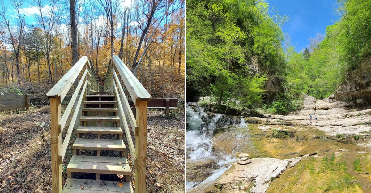
At the far end of the descent, where Turkey Creek meets the base of the amphitheater walls, a waterfall drops against a massive rock face. The combination of moving water and vertical limestone makes this the visual centerpiece of the entire hike, and it is the destination that most hikers are pushing toward from the moment they leave the trailhead.
The water in Turkey Creek runs a distinctive blue-green color in clear conditions, and the pool at the base of the falls reflects the surrounding rock walls in a way that makes the scale of the formation easier to appreciate. The area around the falls is wide enough to sit, rest, and take in the surroundings before the return climb begins.
Not every visitor finds the waterfall on a first attempt, particularly those who veer off-route before reaching the basin. Staying on the main marked trail and continuing past the second tree bridge is the most reliable way to reach the falls without an unplanned detour.
The Two Tree Bridges: A Trail Feature Worth Noting

Two tree bridges cross Turkey Creek along the main trail route, and both are legitimate landmarks worth tracking as navigation checkpoints. The bridges mark progress along the trail and signal that the waterfall and amphitheater are within reach for hikers who have been counting steps since the trailhead.
After the second bridge, the trail passes near a cemetery, and this is a spot where route-finding requires attention. The correct path follows along the outside of the cemetery fence rather than the route that drops down into the creek bed.
Taking the wrong fork here adds unnecessary distance and confusion to an already demanding hike.
The bridges themselves are simple log and plank constructions that blend into the forest setting. They hold up well enough for foot traffic but are worth crossing carefully after heavy rainfall when the creek runs higher and the wood can be slick.
Trekking poles add stability at both crossings and on the rocky descent sections surrounding them.
Camping Options: Staying Overnight Near the Trailhead

Overnight options exist near the Walls of Jericho, though the details require some sorting out before you pack a tent. The Tennessee trailhead itself is posted with no-camping signs, and the sign stand in the parking area makes that clear to anyone who gets close enough to read it.
A primitive campground sits a short distance up the road on the Tennessee side, but it is designated for use by hunters during hunting season, which limits its availability for hikers depending on the time of year. The campground is well-located and has been described as a genuinely nice facility, making the seasonal restriction a notable frustration for backpackers.
The Alabama side of the trailhead offers primitive camping spaces that are open to hikers, and the facilities there are better maintained overall. For anyone planning a multi-night trip into the Walls of Jericho, starting from the Alabama parking area and setting up camp there is the more practical and straightforward approach compared to navigating the Tennessee side restrictions.
Seasonal Considerations: When to Visit and What Changes

Fall brings vivid foliage to the hillsides surrounding the Walls of Jericho, and the colors along the descent trail are genuinely striking during peak leaf season. The tradeoff is that fallen leaves cover the rocky trail surface and hide the roots and uneven ground underneath, adding a layer of difficulty to an already technical path.
Winter hiking on this trail has a practical advantage beyond the obvious cold-weather considerations. The red trail markers on the loop section are easier to spot when the trees are bare, and the reduced undergrowth along the Tennessee descent makes the path easier to follow than it is during summer months when overgrowth crowds the trail.
Spring and summer bring bugs, stinging nettle, and poison ivy to full strength along the Tennessee side, which is worth factoring into clothing choices. The creek runs higher and faster in spring, which affects the crossings and adds to the overall difficulty.
Each season presents a different version of the same trail, and none of them is entirely without challenge.
Wildlife and Natural Features Along the Route

The terrain along the Walls of Jericho trail supports a diverse range of natural features beyond the main amphitheater. Caves appear throughout the hillsides, particularly along the loop trail section, and the limestone geology that created the main bowl is responsible for the cave formations scattered across the broader landscape.
The forest cover along the trail shifts in character as the elevation drops, moving from the mixed hardwood typical of the Cumberland Plateau into the more sheltered ecosystem of the creek valley below. The change in plant life between the ridgeline and the basin floor is noticeable even to hikers who are not actively looking for it.
The area sits within a large Wildlife Management Area, which means hunting activity is part of the land use calendar and worth checking before visiting during fall months. The remote nature of the trail and the limited foot traffic on the loop section means wildlife encounters are possible, and the general seclusion of the back half of the route adds to that likelihood.
The Loop vs. Out-and-Back: Choosing Your Route

Two main route options exist at the Walls of Jericho, and the choice between them significantly affects the difficulty and navigational complexity of the day. The out-and-back route follows the main trail down to the falls and returns the same way, covering roughly 6.7 miles with clear markers and reliable foot traffic to keep the path obvious.
The full loop adds considerable distance and takes hikers through the back section of the trail network, where maintenance is inconsistent and the markers are far less reliable. The loop has been estimated at anywhere from 9 to 10 miles depending on GPS tracking, and the elevation and navigation challenges make it a meaningful step up in difficulty from the out-and-back option.
First-time visitors are consistently better served by the out-and-back route. The loop rewards experienced hikers who are comfortable with off-trail navigation and have the gear and time buffer to handle an extended route.
Going in with a clear plan and a backup navigation method is the baseline requirement for the loop.
Safety on the Trail: What the Route Demands

The Walls of Jericho trail is remote enough that basic safety preparation matters more here than on a typical day hike close to a populated area. Cell signal is unreliable throughout much of the route, and there are stretches where the phone drops signal entirely, which removes real-time GPS and emergency communication as fallback options.
Telling someone where you are going and when you expect to return is a simple step that carries real weight on a trail this isolated. The Tennessee side in particular sees less foot traffic than the Alabama approach, which means help is not necessarily close by if something goes wrong in the back half of the route.
Ankle injuries are among the most common problems on rocky, root-heavy trails like this one, and the combination of steep descent and uneven footing creates consistent opportunities for a misstep. Bringing a basic first aid kit, knowing the general direction of the trailhead from any point on the route, and pacing yourself on the descent all contribute to a safer overall experience.
Why This Trail Keeps Drawing Hikers Back

The Walls of Jericho has a reputation that extends well beyond Franklin County, Tennessee, and the steady stream of hikers making the drive to Belvidere reflects that. The combination of a genuine geological spectacle, a physically demanding route, and a remote setting that filters out casual visitors gives the trail a character that is hard to replicate elsewhere in the region.
The trail is not easy, and it does not pretend to be. The rocky descent, the overgrown sections, the unreliable markers, and the long climb back out all require real effort and preparation.
That difficulty is part of what makes reaching the amphitheater feel worthwhile rather than incidental.
The Walls of Jericho is managed in part through conservation efforts by The Nature Conservancy, which has worked to protect the land on both sides of the state line. The trail connects hikers to one of the more geologically significant natural features in the southeastern United States, and that alone gives it a standing that outlasts any individual visit or single season on the trail.
Where the Trail Begins: Location and Access

The Tennessee trailhead for the Walls of Jericho sits along Rowe Gap Rd in Belvidere, TN 37306, a small rural community tucked into Franklin County near the Alabama state line. Getting there requires navigating winding country roads, so a downloaded offline map is strongly recommended before you leave cell range.
The trailhead itself is open 24 hours a day, seven days a week, which gives hikers flexibility on timing. A gravel parking area marks the starting point on the Tennessee side, and a sign stand near the lot provides basic trail information, though the sign has seen better days.
The Alabama trailhead, a short drive across the state line, is generally considered better maintained and offers primitive camping spots. Many hikers choose to park on the Alabama side for that reason.
Whichever side you start from, arriving early in the morning gives you the best chance of a quieter, less crowded experience on the trail.


