There is a railway in Chattanooga, Tennessee, that does something most trains would never attempt. It climbs straight up the side of a mountain at a grade so steep that the cars tilt noticeably as they ascend.
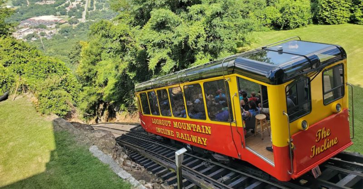
It has been hauling passengers up that dramatic slope since 1895, making it one of the most remarkable pieces of engineering in the American South. At its steepest point, the track hits a 72.7% grade, which is widely recognized as the steepest passenger railway in the world.
Beyond the railway itself, Lookout Mountain is packed with history, natural wonders, and outdoor adventures that make it a destination worth every bit of the climb. This article covers everything you need to know before you go, from the railway mechanics to the best trails, the Civil War past, and the underground waterfall waiting at the end of the line.
The Incline Railway and Its Record-Breaking Grade

A 72.7% grade means that for every 100 feet of horizontal distance, the track rises 72.7 feet vertically. That number is not just impressive on paper; it is genuinely striking when you are sitting inside the car and watching the ground tilt away beneath you.
The Lookout Mountain Incline Railway has held the title of the world’s steepest passenger railway for well over a century, and it still operates today as a working transit line, not just a tourist novelty.
The railway opened in 1895 and uses a counterbalance system, meaning two cars run simultaneously on parallel tracks, with one going up as the other descends, each helping to offset the other’s weight.
The cars are built with stepped, tiered seating so passengers remain relatively level even as the car climbs the steep incline. The ride takes about eight to ten minutes each way.
It remains one of the most iconic ways to arrive at the top of Lookout Mountain.
How the Counterbalance System Actually Works

The engineering behind the Incline Railway is worth understanding before you ride it, because it makes the experience more interesting once you are on board.
Two cars run on parallel tracks, connected by a single continuous cable that loops around a large bullwheel at the top station. As one car descends, its weight helps pull the other car upward, reducing the amount of energy the motor needs to supply.
This counterbalance system is not unique to Lookout Mountain, but the extreme grade here makes it especially critical. The cable itself is thick steel wire rope, regularly inspected and replaced on a maintenance schedule.
Braking systems are built into both the cars and the track, providing multiple layers of redundancy. The cars also have automatic grips that lock onto the track if tension in the cable drops unexpectedly.
The whole system has been running reliably for over 125 years, which is a testament to both the original design and the ongoing maintenance program that keeps it operating safely.
The Civil War History Written Into This Mountain

Lookout Mountain was not always a tourist destination. During the Civil War, it was a battlefield, and the scars of that history are still visible across the ridge.
The Battle Above the Clouds took place here in November 1863, when Union forces under General Joseph Hooker drove Confederate troops off the mountain in a fog-shrouded engagement that became one of the more dramatic moments of the Chattanooga Campaign.
Point Park, managed by the National Park Service as part of Chickamauga and Chattanooga National Military Park, sits at the northern tip of the mountain’s brow and marks the spot where much of the fighting took place.
The park contains monuments, historic cannons, and interpretive markers that walk visitors through the sequence of events during those November days.
The Battles for Chattanooga Museum nearby adds additional context with electric maps and artifacts that make the campaign easier to follow.
The mountain’s role in the war explains why it became famous long before the railway or the tourist attractions arrived.
Ruby Falls: The Underground Waterfall Below the Ridge

Buried more than 1,100 feet underground inside Lookout Mountain is a 145-foot waterfall called Ruby Falls, and it is one of the most unusual natural attractions in the entire southeastern United States.
The waterfall was discovered in 1928 by Leo Lambert, a local cave enthusiast who was drilling an elevator shaft to access a previously known cave. During the drilling, he broke through into an entirely unknown cavern system and eventually found the waterfall at its end.
He named it after his wife, Ruby.
Tours descend by elevator into the mountain and then walk through the cavern along a lit pathway before reaching the falls chamber, where the water drops from the ceiling into a pool below.
The cave itself features the usual formations found in limestone caverns, including stalactites, stalagmites, and columns built up over thousands of years.
Ruby Falls has been open to the public since 1930, making it one of the longest-running cave attractions in the country and a fixture of Lookout Mountain tourism for nearly a century.
Rock City and the Gardens on the Brow

Rock City Gardens sits on the brow of Lookout Mountain and has been drawing visitors since Garnet Carter opened it to the public in 1932. The attraction is built around a series of massive sandstone rock formations, narrow passages, and garden plantings that wind along the edge of the ridge.
The famous marketing campaign that painted “See Rock City” on barn roofs across the South made it one of the most recognized roadside attractions in American history. At its peak, over 900 barns carried the message across 19 states.
The walking trail through the gardens covers about a half mile and passes through tight rock crevices, across suspension bridges, and to a lookout point called Lover’s Leap where, on a clear day, seven states are reportedly visible.
The gardens are particularly popular in spring when the wildflowers and native plantings are at their peak, and in fall when the surrounding forest changes color.
Rock City has remained in continuous operation for over 90 years, which places it among the most enduring roadside attractions in the country.
Hiking Trails That Reward the Effort

The trail network on and around Lookout Mountain offers options for hikers at different fitness levels, and several routes lead to overlooks that put the scale of the ridge and the valley into clear perspective.
Sunset Rock is one of the most popular destinations, a sandstone outcrop on the western face of the mountain that sits just off the main trail and provides a broad view of the Tennessee River bend and the Chattanooga skyline.
The trail to Sunset Rock is part of the Lookout Mountain Trail, which connects several key points along the brow and can be combined with the Point Park loop for a longer outing.
The Bluff Trail runs along the base of the mountain’s cliff face and connects several access points in the St. Elmo neighborhood below, offering a different perspective on the ridge.
Most of the trails here are well-marked and maintained, though some sections involve uneven rock surfaces that call for sturdy footwear.
The views from the brow trails on a clear afternoon make the effort completely worthwhile.
The St. Elmo Neighborhood at the Mountain’s Base

At the foot of Lookout Mountain sits St. Elmo, one of Chattanooga’s oldest and most architecturally intact neighborhoods. The lower station of the Incline Railway anchors its main commercial block on St. Elmo Avenue, and the streets around it are lined with late 19th-century homes that have been carefully maintained.
The neighborhood developed largely because of the railway itself. When the Incline opened in 1895, it made the mountain accessible for daily commuters, and residential development followed quickly on both the mountain’s slopes and the flatland below.
Today, St. Elmo has a small collection of local cafes, eateries, and independent shops clustered near the railway station, making it a natural starting point for a day on the mountain.
The neighborhood has a walkable, unhurried character that contrasts with the busier tourist zones higher up on the ridge.
Parking near the lower station is generally easier to find than at the upper attractions, which makes St. Elmo a practical base for anyone planning to ride the railway up and explore on foot.
Practical Tips for Planning Your Visit

A well-planned visit to Lookout Mountain covers more ground and wastes less time, especially since the major attractions are spread across different parts of the ridge and require separate tickets.
The Incline Railway, Rock City, and Ruby Falls are each independently operated and priced. Combination tickets are sometimes available through Chattanooga tourism packages, so checking ahead can save money if you plan to visit more than one.
The railway runs daily but hours vary by season, and it is worth confirming current operating times before building your itinerary around it.
Parking at the upper station and near Rock City fills up quickly on weekends and holidays, particularly in summer and during fall foliage season. Arriving early or riding the railway from the St. Elmo lower station sidesteps most of the parking headaches.
Point Park and the National Park Service trails are free to enter, which makes them an easy addition to any itinerary.
Comfortable walking shoes are a practical necessity given the uneven terrain across most of the mountain’s trails and rock garden paths.
Where Lookout Mountain Sits on the Map

Lookout Mountain straddles the Tennessee-Georgia state line, but the bulk of its most famous attractions sit firmly on the Tennessee side, just minutes from downtown Chattanooga.
The Incline Railway’s upper station is located at 827 East Brow Road, Lookout Mountain, Tennessee 37350, perched right at the mountain’s ridge with sweeping views of the valley below.
The mountain rises about 2,100 feet above sea level and towers over the city of Chattanooga, which sits in the valley of the Tennessee River.
Getting here is straightforward. Most travelers drive up the winding St. Elmo Avenue from the base neighborhood of St. Elmo, or they ride the Incline Railway from its lower station on St. Elmo Avenue.
The mountain is part of the Cumberland Plateau and sits at the southwestern tip of the Appalachian range. Its position made it a strategic military point during the Civil War, a fact that still shapes how people understand and visit it today.


