There is a trail in Tennessee that has earned a reputation for being one of the most rewarding hikes in the entire state, and it ends at a waterfall that makes every steep climb and rocky scramble completely worth it. This trail runs through the rugged terrain of the Cumberland Plateau, cutting through forested gorges and past dramatic rock formations before delivering hikers to the base of Foster Falls, a 60-foot cascade that drops into a clear pool below.
The trail is not a casual stroll. At 12.5 miles, it challenges even experienced hikers with elevation changes, creek crossings, and technical terrain.
But that challenge is exactly what draws people back year after year.
The Fiery Gizzard Name: A Story Worth Knowing

One of the first questions most people ask about this trail is where on earth the name came from. The story most commonly told involves Davy Crockett, the legendary frontiersman who reportedly camped near the creek running through this gorge.
According to local lore, Crockett burned his tongue on a piece of wild turkey gizzard he was cooking over a campfire near the creek. He reportedly declared it a “fiery gizzard,” and the name stuck to the waterway and eventually the trail itself.
Whether or not the Davy Crockett story is entirely accurate, it has become a beloved part of the trail’s identity. The creek called Fiery Gizzard Creek does run through the gorge, and its name appears on official maps of the region.
The quirky origin story adds character to an already memorable hiking experience and gives hikers something fun to share when they get back home.
Trail Difficulty: What Hikers Actually Face

The Fiery Gizzard Trail is consistently rated as one of the more challenging hikes in Tennessee, and that rating is well-earned. Over its 12.5-mile length, the trail gains and loses significant elevation, crosses multiple creek sections, and moves through terrain that requires careful footing throughout.
Rocky outcroppings, narrow ridge walks, and root-covered paths keep hikers alert from start to finish. There are no paved or groomed sections.
The trail is natural and rugged, which is a large part of its appeal for those who prefer genuine backcountry conditions over manicured park paths.
Physical fitness matters here. Hikers who are new to long-distance trails or who are not comfortable with uneven terrain should prepare carefully before attempting the full route.
Trekking poles are widely recommended, and proper footwear makes a noticeable difference. The reward at the end, however, makes the effort feel like the most logical trade anyone could make.
The Gorge: Dramatic Landscape Along the Way

Much of the Fiery Gizzard Trail moves through a deep gorge carved by Fiery Gizzard Creek over thousands of years. The gorge walls rise steeply on either side, with sandstone bluffs and layered rock faces that give the landscape a distinctly ancient character.
The creek itself runs alongside sections of the trail, and hikers will cross it multiple times depending on conditions and the specific route taken. During wetter months, these crossings can be challenging, and water levels should be checked before setting out.
The forest inside the gorge is dense with hemlock, oak, and rhododendron. The canopy overhead creates a shaded corridor that keeps temperatures cooler than surrounding areas, which makes the trail particularly appealing during warmer months.
The combination of moving water, towering rock walls, and thick forest gives the gorge a raw, untouched quality that is increasingly rare in accessible public lands across the region.
Waterfalls Along the Route Before Foster Falls

Foster Falls may be the grand finale, but it is far from the only waterfall on the Fiery Gizzard Trail. Several smaller cascades and plunge pools appear along the route, rewarding hikers who pay attention and take their time moving through the gorge.
Blue Hole Falls is one of the most popular intermediate stops. It sits along Fiery Gizzard Creek and drops into a clear pool that has become a well-known swimming spot during summer months.
The falls are accessible relatively early in the hike from the Grundy Forest trailhead, making them a worthwhile destination even for those who do not plan to complete the full route.
Other unnamed cascades appear throughout the gorge depending on recent rainfall. After heavy rain, the entire gorge comes alive with water moving over rocks and ledges in ways that change the trail experience entirely.
Each waterfall adds a new reason to pause and take in the surroundings before moving on.
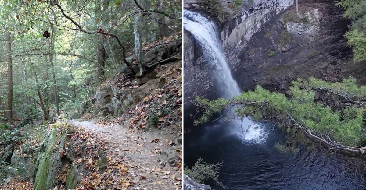
Foster Falls: The 60-Foot Payoff at Trail’s End

Foster Falls is the destination that gives the Fiery Gizzard Trail its reputation as a must-do hike in Tennessee. The falls drop approximately 60 feet over a wide sandstone ledge into a pool below, creating one of the most visually striking natural features on the entire Cumberland Plateau.
The volume of water coming over the falls varies by season. Spring and early summer typically bring the heaviest flow, when snowmelt and rain combine to push large amounts of water over the ledge.
By late summer, the flow slows considerably, but the falls remain impressive even at lower levels.
The pool at the base of Foster Falls is a popular swimming destination during warmer months. A short spur trail from the Foster Falls parking area allows day visitors to reach the falls without completing the full 12.5-mile route.
That means even casual hikers can experience the waterfall, though arriving from the trail after the full journey adds a completely different level of satisfaction.
Wildlife and Natural Features Worth Watching For

The Fiery Gizzard Trail passes through a remarkably biodiverse stretch of the Cumberland Plateau, and wildlife encounters are a regular part of the experience. White-tailed deer, wild turkey, and various songbirds are commonly spotted along the route, particularly in the early morning hours.
The gorge environment supports species that prefer cool, moist conditions. Box turtles, salamanders, and various amphibians can be found near creek crossings and wet rock faces.
Birders will find the trail particularly rewarding, as the forest layers support everything from warblers to woodpeckers throughout the year.
Wildflowers appear in significant numbers during spring, with trillium, wild geranium, and hepatica blooming along the trail corridor. The rhododendron thickets that line much of the gorge produce showy blooms in late spring and early summer, turning sections of the trail into a corridor of color.
Paying attention to the smaller details along the trail turns a physical challenge into a full natural history experience.
Camping Options Along the Trail

The Fiery Gizzard Trail offers backcountry camping opportunities that allow hikers to extend their trip into a multi-day adventure. Designated backcountry campsites are located along the trail corridor, and a free permit is required to use them.
Permits can be obtained through South Cumberland State Park.
The camping experience along this trail is genuinely rustic. There are no electrical hookups, no running water at campsites, and no maintained facilities beyond basic designated areas.
Hikers need to carry all water filtration equipment, food, and shelter. The remote nature of the camping adds to the appeal for those who prefer a true backcountry experience.
Campfires may be restricted depending on conditions and season, so checking current rules before heading out is always a good idea. The sounds of Fiery Gizzard Creek running nearby make the camping experience particularly atmospheric, and waking up inside the gorge before other day hikers arrive gives campers an unmatched perspective on the trail.
Best Times of Year to Hike Fiery Gizzard

Timing a hike on the Fiery Gizzard Trail can make a significant difference in the overall experience. Each season brings its own advantages and challenges, and understanding those differences helps hikers plan accordingly.
Spring is widely considered the best time for waterfall volume. Rain and cooler temperatures keep the creek running strong, and wildflowers add color throughout the gorge.
Fall brings spectacular foliage to the plateau, and the cooler temperatures make the physical demands of the trail more manageable. Many experienced hikers consider October and November the ideal window for the full 12.5-mile route.
Summer hiking is possible but comes with heat and humidity that can make the trail more taxing than expected. The shaded gorge helps, but hikers should start early and carry plenty of water.
Winter hiking attracts a smaller crowd and can produce dramatic frozen waterfall formations, though trail conditions become more technical. Each season offers a genuinely different version of the same trail.
The Trail’s Connection to South Cumberland State Park

The Fiery Gizzard Trail is part of the larger South Cumberland State Park system, which covers over 25,000 acres across multiple counties in Tennessee. The park is one of the largest in the state and contains a network of trails, natural areas, and visitor facilities spread across a wide section of the Cumberland Plateau.
The park’s visitor center, located in Monteagle, Tennessee, serves as a central hub for information about all of the park’s units, including the Grundy Forest and Foster Falls areas. Staff there can provide current trail conditions, permit information, and maps that help hikers plan their route effectively.
South Cumberland State Park was developed through a combination of state land acquisitions and conservation efforts over several decades. The Fiery Gizzard Trail is considered the crown jewel of the park’s trail system, and it regularly draws hikers from across the southeastern United States.
Its inclusion in the park system ensures ongoing protection for the gorge and its surrounding natural landscape.
Why This Trail Keeps Pulling Hikers Back

There are plenty of trails in Tennessee that offer a good workout or a nice view, but the Fiery Gizzard Trail delivers something that is harder to find: a complete experience from start to finish. The combination of gorge terrain, multiple waterfalls, wildlife, and a genuinely impressive endpoint creates a hike that feels different every time it is attempted.
Conditions change with the seasons, water levels shift the creek crossings, and the light inside the gorge transforms the rock walls and forest canopy throughout the day. No two trips feel exactly alike, which is a rare quality in a trail that is as well-documented and frequently hiked as this one.
The Fiery Gizzard Trail rewards the effort put into it. Whether someone completes the full 12.5 miles point-to-point or hikes just to Blue Hole Falls and back, the trail offers something worth the drive to Tracy City.
Foster Falls at the end is just the exclamation point on a trail that earns its reputation every single time.
Where the Trail Begins: Location and Access

The Fiery Gizzard Trail is located within South Cumberland State Park in Tennessee, with the main trailhead situated near the Grundy Forest Day Use Area in Tracy City, Tennessee. The address for the Grundy Forest trailhead is 176 Fiery Gizzard Rd, Tracy City, TN 37387.
Getting there is straightforward from Interstate 24. Travelers exit toward Tracy City and follow signs for South Cumberland State Park.
The parking area at Grundy Forest is well-maintained and free to use, with restroom facilities available near the trailhead.
The trail runs point-to-point, meaning it starts at Grundy Forest and ends at Foster Falls Small Wild Area, which is located about 12.5 miles away. Most hikers arrange a car shuttle between the two trailheads or plan a full out-and-back trip.
The Foster Falls end also has its own parking lot, making logistics manageable for groups with two vehicles.


