A sudden tornado struck Purcell, Oklahoma, as severe storms roared across the Plains, catching many by surprise. Radar lit up with intense rotation while phones buzzed with urgent alerts, pushing everyone to seek shelter fast. You could feel the tension in the air as wind, hail, and lightning piled on the danger. Keep reading to understand what happened, why it escalated so quickly, and how to stay safe as the threat continues.
Tornado Strikes Purcell, Oklahoma as Severe Storms Sweep the Plains
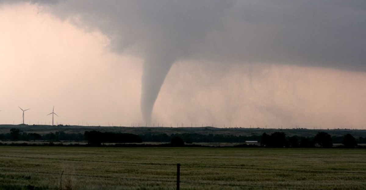
A confirmed tornado touched down in Purcell, Oklahoma, as a fast-moving line of severe storms swept the Southern Plains. You could hear sirens wail and see flashes on the horizon as winds ramped up fast. Fox Weather reported the tornado formed amid unstable air, strong wind shear, and an accelerating storm system.
Emergency officials described damage to buildings and infrastructure south of Oklahoma City, including shattered windows and peeled roofs. Tornado warnings arrived with little lead time, a common reality when Plains storms spin up quickly. Early alerts likely helped people reach interior rooms and basements, preventing injuries or worse.
Meteorologists said the twister developed rapidly as storms intensified and briefly organized, a hallmark of spring-like setups even outside peak season. While surveys continue, preliminary reports show scattered structural damage and power outages. You could feel how fast conditions changed from rumbling thunder to life-threatening within minutes.
This tornado was part of a broader outbreak affecting Oklahoma and neighboring states, underscoring the need to act at the first alert. Keep helmets, shoes, and chargers ready during active weather. Quick decisions and trusted warnings make all the difference when seconds matter.
Powerful Storm Environment Fueled Tornado Development
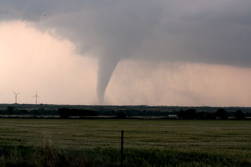
Forecasters explained the Purcell tornado formed where rich Gulf moisture surged north beneath strong low-level wind shear. That shear helped storms rotate, especially as a dryline and cold front sharpened lift. You could see storms explode quickly, with towers tilting and spinning as they tapped buoyant air.
Fox Weather meteorologists noted discrete cells evolved into supercells, the rotating storms most prone to tornadoes. Radar showed a tight velocity couplet before touchdown, signaling a strengthening mesocyclone. Along with the tornado, damaging straight-line winds, large hail, and intense lightning added overlapping hazards.
Gusts strong enough to down trees and power lines were reported across multiple counties. Hail cores marched east, dinging vehicles and punching holes in siding. You could watch the inflow tails feed rotation, a textbook sign the storm environment was primed.
Experts emphasized that transitional seasons keep the Plains vulnerable as warm and cold air masses collide. Even on marginal outlook days, localized ingredients can spike risk fast. Keep a close eye on surface boundaries, dew points, and low-level jet timing to anticipate sudden upgrades and act before warnings arrive.
Emergency Response and Safety Measures Activated
Local emergency managers and first responders mobilized quickly after the tornado report. Crews began door-to-door checks, cleared debris from intersections, and coordinated utility shutoffs around downed lines. You could hear chainsaws and see flashing lights as teams pushed to reopen critical routes.
Officials urged residents to avoid damaged areas and let emergency vehicles through. Some roads closed temporarily while structural assessments proceeded and hazards were flagged. Multiple ways to receive alerts proved crucial, including NOAA Weather Radio, smartphone notifications, and local media updates.
Authorities reminded everyone to refresh tornado plans: identify an interior room or basement, wear sturdy shoes, and keep helmets and chargers handy. Pets need carriers ready and leashes near shelter spots. You should also store copies of IDs and medications in a grab bag for quick exits.
Community shelters opened for those with damaged homes or extended outages. Volunteers assisted with welfare checks and distributed tarps, water, and flashlights. After the all-clear, treat intersections with dark signals as four-way stops, and photograph damage for insurance once it is safe. Preparedness pays off long before sirens start.
Severe Weather Threat Continues Across the Plains
Meteorologists warned the same system could keep producing severe storms as it moves east. Conditions remain favorable for additional tornadoes, damaging winds, and hail across parts of Oklahoma and neighboring states. You should stay alert for rapid changes and treat each warning like it is the one that matters.
Fox Weather highlighted multi-day potential, meaning threats can persist even after an initial round passes. Nighttime tornadoes pose extra risk due to poor visibility and slower response. Keep phones charged, volume on, and a weather radio nearby in case power or cell service drops.
Do not wait to see a funnel before sheltering. If a warning triggers, move to a basement or small interior room on the lowest floor, away from windows. Wear shoes, grab helmets, and cover your head with pillows or a mattress.
As the front advances, watch for quick-hitting spin-ups along bows and embedded supercells. Remember that severe hazards often extend far from the core of a storm. Stay weather aware through the evening and overnight, and reassess plans each day until the pattern breaks.


