A fast-forming coastal storm is lining up to sweep from the Carolinas to New England this weekend, bringing a volatile mix of heavy snow, fierce winds, and coastal flooding. Timing will be everything, and small track shifts could dramatically change what you see out your window.
Use this hour-by-hour outlook to plan travel, prep your home, and avoid the worst impacts. Stay flexible, because this storm could strengthen quickly and surprise unprepared communities.
Friday evening brings the opening act as a broad shield of light snow blossoms from the Tennessee Valley into the Appalachians and portions of Virginia. You might notice flurries coating cooler surfaces first, while roads stay merely wet before temperatures dip.
This is the appetizer, not the main course, but it can still catch drivers off guard and slick up bridges and overpasses after sunset.
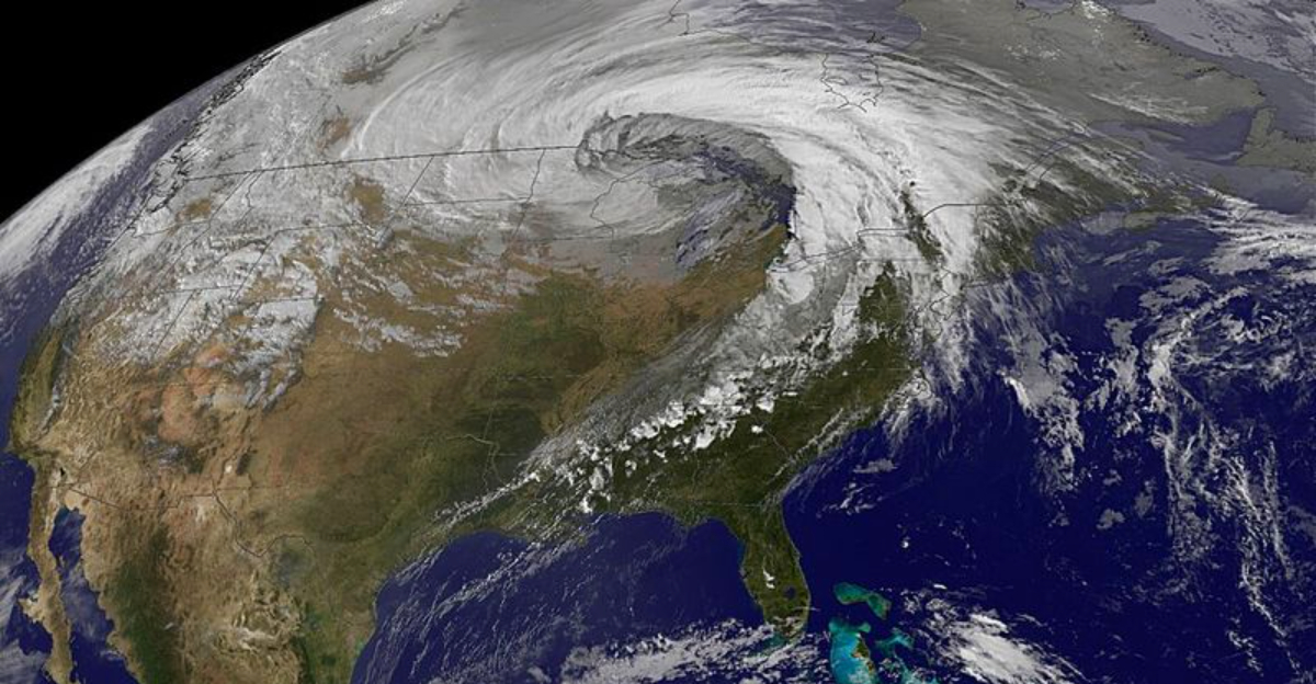
As the night wears on, a developing low off the Southeast coast begins to tighten. You will hear forecasters talk about pressure falls and strengthening fronts feeding the coastal wave.
That means moisture is organizing and starting to pivot inland, with bands gradually consolidating from west to east as the steering flow turns more northeasterly.
Expect the snow to stay mostly light and intermittent through late Friday, with localized moderate bursts near the Blue Ridge. If you have errands, finish them early and clear outdoor drains before temperatures slide.
By pre-dawn Saturday, signals of a sharper uptick appear on radar, and the stage is set for rapid intensification as the nascent nor’easter grabs Atlantic energy.
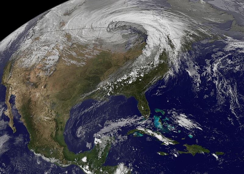
Saturday is the teeth of the storm. As colder air pours in, moisture deepens and mesoscale bands ignite, delivering hour-after-hour snowfall that stacks up fast.
Interior Carolinas and central Virginia are favored for 8 to 12 inches if banding stalls, with cities like Raleigh, Richmond, and Charlotte seeing sustained snow and sharply reduced visibility.
This is when bombogenesis is most likely, with a steep pressure drop tightening the gradient. Winds accelerate, gusting 40 to 60 mph inland and higher along exposed coasts.
Near the Outer Banks, gusts pushing 60 to 70 mph can produce blizzard-like conditions, blowing and drifting snow, and sporadic coastal overwash.
Travel will deteriorate quickly. Expect jackknifed trucks, spinouts, and closures as salt loses effectiveness in heavier bursts.
Have a go-bag ready: flashlight, batteries, layered clothing, snacks, and charged power banks. If you must drive, stick to main routes, slow down, and keep extra distance, because whiteouts can drop in without warning.
By Sunday, the storm slides north, easing snow across the Carolinas and Virginia while sharpening its focus on southeast Massachusetts and broader New England. If the track hugs the shore, coastal communities face heavier totals and stronger winds.
A slight offshore jog would shift the bullseye seaward, but gusts still ripple inland along I-95.
Plan for intermittent whiteouts in heavier bursts from Rhode Island to coastal Maine, with plowable snow likely near the South Shore and Cape Ann. High tides plus persistent onshore flow elevate the risk for minor to moderate coastal flooding and beach erosion.
Marine conditions will be dangerous with steep waves and building swell.
Inland metro zones like New York City and Boston could toggle between light snow and breaks, yet travel remains slow from drifting and refreeze. Watch for power flickers as tree limbs glaze and winds rattle weakened branches.
Keep devices charged, avoid flooded roadways, and give plows room, because cleanup will lag where the wind keeps redepositing snow onto treated surfaces.
Once the core departs late Sunday or early Monday, the pattern flips to crisp and punishing cold. Arctic air pours in behind the low, and wind chills bite, especially inland.
That means anything untreated will refreeze overnight, keeping black ice a stealth hazard long after the last flakes fly.
Expect slow commutes, popped water lines in poorly insulated spaces, and crunchy sidewalks that demand careful steps. South of the storm’s snow axis, places like Atlanta and Knoxville could still wrestle with lingering slick spots if accumulations materialized.
Schools and offices may delay openings to allow plows and salt crews to catch up.
Stay weather-aware: monitor advisories, conserve phone battery, and restock essentials like medications, pet supplies, and bottled water. Ventilate if you use space heaters, keep generators outdoors, and check on neighbors who might lose heat.
When shoveling, take breaks and push rather than lift to protect your back and heart, because cold air stresses the body more than you think.


