South America is a continent where nature and human history have been building something extraordinary for thousands of years. From mountains that touch the clouds to deserts that bloom with color after rain, the landscapes here are unlike anything else on Earth.
Ancient civilizations carved cities into cliffs, drew giant pictures in the sand, and raised stone giants on remote islands. The 12 places on this list prove that South America has always been a place where the impossible becomes real.
Machu Picchu, Peru
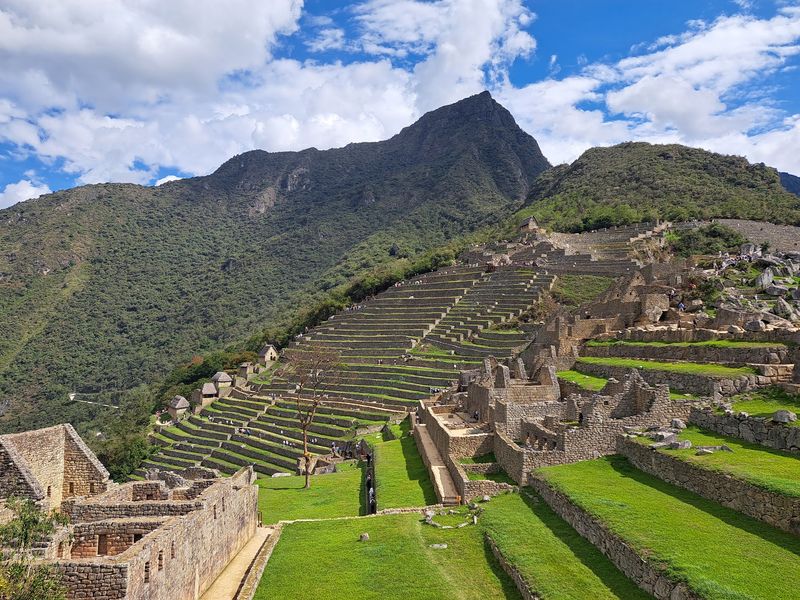
Perched at nearly 8,000 feet above sea level, Machu Picchu looks like it grew straight out of the mountain rather than being built on top of it. The Inca constructed this complex during the 15th century, fitting together hundreds of stone structures without a single drop of mortar.
Agricultural terraces, ceremonial temples, and residential quarters all share the same dramatic ridgeline, with the surrounding cloud forest dropping away on nearly every side.
UNESCO protects not just the citadel but over 32,000 hectares of surrounding mountains, valleys, and tropical forest. That protection recognizes how completely the Inca merged their architecture with the natural terrain, making Machu Picchu both a cultural and natural World Heritage site.
Builders also engineered underground drainage channels to prevent the steep slopes from collapsing under heavy rainfall.
Visitors regularly describe the first glimpse of the site as genuinely breathtaking, and that reaction makes complete sense. Few places on Earth manage to feel simultaneously ancient, precise, and totally wild.
Whether you approach by train through the Sacred Valley or trek the famous Inca Trail, the arrival never disappoints.
Iguazu Falls, Argentina and Brazil
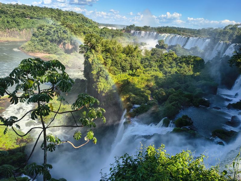
Standing at the edge of Iguazu Falls feels less like watching a waterfall and more like witnessing the river itself lose its mind. The Iguazu River drops up to 80 meters across nearly 2.7 kilometers of cascades, creating a wall of sound and mist that soaks visitors long before they reach the famous Devil’s Throat section.
Rainbows form and dissolve constantly in the spray, and the surrounding subtropical forest presses right up to the cliff edges.
Both Argentina and Brazil protect adjoining UNESCO World Heritage national parks around the falls. Together, these parks preserve a crucial remnant of the Parana subtropical forest, sheltering jaguars, tapirs, giant anteaters, ocelots, and hundreds of bird species.
The underlying landscape reflects ancient volcanic rock, while ongoing erosion keeps reshaping the riverbed and cliffs year after year.
Trails on both sides of the border reveal completely different perspectives. The Argentine side puts you right inside the cascade system on elevated walkways, while Brazil offers the sweeping panoramic view.
Honestly, visiting both countries gives you the full picture, and the border crossing between them is surprisingly easy to manage.
Galapagos Islands, Ecuador
Roughly 1,000 kilometers off Ecuador’s mainland, the Galapagos Islands decided to play by their own evolutionary rules. Three ocean currents converge around the archipelago, and ongoing volcanic and seismic activity keeps reshaping the islands themselves.
That combination of isolation and geological restlessness created conditions where life developed in directions found absolutely nowhere else on the planet.
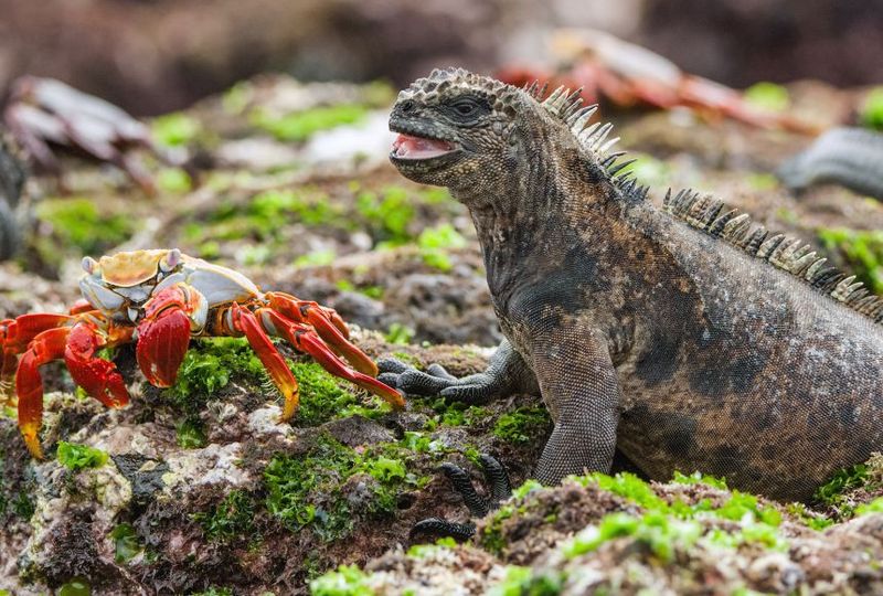
Giant tortoises wander at their own unhurried pace, marine iguanas sneeze salt from specialized glands, and Darwin’s finches have diversified into over a dozen distinct species. Charles Darwin visited in 1835, and his observations here later contributed directly to his theory of evolution by natural selection.
UNESCO calls the Galapagos a living museum and showcase of evolution, a description that genuinely earns its dramatic phrasing.
The protected property includes not just the islands but the surrounding marine environment, where cold and warm currents overlap to create an unusual mix of tropical, temperate, and deep-ocean ecosystems. Whale sharks, hammerhead sharks, sea lions, and penguins all share the same waters.
Visitor numbers are carefully controlled to protect the wildlife, so booking ahead is essential if you want to experience this place properly.
Nasca and Palpa Lines, Peru
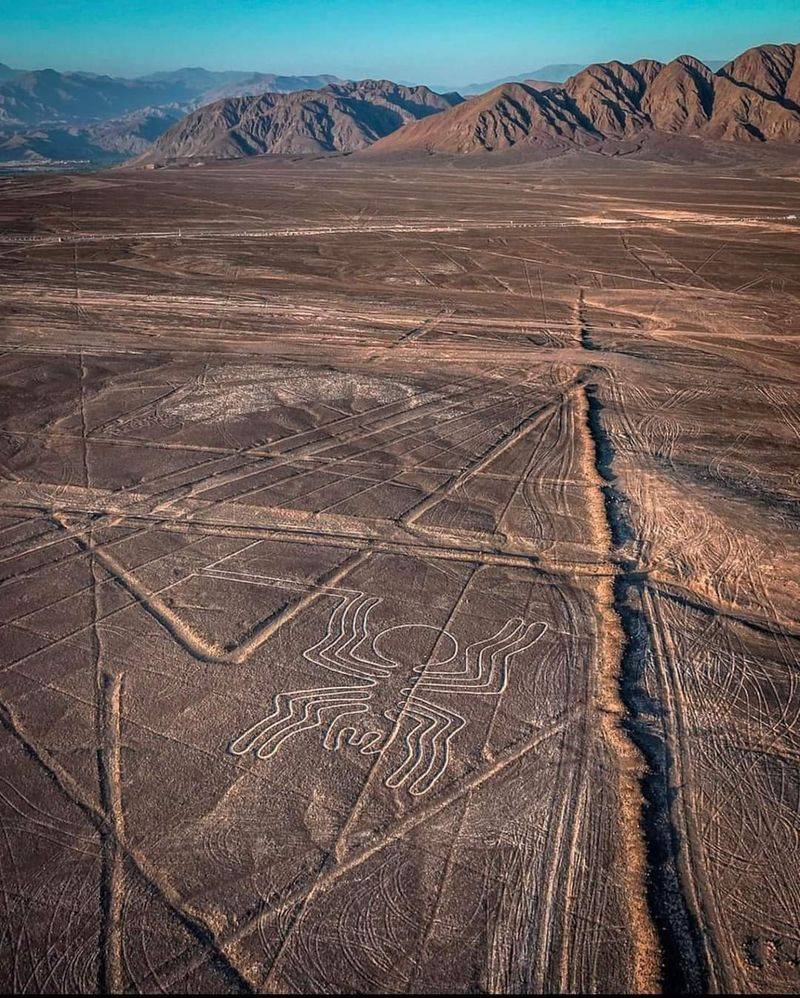
Imagine spending years drawing enormous pictures that only make sense when viewed from the sky. That is essentially what ancient peoples in southern Peru did, carving massive lines, animals, plants, and geometric shapes into the desert floor by removing dark surface stones to reveal lighter ground beneath.
The tradition developed over roughly 2,000 years, with major geoglyph creation occurring between about the 8th century B.C. and 8th century A.D.
The protected landscape covers more than 75,000 hectares, and the extreme dryness of the Nasca and Palpa region helped preserve these designs for centuries. Some geometric lines extend for several kilometers in perfectly straight paths, while figurative designs include a hummingbird, a condor, a spider, and a monkey.
UNESCO describes the landscape as strongly connected to ritual and religious traditions, though the exact meanings remain a subject of ongoing research.
Seeing the lines from a small aircraft is the classic experience, and the flights typically depart from Nasca or Pisco. Ground-level viewing platforms exist for some geometric figures near the main road.
The sheer scale of the designs, combined with how precisely they were executed without any aerial vantage point, remains one of archaeology’s most genuinely puzzling questions.
Rapa Nui National Park, Chile
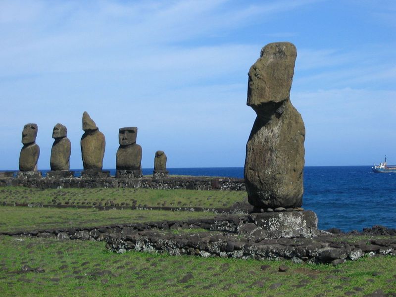
About 3,700 kilometers from continental Chile, Rapa Nui sits in the middle of the Pacific Ocean as one of the most isolated inhabited places on Earth. Polynesian settlers arrived and built a civilization that produced something genuinely unforgettable: roughly 900 enormous stone figures called moai, carved primarily between the 10th and 16th centuries.
Most were cut from volcanic tuff at a single quarry called Rano Raraku, directly connecting the monuments to the island’s geology.
Over 300 ceremonial platforms called ahu are scattered around the coastline, and many originally held multiple moai facing inland toward the communities they were meant to protect. The figures range from about 2 meters to over 10 meters tall, with the largest unfinished statue in the quarry measuring nearly 22 meters.
At Rano Kau volcano, the ceremonial settlement of Orongo preserves stone houses and extensive petroglyphs related to the later birdman tradition.
Getting to Rapa Nui requires a roughly five-hour flight from Santiago, and that journey alone gives you a sense of just how remote this place really is. Once there, the combination of volcanic craters, ocean cliffs, and silent stone giants creates an atmosphere that is difficult to describe and even harder to forget.
Canaima National Park, Venezuela
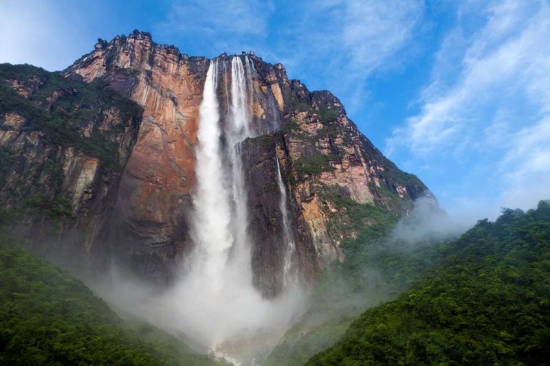
Canaima National Park is where the word “plateau” gets a serious upgrade. The park’s defining landforms are tepuis, enormous flat-topped mountains that rise abruptly from the surrounding jungle in southeastern Venezuela.
These ancient rock formations cover roughly 65 percent of a three-million-hectare park near the borders with Guyana and Brazil, and their sheer vertical cliffs have isolated the ecosystems on top for so long that many species exist nowhere else on Earth.
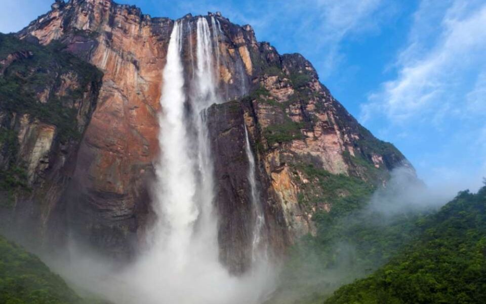
Water flowing off the high plateaus creates hundreds of waterfalls throughout the park, including Angel Falls, which drops approximately 1,000 meters and holds the title of the world’s highest waterfall. UNESCO inscribed Canaima as a World Heritage property in 1994, recognizing both the geological significance of the tepuis and their biological importance.
The park also includes the broad, lagoon-filled Canaima Lagoon area near the park’s western entrance, where several impressive falls empty directly into the water.
Reaching Angel Falls typically requires a small plane to the Canaima airstrip followed by a river journey by dugout canoe. The remoteness is part of the appeal, since the falls are surrounded by pristine jungle with no roads leading in.
Cloud cover can hide the upper section, so visiting during the wet season actually improves your chances of seeing the full drop.
Tiwanaku, Bolivia
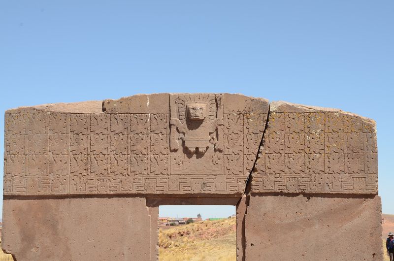
Building a major civilization at nearly 3,850 meters above sea level is not the obvious choice, but Tiwanaku’s founders apparently disagreed. This ancient city near Lake Titicaca flourished especially between about A.D. 400 and 900, developing into a carefully planned political and ceremonial center whose influence spread across broad areas of the central Andes.
The altitude alone would leave most modern visitors reaching for water and aspirin within an hour.
Surviving structures include the Akapana pyramid, the Kalasasaya temple, a semi-subterranean temple decorated with carved stone heads set into its walls, and the Pumapunku complex, where massive stone blocks were cut with extraordinary precision. Builders also created sophisticated underground drainage systems to manage water across the plateau, showing a level of engineering that matched the ceremonial ambitions of the site.
Agricultural terraces and raised field systems helped support farming despite the harsh climate.
Tiwanaku predates the rise of the Inca Empire by several centuries, making it one of the foundational civilizations of Andean prehistory. The famous Gateway of the Sun, carved from a single block of andesite stone, remains the site’s most iconic image.
Visiting alongside a guided tour helps decode the symbolism carved into these monuments, which can otherwise seem abstract without context.
Los Glaciares National Park, Argentina
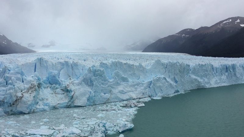
Few natural events in South America match the drama of watching a chunk of Perito Moreno Glacier the size of a building crash into Lake Argentino. This famous glacier advances slowly and sometimes blocks a channel of the lake, causing water levels to rise until the ice dam ruptures in a spectacular burst of sound and spray.
The glacier face reaches about 60 meters above the lake surface, making it one of the most accessible and visually striking ice walls on the planet.
Los Glaciares National Park covers more than 726,000 hectares in Argentine Patagonia, with dozens of glaciers flowing from the vast South Patagonian Ice Field. These moving rivers of ice have spent thousands of years excavating valleys, depositing moraines, and forming enormous lakes including Argentino and Viedma.
The landscape is still actively being shaped, which makes it feel genuinely alive in a way that older, more static landscapes do not.
Beyond the glacier, granite peaks including Cerro Fitz Roy rise more than 3,000 meters above the surrounding steppe, offering some of Patagonia’s most celebrated mountaineering and trekking terrain. The town of El Calafate serves as the main gateway, with regular flights connecting it to Buenos Aires.
Weather changes rapidly in this region, so packing layers regardless of the season is genuinely non-negotiable.
San Agustin Archaeological Park, Colombia
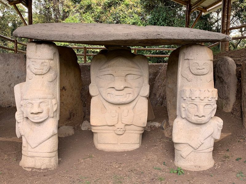
Hidden in the green mountains of southwestern Colombia, San Agustin holds South America’s largest concentration of religious monuments and megalithic sculpture, according to UNESCO. More than 600 statues are known across the wider Alto Magdalena region, with around one-third located within the World Heritage park itself.
These figures were created by societies that flourished in the northern Andes long before European contact, and their carved faces range from quietly human to genuinely fierce.
Burial mounds, stone tombs, ceremonial terraces, and statues depicting humans, gods, animals, and mythical creatures are scattered across a landscape of rolling hills and river valleys. The styles vary considerably, from realistic human proportions to highly abstract forms with exaggerated features.
One of the most unusual features anywhere in the park is Fuente de Lavapatas, a ceremonial sculpture carved directly into the rocky bed of a stream, channeling flowing water through carved serpents and faces.
San Agustin town serves as the practical base for exploring the park, and the area itself is genuinely beautiful highland Colombia countryside. The statues are spread across several separate mesitas, or flat-topped hills, so comfortable walking shoes and a full day are both recommended.
The combination of mystery, craftsmanship, and lush scenery makes this one of South America’s most underrated archaeological destinations.
Lencois Maranhenses National Park, Brazil
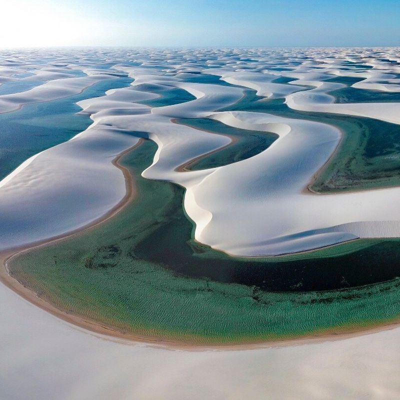
At first glance, Lencois Maranhenses looks like someone dropped a massive white desert right next to the Brazilian coast and forgot to tell the rain to stop. Prevailing winds push sand inland from roughly 80 kilometers of Maranhao coastline, building vast chains of crescent-shaped dunes that reach up to 30 meters high.
Then the rainy season arrives and fills the hollows between the dunes with freshwater lagoons in shades of turquoise, emerald, and deep blue, creating one of the most surreal landscapes in the entire Americas.
The UNESCO World Heritage property covers 156,562 hectares, including about 90,000 hectares of active dune fields. Some dunes migrate as much as 25 meters per year, meaning the landscape is genuinely never the same twice.
UNESCO added the park to the World Heritage List in 2024, recognizing it as South America’s largest field of shifting coastal dunes. The lagoons also support fish populations that somehow survive the dry season by burrowing into damp sand.
The town of Barreirinhas is the main access point, with 4×4 vehicle tours departing regularly for the dune fields. The best lagoon colors appear between July and September, after the rainy season has filled the hollows.
Walking barefoot across the warm white sand between lagoons is one of those simple travel experiences that somehow stays with you for years.
Chan Chan Archaeological Zone, Peru
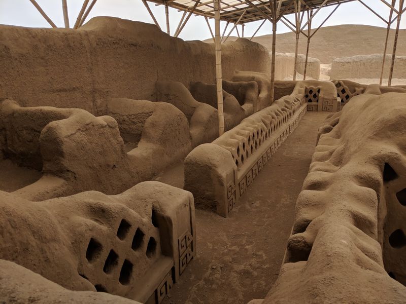
Before the Inca ever showed up, the Chimu were already running the largest earthen-architecture city in pre-Columbian America. Chan Chan sits on Peru’s arid northern coast near modern Trujillo, and at its peak in the 15th century it covered roughly 20 square kilometers of carefully organized urban space.
The city was divided into nine monumental compounds called ciudadelas, each functioning as a largely self-contained palace complex built for successive Chimu rulers.
Walls throughout the city are decorated with geometric patterns and relief carvings inspired by coastal marine life, including fish, seabirds, and sea otters. These decorations were applied to adobe surfaces using molds, creating repeating patterns that still impress visitors today despite centuries of erosion.
Canals and agricultural systems channeled water from distant rivers to sustain a large population in what is naturally one of Peru’s driest environments.
The Chimu Empire was eventually absorbed by the Inca around 1470, but Chan Chan’s scale demonstrates just how powerful this coastal civilization had become. UNESCO listed the site as a World Heritage property and placed it on the endangered list due to ongoing erosion from El Nino rainfall events.
The Tschudi compound is the most restored section and gives the clearest sense of how impressive the original city must have looked at full strength.
Torres del Paine National Park, Chile
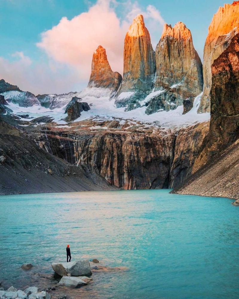
Torres del Paine makes a habit of stopping hikers mid-stride just to stare. The three granite towers that give the Chilean park its name are exposed remnants of intrusive rock that ancient glaciers gradually uncovered and sculpted into their current jagged profiles, rising dramatically above a landscape of turquoise lakes, windswept steppe, and Magellanic forest.
The park covers about 227,000 hectares and connects to the Southern Patagonian Ice Field, which feeds glaciers including the impressive Grey Glacier at the park’s western edge.
Guanacos graze the open steppe without much concern for passing trekkers, condors circle the thermal currents above the peaks, and pumas occasionally make appearances near the lakeshores at dawn. The W Trek and the longer O Circuit connect most of the park’s major landscapes, with refugios and campsites positioned along both routes.
Permits and accommodation book out months in advance during peak season, so planning early is genuinely essential rather than just good advice.
Patagonian weather is famously unpredictable, cycling through sun, rain, and fierce wind sometimes within the same afternoon. That volatility actually adds to the experience, since the light shifts constantly and every hour can produce a completely different view of the towers.
Chile’s tourism organization calls this combination of granite, ice, lakes, and steppe the defining wilderness of Chilean Patagonia, and it is hard to argue with that assessment.
Share this story