Some towns exist in places that seem almost impossible to live in. From the bottom of the Grand Canyon to the frozen edges of the Arctic, real communities have put down roots in landscapes most people only see in documentaries.
These are not ghost towns or abandoned experiments. They are living, breathing places with schools, shops, traditions, and neighbors who have figured out how to call some of Earth’s wildest geography home.
Edinburgh of the Seven Seas, Tristan da Cunha
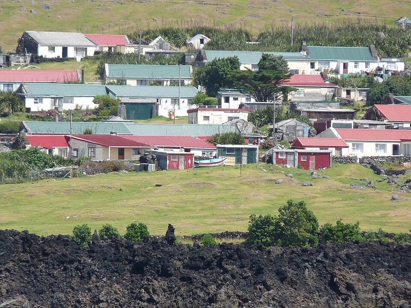
Imagine mailing a letter that takes weeks to arrive because the nearest post office is on another island 2,437 kilometers away. Edinburgh of the Seven Seas holds the record as the most isolated permanent settlement on Earth, sitting on the volcanic island of Tristan da Cunha in the middle of the South Atlantic.
Only about 222 people call it home.
There is no airport. Full stop.
Every visitor arrives by ship, and rough seas can actually prevent passengers from landing even after the long voyage is complete. The harbor, a school, a hospital, a supermarket, and even a cafe all operate beneath 800-meter cliffs that shoot straight up from the ocean.
The islanders are a tight-knit community with just a handful of family surnames shared among nearly everyone in town. They grow their own potatoes, fish the surrounding waters, and keep traditions alive that stretch back generations.
Life here runs on its own quiet rhythm, far removed from the noise of the modern world, and the residents seem to prefer it that way.
Adamstown, Pitcairn Islands
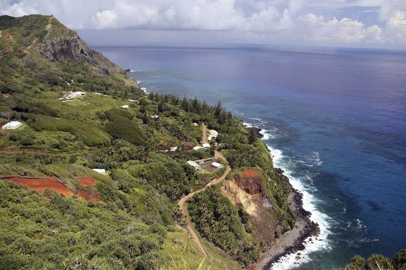
Roughly 50 people live in Adamstown, making it one of the least populated national capitals on the planet. Perched above Bounty Bay on a tiny volcanic island in the South Pacific, the settlement traces its roots to 1790, when the mutineers from the HMS Bounty and their Tahitian companions landed and decided to stay.
Their descendants are still there.
Getting to Pitcairn requires a sea voyage of several days from French Polynesia, and the approach to shore is made by longboat through often choppy waters. The path up from the bay is called the Hill of Difficulty, which is honestly the most accurate street name anywhere on Earth.
There is no airport, no ferry schedule, and no shortcut.
Despite the extreme distance from anywhere, Adamstown does have internet access, a small school, a post office, and a community hall. Residents fish, garden, and sell handcrafted souvenirs to the few supply ships that pass through each year.
Pitcairn honey has even developed a small international following. The island is remote by any measure, but its people have found creative ways to stay connected to the wider world.
Ittoqqortoormiit, Greenland
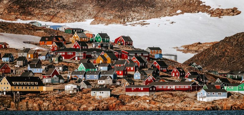
Ittoqqortoormiit is one of those place names that feels like a test, and reaching the town itself is no easier than pronouncing it. Tucked into East Greenland between the world’s largest national park and the vast Scoresby Sound fjord system, this is officially described by Visit Greenland as the country’s most isolated town.
Fewer than 350 people live here year-round.
There are no direct flights from other Greenlandic towns. Travelers fly from Iceland to a small airport, then cover the remaining 40 kilometers by helicopter, or by snowmobile and boat depending on the season.
Once inside the community, walking is basically the only way to get around because the town is compact and roads are minimal.
Hunting is not a hobby here; it is a way of life. Musk oxen, seals, and polar bears roam the surrounding landscape, and dog sledding remains a practical form of transport rather than a tourist attraction.
Enormous icebergs drift through the fjord in summer, creating a backdrop that looks almost too dramatic to be real. Visitors who make the effort to reach Ittoqqortoormiit consistently describe it as one of the most extraordinary places they have ever set foot.
Longyearbyen, Svalbard, Norway
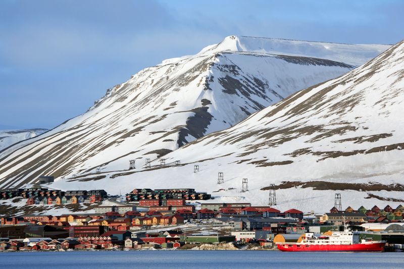
At 78 degrees north, Longyearbyen is so close to the North Pole that polar bears outnumber people on the surrounding archipelago. About 2,100 residents from dozens of countries live in this Norwegian settlement, making it the world’s northernmost community with a population above 1,000.
The sun vanishes completely for part of winter and stays up around the clock in summer.
Svalbard has roughly 40 kilometers of roads total, and not one of them connects Longyearbyen to the archipelago’s other settlements. Reaching those communities requires a snowmobile, a boat, or an aircraft.
Getting to Longyearbyen from mainland Norway means flying through Oslo or Tromso, which adds another layer of logistical planning most people never think about.
What surprises most visitors is how urban the place feels given its location. There are restaurants, a hospital, a university research center, a school, and shops selling everything from groceries to outdoor gear.
Longyearbyen started as a coal-mining town in the early 1900s and still has the rugged bones of that history visible in the landscape. Today it runs on tourism, science, and a shared appreciation for one of the most spectacular wild environments left on Earth.
Utqiagvik, Alaska
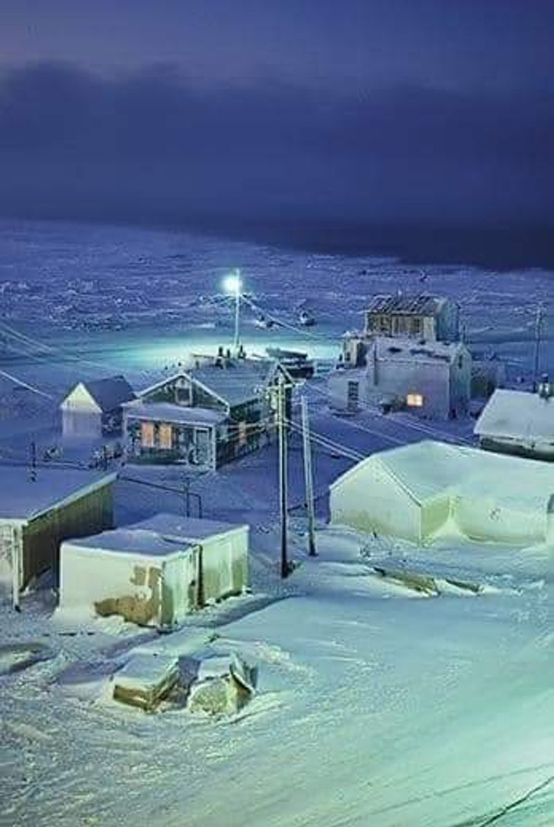
For 67 straight days every winter, the sun does not rise in Utqiagvik. That is not a typo.
This Arctic Ocean community, the northernmost city in the United States, experiences complete polar night from late November through late January, followed by a midnight sun that stays above the horizon from May through August. Around 4,300 people live here, and most of them are Inupiaq.
No highway connects Utqiagvik to the rest of Alaska. Planes from Anchorage and Fairbanks are the primary link to the outside world, carrying passengers, mail, and supplies across vast stretches of tundra.
A small road network exists within the community itself, but it does not go anywhere beyond town limits.
Subsistence hunting is woven deeply into everyday life here. Bowhead whale harvests are community events that bring people together in ways few outside traditions can match.
Seals, walrus, caribou, and migratory birds round out a diet that has sustained people in this region for over a thousand years. Modern services including schools, a hospital, and grocery stores exist alongside those ancient practices, creating a community that holds both worlds together with remarkable confidence.
Iqaluit, Nunavut, Canada
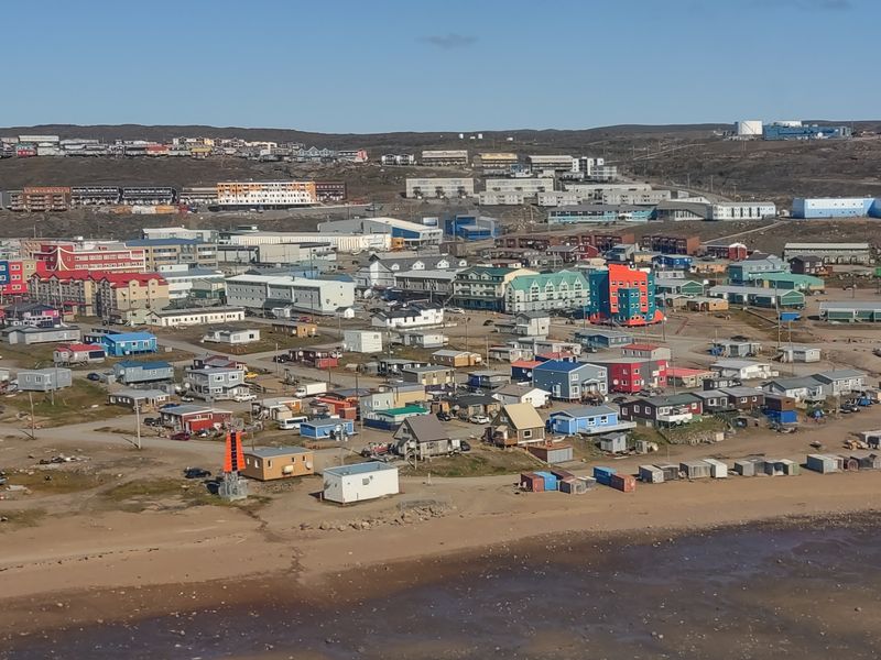
Iqaluit is a territorial capital that you cannot drive to from anywhere. Nunavut covers nearly two million square kilometers of Canadian Arctic territory, and not a single one of its communities is connected by road to southern Canada or to each other.
The only way in or out is by air or, during the brief summer shipping season, by sea.
That makes Iqaluit a genuinely unusual kind of city. It has government offices, courts, hotels, restaurants, and a proper airport, all of which serve a territory roughly the size of Western Europe.
Yet leaving by car is simply not possible because there is no road to leave on. Aircraft do the work that highways and trains perform in the south.
The city sits on Baffin Island at the northern end of Frobisher Bay, where tidal changes are dramatic and the landscape shifts with the seasons in ways that still catch long-time residents off guard. Inuit culture is a living presence in Iqaluit, not a museum exhibit.
Throat singing, traditional clothing, and local food markets are part of daily life. Visitors often arrive expecting a frontier outpost and leave impressed by a city that functions with real urban energy in one of the planet’s most demanding climates.
Supai, Arizona
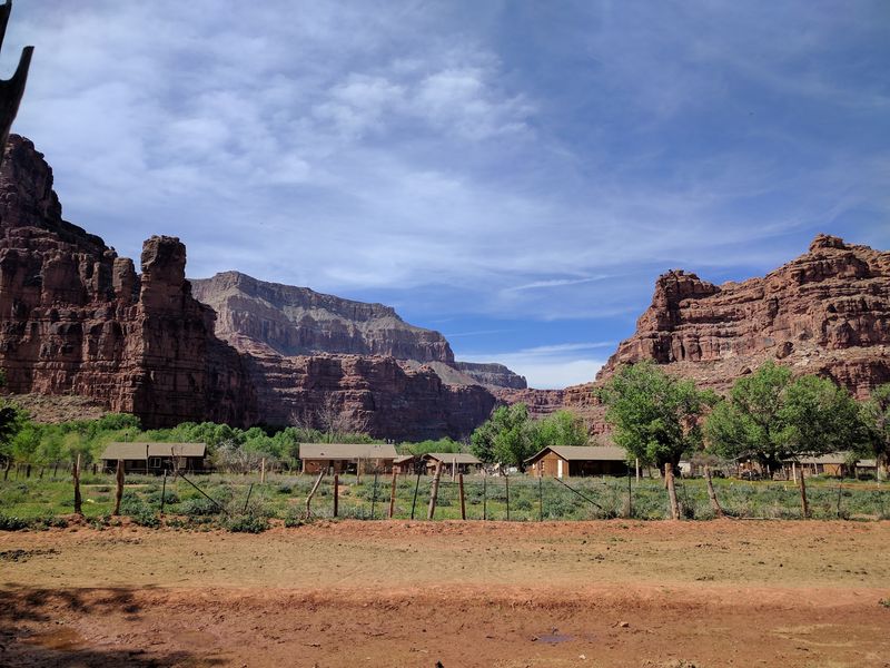
The U.S. mail is still delivered by mule to Supai, and that single detail tells you almost everything you need to know about how remote this place is. Sitting about 3,000 feet below the Grand Canyon rim in the heart of Havasupai territory, Supai has no road access whatsoever.
The only ways in are by foot, horse, mule, or a very limited helicopter service.
The trail from Hualapai Hilltop covers roughly eight miles of canyon terrain before the village appears. The Havasupai people have lived in this canyon for more than 1,000 years, making their community one of the longest continuously inhabited places in North America.
Supai has a post office, a lodge, a cafe, and a small store that stocks supplies brought in by pack animal.
Nearby Havasu Creek runs a shade of turquoise-blue that looks almost artificially colored, fed by mineral-rich springs that have been flowing long before anyone built anything near them. Tourism is carefully regulated, with visitors required to hold reservations well in advance.
The tribe manages access thoughtfully, balancing the economic value of tourism with the need to protect a canyon environment and a way of life that has survived here for generations against considerable odds.
Hanga Roa, Rapa Nui, Chile
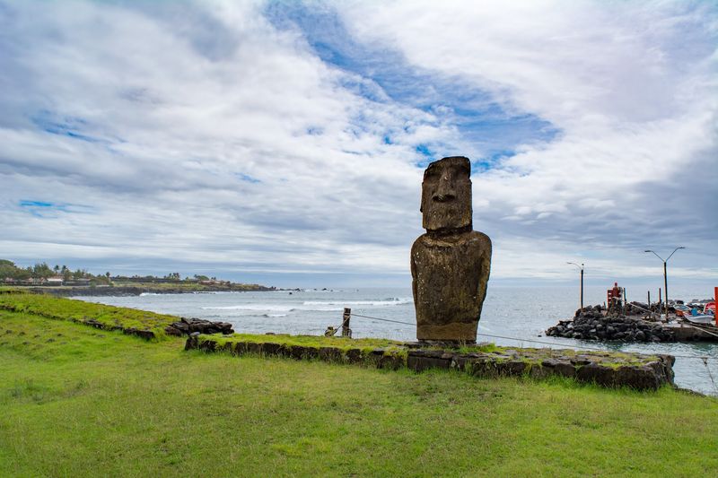
Standing on the main street of Hanga Roa, you are surrounded by the Pacific Ocean in every direction for thousands of kilometers. Rapa Nui, known internationally as Easter Island, is one of the most isolated inhabited islands on the planet, and Hanga Roa is its only real town.
About 7,000 people live here, most of Polynesian Rapa Nui descent.
The only regular flight connection is a roughly five-and-a-half-hour journey from Santiago, Chile, across an almost unbroken stretch of open ocean. The airport sits right next to town, which is convenient given that arriving any other way would require an extremely long boat trip.
Hanga Roa has markets, restaurants, dive shops, and a harbor that serves the small fishing fleet.
Beyond the town limits, the volcanic landscape of Rapa Nui National Park takes over, dotted with the famous stone moai figures that have puzzled and fascinated researchers for centuries. Local Rapa Nui culture has survived remarkable pressures over the past 200 years, and residents today balance tourism income with efforts to preserve their language, traditions, and ancestral sites.
Visiting feels less like a vacation and more like stepping into a place that exists slightly outside the normal rules of geography.
Coober Pedy, South Australia
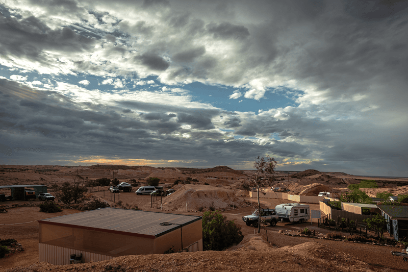
When summer temperatures regularly top 50 degrees Celsius above ground, sensible people go underground. That is exactly what the residents of Coober Pedy did, and it turned out to be a brilliant solution.
This South Australian outback town became famous for opal mining, but its real claim to fame is a community where homes, churches, hotels, and even art galleries are carved into the rock beneath the desert surface.
About 1,566 people officially call Coober Pedy home, though the population shifts with mining activity. The surrounding landscape looks almost lunar, covered in pale spoil heaps from decades of digging, with very few trees and almost no shade.
Getting there from Adelaide involves a drive of roughly 850 kilometers through increasingly sparse outback terrain.
Underground dugouts maintain a naturally stable temperature year-round without air conditioning, which is both practical and surprisingly comfortable. The town has a supermarket, medical facilities, a school, and fuel stops that serve travelers crossing the Stuart Highway.
Coober Pedy proves that extreme remoteness does not require an ocean or a polar ice cap. Sometimes it just means building a functioning, creative community right in the middle of a vast, scorching continental interior where most people would not last a week.
La Rinconada, Peru
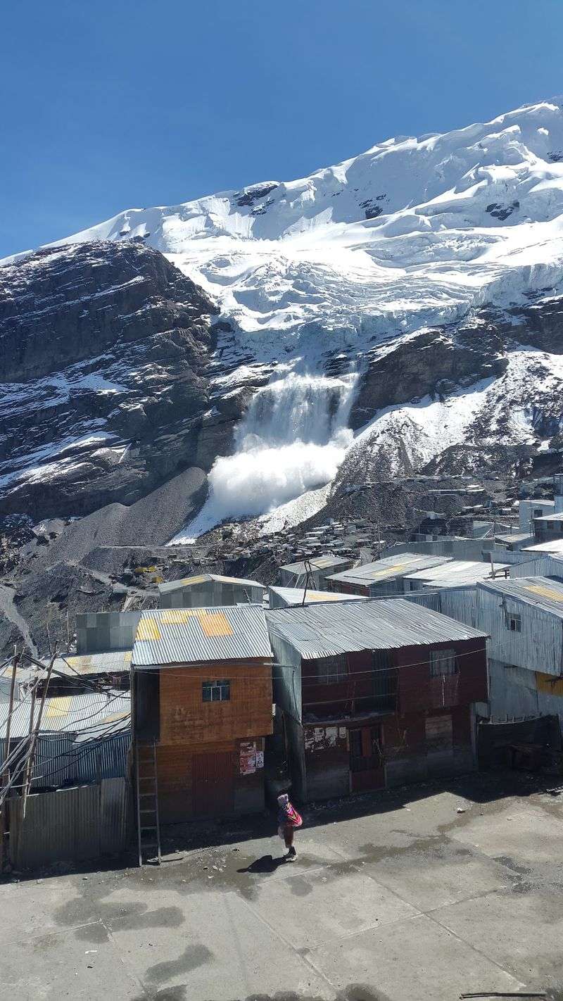
At 5,200 meters above sea level, every breath in La Rinconada delivers noticeably less oxygen than your lungs expect. This Peruvian mining settlement clings to the slopes of the Ananea glacier range in the Puno region, and it is widely recognized as one of the highest permanently inhabited communities on Earth.
Thousands of families have relocated here chasing gold deposits buried beneath the ice.
The settlement grew organically around the mines rather than through any planned development, which shows in its layout. Corrugated metal buildings stack up along steep, unpaved paths at angles that would make a mountain goat reconsider.
Infrastructure is limited, cold is constant, and the altitude creates health challenges for newcomers that take weeks to overcome.
Mining conditions are notoriously harsh, with many workers operating under an informal payment system that offers no guaranteed daily wage. Environmental concerns around mercury contamination have drawn international attention to the settlement.
Yet people continue to arrive, drawn by the possibility of a significant gold find that could change their financial situation entirely. La Rinconada did not develop because anyone planned a town at this altitude; it grew because the mountains held something valuable, and human determination found a way to reach it.
Churchill, Manitoba, Canada
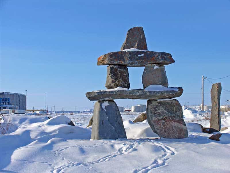
Churchill has a sign at the edge of town reminding residents to leave their car doors unlocked so that anyone caught outside by a polar bear can quickly duck inside for shelter. That is the kind of detail that sets a place apart.
Sitting on the western shore of Hudson Bay about 1,000 kilometers north of Winnipeg, Churchill has no roads connecting it to the rest of Canada.
Visitors arrive by plane or by rail, with the train journey from Winnipeg taking roughly 36 to 48 hours through increasingly sparse boreal forest and eventually open tundra. The rail line has faced closures due to flooding in recent years, making the community’s connection to the south genuinely fragile at times.
Churchill has a population of around 900 people who manage that uncertainty with notable composure.
The wildlife situation here is extraordinary by any standard. Polar bears gather along the coast each autumn as they wait for Hudson Bay to freeze, making Churchill one of the best places on Earth to observe them.
Beluga whales crowd the Churchill River estuary in summer by the thousands. The northern lights are visible on up to 300 nights per year.
Churchill is remote, occasionally bear-adjacent, and completely unforgettable.
Tasiilaq, Greenland
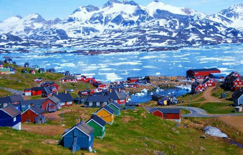
Tasiilaq is the biggest town in East Greenland, which sounds reassuring until you learn that there are no direct flights to it. Visit Greenland confirms that Ammassalik Island, where the town sits, is considered one of the most remote regions in the world.
Reaching Tasiilaq typically involves flying to Reykjavik or Nuuk and then catching a connecting helicopter that hops between settlements along the coast.
The landscape surrounding the town is the kind that makes even experienced travelers stop mid-sentence. Steep mountain walls drop directly into fjords filled with drifting icebergs, and the treeless terrain stretches in every direction without a road in sight.
Around 2,000 people live in Tasiilaq, making it a genuine community rather than a research station or a seasonal camp.
Inuit drum dancing is still practiced here as a living cultural tradition, not a performance put on for tourists. Dog sledding and hunting remain practical parts of life rather than nostalgic hobbies.
Seasons dictate everything from transportation options to food availability. Getting around the wider region depends entirely on whether you have access to a helicopter, a boat, a dog sled, or a snowmobile.
Tasiilaq is the kind of place that teaches you very quickly how much infrastructure most people take for granted.
Ushuaia, Argentina
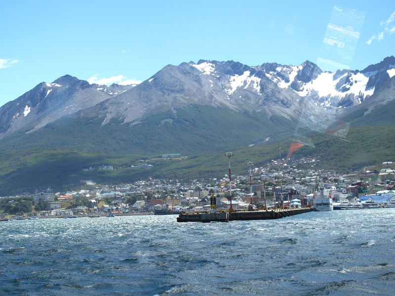
Ushuaia wears the title of southernmost city in the world with obvious pride, and the landscape makes the claim feel completely believable. The Beagle Channel stretches out in front of the city while the Martial Mountains rise sharply behind it, giving Ushuaia a geography that looks like someone squeezed a city into the last available strip of land before Antarctica begins.
The continent of Antarctica is closer than Buenos Aires.
Tierra del Fuego, the island where Ushuaia sits, is separated from mainland Argentina by the Strait of Magellan, adding one more layer of geographic drama to an already dramatic address. The city has a population of around 82,000 people, which makes it far more urban than most entries on this list.
An international airport and a busy cruise ship port handle the steady flow of Antarctic expedition travelers.
The remote location once made Ushuaia attractive as the site of a high-security prison, which operated from 1904 to 1947 and is now a popular museum. Today the same end-of-the-world setting draws hikers, skiers, wildlife enthusiasts, and travelers who simply want to stand at the edge of the inhabited world and look south toward the ice.
Ushuaia has figured out that extreme geography, handled well, is one of the best tourism assets imaginable.
Share this story