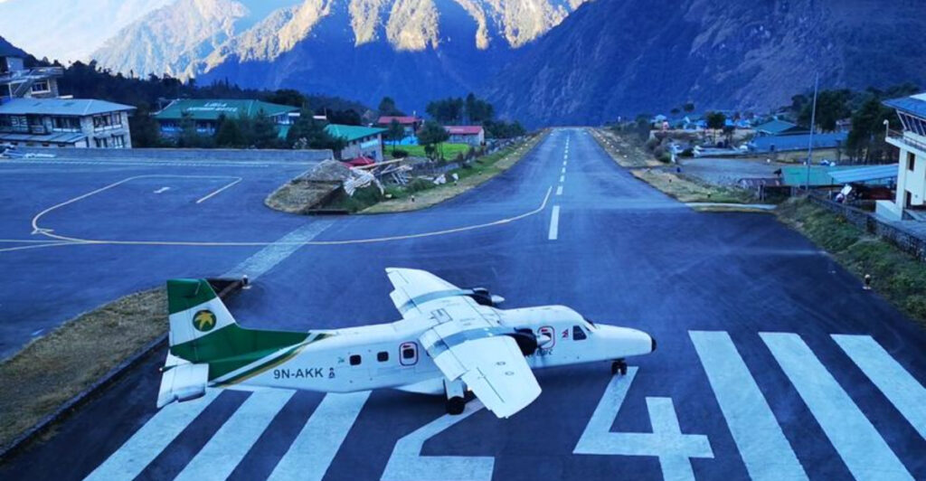
Some airports make landing feel like threading a needle at 150 miles per hour. Pilots who fly into these places deal with short runways, towering mountains, ocean cliffs, and weather that can change in minutes.
These airports push aircraft and crew to their limits, yet flights operate safely thanks to strict training requirements, special procedures, and carefully designed approach paths. Get ready to discover 15 runways that make even experienced aviators pay extra close attention.
Paro International Airport, Bhutan
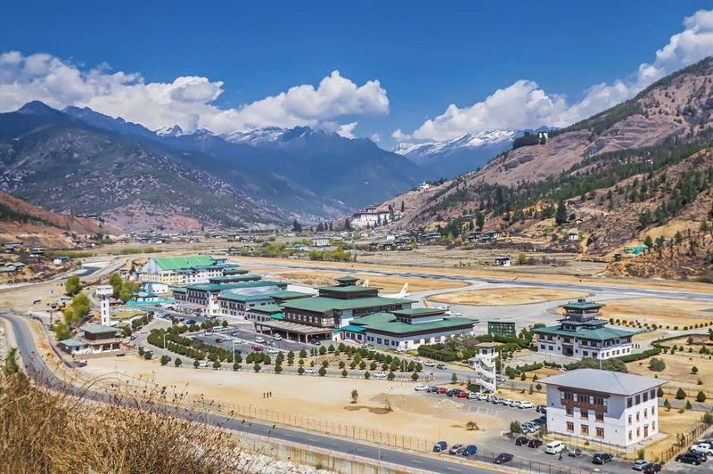
Only a handful of pilots in the entire world are certified to fly into Paro, and after one look at the approach, it is easy to understand why. The aircraft must weave through a narrow Himalayan valley, following twisting terrain while surrounded by peaks that rise well above the flight path.
The runway itself does not appear until pilots complete a tightly timed visual turn near the end of the arrival.
Bhutan’s Department of Air Transport closely manages the airport’s aeronautical procedures, and airlines must ensure their crews receive specialized local training before operating independently. Afternoon thermals and mountain wind shifts can further restrict the window of safe operations each day.
The airport essentially has its own rulebook that sits on top of standard aviation requirements.
Despite the challenges, Paro handles international arrivals from several regional carriers, connecting this small Himalayan kingdom to the wider world. The scenery on approach is genuinely breathtaking, with forested ridges and ancient dzong fortresses visible through the cockpit window.
Few airports in the world blend natural beauty with technical difficulty quite so dramatically as this one.
Madeira Cristiano Ronaldo Airport, Portugal

Madeira’s airport has a runway that literally floats over the sea on enormous concrete pillars, and that visual alone tells you this is not your average arrival. The original runway was far too short for modern jets, so engineers extended it outward over the Atlantic Ocean, creating one of the most visually striking runway platforms anywhere in the world.
Strong, swirling winds that develop around the island’s volcanic mountains can make the approach feel unpredictable even on otherwise calm days.
Portugal’s aeronautical regulations require pilots to complete specific airport training before operating here independently. A captain must log at least 200 hours in command on the relevant aircraft type before even beginning that qualification process.
The curved visual approach required during certain wind conditions adds another layer of skill that standard airline training does not automatically cover.
The airport sits on a narrow coastal shelf between steep terrain and open ocean, leaving almost no margin on either side of the runway centerline. Crosswind components can be significant, and wind direction can shift quickly as gusts deflect off the surrounding cliffs.
Madeira rewards pilots who prepare thoroughly, and passengers are rewarded with one of the most scenic final approaches over Atlantic waters.
Juancho E. Yrausquin Airport, Saba
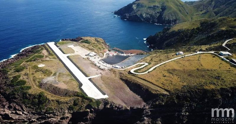
Four hundred meters. That is all the pavement available at Saba’s Juancho E.
Yrausquin Airport, making it widely recognized as the shortest runway serving scheduled commercial flights anywhere on Earth. The strip sits on a small flat shelf carved out of the island’s rocky coastline, with steep terrain on one side and a sheer drop to the Caribbean Sea on the other.
There is absolutely no room for a long landing or a slow deceleration.
Only specially certified small turboprops with exceptional short-field performance are permitted to operate scheduled services here. Even those aircraft must land with precise speed control, touching down as close to the threshold as possible to maximize the available stopping distance.
A slightly fast or long approach would carry the aircraft straight off the end of the runway and into the sea.
Saba is a tiny Dutch Caribbean island known for excellent scuba diving and dramatic volcanic scenery. The airport is essentially the island’s only practical air link to the outside world, connecting it with nearby Sint Maarten and other regional destinations.
Pilots who fly into Saba regularly describe it as demanding respect every single time, no matter how many times they have done it before.
Tenzing-Hillary Airport, Lukla, Nepal
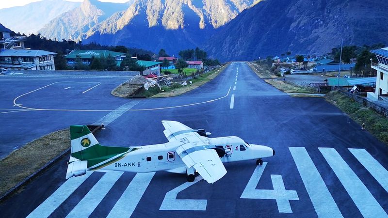
Perched at roughly 2,845 meters above sea level, Lukla’s runway looks less like an airport and more like a ski jump that forgot to curve upward. At only about 527 meters long, the strip tilts uphill toward a solid rock wall at one end and drops into a deep Himalayan valley at the other.
Pilots get exactly one shot at a safe landing, because a go-around is nearly impossible once the approach is committed.
Only specially certified short-takeoff-and-landing aircraft operate here, mostly small Twin Otters and similar turboprops. Weather in the Himalayas shifts without much warning, so clear skies at departure can become thick cloud by arrival.
Flights are routinely delayed or cancelled because of rapidly changing visibility.
Every trekker heading toward Mount Everest Base Camp passes through this tiny terminal, making Lukla one of the busiest remote airports on the planet. Pilots must hold specific approvals, and the combination of high altitude, extreme terrain, and short runway length keeps this airport at the top of nearly every challenging-runway conversation worldwide.
Courchevel Altiport, France
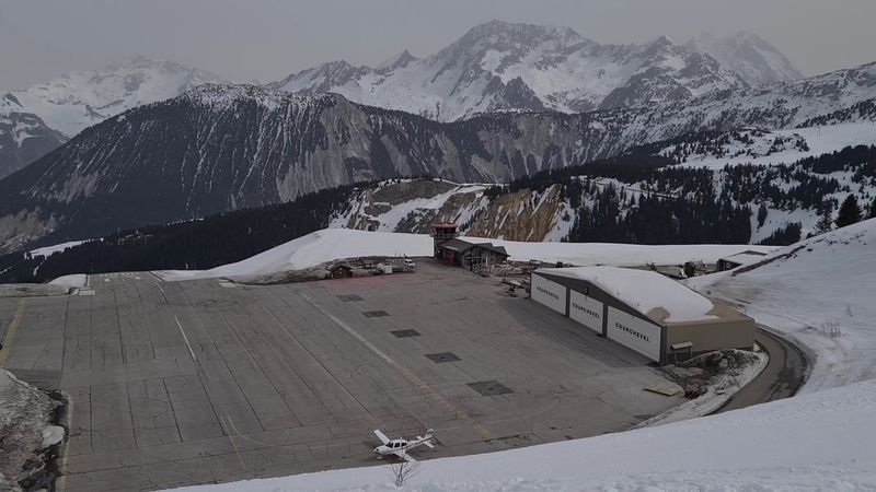
Imagine landing on a runway that slopes uphill at nearly 18.5 percent gradient while surrounded by the French Alps at over 2,000 meters elevation. That is a normal Tuesday at Courchevel Altiport.
The strip measures only about 525 meters long, and the slope is not subtle. Pilots essentially aim at the hillside, land on the rising surface to help slow the aircraft naturally, and then taxi to the top of the ramp.
Thin mountain air reduces engine power and aerodynamic lift, meaning aircraft performance is noticeably different here compared to a sea-level airport. Operations are restricted to pilots who hold a specific mountain flying qualification, and only suitable aircraft with appropriate short-field capabilities are permitted.
Snow and ice can further reduce braking effectiveness on the sloped surface.
Courchevel is one of Europe’s most exclusive ski resorts, and the altiport serves private jets and small charter aircraft bringing wealthy visitors directly to the slopes. Departures are equally dramatic because aircraft use the downhill slope to accelerate before launching off the lower end of the runway into the valley below.
Few aviation experiences anywhere in Europe match the sheer spectacle of a Courchevel arrival or departure.
Gustaf III Airport, Saint Barthelemy
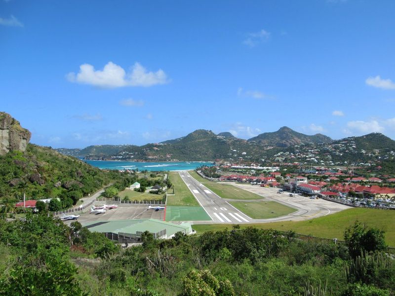
Saint Barthelemy’s Gustaf III Airport greets arriving aircraft with a hilltop directly in the approach path, meaning pilots must descend sharply over the ridge before touching down on a runway that stretches barely 646 meters to the water’s edge. The final approach angle is steep enough that passengers on board often feel like the aircraft is diving rather than landing.
At the far end of the runway, a public beach and the brilliant Caribbean Sea wait just beyond the pavement.
The approach is entirely visual, and pilots must receive specific airport authorization before operating here without supervision. Large commercial jets simply cannot use the strip because the combination of short length and challenging approach geometry makes it unsuitable for anything much bigger than a regional turboprop.
Private aircraft and small island-hopper services dominate the schedule.
St. Barts is famous as a playground for celebrities and sailing enthusiasts, and the airport’s dramatic setting matches the island’s reputation for being slightly over the top in the best possible way. Watching an aircraft arrive from the beach below has become something of a local spectator sport.
Pilots who master the Gustaf III approach earn a certain quiet pride that regular airport landings simply cannot provide.
Barra Airport, Scotland
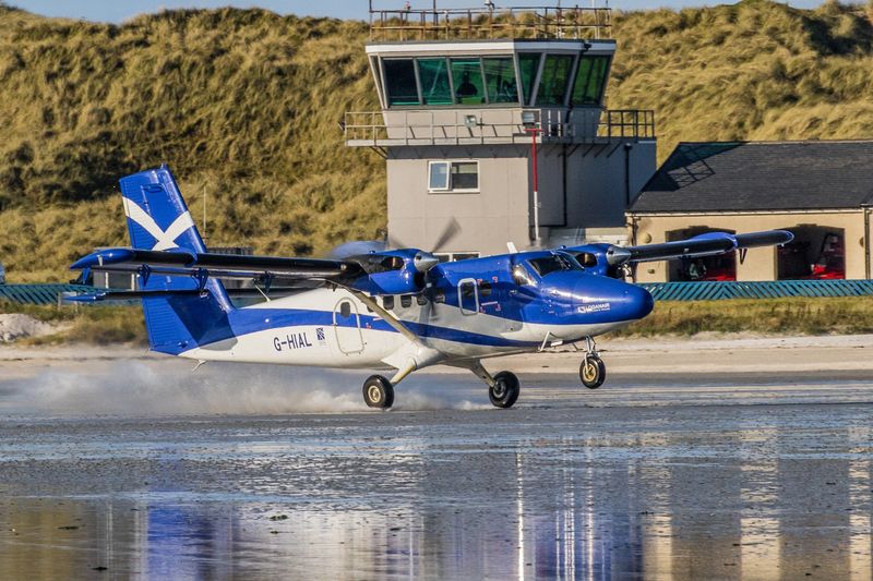
Twice a day, the sea reclaims Barra Airport’s runways, and there is nothing the ground crew can do about it except check the tide tables and plan accordingly. Barra is the only commercial airport in the world where scheduled flights land directly on a tidal beach.
Three marked directions on the sand of Traigh Mhor allow pilots to choose their landing route based on wind conditions, much like a natural windsock built into the landscape itself.
When the tide comes in, the runways simply disappear beneath the Atlantic, which means the flight schedule is built around tidal predictions rather than conventional slot times. The surface varies with weather and sea conditions, and the exposed location on Scotland’s Outer Hebrides means wind, rain, and sea spray are frequent companions.
Pilots must handle a surface that no simulator fully replicates.
Loganair operates the scheduled service connecting Barra with Glasgow, making it one of the most unusual airline routes in Europe. The aircraft of choice is the de Havilland Twin Otter, whose rugged construction and short-field ability make it well suited to the beach environment.
Locals take the whole arrangement completely in stride, treating tidal landings as simply part of island life.
Tonconton Airport, Honduras
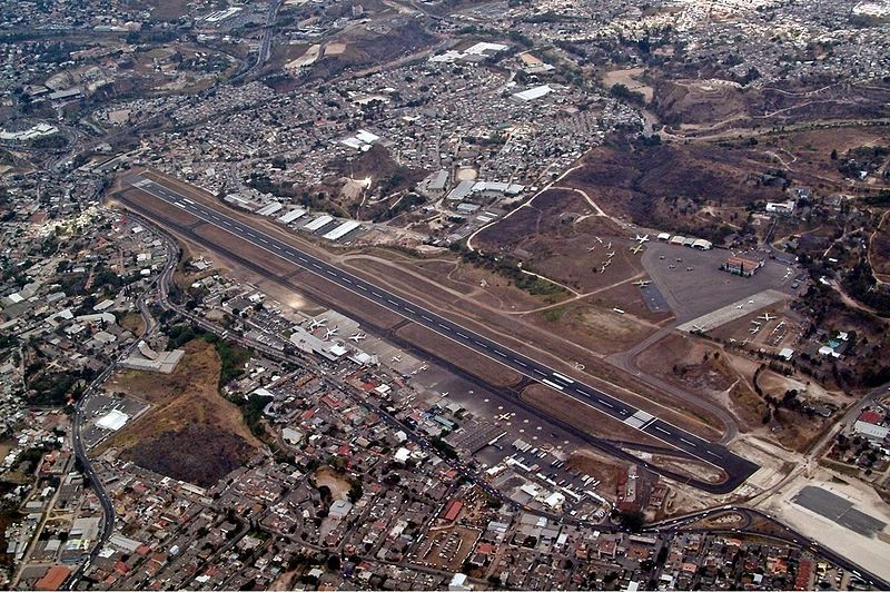
Flying into Tegucigalpa’s Toncontin Airport means threading a commercial airliner through mountains, over densely packed neighborhoods, and around a tight curve, all within the final minutes before touchdown. The approach to Runway 02 follows lower terrain through a valley before requiring a significant directional turn to align with the runway centerline.
Pilots essentially finish lining up with the runway at a point where most airports would already have the aircraft firmly on the ground.
The airport sits at more than 3,000 feet above sea level, which reduces aircraft performance compared to a sea-level airport of the same runway length. At approximately 2,163 meters, the runway is longer than several others on this list, but the combination of surrounding terrain, late alignment, urban obstacles, and elevation creates a uniquely demanding arrival package.
Calculating aircraft weight and performance margins carefully is not optional here.
Several incidents over the years have led airlines and regulators to tighten requirements for pilots operating at Toncontin. Some carriers have adjusted their fleet assignments or approach procedures to improve safety margins on this particular route.
The airport remains an important gateway to Honduras’s capital city, but it commands genuine respect from every crew that flies the approach.
Gibraltar International Airport
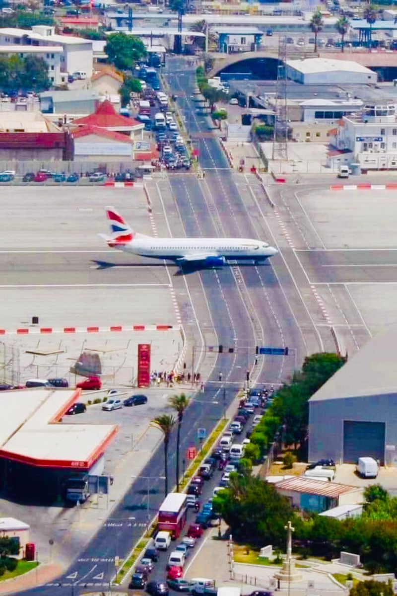
Gibraltar International Airport has a feature so unusual that visitors stop and stare: the main road into the British territory used to cross the active runway, with traffic lights and barrier arms halting cars every time an aircraft needed to land or take off. Most vehicle traffic now uses a tunnel, but the crossing still operates for certain traffic.
Add the enormous Rock of Gibraltar looming beside the approach path, and you have an airport that makes even routine arrivals feel theatrical.
Airflow around the Rock creates turbulence and unpredictable crosswinds that can catch pilots off guard during the final stages of approach. The runway stretches across a narrow strip of land with the Bay of Gibraltar at one end and the Mediterranean Sea at the other, leaving no room for an overrun in either direction.
Restricted airspace around the Rock further constrains the approach and departure paths available.
Despite its quirks, Gibraltar handles scheduled services from several European carriers, connecting the territory with the United Kingdom and Spain. The combination of confined airspace, sea-level crosswinds, terrain-induced turbulence, and the sheer visual strangeness of the road crossing gives Gibraltar a personality unlike any other airport in Europe.
It is compact, complicated, and completely one of a kind.
Queenstown Airport, New Zealand
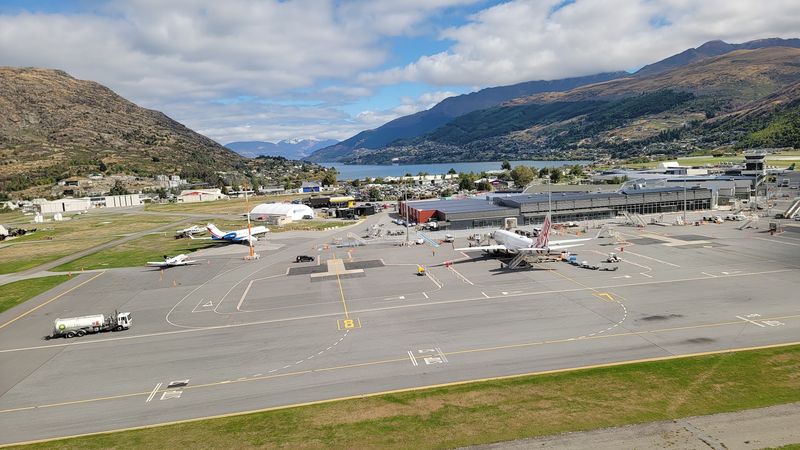
Few airports in the world offer an arrival view as jaw-dropping as Queenstown, where aircraft descend toward a narrow basin framed by the jagged Remarkables mountain range and the glittering surface of Lake Wakatipu. The scenery is spectacular, but the terrain that creates it also restricts how pilots can approach and depart.
Rising ground on multiple sides limits maneuvering options and compresses the available airspace into carefully defined corridors.
Mountain winds, rapidly shifting weather, and winter icing conditions add layers of complexity that warm-weather airports simply do not experience. A missed approach at Queenstown requires precise execution because the surrounding terrain leaves little room for improvisation.
Pilots must follow exactly designed paths and altitudes without deviation.
Advanced satellite-based navigation procedures now guide aircraft along precise curved paths through the terrain, a significant improvement over earlier approaches that depended more heavily on visual references. The technology has improved operational reliability and expanded the weather windows during which flights can safely arrive.
Queenstown handles a large volume of tourist traffic year-round, particularly during ski season, making efficient and safe operations at this challenging airport a genuine priority for New Zealand aviation authorities and the airlines that serve it.
Innsbruck Airport, Austria
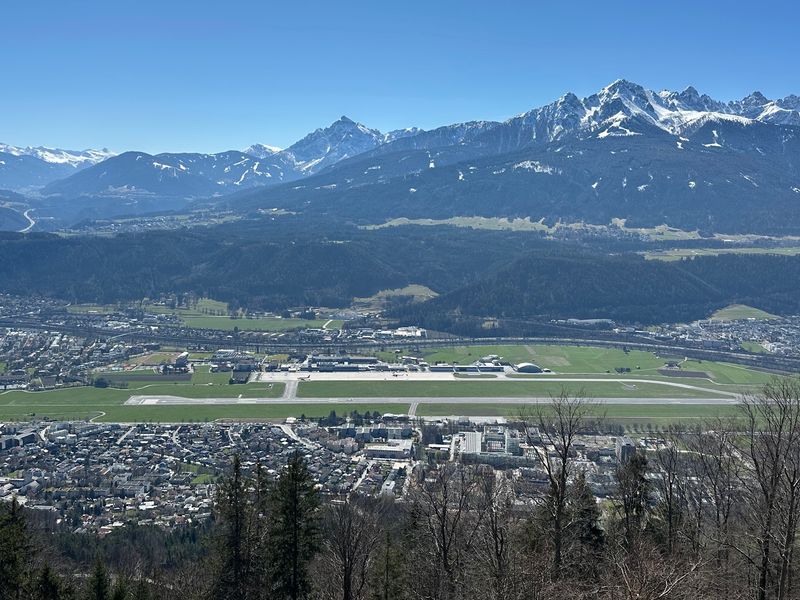
Innsbruck Airport sits inside the Inn Valley like a coin dropped into a narrow slot, with the Austrian Alps rising steeply on both sides and leaving pilots with a very specific set of arrival and departure options. There is no casual circling above the airport to get established on a comfortable final approach.
Aircraft must follow the valley, respect the terrain, and commit to a precise flight path that the mountains essentially dictate.
Wind direction in alpine valleys can create complicated flow patterns, sometimes requiring unusual arrival or departure headings that feel counterintuitive compared to flat-country airports. Cloud and snow can obscure the surrounding peaks, making terrain awareness a constant priority even when modern navigation systems are doing much of the guidance work.
The runway measures approximately 2,000 meters, which is workable but not generous for larger aircraft operating in mountain conditions.
Innsbruck serves as a major gateway for skiers heading to Tyrolean resorts, and the airport handles a busy schedule of seasonal charter and scheduled flights from across Europe. Airlines operating here ensure their crews complete specific mountain airport training before flying the route independently.
The Inn Valley setting makes every arrival feel like a carefully choreographed performance between the aircraft and the surrounding landscape.
Aspen-Pitkin County Airport, Colorado
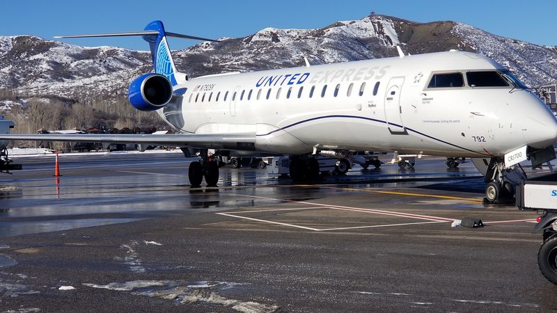
At 7,820 feet above sea level, Aspen-Pitkin County Airport sits high enough that the air itself becomes part of the challenge. Thinner air at altitude means engines produce less thrust and wings generate less lift, so aircraft need more runway to accelerate and more distance to climb after takeoff.
On a warm summer afternoon, those performance penalties stack up quickly, and pilots must calculate their numbers with extra care before every departure.
The surrounding Rocky Mountain terrain restricts approach and departure paths to specific corridors, and a missed approach requires immediate precise maneuvering to avoid rising ground. Winter brings snow, ice, and gusty mountain winds that can change direction and strength with little warning.
Aircraft weight limits are strictly enforced here, and airlines sometimes must offload passengers or cargo to stay within safe operating margins.
Aspen is one of America’s most famous ski destinations, attracting celebrities, executives, and outdoor enthusiasts throughout the winter season. The airport handles a mix of regional airline flights and private jet traffic, both subject to the same elevation-driven performance constraints.
Pilots who fly here regularly describe a healthy respect for the mountain environment that no amount of experience ever completely removes. Preparation and precision are the price of admission.
Telluride Regional Airport, Colorado
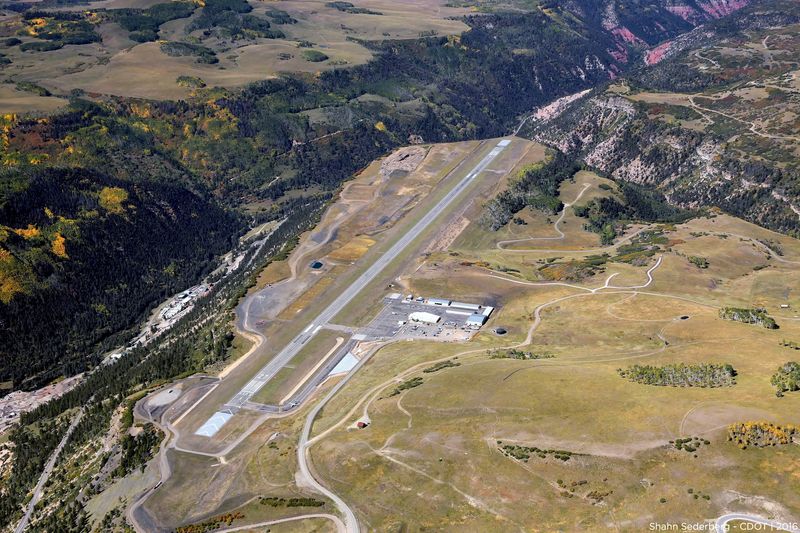
Standing at 9,078 feet above sea level, Telluride Regional Airport holds the title of highest commercial airport in North America, and it wears that distinction with a kind of dramatic flair. The runway sits on a high mesa plateau, which means the pavement appears to float above the surrounding valleys like an elevated table in the middle of the Rocky Mountains.
Pilots approaching from below must climb to reach the runway elevation before touching down, which creates a visually striking and technically unusual arrival geometry.
The thin air at this altitude significantly reduces both engine performance and aerodynamic efficiency. Aircraft that handle perfectly at sea level feel noticeably less responsive here, requiring adjusted speeds, longer takeoff rolls, and careful weight management.
Mountain winds and rapidly developing afternoon thunderstorms during summer months add unpredictability to an already demanding operating environment.
Telluride is a beloved Colorado ski and festival destination, drawing visitors year-round despite its remote setting. The airport’s plateau location can create visual illusions during approach, particularly for pilots not yet familiar with high-altitude plateau operations.
Depth perception and glide path judgment work differently when the surrounding valleys drop away so dramatically. Airlines and charter operators ensure pilots receive proper high-altitude training before scheduling them onto Telluride routes.
Princess Juliana International Airport, Sint Maarten

Maho Beach has become one of the most photographed spots in aviation simply because large commercial jets pass overhead at a height that makes beachgoers duck instinctively. Aircraft approaching Runway 10 at Princess Juliana International Airport cross the beach boundary fence at very low altitude before touching down, creating a spectacle that has gone viral countless times on social media.
The physics of the approach are entirely normal by aviation standards, but the visual effect is genuinely startling.
The airport occupies a narrow strip of Sint Maarten’s coastal terrain, with water and limited island geography on multiple sides. Caribbean trade winds are generally consistent, but tropical weather systems and seasonal squalls can introduce crosswind components and reduced visibility that complicate arrivals.
The runway length is workable for wide-body jets, but the surrounding water and terrain leave little margin for significant deviations from the planned approach path.
Princess Juliana has historically served as a major hub for Caribbean island connections, handling flights from North America, Europe, and neighboring islands. The beach crossing is a genuine aviation phenomenon that has made Sint Maarten internationally recognizable.
Despite the dramatic visuals, every flight operates under standard safety regulations, and the approach is carefully charted and approved by aviation authorities.
Narsarsuaq Airport, Greenland
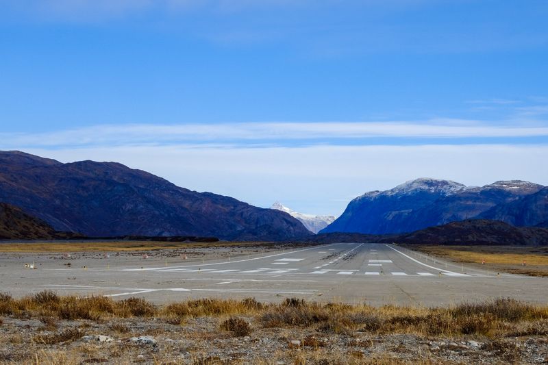
Narsarsuaq Airport earned its reputation the hard way, with decades of aircraft navigating a long, winding Greenlandic fjord just to reach the runway at the far end. The fjord approach required pilots to fly through a corridor of rock walls and unpredictable mountain winds while monitoring cloud layers that could seal the exit route behind them.
Visibility, turbulence, and icing were constant concerns rather than occasional inconveniences.
The airport was originally built by the United States military during World War II as a refueling stop for aircraft crossing the North Atlantic. That wartime heritage gave it an air of rugged necessity that commercial aviation eventually inherited.
For decades after the war, it served as one of the primary gateways into southern Greenland, handling everything from small propeller aircraft to larger regional jets.
The airport’s role shifted significantly around 2026 when regional flights began transferring to the newly opened Qaqortoq Airport, which offers a more accessible and less terrain-constrained operating environment. Narsarsuaq now stands as a remarkable example of how demanding legacy infrastructure eventually gives way to better-designed modern facilities.
Its fjord approach remains one of aviation history’s most memorable challenges, a reminder of how far aircraft operations have come since those early wartime crossings.
Share this story