Old ruins are like time capsules made of stone, brick, and dirt. They show us where people slept, what they ate, how they got water, and even how they kept their cities clean.
Some sites are packed with temples, while others reveal ordinary streets and homes. Get ready to visit fifteen places across the globe that make the past feel surprisingly close.
Mohenjo-daro, Pakistan
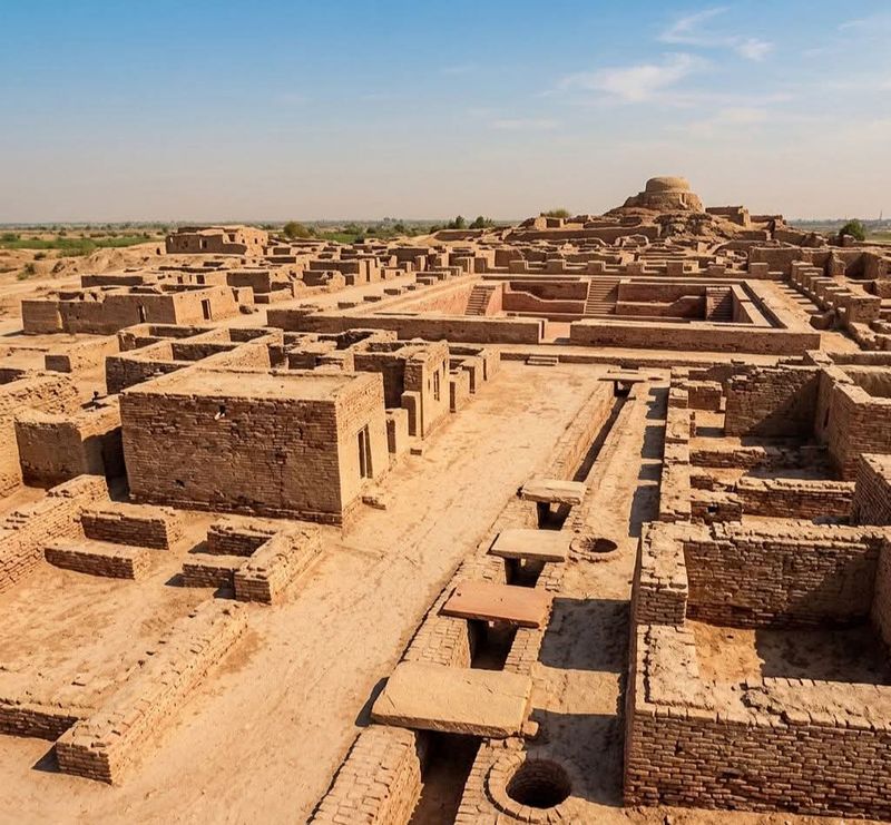
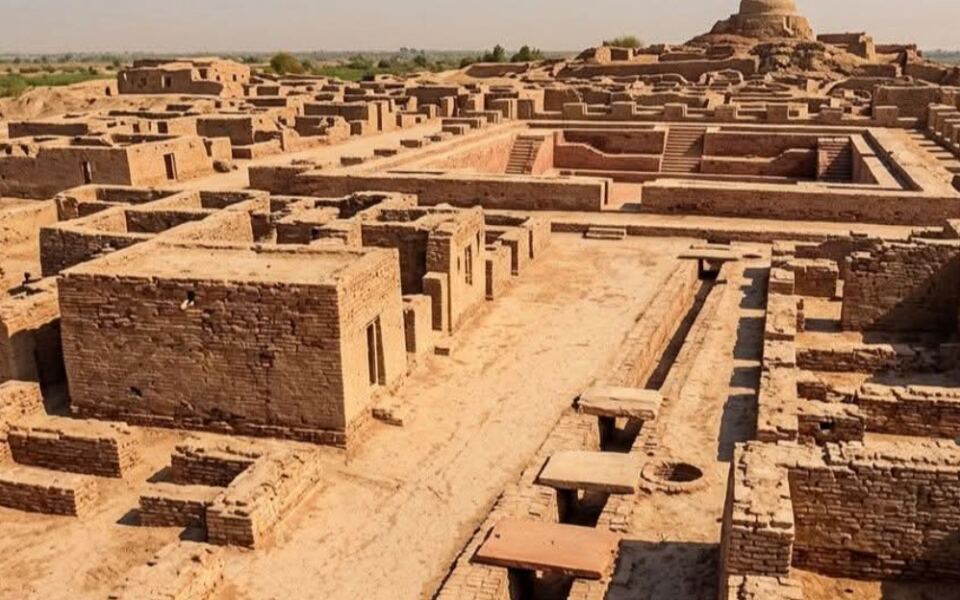
Picture a city where nearly every street meets another at a neat right angle. That is Mohenjo-daro, a major center of the Indus civilization built in the third millennium B.C.
Its planners clearly liked order.
Houses were made from standardized baked bricks, so walls fit together with tidy precision. Many homes had wells and bathing areas, and waste water flowed into covered drains along the streets.
Soak pits helped handle what the drains could not.
A raised citadel stood above the lower residential districts, where families lived and worked. The famous Great Bath hints at public ritual or shared cleanliness.
What stands out most is that sanitation was part of the original design, not an afterthought for the wealthy.
Walking its lanes today, visitors can spot drain channels still tracing the edges of old streets. Imagine the plumbing headaches this city avoided thousands of years ago.
Plenty of modern towns still struggle with the same problem.
Fun fact: the name Mohenjo-daro is often translated as Mound of the Dead, though nobody knows what its residents called it. Their writing remains undeciphered, so the bricks do most of the talking.
Çatalhöyük, Türkiye
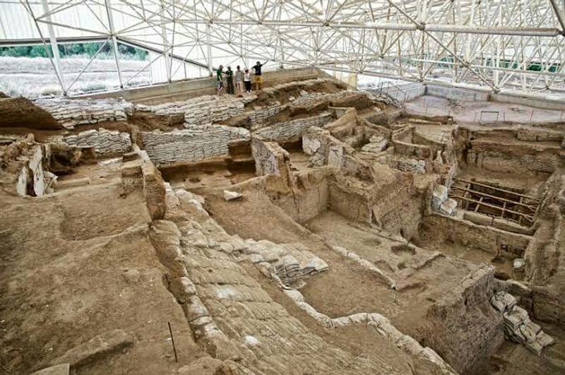
Forget front doors and sidewalks. In Çatalhöyük, people climbed down a ladder through a hole in the roof to get home.
Between about 7400 and 5200 B.C., this Neolithic town packed its houses wall to wall with almost no streets between them.
Rooftops worked as walkways, so neighbors likely strolled across them to visit. Inside, homes held hearths, storage areas, and sleeping platforms.
Archaeologists have also found wall paintings, plaster reliefs, and sculptures.
Burials were placed beneath the floors, which means families lived right above their ancestors. That tells us a lot about how these people thought of home and memory.
The site grew in layers, as new houses were built right on top of old ones. Digging through those layers is like flipping through a very dusty photo album.
Each page shows how village life slowly became more complex.
Çatalhöyük proves that a crowded settlement did not need a street plan to work. It also shows that early farmers cared about art and ritual as much as food and shelter.
Skara Brae, Scotland
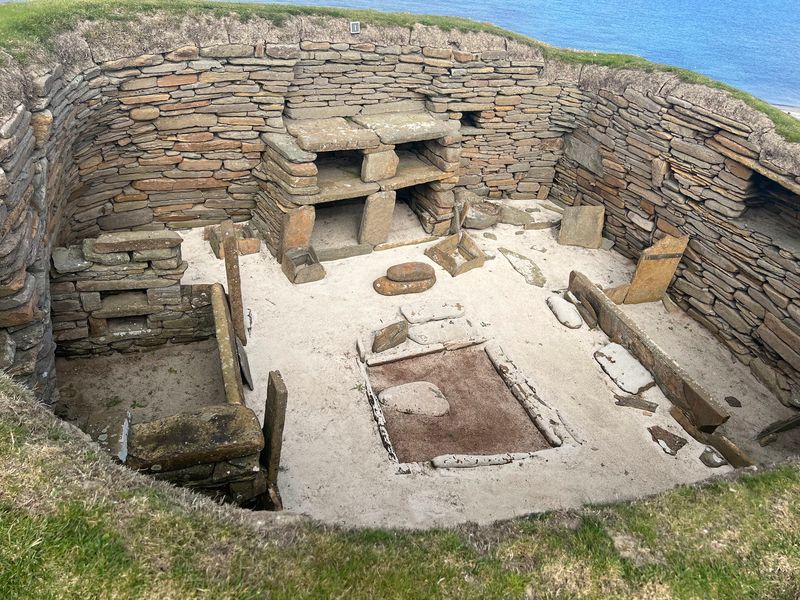
A stone bed, a stone shelf, and a stone cupboard: Skara Brae is a house tour with very little wood. This Neolithic village on Orkney is about 5,000 years old.
A great storm uncovered it after centuries under sand.
Each home had a central hearth, built-in beds, and storage boxes. A large stone dresser faced the doorway, perhaps to show off treasured items.
Narrow covered passages linked the houses, which likely kept out the wild island wind.
Because sand buried the village so well, the furniture layout survives in remarkable detail. Many ancient sites are famous for tombs and ceremonies.
Skara Brae shows where regular families cooked, slept, and chatted.
The village is part of a larger Neolithic landscape on Orkney. Nearby are Maeshowe, the Stones of Stenness, and the Ring of Brodgar.
Together they give a full picture of daily life and sacred life in northern Europe.
Visitors often say they feel like they just missed the residents leaving for the day. It is cozy, cramped, and oddly familiar.
Mycenae, Greece
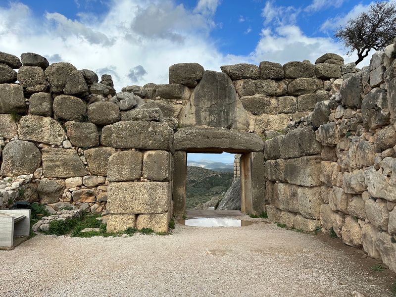
Walls so huge that later Greeks swore giants built them. Mycenae’s fortifications are made of enormous stones, and the legend of the Cyclopes stuck.
The citadel thrived from about the 15th to the 12th centuries B.C.
Visitors enter through the Lion Gate, where two carved lions guard the entrance. Inside are palace remains and royal burial areas.
Nearby, great beehive-shaped tholos tombs show how much rulers invested in the afterlife.
Mycenae was not just about muscle. Clay tablets written in Linear B, found at Mycenaean centers, record goods, workers, and supplies.
They are among the earliest written evidence of the Greek language.
Those tablets reveal a palace economy where officials tracked sheep, grain, and oil. Think of a very serious, very ancient spreadsheet.
Mycenae helps explain how Bronze Age rulers organized defense, religion, and administration before classical Greek city-states appeared. Its stones tell a story of power, paperwork, and pride.
Hattusha, Türkiye
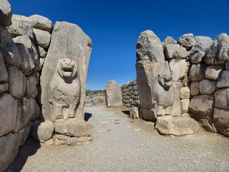
Building a capital on a steep hillside sounds like a bad idea, yet the Hittites made it work. Hattusha served as the heart of their empire in the second millennium B.C.
The slopes became a feature, not a flaw.
The city had an upper and a lower district, each with its own role. Temples, royal residences, and storage areas filled the space.
Strong walls and monumental gates, including the Lion Gate and the Royal Gate, guarded the edges.
Gates did more than keep enemies out. Their carved figures told visitors who held power inside.
Just outside town, the rock sanctuary of Yazılıkaya has carved processions of gods along natural stone walls. It suggests that ceremony was deeply tied to the landscape.
Hattusha shows how the Hittites mixed politics, religion, trade, and defense in one city plan. It was a capital built to impress, to protect, and to run an empire.
Petra, Jordan
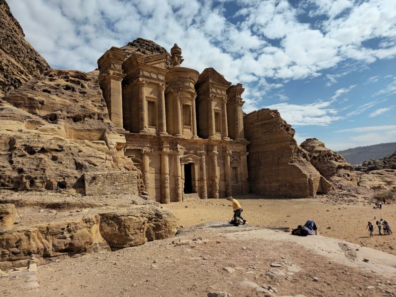
Rain barely falls here, yet Petra once bustled with traders, gardens, and fountains. The Nabataeans solved the water puzzle with channels, tunnels, dams, cisterns, and reservoirs.
They caught seasonal floods and stored every precious drop.
Their capital sat among sandstone mountains and gorges. Builders carved tombs and temples straight into the rock, while also putting up regular buildings, streets, and public spaces.
Caravans carrying goods between Arabia, Egypt, and the Mediterranean passed through, which made the city rich. Later, Roman and Byzantine builders added their own structures to the mix.
The Treasury gets the glory in photos, but the real star is the water system. Without it, none of the carved beauty would have had a city to serve.
Petra shows that clever engineering can turn a harsh desert into a thriving home. A walk through its narrow canyon entrance is a great way to feel that ingenuity in the cool shadows.
Ephesus, Türkiye
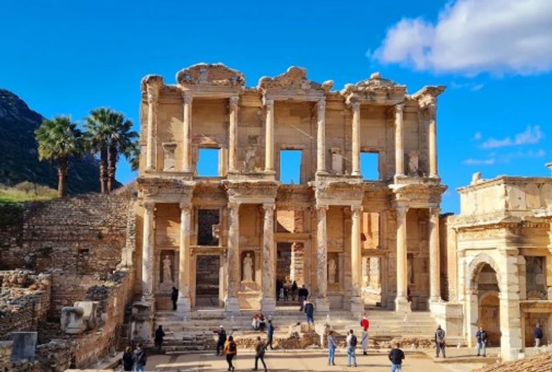
Ephesus once had a harbor, but the sea slowly walked away. As silt built up, the port lost its access to the water, and the city’s economy changed with it.
That makes it a lesson in how nature shapes towns.
This Hellenistic and Roman port city left behind streets, gateways, baths, theaters, temples, and markets. The Library of Celsus and the Great Theatre draw the crowds.
Yet the terraced houses may be even more interesting.
Wealthy families lived there with mosaics, painted walls, and running water. You can see how comfortable life could be for the well-off in a Roman city.
The site also shows how the city moved as the coastline shifted. Builders kept adapting, but the changing environment eventually won.
Wandering down its marble-paved main road, visitors can imagine sailors, shoppers, and officials all jostling for space. Ephesus gives a full view of work, worship, and everyday comfort.
Pompeii, Italy
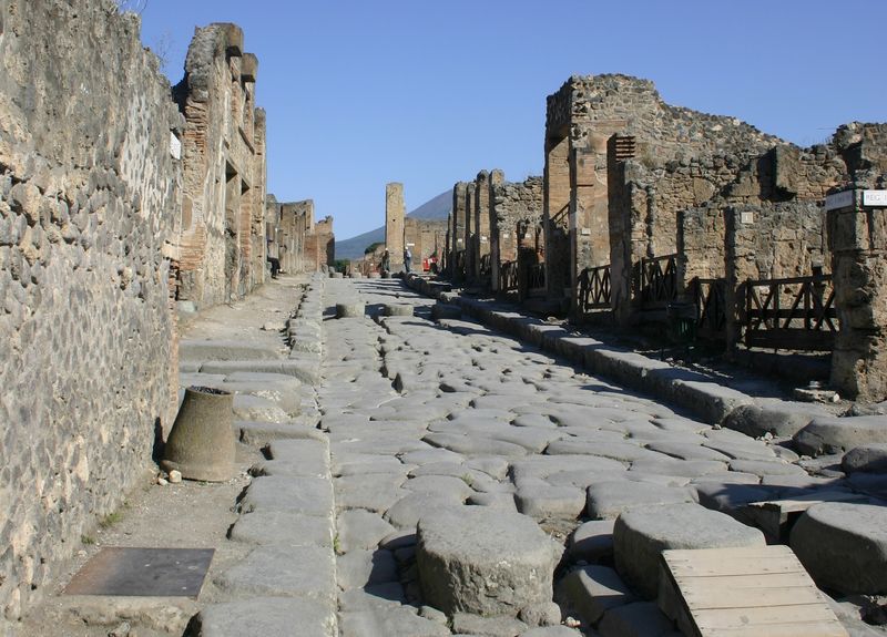
One bad day in A.D. 79 turned Pompeii into the world’s most detailed Roman snapshot. Volcanic material from Mount Vesuvius buried the city and preserved it.
Streets, shops, homes, and temples were sealed in place.
Stroll its lanes and you will notice big stepping stones across the road. They kept pedestrians’ feet dry when water or waste ran through the streets.
Nearby, shop counters once served hot food to hungry customers.
Rich villas with painted rooms and gardens stand near modest homes and workshops. That mix shows how wealth shaped daily life in different neighborhoods.
Baths, theaters, and temples reveal where people relaxed and worshipped. Water pipes and fountains show how the city kept its supply flowing.
UNESCO considers Pompeii and nearby Herculaneum unmatched for showing Roman urban life so completely. Few places let you see a lunch counter from nearly two thousand years ago.
Teotihuacan, Mexico
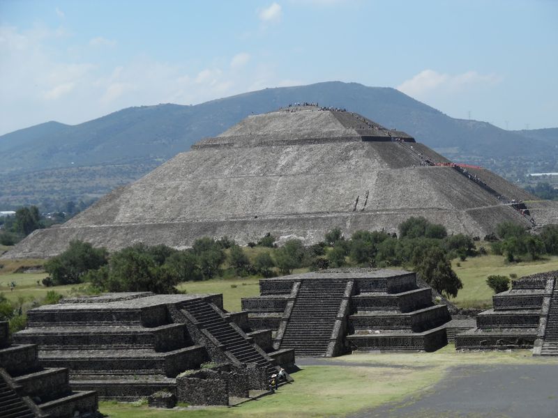
Walk the Avenue of the Dead and your legs will quickly learn how big this city was. Teotihuacan became one of the largest cities in the ancient Americas between the first and seventh centuries A.D.
Its long main road ties together a massive ceremonial center.
The Pyramids of the Sun and Moon dominate the view, and the Temple of Quetzalcoatl adds more drama. But the city spread far beyond them.
Residential compounds, workshops, murals, and orderly streets show a planned urban society. Tens of thousands of people lived here, and many made crafts that were traded widely.
Evidence also points to links with other parts of Mesoamerica. Teotihuacan was not a lonely giant but a connected one.
The grid-like layout suggests that religion, politics, work, and home life were closely tied together. Climbing a pyramid here gives a great view of that careful design.
Tikal, Guatemala
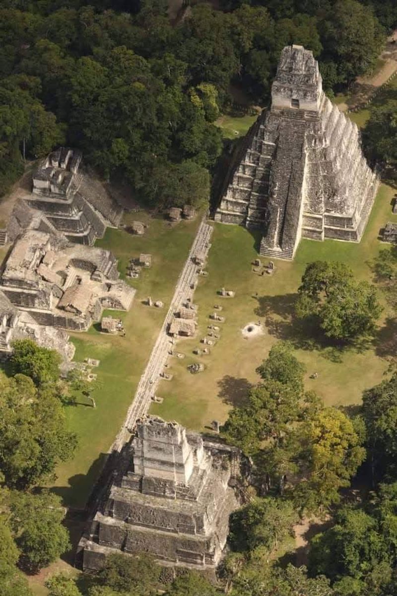
Howler monkeys shout from the treetops while stone temples poke through the jungle canopy. That is Tikal, a major Maya center in northern Guatemala.
People lived here from roughly the sixth century B.C. to around A.D. 900.
The core of the city holds palaces, temples, plazas, ball courts, and ceremonial platforms. Causeways link major areas, making movement easy for processions and travelers.
Look beyond the pyramids and you find reservoirs, farmland, and smaller settlements. Maya engineers collected rainwater to get through the dry season.
A big population needed a steady supply of food and water.
Carved monuments record the names of rulers and their relationships with other cities across centuries. They read like a royal news feed in stone.
Tikal shows that Maya cities were working landscapes, not just collections of pyramids. Farming, water control, trade, and government all kept the place running.
Chichén Itzá, Mexico
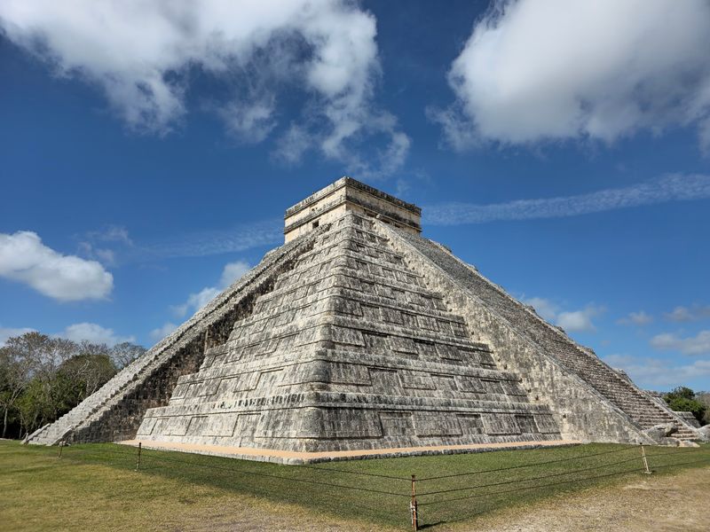
Twice a year, the stairs of El Castillo seem to wriggle with a shadow shaped like a snake. Chichén Itzá is full of clever design like this.
Its builders cared deeply about the sky and the seasons.
The city rose near cenotes, natural sinkholes that held underground water. The northern Yucatán has few rivers, so these water sources were vital.
They shaped where people settled and how the city grew.
Major monuments include El Castillo, the Temple of the Warriors, several ball courts, and the round El Caracol, often called an observatory. Maya traditions mix with styles from central Mexico, which hints at long-distance contact.
Religion, astronomy, and politics all appear in the architecture. Even the water was sacred, as cenotes were used in ritual.
Chichén Itzá shows how a city can weave practical needs and spiritual life into one plan. Go early in the morning if you want to enjoy it with fewer crowds.
Mesa Verde, Colorado
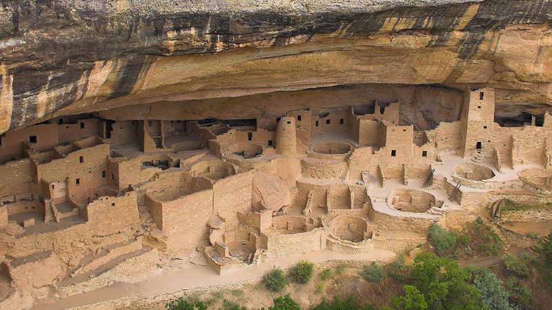
Tucked beneath giant rock overhangs, whole villages once sat safe from sun and snow. Mesa Verde holds around 600 cliff dwellings and thousands of other archaeological sites.
They date from roughly A.D. 450 to 1300.
The cliff homes get the fame, and some have dozens or even over 100 rooms. But much of daily life happened on top of the mesa.
Farming terraces, field houses, and shrines are scattered across the plateau.
Reservoirs, check dams, and irrigation features show how people handled a dry and unpredictable climate. Collecting water was a year-round job.
Because the record covers nearly nine centuries, archaeologists can track changes in houses, farming, and community life. Early pit houses gave way to masonry villages, and later to cliff dwellings.
Mesa Verde proves that Ancestral Puebloan people were skilled builders and careful land managers. Their stone walls still stand in the quiet canyon air.
Angkor, Cambodia
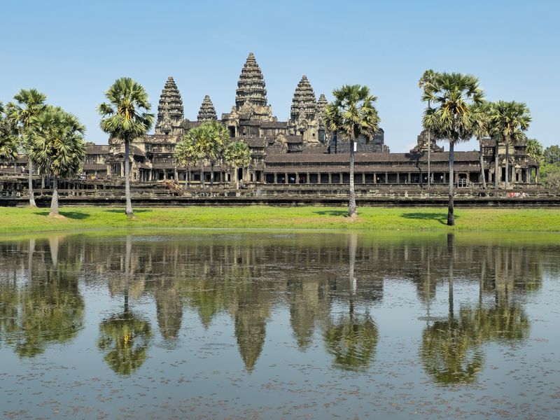
Angkor Wat gets the postcards, but the real wonder is what lies around it. The Khmer capitals spread across about 400 square kilometers.
Between the ninth and 15th centuries, builders added roads, canals, embankments, and giant reservoirs.
Temples such as Angkor Wat and the Bayon show off royal power and religious devotion. Yet the water system explains how so many people could live here.
Canals and reservoirs helped manage heavy rains and dry spells, which supported rice farming.
Research shows Angkor was a huge low-density urban complex, not just a temple zone. Homes, fields, and waterways were mixed across the land.
Think of it as a city that sprawled like a giant garden, with temples as the landmarks. That is closer to the truth than a simple walled town.
Angkor stands as one of the clearest examples of rulers shaping an entire landscape through planning and engineering. Rent a bicycle and you can see just how far it stretches.
Great Zimbabwe, Zimbabwe
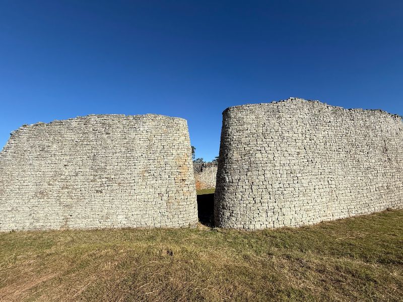
Not a single drop of mortar holds these walls together. Great Zimbabwe’s builders stacked carefully shaped stones so tightly that they stand strong centuries later.
The city thrived from about the 11th to the 15th centuries.
The site has three main parts: the Hill Complex, the Valley Ruins, and the huge Great Enclosure. Elite, ceremonial, and everyday spaces were spread over a wide landscape.
Imported goods found here show trade links reaching the Indian Ocean world. Wealth came from cattle, farming, gold, and commerce.
Even with those global ties, the architecture follows local Shona building traditions. Early outside observers often refused to believe Africans built it, but the evidence clearly says otherwise.
Great Zimbabwe is powerful proof of a rich, homegrown African urban civilization. Its curved walls are as graceful as they are strong.
Machu Picchu, Peru
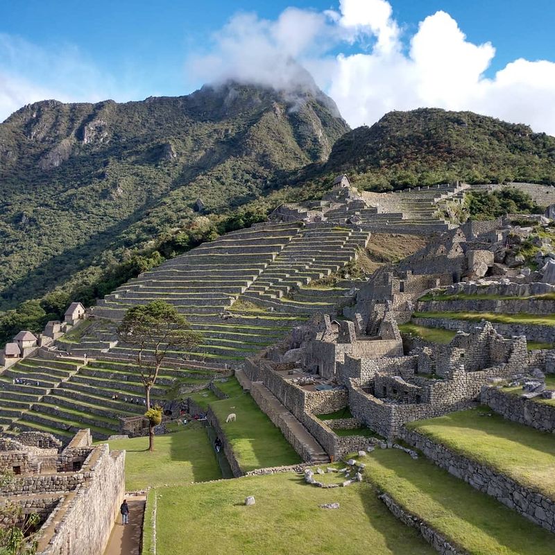
At about 2,430 meters above sea level, even breathing feels like a workout. Machu Picchu sits on a steep Andean ridge, and the Inca made it look effortless.
Terraces, stairways, plazas, and homes fit the slopes like they grew there.
The terraces did double duty. They held the hillsides in place and gave space for growing crops.
Stone channels carried water through the site, keeping it fresh and draining away heavy rain.
Inca masons fitted stones so closely that walls could handle earthquakes better than you might expect. Rather than flatten the mountain, they worked with existing rock and shape.
Ceremonial structures sit near living areas, showing how daily and sacred life mixed. Farming, building, and belief were all planned together.
Machu Picchu remains one of the best examples of design that respects its landscape. Bring a rain jacket, because the mountain weather changes fast.
Share this story